Drought, Deluge Turned Stable California Landslide into Disaster in 2017
Special Stories
15 Feb 2019 9:42 AM
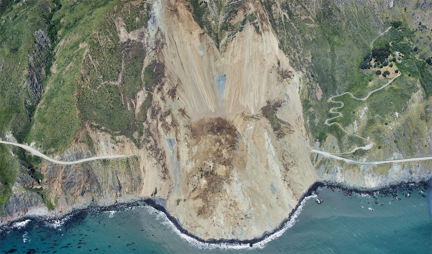
[USGS air photo of the Mud Creek landslide in California, taken on May 27, 2017]
[NASA]"Stable landslide" sounds like a contradiction in terms, but there are indeed places on Earth where land has been creeping downhill slowly, stably and harmlessly for as long as a century. But stability doesn't necessarily last forever. For the first time, researchers at NASA's Jet Propulsion Laboratory in Pasadena, California, and collaborating institutions have documented the transition of a stable, slow-moving landslide into catastrophic collapse, showing how drought and extreme rains likely destabilized the slide.
On May 20, 2017, more than 6 million cubic yards (5 million cubic meters) of rock and dirt—enough to fill a line of dump trucks nearly a thousand miles long—collapsed down the steep slopes at Mud Creek on California’s Big Sur coast, about 140 miles south of San Francisco. A pile of rubble almost a third of a mile wide buried California State Highway 1 more than 65 feet deep and added about 13 acres of new land to the coast. The damage took more than a year and $54 million to repair. No long-term motion had been documented at Mud Creek before this event, but workers in the state's transportation department had noticed small mudslides in the weeks before the collapse and closed the highway as a precaution.
The JPL-led team identified Mud Creek as a stable landslide using an eight-year data set from an airborne JPL instrument called the Uninhabited Airborne Vehicle Synthetic Aperature Radar, processed with a technique called interferometric synthetic aperture radar processing (InSAR). They calculated that Mud Creek had been sliding at an average speed of about 7 inches (17 centimeters) per year since at least 2009. They used the European Space Agency's Sentinel-1A/B satellite data to document how the sliding area's behavior changed.
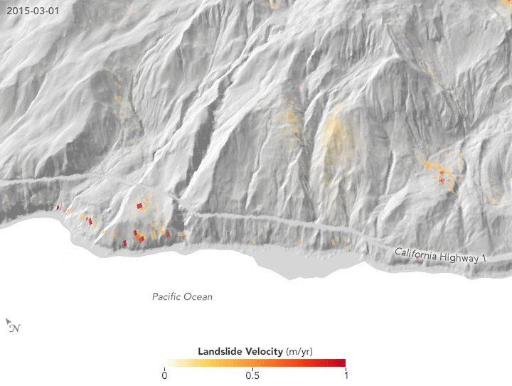 [Velocity changes in the slide area, March 2015 to May 2017. In winter 2015-16, slide speeds increased with the winter rains and then slowed steadily until the following winter. In winter 2016-17, heavy rains caused the landslide to accelerate twice, first in December 2016 and then again in March 2017. The scientists think the double acceleration may have been a signal of the impending collapse in May. Credits: NASA Earth Observatory]
The airborne and satellite data measure changes only at the ground surface, however. "From that, we tried to infer what may have happened to the landslide's sliding surface, tens of meters underground, that allowed the Mud Creek slide to transition from stable to unstable," said the study's lead author, Alexander Handwerger, a NASA postdoctoral fellow doing research at JPL.
The collapse happened after several days of heavy rainfall during one of the wettest years in over a century for this area. Before 2017, a five-year drought had produced several of California's hottest and driest years ever. Using a computer model of how water affects soil, the researchers studied what would happen as the intense rains saturated the parched ground. Water would replace air in the tiny spaces between soil particles, greatly increasing the pressure on the particles. This pressure change could have destabilized the sliding surfaces below ground and triggered the collapse.
California alone has more than 650 known stable landslides. If one began losing stability in the future, could InSAR data reveal the change? To answer that question, the team compared the Mud Creek images with images of two other stable landslides in similar types of soil and rock.
[Velocity changes in the slide area, March 2015 to May 2017. In winter 2015-16, slide speeds increased with the winter rains and then slowed steadily until the following winter. In winter 2016-17, heavy rains caused the landslide to accelerate twice, first in December 2016 and then again in March 2017. The scientists think the double acceleration may have been a signal of the impending collapse in May. Credits: NASA Earth Observatory]
The airborne and satellite data measure changes only at the ground surface, however. "From that, we tried to infer what may have happened to the landslide's sliding surface, tens of meters underground, that allowed the Mud Creek slide to transition from stable to unstable," said the study's lead author, Alexander Handwerger, a NASA postdoctoral fellow doing research at JPL.
The collapse happened after several days of heavy rainfall during one of the wettest years in over a century for this area. Before 2017, a five-year drought had produced several of California's hottest and driest years ever. Using a computer model of how water affects soil, the researchers studied what would happen as the intense rains saturated the parched ground. Water would replace air in the tiny spaces between soil particles, greatly increasing the pressure on the particles. This pressure change could have destabilized the sliding surfaces below ground and triggered the collapse.
California alone has more than 650 known stable landslides. If one began losing stability in the future, could InSAR data reveal the change? To answer that question, the team compared the Mud Creek images with images of two other stable landslides in similar types of soil and rock.
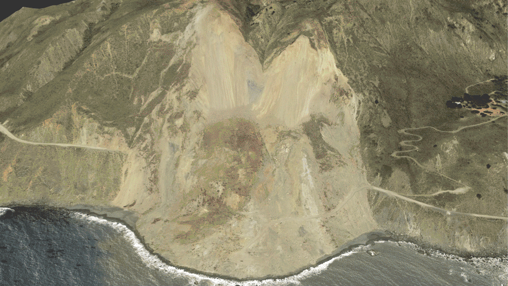 [The Mud Creek landslide in photographic and radar images. The radar velocity map shows the pre-collapse (solid line) and post-collapse (dashed line) extent of the sliding area, with faster sliding velocities before the collapse shown in darker shades of red. The highest velocities were about 16 inches (40 centimeters) per year.Credits: Google/SIO/NOAA/U.S. Navy/NGA/GEBCO/Landsat/Copernicus]
Paul's Slide, only 13 miles (21 kilometers) north of Mud Creek, went through the same weather conditions yet did not fail catastrophically. A landslide in Northern California received over 3 feet (1 meter) more rainfall than Mud Creek without catastrophic failure. "We thought if we compared these two cases that didn't fail to the one that did, we might find some characteristic velocity pattern that would be a warning that a slide was going to fail catastrophically," Handwerger said.
The idea paid off. Handwerger found that all three stable slides accelerated slightly after the winter rainy season started and then, as the season continued, slowed down again and stabilized. This is their usual annual pattern. But after the late-season rains, Mud Creek accelerated again, increasing in speed until its ultimate collapse. The other slides did not.
"We think that second speed-up may be a signal of interest, but we only have this one case," Handwerger said. "Since we now know that stable landslides in this region can fail catastrophically and we have good data coverage here, our plan is to monitor this whole stretch of the Pacific Coast Highway and look for these unusual velocity changes. If we get enough examples, we can start to actually figure out the mechanisms that are controlling this behavior."
The paper on the research, titled "A shift from drought to extreme rainfall drives a stable landslide to catastrophic failure," was published recently in Scientific Reports. Coauthors represent JPL; the University of Maryland in College Park; Portland State University in Oregon; and the University of California, Berkeley. You can read more about the landslide at the USGS.
Edited for WeatherNation by Meteorologist Mace Michaels
[The Mud Creek landslide in photographic and radar images. The radar velocity map shows the pre-collapse (solid line) and post-collapse (dashed line) extent of the sliding area, with faster sliding velocities before the collapse shown in darker shades of red. The highest velocities were about 16 inches (40 centimeters) per year.Credits: Google/SIO/NOAA/U.S. Navy/NGA/GEBCO/Landsat/Copernicus]
Paul's Slide, only 13 miles (21 kilometers) north of Mud Creek, went through the same weather conditions yet did not fail catastrophically. A landslide in Northern California received over 3 feet (1 meter) more rainfall than Mud Creek without catastrophic failure. "We thought if we compared these two cases that didn't fail to the one that did, we might find some characteristic velocity pattern that would be a warning that a slide was going to fail catastrophically," Handwerger said.
The idea paid off. Handwerger found that all three stable slides accelerated slightly after the winter rainy season started and then, as the season continued, slowed down again and stabilized. This is their usual annual pattern. But after the late-season rains, Mud Creek accelerated again, increasing in speed until its ultimate collapse. The other slides did not.
"We think that second speed-up may be a signal of interest, but we only have this one case," Handwerger said. "Since we now know that stable landslides in this region can fail catastrophically and we have good data coverage here, our plan is to monitor this whole stretch of the Pacific Coast Highway and look for these unusual velocity changes. If we get enough examples, we can start to actually figure out the mechanisms that are controlling this behavior."
The paper on the research, titled "A shift from drought to extreme rainfall drives a stable landslide to catastrophic failure," was published recently in Scientific Reports. Coauthors represent JPL; the University of Maryland in College Park; Portland State University in Oregon; and the University of California, Berkeley. You can read more about the landslide at the USGS.
Edited for WeatherNation by Meteorologist Mace Michaels
[Velocity changes in the slide area, March 2015 to May 2017. In winter 2015-16, slide speeds increased with the winter rains and then slowed steadily until the following winter. In winter 2016-17, heavy rains caused the landslide to accelerate twice, first in December 2016 and then again in March 2017. The scientists think the double acceleration may have been a signal of the impending collapse in May. Credits: NASA Earth Observatory]
The airborne and satellite data measure changes only at the ground surface, however. "From that, we tried to infer what may have happened to the landslide's sliding surface, tens of meters underground, that allowed the Mud Creek slide to transition from stable to unstable," said the study's lead author, Alexander Handwerger, a NASA postdoctoral fellow doing research at JPL.
The collapse happened after several days of heavy rainfall during one of the wettest years in over a century for this area. Before 2017, a five-year drought had produced several of California's hottest and driest years ever. Using a computer model of how water affects soil, the researchers studied what would happen as the intense rains saturated the parched ground. Water would replace air in the tiny spaces between soil particles, greatly increasing the pressure on the particles. This pressure change could have destabilized the sliding surfaces below ground and triggered the collapse.
California alone has more than 650 known stable landslides. If one began losing stability in the future, could InSAR data reveal the change? To answer that question, the team compared the Mud Creek images with images of two other stable landslides in similar types of soil and rock.
[The Mud Creek landslide in photographic and radar images. The radar velocity map shows the pre-collapse (solid line) and post-collapse (dashed line) extent of the sliding area, with faster sliding velocities before the collapse shown in darker shades of red. The highest velocities were about 16 inches (40 centimeters) per year.Credits: Google/SIO/NOAA/U.S. Navy/NGA/GEBCO/Landsat/Copernicus]
Paul's Slide, only 13 miles (21 kilometers) north of Mud Creek, went through the same weather conditions yet did not fail catastrophically. A landslide in Northern California received over 3 feet (1 meter) more rainfall than Mud Creek without catastrophic failure. "We thought if we compared these two cases that didn't fail to the one that did, we might find some characteristic velocity pattern that would be a warning that a slide was going to fail catastrophically," Handwerger said.
The idea paid off. Handwerger found that all three stable slides accelerated slightly after the winter rainy season started and then, as the season continued, slowed down again and stabilized. This is their usual annual pattern. But after the late-season rains, Mud Creek accelerated again, increasing in speed until its ultimate collapse. The other slides did not.
"We think that second speed-up may be a signal of interest, but we only have this one case," Handwerger said. "Since we now know that stable landslides in this region can fail catastrophically and we have good data coverage here, our plan is to monitor this whole stretch of the Pacific Coast Highway and look for these unusual velocity changes. If we get enough examples, we can start to actually figure out the mechanisms that are controlling this behavior."
The paper on the research, titled "A shift from drought to extreme rainfall drives a stable landslide to catastrophic failure," was published recently in Scientific Reports. Coauthors represent JPL; the University of Maryland in College Park; Portland State University in Oregon; and the University of California, Berkeley. You can read more about the landslide at the USGS.
Edited for WeatherNation by Meteorologist Mace MichaelsAll Weather News
More
Colder Air Returns to the Central U.S.
In the next few days, spring-like temperature
19 Apr 2024 1:00 PM
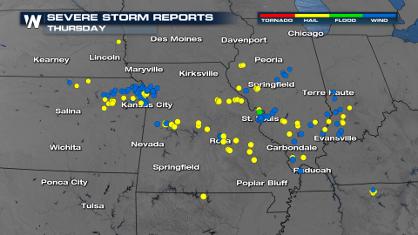
More Severe Weather From the Plains to Southeast
It has been a busy week as severe weather rip
19 Apr 2024 3:00 AM
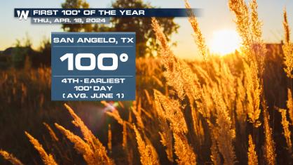
Record Heat Along the Gulf Coast Today
Summer-like temperatures are expected across
19 Apr 2024 2:50 AM
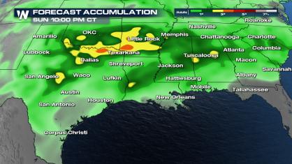
Wet and Cool Weekend in the Deep South
We're looking at a wet end of the week for th
19 Apr 2024 2:45 AM

Double Trouble: Cicadas Take to the Skies this Spring
It’s the soundtrack to the summer. Nature’s n
19 Apr 2024 2:40 AM

National Park Week: Get Out and Explore
National Park Week starts April 20th and runs
19 Apr 2024 2:35 AM

Ef-2 Tornadoes Touch Down in Kansas, Iowa
Severe storms moved across the Midwest Tuesda
18 Apr 2024 1:00 PM