Ferguson Fire Keeps Parts of Yosemite National Park Closed
Top Stories
28 Jul 2018 4:45 PM
The Ferguson Fire in northern California is now in it's 16th day, and continues to char thousands of acres each day. The fire has burned 49,619 acres, and is just 29% contained. The resources being used to battle the blaze are staggering... 3,898 personnel... 282 engines... 46 water tenders... 16 helicopters... 5 masticators... and 81 dozers. There has been 1 fatality and 7 injuries. 1 structure has been destroyed. However, over 5,000 structures are still being threatened. The fire started on July 13, in the Sierra National Forest. Much of the fire is burning in steep rugged terrain with very few access roads. To this point, no homes have been damaged or destroyed.
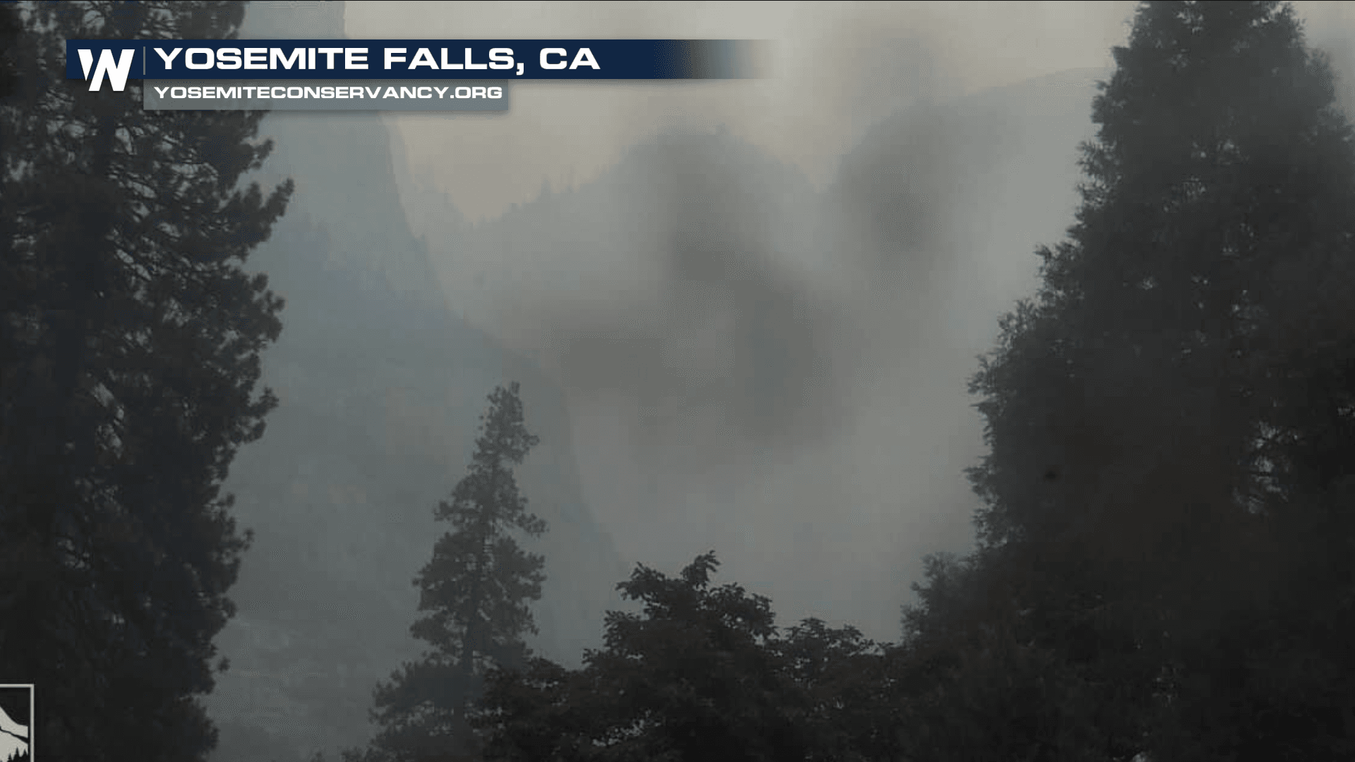
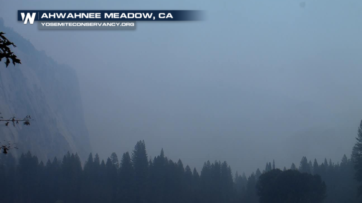
Yosemite Valley has been temporarily closed since July 25 due to smoke impacts and for firefighting operations along El Portal Road and Wawona Road. Several other park facilities and roads have been closed as well. These closures include Glacier Point Road, Bridalveil Creek Campground, and Wawona Campground. The Merced Grove of Giant Sequoias has also been off-limits to visitors. Firefighters have been working diligently, not only to extinguish the flames, but to protect parts of Yosemite potentially in the fire's path.
https://twitter.com/YosemiteFire/status/1022982441013657601
Park officials hoped to reopen Yosemite Valley by Sunday. However, although flames are not threatening the valley, air quality remains very poor due to thick smoke. Earlier today, officials announced that Yosemite Valley will reopen to all visitors at 4:00 pm on Friday, August 3, 2018. Limited visitor services will be available inside Yosemite Valley, including campgrounds, lodging, and food service operations.
However, due to continuing firefighting operations along Wawona Road, the Mariposa Grove of Giant Sequoias will remain closed until further notice. Highway 41 from the South Entrance of Yosemite National Park to Tunnel View will also remain closed until further notice.
 The Hetch Hetchy area remains open. The Big Oak Flat Road (Highway 120 West) to Crane Flat and Tioga Road (Highway 120 East) from Crane Flat to Tioga Pass remain open to all visitors and vehicles. All trails and campgrounds along Tioga Road, including the Tuolumne Meadows Campground remain open. All visitor services along Tioga Road, including the High Sierra Camps and visitor services near Tuolumne Meadows remain open.
The Ferguson Fire, burning in Merced River Canyon, is not expected to be fully contained for at least another two weeks. Updated 24-hour road and weather conditions for Yosemite National Park can be obtained by calling 209-372-0200, press 1 and press 1 again. You can also find updated information on the park’s website... www.nps.gov/yose and on the park's facebook page.
Below are lists of Current Road Closures... Mandatory Evactuations... and Evacuation Advisories due to the Ferguson Fire:
ROAD CLOSURES:
Triangle Road, from Darrah Road to Hwy 49 south Chowchilla Mountain Road, at Hwy 49 south
Harris Road, at Hwy 49 south
Tip Top Road, from Triangle Road to Gunther Road
All roads inside Lushmeadows Subdivision
All roads inside Ponderosa Basin Subdivision
Hwy 140 is closed from 1.9 miles east of Midpines to the Cedar Lodge area MOTORISTS ARE ADVISED TO USE AN ALTERNATE ROUTE
Highway 140 is closed from the entrance of Yosemite National Park to 1.5 miles east of Midpines. Incline Road, River Road from Briceburg to the gate at Railroad Flat and all Campground areas along Highway 140 closed. Hites Cove/Jerseydale Road, Foresta Road, Anderson Valley Road, Summit Road and Old Yosemite Road. Chowchilla Mountain Road at Highway 49 South, Harris Road at Highway 49 South, Tip Top Road from Triangle Road to Gunther Road, and all roads inside the Ponderosa Basin subdivision.
Wawona Road (Highway 41) between Chilnualna Falls Road in Wawona and Bridalveil Falls Road in Yosemite Valley.
MANDATORY EVACUATIONS:
Anderson Valley
Cedar Lodge/Indian Flat Campground
East Westfall Road to Chowchilla mountain Road, and all side roads
El Portal Trailer Court
Foresta
Incline Road from Foresta Bridge to the last BLM campground
Lushmeadows Community
Old El Portal
Old Yosemite Road
Ponderosa Basin Community
Rancheria Flat – Government Housing
Savage’s Trading Post
Tip Top Road from Triangle Road to Gunther Road, including Gunther Road
Triangle Road from Darrah Road in the Lushmeadows area to Highway 49 South, and all side roads
Yosemite View Lodge
Yosemite West
EVACUATION ADVISORIES:
This is NOT an Evacuation Order. This is an advisement only of a potential Evacuation Order should conditions change.
East side of Highway 49 South from Darrah Road to Triangle Road. This includes Boyer Road, Woodland Area, Wass Road and Tip Top Road.
Highway 49 South from Stumpfield Mountain Road to the Mariposa-Madera County Line, including Kemble Road, Stumpfield Mountain Road and Watt Road
Mariposa Pines/Jerseydale Road
Triangle Road from Jerseydale Road to East Westfall
For WeatherNation: Meteorologist Matt Monroe
The Hetch Hetchy area remains open. The Big Oak Flat Road (Highway 120 West) to Crane Flat and Tioga Road (Highway 120 East) from Crane Flat to Tioga Pass remain open to all visitors and vehicles. All trails and campgrounds along Tioga Road, including the Tuolumne Meadows Campground remain open. All visitor services along Tioga Road, including the High Sierra Camps and visitor services near Tuolumne Meadows remain open.
The Ferguson Fire, burning in Merced River Canyon, is not expected to be fully contained for at least another two weeks. Updated 24-hour road and weather conditions for Yosemite National Park can be obtained by calling 209-372-0200, press 1 and press 1 again. You can also find updated information on the park’s website... www.nps.gov/yose and on the park's facebook page.
Below are lists of Current Road Closures... Mandatory Evactuations... and Evacuation Advisories due to the Ferguson Fire:
ROAD CLOSURES:
Triangle Road, from Darrah Road to Hwy 49 south Chowchilla Mountain Road, at Hwy 49 south
Harris Road, at Hwy 49 south
Tip Top Road, from Triangle Road to Gunther Road
All roads inside Lushmeadows Subdivision
All roads inside Ponderosa Basin Subdivision
Hwy 140 is closed from 1.9 miles east of Midpines to the Cedar Lodge area MOTORISTS ARE ADVISED TO USE AN ALTERNATE ROUTE
Highway 140 is closed from the entrance of Yosemite National Park to 1.5 miles east of Midpines. Incline Road, River Road from Briceburg to the gate at Railroad Flat and all Campground areas along Highway 140 closed. Hites Cove/Jerseydale Road, Foresta Road, Anderson Valley Road, Summit Road and Old Yosemite Road. Chowchilla Mountain Road at Highway 49 South, Harris Road at Highway 49 South, Tip Top Road from Triangle Road to Gunther Road, and all roads inside the Ponderosa Basin subdivision.
Wawona Road (Highway 41) between Chilnualna Falls Road in Wawona and Bridalveil Falls Road in Yosemite Valley.
MANDATORY EVACUATIONS:
Anderson Valley
Cedar Lodge/Indian Flat Campground
East Westfall Road to Chowchilla mountain Road, and all side roads
El Portal Trailer Court
Foresta
Incline Road from Foresta Bridge to the last BLM campground
Lushmeadows Community
Old El Portal
Old Yosemite Road
Ponderosa Basin Community
Rancheria Flat – Government Housing
Savage’s Trading Post
Tip Top Road from Triangle Road to Gunther Road, including Gunther Road
Triangle Road from Darrah Road in the Lushmeadows area to Highway 49 South, and all side roads
Yosemite View Lodge
Yosemite West
EVACUATION ADVISORIES:
This is NOT an Evacuation Order. This is an advisement only of a potential Evacuation Order should conditions change.
East side of Highway 49 South from Darrah Road to Triangle Road. This includes Boyer Road, Woodland Area, Wass Road and Tip Top Road.
Highway 49 South from Stumpfield Mountain Road to the Mariposa-Madera County Line, including Kemble Road, Stumpfield Mountain Road and Watt Road
Mariposa Pines/Jerseydale Road
Triangle Road from Jerseydale Road to East Westfall
For WeatherNation: Meteorologist Matt MonroeAll Weather News
More

Rain and Spring Snow for the Northeast
As a low-pressure system worked through Tuesd
24 Apr 2024 4:50 PM
Weekend Forecast: More Severe Weather in the Plains
We are looking at the threat of another sever
24 Apr 2024 1:20 PM

NOAA Debuts "HeatRisk" Tool Nationwide
More people die from heat every year than ALL
24 Apr 2024 1:00 PM

National Park Week: Get Out and Explore
National Park Week started Saturday, April 20
24 Apr 2024 7:35 AM

Record Warmth to Weekend Snow in the Four Corners
Snow is in the forecast for Denver, which cou
23 Apr 2024 5:25 PM