History Shows Quiet or Active Hurricane Phases Doesn't Equal More or Less Landfalls
Special Stories
20 Jun 2018 8:21 AM
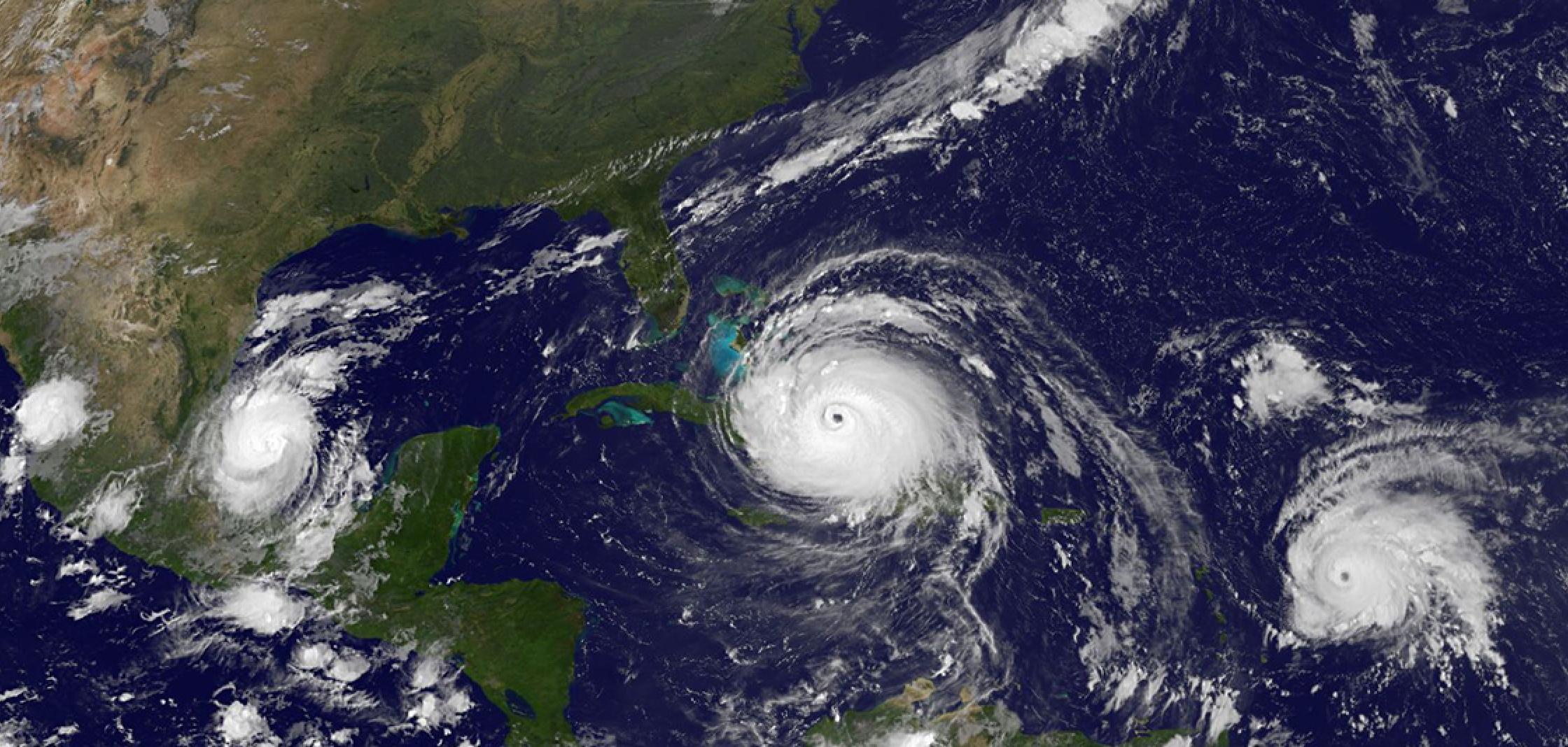
[GOES 16 full disk image of hurricanes Katia, Irma and Jose captured September 8, 2017. From NOAA]
From NOAA by Rebecca Lindsey
The hurricane record from the Atlantic Ocean shows phases of high and low activity that can last several decades at a time. Active eras spawn more hurricanes per season on average, especially major hurricanes. All else being equal, more major hurricanes overall ought to mean more major hurricane landfalls in the United States, but records show that isn’t the case. These maps show one possible explanation for that puzzle: otherwise active hurricane eras appear to have a built-in speed bump for major hurricanes that approach the U.S.
Based on research by NOAA hurricane expert Jim Kossin, the maps below show the difference in vertical wind shear (top map) and sea surface temperature (bottom map) between the current active hurricane era (1993-2015) and the previous quiet period (1970-1992). Across most of the tropical Atlantic (where hurricanes form), average climate conditions since the mid-1990s have been especially friendly to hurricanes, with higher ocean surface temperatures (darker reds) and weaker vertical wind shear (greens). But over the Gulf of Mexico and off the U.S. southeastern seaboard, the pattern is reversed: cooler temperatures (relative to the main development region) and stronger vertical wind shear, both of which weaken hurricanes.
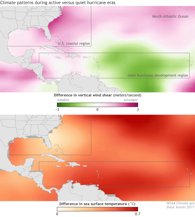 On the one hand, this might seem like a stroke of amazingly good luck—just when the country would otherwise be at higher risk of a major landfalling hurricane, the climate system offers up some built-in protection. Unfortunately, this shiny penny has a tarnished flip side. During the quiet era, hurricanes that did approach the United States—especially major hurricanes—were more likely to intensify rapidly.
As the maps show, areas near the U.S. coast tended to be warmer during the quiet period, and the wind shear tended to be weaker. While the average number of hurricanes that formed per season across the entire Atlantic basin was lower during the quiet era, the ones that did approach the United States were more likely to encounter very hurricane-friendly conditions. This relationship also showed up in comparisons between the 1970-1992 quiet era and the active period that preceded it from 1947-1969.
Kossin found that during the quiet period, a major hurricane near the U.S. coast was 3-6 times more likely to intensify by 15 knots within 6 hours than it was during the active periods. Unfortunately, Kossin points out, “Rapid intensification near the coast poses a very significant risk because it is difficult to forecast and shortens public warning time.”
On the one hand, this might seem like a stroke of amazingly good luck—just when the country would otherwise be at higher risk of a major landfalling hurricane, the climate system offers up some built-in protection. Unfortunately, this shiny penny has a tarnished flip side. During the quiet era, hurricanes that did approach the United States—especially major hurricanes—were more likely to intensify rapidly.
As the maps show, areas near the U.S. coast tended to be warmer during the quiet period, and the wind shear tended to be weaker. While the average number of hurricanes that formed per season across the entire Atlantic basin was lower during the quiet era, the ones that did approach the United States were more likely to encounter very hurricane-friendly conditions. This relationship also showed up in comparisons between the 1970-1992 quiet era and the active period that preceded it from 1947-1969.
Kossin found that during the quiet period, a major hurricane near the U.S. coast was 3-6 times more likely to intensify by 15 knots within 6 hours than it was during the active periods. Unfortunately, Kossin points out, “Rapid intensification near the coast poses a very significant risk because it is difficult to forecast and shortens public warning time.”
 Whether this pattern favoring rapid intensification near the U.S. coast will re-emerge when, or if, the Atlantic basin enters the next quiet era is not certain, of course. The comprehensive hurricane record is less than a century in length, which means that we have only have a few of these decades-long phases to study.
Experts are not even certain these active versus quiet phases are entirely natural; the drop in hurricane activity during the quiet period was probably partly due to air pollution particles, which can cool sea surface temperatures by blocking incoming sunlight. Cleaner air in the decades since may mean that the next “quiet” hurricane era won’t be as quiet as the past one.
Whether this pattern favoring rapid intensification near the U.S. coast will re-emerge when, or if, the Atlantic basin enters the next quiet era is not certain, of course. The comprehensive hurricane record is less than a century in length, which means that we have only have a few of these decades-long phases to study.
Experts are not even certain these active versus quiet phases are entirely natural; the drop in hurricane activity during the quiet period was probably partly due to air pollution particles, which can cool sea surface temperatures by blocking incoming sunlight. Cleaner air in the decades since may mean that the next “quiet” hurricane era won’t be as quiet as the past one.
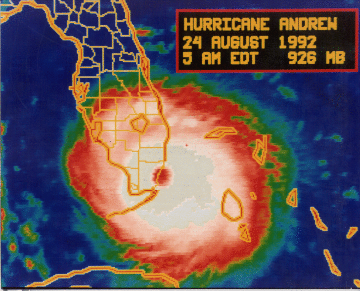 Still, these results suggest that if another quiet era returns, coastal residents should be aware that lower storm numbers in the basin as a whole may mean greater risk when hurricanes approach the U.S. coasts. That was proven in 1992 - only named six storms occurred that season, with only two hitting land areas. But the first that year was category five Hurricane Andrew, one of the most destructive hurricanes to strike Florida with $27.3 billion dollars in damage and 65 fatalities.
Edited for WeatherNation by Meteorologist Mace Michaels
Still, these results suggest that if another quiet era returns, coastal residents should be aware that lower storm numbers in the basin as a whole may mean greater risk when hurricanes approach the U.S. coasts. That was proven in 1992 - only named six storms occurred that season, with only two hitting land areas. But the first that year was category five Hurricane Andrew, one of the most destructive hurricanes to strike Florida with $27.3 billion dollars in damage and 65 fatalities.
Edited for WeatherNation by Meteorologist Mace Michaels
On the one hand, this might seem like a stroke of amazingly good luck—just when the country would otherwise be at higher risk of a major landfalling hurricane, the climate system offers up some built-in protection. Unfortunately, this shiny penny has a tarnished flip side. During the quiet era, hurricanes that did approach the United States—especially major hurricanes—were more likely to intensify rapidly.
As the maps show, areas near the U.S. coast tended to be warmer during the quiet period, and the wind shear tended to be weaker. While the average number of hurricanes that formed per season across the entire Atlantic basin was lower during the quiet era, the ones that did approach the United States were more likely to encounter very hurricane-friendly conditions. This relationship also showed up in comparisons between the 1970-1992 quiet era and the active period that preceded it from 1947-1969.
Kossin found that during the quiet period, a major hurricane near the U.S. coast was 3-6 times more likely to intensify by 15 knots within 6 hours than it was during the active periods. Unfortunately, Kossin points out, “Rapid intensification near the coast poses a very significant risk because it is difficult to forecast and shortens public warning time.”
Whether this pattern favoring rapid intensification near the U.S. coast will re-emerge when, or if, the Atlantic basin enters the next quiet era is not certain, of course. The comprehensive hurricane record is less than a century in length, which means that we have only have a few of these decades-long phases to study.
Experts are not even certain these active versus quiet phases are entirely natural; the drop in hurricane activity during the quiet period was probably partly due to air pollution particles, which can cool sea surface temperatures by blocking incoming sunlight. Cleaner air in the decades since may mean that the next “quiet” hurricane era won’t be as quiet as the past one.
Still, these results suggest that if another quiet era returns, coastal residents should be aware that lower storm numbers in the basin as a whole may mean greater risk when hurricanes approach the U.S. coasts. That was proven in 1992 - only named six storms occurred that season, with only two hitting land areas. But the first that year was category five Hurricane Andrew, one of the most destructive hurricanes to strike Florida with $27.3 billion dollars in damage and 65 fatalities.
Edited for WeatherNation by Meteorologist Mace MichaelsAll Weather News
More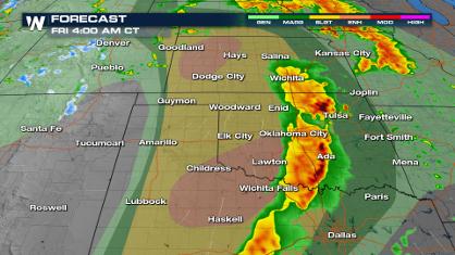
Significant Storm Threat Today, Friday
The spring season often means rounds of stron
25 Apr 2024 5:55 PM
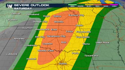
Weekend Forecast: More Severe Weather
We are looking at the threat of another sever
25 Apr 2024 5:50 PM
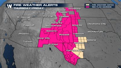
Critical Fire Risk in West Texas, New Mexico
A critical fire risk is in place for west Tex
25 Apr 2024 5:45 PM

National Park Week: Get Out and Explore
National Park Week started Saturday, April 20
25 Apr 2024 1:45 PM

NOAA Debuts "HeatRisk" Tool Nationwide
More people die from heat every year than ALL
25 Apr 2024 1:35 PM

Double Trouble: Cicadas Take to the Skies this Spring
It’s the soundtrack to the summer. Nature’s n
25 Apr 2024 1:25 PM

Record Warmth to Weekend Snow in the Four Corners
Snow is in the forecast for Denver, which cou
25 Apr 2024 1:20 AM