Looking at New Zealand in the Summer to Forecast Southwest Winter Rainfall

Special Stories
11 Jul 2018 8:48 AM
[The water level of the San Luis Reservoir in California’s Merced County fluctuates in wet and dry years. UCI research gives resource managers a new tool for predicting winter rainfall months in advance. From Amir AghaKouchak / UCI]
From University of California - Irvine
El Niño was long considered a reliable tool for predicting future precipitation in the southwestern United States, but its forecasting power has diminished in recent cycles, possibly due to global climate change. In a study published in Nature Communications, scientists and engineers at the University of California, Irvine demonstrate a new method for projecting wet or dry weather in the winter ahead.
“The interhemispheric teleconnection that we have discovered promises earlier and more accurate prediction of winter precipitation in California and the southwestern U.S.,” said study co-author Efi Foufoula-Georgiou, UCI Distinguished Professor of civil & environmental engineering. “Knowing how much rain to expect in the coming winter is crucial for the economy, water security and ecosystem management of the region.”
The researchers called the new teleconnection the New Zealand Index, because the sea surface temperature anomaly that triggers it begins in July and August in the southwestern Pacific Ocean, close to New Zealand. As the sea surface temperature in the region cools down or heats up, it causes a change in the southern Hadley cell, an atmospheric convection zone from the equator to about the 30th parallel south.
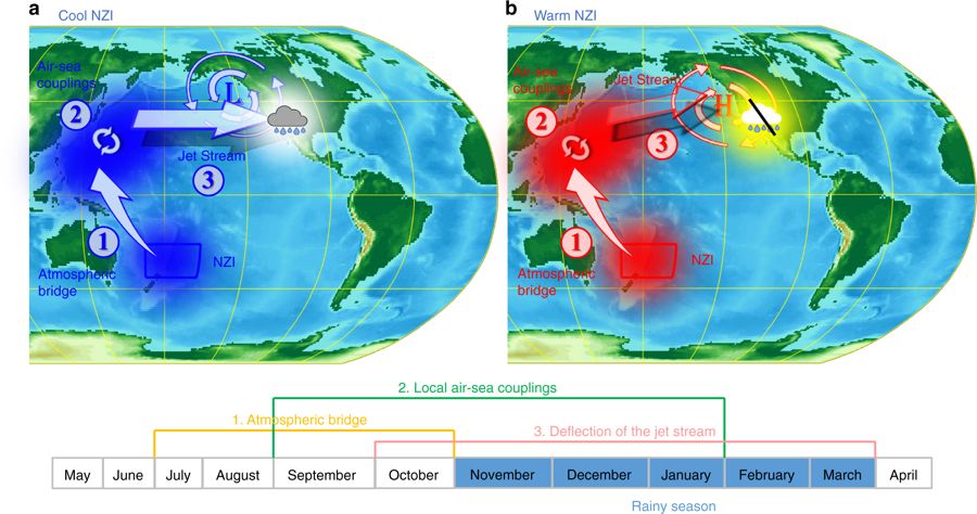 [The New Zealand Index (NZI) teleconnection depends on a western Pacific ocean–atmosphere pathway. a Negative sea surface temperature (SST) anomalies (blue shading) in the NZI region cascade in the northern hemisphere through a late summer interhemispheric atmospheric bridge and are maintained by air-sea coupling until the following winter. The SST anomalies affect the atmospheric pressure in the US west coast and strengthen the regional jet stream which brings more winter storms in the SWUS; b Late-summer positive SST anomalies (red shading) in the NZI region deflect the jet stream to the north, leading to dry conditions over the SWUS]
This prompts a commensurate anomaly east of the Philippine Islands, which, in turn, results in a strengthening or weakening of the jet stream in the Northern Hemisphere, having a direct influence on the amount of rain that falls on California between November and March.
“With the New Zealand Index, we can predict from late summer the likelihood of above- or below-normal winter precipitation in the southwestern U.S., with a correlation in the order of 0.7 – compared to the El Niño-Southern Oscillation technique, which has a correlation around 0.3 to 0.4,” said lead author Antonios Mamalakis, a UCI graduate student in civil & environmental engineering. “Our research also shows an amplification of this newly discovered teleconnection over the past four decades.”
For the study, an interdisciplinary team of scientists analyzed sea surface temperature and atmospheric pressure in 1- and 2-degree cells around the globe from 1950 to 2015.
Mamalakis said the unexpected result was the discovery of persistent sea surface temperature and atmospheric pressure patterns in the southwestern Pacific Ocean that exhibited a strong correlation with precipitation in Southern California, Nevada, Arizona and Utah.
[The New Zealand Index (NZI) teleconnection depends on a western Pacific ocean–atmosphere pathway. a Negative sea surface temperature (SST) anomalies (blue shading) in the NZI region cascade in the northern hemisphere through a late summer interhemispheric atmospheric bridge and are maintained by air-sea coupling until the following winter. The SST anomalies affect the atmospheric pressure in the US west coast and strengthen the regional jet stream which brings more winter storms in the SWUS; b Late-summer positive SST anomalies (red shading) in the NZI region deflect the jet stream to the north, leading to dry conditions over the SWUS]
This prompts a commensurate anomaly east of the Philippine Islands, which, in turn, results in a strengthening or weakening of the jet stream in the Northern Hemisphere, having a direct influence on the amount of rain that falls on California between November and March.
“With the New Zealand Index, we can predict from late summer the likelihood of above- or below-normal winter precipitation in the southwestern U.S., with a correlation in the order of 0.7 – compared to the El Niño-Southern Oscillation technique, which has a correlation around 0.3 to 0.4,” said lead author Antonios Mamalakis, a UCI graduate student in civil & environmental engineering. “Our research also shows an amplification of this newly discovered teleconnection over the past four decades.”
For the study, an interdisciplinary team of scientists analyzed sea surface temperature and atmospheric pressure in 1- and 2-degree cells around the globe from 1950 to 2015.
Mamalakis said the unexpected result was the discovery of persistent sea surface temperature and atmospheric pressure patterns in the southwestern Pacific Ocean that exhibited a strong correlation with precipitation in Southern California, Nevada, Arizona and Utah.
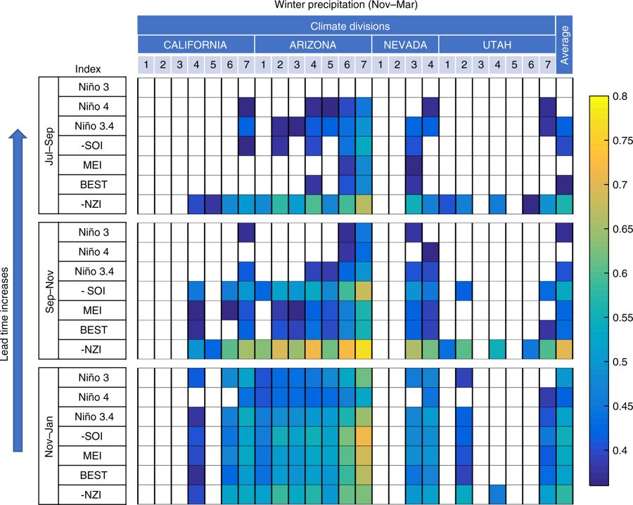 [Comparison of El Nino and NZI teleconnection strengths. Colors illustrate correlation values between precipitation in different climate divisions over SWUS (Nov–Mar) and selected climatological indices corresponding to different 3-month periods, for 1982–2015.]
Climate researchers have traditionally relied on a few planet-spanning oceanic and atmospheric conditions to help them forecast future rainfall. Gradual changes in sea surface temperature in vast regions of the Atlantic and Pacific oceans, jet stream-influencing high-pressure ridges over the Gulf of Alaska, and the familiar El Niño-Southern Oscillation are all players in the precipitation prediction game.
But in recent years, strongly positive El Niño conditions did not bring a lot of rain to California, as they had in the past, while the usually arid state received heavy precipitation in the winter of 2017, considered a neutral El Niño season.
“Predicting drought in the southwestern U.S. is a critical issue for food production and local economies,” said Tom Torgersen, director of the National Science Foundation’s Water Sustainability & Climate program, which funded the research. “The discovery of an interhemispheric bridge that affects the winter U.S. jet stream holds the promise of improved precipitation predictability and drought forecasts.”
Edited for WeatherNation by Meteorologist Mace Michaels
[Comparison of El Nino and NZI teleconnection strengths. Colors illustrate correlation values between precipitation in different climate divisions over SWUS (Nov–Mar) and selected climatological indices corresponding to different 3-month periods, for 1982–2015.]
Climate researchers have traditionally relied on a few planet-spanning oceanic and atmospheric conditions to help them forecast future rainfall. Gradual changes in sea surface temperature in vast regions of the Atlantic and Pacific oceans, jet stream-influencing high-pressure ridges over the Gulf of Alaska, and the familiar El Niño-Southern Oscillation are all players in the precipitation prediction game.
But in recent years, strongly positive El Niño conditions did not bring a lot of rain to California, as they had in the past, while the usually arid state received heavy precipitation in the winter of 2017, considered a neutral El Niño season.
“Predicting drought in the southwestern U.S. is a critical issue for food production and local economies,” said Tom Torgersen, director of the National Science Foundation’s Water Sustainability & Climate program, which funded the research. “The discovery of an interhemispheric bridge that affects the winter U.S. jet stream holds the promise of improved precipitation predictability and drought forecasts.”
Edited for WeatherNation by Meteorologist Mace Michaels
[The New Zealand Index (NZI) teleconnection depends on a western Pacific ocean–atmosphere pathway. a Negative sea surface temperature (SST) anomalies (blue shading) in the NZI region cascade in the northern hemisphere through a late summer interhemispheric atmospheric bridge and are maintained by air-sea coupling until the following winter. The SST anomalies affect the atmospheric pressure in the US west coast and strengthen the regional jet stream which brings more winter storms in the SWUS; b Late-summer positive SST anomalies (red shading) in the NZI region deflect the jet stream to the north, leading to dry conditions over the SWUS]
This prompts a commensurate anomaly east of the Philippine Islands, which, in turn, results in a strengthening or weakening of the jet stream in the Northern Hemisphere, having a direct influence on the amount of rain that falls on California between November and March.
“With the New Zealand Index, we can predict from late summer the likelihood of above- or below-normal winter precipitation in the southwestern U.S., with a correlation in the order of 0.7 – compared to the El Niño-Southern Oscillation technique, which has a correlation around 0.3 to 0.4,” said lead author Antonios Mamalakis, a UCI graduate student in civil & environmental engineering. “Our research also shows an amplification of this newly discovered teleconnection over the past four decades.”
For the study, an interdisciplinary team of scientists analyzed sea surface temperature and atmospheric pressure in 1- and 2-degree cells around the globe from 1950 to 2015.
Mamalakis said the unexpected result was the discovery of persistent sea surface temperature and atmospheric pressure patterns in the southwestern Pacific Ocean that exhibited a strong correlation with precipitation in Southern California, Nevada, Arizona and Utah.
[Comparison of El Nino and NZI teleconnection strengths. Colors illustrate correlation values between precipitation in different climate divisions over SWUS (Nov–Mar) and selected climatological indices corresponding to different 3-month periods, for 1982–2015.]
Climate researchers have traditionally relied on a few planet-spanning oceanic and atmospheric conditions to help them forecast future rainfall. Gradual changes in sea surface temperature in vast regions of the Atlantic and Pacific oceans, jet stream-influencing high-pressure ridges over the Gulf of Alaska, and the familiar El Niño-Southern Oscillation are all players in the precipitation prediction game.
But in recent years, strongly positive El Niño conditions did not bring a lot of rain to California, as they had in the past, while the usually arid state received heavy precipitation in the winter of 2017, considered a neutral El Niño season.
“Predicting drought in the southwestern U.S. is a critical issue for food production and local economies,” said Tom Torgersen, director of the National Science Foundation’s Water Sustainability & Climate program, which funded the research. “The discovery of an interhemispheric bridge that affects the winter U.S. jet stream holds the promise of improved precipitation predictability and drought forecasts.”
Edited for WeatherNation by Meteorologist Mace MichaelsAll Weather News
More
Front Sparks Storms in Texas Oklahoma Through Wednesday
Today brought rounds of severe weather for sp
24 Apr 2024 2:40 AM
Weekend Forecast: More Severe Weather in the Plains
We are looking at the threat of another sever
24 Apr 2024 2:30 AM

Active For The Great Lakes & Northeast
As a low pressure system worked through Tuesd
24 Apr 2024 2:10 AM

NOAA Debuts "HeatRisk" Tool Nationwide
More people die from heat every year than ALL
23 Apr 2024 8:00 PM

Record Warmth to Weekend Snow in the Four Corners
Snow is in the forecast for Denver, which cou
23 Apr 2024 5:25 PM

Double Trouble: Cicadas Take to the Skies this Spring
It’s the soundtrack to the summer. Nature’s n
23 Apr 2024 3:15 PM