NOAA Research Yields Better Lake-Effect Snow Forecasts
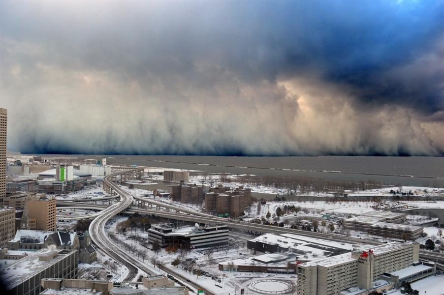
[A wall of intense snowfall desending on the Buffalo Southtowns during the first of two historic back-to-back lake-effect snow events in November 2014. Credit: Shawn Smith, NOAA Weather in Focus Photo Contest 2015]
[NOAA] If you live near the Great Lakes and have to spend any significant time on the road, you’re forgiven if you get a little edgy whenever the forecast calls for lake-effect snow. Lake-effect snowfall is one of the most hazardous weather events in the Great Lakes region, causing prodigious dumps in a short time, often in narrow bands. Knowing where and when the snow will fall can mean the difference between avoiding a challenging drive and getting stuck in a nightmare. To make matters worse, forecasting the timing and amount of snow is extremely challenging.
“Lake-effect snow squalls are very sensitive to the temperature and amount of ice on the underlying lake surface,” said National Weather Service meteorologist Greg Mann, the Science Operations Officer for the Detroit Weather Forecast Office. “Higher surface temperatures will support stronger, more dominant snow bands. Unfortunately, observations over the water are pretty much nonexistent during much of lake-effect season, which hampers the ability of our models to capture important features of the snow squalls. Forecasters have to turn to old rules of thumb and proxies to piece it all together, so you end up with a blurrier forecast.” Ongoing NOAA research promises to change that.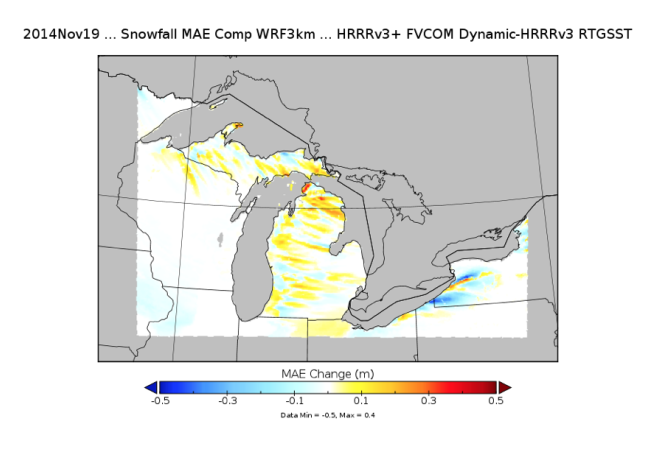 [This figure displays the mean absolute error for snowfall. Blue colors indicates smaller error when using the coupled HRRR-GLOFS model. The coupled model’s snowfall forecast was up to 20 inches more accurate than the operational forecast for that period. Credit: NOAA Global Systems Division]
“COUPLING” TWO NOAA MODELS TO ACHIEVE BETTER SNOW FORECASTS
A new forecast system under development by NOAA scientists at the Great Lakes Environmental Research Laboratory (GLERL) in Ann Arbor, Michigan, together with colleagues at NOAA’s Earth System Research Laboratory (ESRL) in Boulder, Colorado, just passed an important early test. The new approach involves feeding a research version of ESRL’s High-Resolution Rapid Refresh weather forecast model (or HRRR), with better Great Lakes lake-surface temperature and ice data from GLERL’s experimental Great Lakes Operational Forecast System (GLOFS).“GLOFS captures the dynamic physical nature of lake surfaces, which can significantly improve weather forecasts,”said GLERL researcher Eric Anderson.
The HRRR is NOAA’s hourly updating, short-term weather model, and is the most commonly used weather model for predicting lake-effect snow. But the HRRR needs accurate water surface temperatures to properly estimate evaporation rates from lake surfaces, which is the main driver of lake-effect snow.OVERCOMING SATELLITE LIMITATIONS
Unfortunately, satellites have limitations - generally, they can’t see through clouds. If clouds keep satellites from measuring the temperature at a specific location, the HRRR will just use the most recent NOAA-NESDIS lake-temperature estimate. Since it’s especially cloudy during the lake-effect snow season in late fall and early winter, that data could be days old. Lake temperatures can undergo rapid changes at this time of year, so days-old data just doesn’t cut it. That’s where GLOFS comes in. GLOFS uses HRRR outputs —wind, air temperature, pressure, clouds and humidity data to inform predictions of lake surface temperature and ice concentration. So the two models are already linked, or “coupled” - at least in one direction. Researchers are now coupling the models the other way - feeding GLOFS water temperature and ice concentration estimates back into the HRRR. Since GLOFS is also an hourly updating model, the HRRR experiment is always running on the most accurate data available.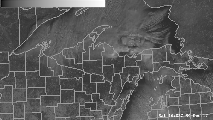 [Visible satellite imagery from GOES-East showing moderate to heavy lake effect snow across Lake Superior on the morning hours of December, 30th, 2017. From NWS Marquette]
NEW APPROACH DEMONSTRATED SKILL DURING “TESTBED” EXPERIMENT
ESRL and GLERL reached a key milestone in late February 2019 when they began to run experimental “coupled” versions of GLOFS and HRRR in real time during the Hydrometeorology Testbed Winter Weather Experiment, run remotely at NOAA’s Weather Prediction Center in College Park, MD. Working with researchers at the University of Michigan’s Cooperative Institute for Great Lakes Research (CIGLR) and the National Weather Service, they saw improvements in HRRR forecasts of lake-effect snow and general forecasts in all seasons over the Great Lakes region. In turn, the improved HRRR forecast outputs are ingested back into GLOFS, leading to more accurate predictions of lake conditions. Mann said the experimental model shows a lot of promise. “We’ve had quite a bit of success during testing through the course of the winter,” he said. “We’ve seen large improvements in representations of coverage, and the intensity has been represented more realistically than we’ve seen in the past.” In one test, researchers used a technique called “retrospective testing,” which involves running meteorological data from a past weather event through the new coupled new model to evaluate how the HRRR-GLOFS system would have performed versus the official forecast - and how accurately it predicted actual observations. The event was the epic November 17 - 19 2014 lake-effect event - one of the most significant winter storms in Buffalo’s snowy history. More than 5 feet of snow fell over areas just east of Buffalo, with mere inches a few miles away to the north.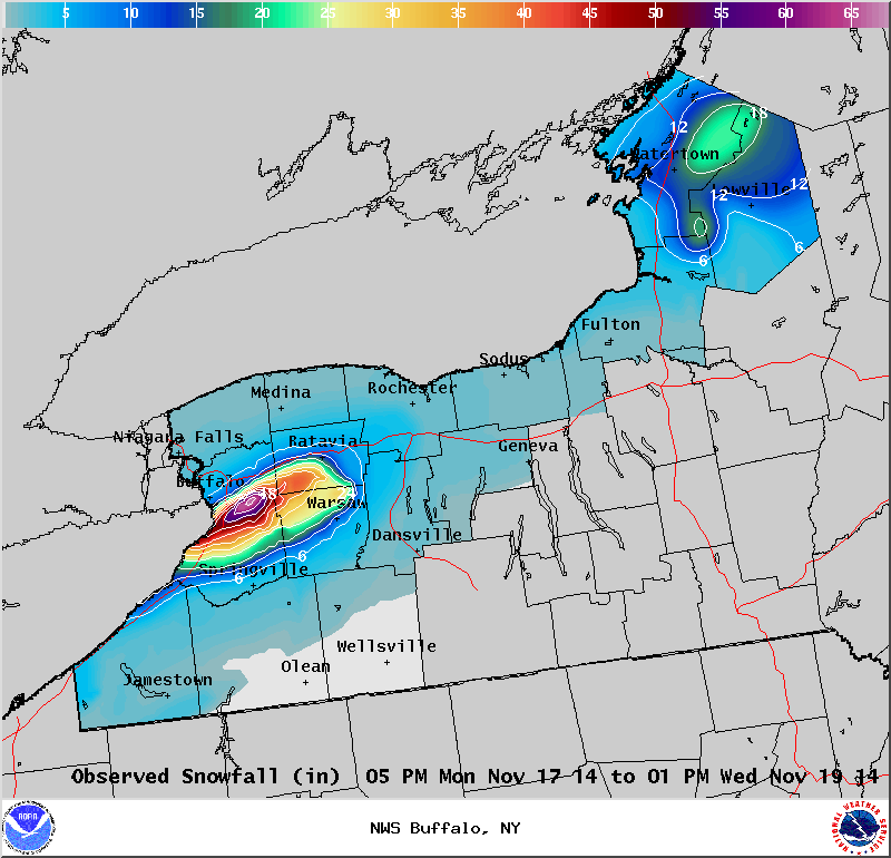 [Observed snowfall from concentrated lake effect snow event on November 17-19, 2014. From NWS Buffalo]
Ingesting GLOFS lake temperature data during the retrospective model run improved the accuracy of HRRR snow-total forecasts by up to 20 inches, ESRL scientists said.
“The goal in the end is to have these higher resolution models that can resolve lake-effect conditions and provide a better, more realistic forecasts,” said Mann. “Certainly there’s more to do, but this is a very good positive step toward improving our forecasts.”
The HRRR-GLOFS coupling is scheduled to be included in the next HRRR model upgrade schedules to be rolled into operation in 2020.
Edited for WeatherNation by Meteorologist Mace Michaels
[Observed snowfall from concentrated lake effect snow event on November 17-19, 2014. From NWS Buffalo]
Ingesting GLOFS lake temperature data during the retrospective model run improved the accuracy of HRRR snow-total forecasts by up to 20 inches, ESRL scientists said.
“The goal in the end is to have these higher resolution models that can resolve lake-effect conditions and provide a better, more realistic forecasts,” said Mann. “Certainly there’s more to do, but this is a very good positive step toward improving our forecasts.”
The HRRR-GLOFS coupling is scheduled to be included in the next HRRR model upgrade schedules to be rolled into operation in 2020.
Edited for WeatherNation by Meteorologist Mace Michaels


