Study Finds that Very Small-Scale Changes in Measured Hurricane Winds Impact Forecasts

Special Stories
2 Feb 2018 1:40 PM
From NOAA HRD
Forecasters and researchers at the National Hurricane Center use the Hurricane Weather Research and Forecasting (HWRF) model to forecast where a hurricane will go, how strong and large it will be, and where the strongest winds will be located in the storm. Wind speeds in hurricanes have been found to be different over very short distances like 300 feet, roughly the length of a football field. This is called the small scale. We have observations of how the wind changes on the small scale from NOAA Hurricane Hunter aircraft. To duplicate these changes, the HWRF model was run a number of times changing how the small-scale wind is forecast to be closest to these observations. The new study documents how these changes improve forecasts of the entire storm.
It was found that small-scale wind features are important for forecasts of how strong the hurricane will get and how quickly, and of its size. The findings will help those creating the forecast models to make future intensity forecasts better.
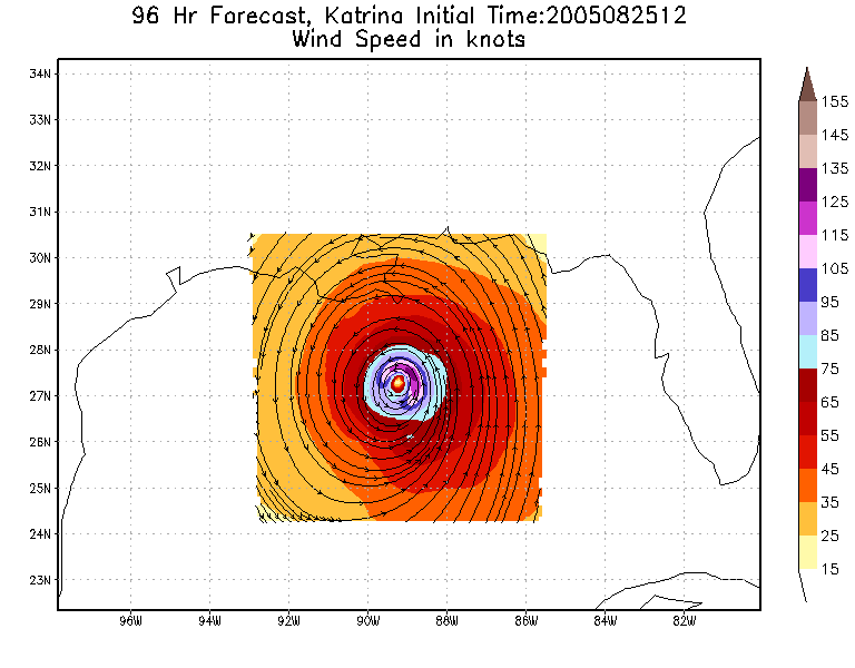 [HWRF 96 hour (4 day) forecast for Hurricane Katrina as it approached New Orleans in 2005]
A previous study in 2015 focused on understanding how the horizontal wind diffusion parameterization worked in the HWRF model and its dynamical influence on hurricane intensification using idealized simulations. A series of sensitivity experiments was conducted to simulate Hurricane Earl (2010). Results from the Earl forecasts confirmed the findings from previous studies, in that both the simulated maximum intensity and intensity change rate are dependent on the small scale wind changes. Comparisons between the modeled and observed structure of Hurricane Earl, such as storm size, surface boundary layer pressure, warm-core temperatures, and eyewall slope, found that small changes in calculations used in the HWRF model should be decreased. This had a positive impact on hurricane prediction based on over 200 retrospective forecasts of 10 Atlantic storms.
[HWRF 96 hour (4 day) forecast for Hurricane Katrina as it approached New Orleans in 2005]
A previous study in 2015 focused on understanding how the horizontal wind diffusion parameterization worked in the HWRF model and its dynamical influence on hurricane intensification using idealized simulations. A series of sensitivity experiments was conducted to simulate Hurricane Earl (2010). Results from the Earl forecasts confirmed the findings from previous studies, in that both the simulated maximum intensity and intensity change rate are dependent on the small scale wind changes. Comparisons between the modeled and observed structure of Hurricane Earl, such as storm size, surface boundary layer pressure, warm-core temperatures, and eyewall slope, found that small changes in calculations used in the HWRF model should be decreased. This had a positive impact on hurricane prediction based on over 200 retrospective forecasts of 10 Atlantic storms.
 [Hurricane Earl near the Bahamas on September 1, 2010]
Improving physical parameterizations in forecast models is essential for hurricane wind speed prediction. The study documents the upgrade of horizontal wind parameterization in the HWRF model and evaluates the impact of this upgrade on hurricane forecasts. The horizontal wind improvements were modified based on aircraft observations and extensive idealized and real-case numerical experiments.
The article, Evaluating the impact of improvement in the horizontal diffusion parameterization on hurricane prediction in the operational Hurricane Weather Research and Forecast (HWRF) model, was published in the Journal of the American Meteorological Society.
Edited for WeatherNation by Meteorologist Mace Michaels
[Hurricane Earl near the Bahamas on September 1, 2010]
Improving physical parameterizations in forecast models is essential for hurricane wind speed prediction. The study documents the upgrade of horizontal wind parameterization in the HWRF model and evaluates the impact of this upgrade on hurricane forecasts. The horizontal wind improvements were modified based on aircraft observations and extensive idealized and real-case numerical experiments.
The article, Evaluating the impact of improvement in the horizontal diffusion parameterization on hurricane prediction in the operational Hurricane Weather Research and Forecast (HWRF) model, was published in the Journal of the American Meteorological Society.
Edited for WeatherNation by Meteorologist Mace Michaels
[HWRF 96 hour (4 day) forecast for Hurricane Katrina as it approached New Orleans in 2005]
A previous study in 2015 focused on understanding how the horizontal wind diffusion parameterization worked in the HWRF model and its dynamical influence on hurricane intensification using idealized simulations. A series of sensitivity experiments was conducted to simulate Hurricane Earl (2010). Results from the Earl forecasts confirmed the findings from previous studies, in that both the simulated maximum intensity and intensity change rate are dependent on the small scale wind changes. Comparisons between the modeled and observed structure of Hurricane Earl, such as storm size, surface boundary layer pressure, warm-core temperatures, and eyewall slope, found that small changes in calculations used in the HWRF model should be decreased. This had a positive impact on hurricane prediction based on over 200 retrospective forecasts of 10 Atlantic storms.
[Hurricane Earl near the Bahamas on September 1, 2010]
Improving physical parameterizations in forecast models is essential for hurricane wind speed prediction. The study documents the upgrade of horizontal wind parameterization in the HWRF model and evaluates the impact of this upgrade on hurricane forecasts. The horizontal wind improvements were modified based on aircraft observations and extensive idealized and real-case numerical experiments.
The article, Evaluating the impact of improvement in the horizontal diffusion parameterization on hurricane prediction in the operational Hurricane Weather Research and Forecast (HWRF) model, was published in the Journal of the American Meteorological Society.
Edited for WeatherNation by Meteorologist Mace MichaelsAll Weather News
More
Soggy, Stormy Weekend in the Southeast
A cold front moved through the Southeast earl
20 Apr 2024 3:00 AM
Wet and Cool Weekend in the Lone Star State
A wet weekend is in store from Oklahoma and T
20 Apr 2024 2:50 AM

National Park Week: Get Out and Explore
National Park Week starts April 20th and runs
19 Apr 2024 8:00 PM

Double Trouble: Cicadas Take to the Skies this Spring
It’s the soundtrack to the summer. Nature’s n
19 Apr 2024 7:50 PM

More Tornadoes and Severe Weather in the Midwest
It has been a busy week as severe weather rip
19 Apr 2024 1:15 PM