Surveying Shipping Hazards After Hurricane Michael
Special Stories
19 Oct 2018 8:35 AM
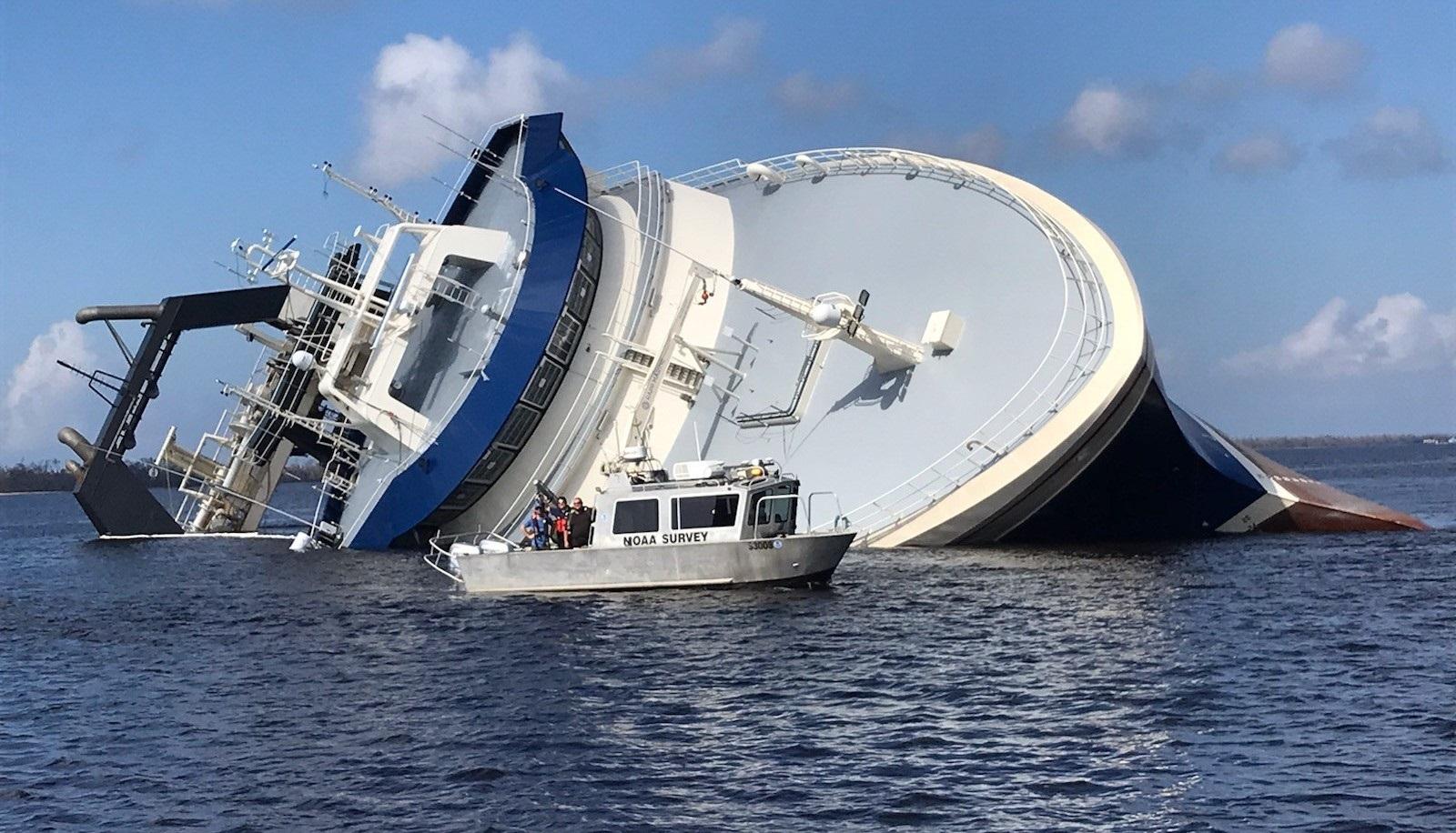
[NRT-Stennis with Alex Ligon, Dan Jacobs, and Josh Bergeron investigate a partially submerged vessel following Hurricane Michael. Credit: Lt. j.g. Michelle Levano]
[NOAA] After quickly gaining the strength of a Category 4 storm, Hurricane Michael reached the panhandle of Florida on Wednesday, October 10. With maximum sustained winds of 155 mph and storm surge reaching 15 feet, this storm wiped out coastal communities and closed ports to all traffic in the area. Dangerous winds and storm surge can shift sands and pull large objects beneath the waves, creating hazards to navigation. Before ports can reopen and safely resume vessel traffic, the U.S. Coast Guard must be aware of any underwater dangers so they can either be properly charted or removed.
 [NRT-Fernandina Beach survey the area surrounding the sunken vessel for shoaling.]
As Hurricane Michael approached Florida, NOAA’s western Gulf Coast navigation manager, Tim Osborn, embedded with the Maritime Transportation System Recovery Unit (MTSRU) in Mobile, Alabama, to engage with U.S. Army Corps of Engineers and the U.S. Coast Guard on storm preparations and coordination of NOAA’s navigation response teams (NRT) if needed. The two nearby response teams remained response ready and rode out the storm at their respective home ports at Stennis Space Center, Mississippi, and Fernandina Beach, Florida. NRTs are three-person crews with small vessels that are strategically located around the country and remain on call to respond to emergencies, speeding the resumption of shipping after storms, and protecting life and property from underwater dangers to navigation.
[NRT-Fernandina Beach survey the area surrounding the sunken vessel for shoaling.]
As Hurricane Michael approached Florida, NOAA’s western Gulf Coast navigation manager, Tim Osborn, embedded with the Maritime Transportation System Recovery Unit (MTSRU) in Mobile, Alabama, to engage with U.S. Army Corps of Engineers and the U.S. Coast Guard on storm preparations and coordination of NOAA’s navigation response teams (NRT) if needed. The two nearby response teams remained response ready and rode out the storm at their respective home ports at Stennis Space Center, Mississippi, and Fernandina Beach, Florida. NRTs are three-person crews with small vessels that are strategically located around the country and remain on call to respond to emergencies, speeding the resumption of shipping after storms, and protecting life and property from underwater dangers to navigation.
 [NRT-Fernandina Beach’s Howie Meyers (ERT) (left) and James Kirkpatrick (right) survey near Panama City, Florida, searching for Navy ship anchors lost during Hurricane Michael.]
Once the storm passed through the panhandle, the teams departed their home ports with food, surplus fuel, and spare boat parts. NRT-Stennis deployed to Pensacola, Florida, with team members Alex Ligon, Joshua Bergeron, and Dan Jacobs (augmenting from NRT-Galveston, Texas) on October 11. The Army Corps of Engineers and Coast Guard MTSRU requested the Pensacola survey to ensure the port was open and available for vessels diverted from the storm. The team surveyed that afternoon and completed survey operations in Pensacola on October 13.
[NRT-Fernandina Beach’s Howie Meyers (ERT) (left) and James Kirkpatrick (right) survey near Panama City, Florida, searching for Navy ship anchors lost during Hurricane Michael.]
Once the storm passed through the panhandle, the teams departed their home ports with food, surplus fuel, and spare boat parts. NRT-Stennis deployed to Pensacola, Florida, with team members Alex Ligon, Joshua Bergeron, and Dan Jacobs (augmenting from NRT-Galveston, Texas) on October 11. The Army Corps of Engineers and Coast Guard MTSRU requested the Pensacola survey to ensure the port was open and available for vessels diverted from the storm. The team surveyed that afternoon and completed survey operations in Pensacola on October 13.
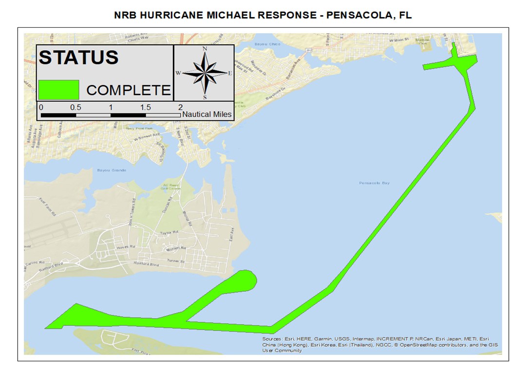 [NRT priority areas and completion status in Pensacola, Florida.]
Additional personnel including Patrick Debroisse, junior officer in charge of Bay Hydro II in Solomons, Maryland, Tim Wilkinson, team member of the NRT-Seattle, and Julia Wallace (ERT) from NOAA Office of Coast Survey’s Atlantic Hydrographic Branch in Norfolk, Virginia, were also mobilized to Pensacola to provide shore-side survey and data processing support for the response effort. The processing support then deployed to Panama City, Florida, on October 12 to produce data products for the MTSRU, state of Florida, Panama City, and U.S. Coast Guard.
[NRT priority areas and completion status in Pensacola, Florida.]
Additional personnel including Patrick Debroisse, junior officer in charge of Bay Hydro II in Solomons, Maryland, Tim Wilkinson, team member of the NRT-Seattle, and Julia Wallace (ERT) from NOAA Office of Coast Survey’s Atlantic Hydrographic Branch in Norfolk, Virginia, were also mobilized to Pensacola to provide shore-side survey and data processing support for the response effort. The processing support then deployed to Panama City, Florida, on October 12 to produce data products for the MTSRU, state of Florida, Panama City, and U.S. Coast Guard.
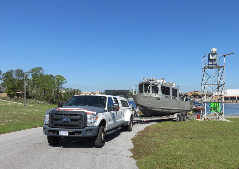 [NRT-Stennis deploys the boat at U.S. Coast Guard Base Panama City on October 13 after finishing the Peninsula survey. Credit: Lt. j.g. Patrick Debroisse]
NRT-Fernandina Beach with team lead James Kirkpatrick, team member Howie Meyers (ERT), and Lt. j.g. Michelle Levano (augmenting from NRT-Seattle) mobilized directly to Panama City on October 11. The team surveyed the morning of October 12 on priority areas requested by the Coast Guard MTSRU. Designated high priority areas included the approaches to U.S. Navy and Coast Guard bases in Alligator Bayou, the Port of Panama City, Chevron Terminal, and the primary waterways through St Andrews Bay and West Bay.
[NRT-Stennis deploys the boat at U.S. Coast Guard Base Panama City on October 13 after finishing the Peninsula survey. Credit: Lt. j.g. Patrick Debroisse]
NRT-Fernandina Beach with team lead James Kirkpatrick, team member Howie Meyers (ERT), and Lt. j.g. Michelle Levano (augmenting from NRT-Seattle) mobilized directly to Panama City on October 11. The team surveyed the morning of October 12 on priority areas requested by the Coast Guard MTSRU. Designated high priority areas included the approaches to U.S. Navy and Coast Guard bases in Alligator Bayou, the Port of Panama City, Chevron Terminal, and the primary waterways through St Andrews Bay and West Bay.
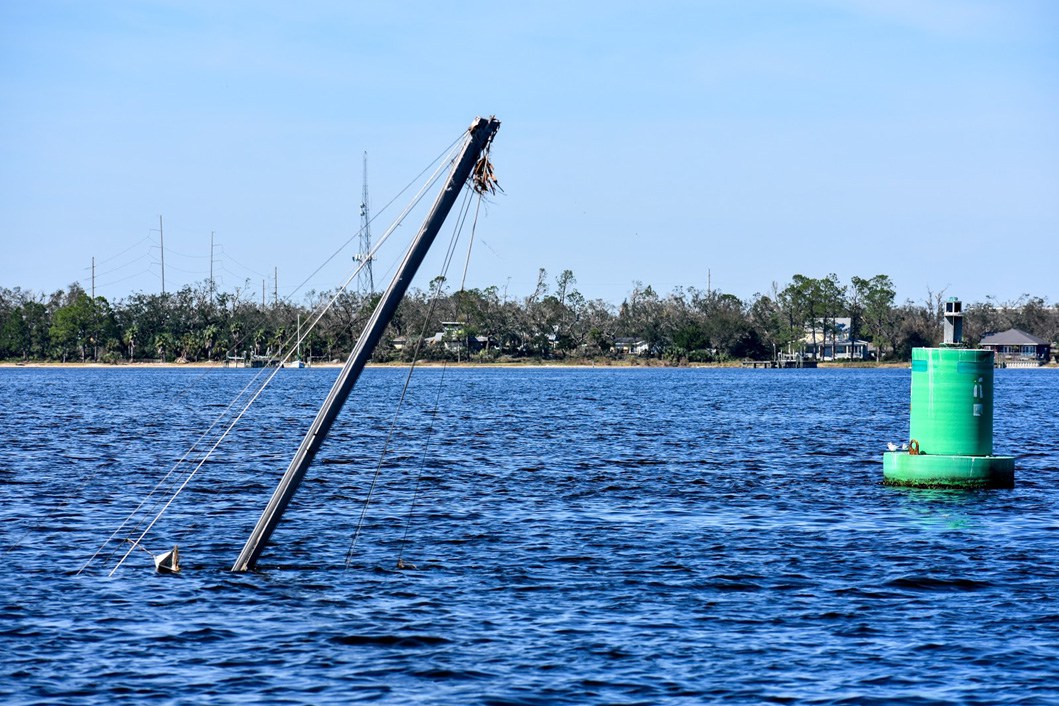
 [Possible danger to navigation located near a Coast Guard dock in Alligator Bayou, found by NRT-Fernandina Beach.]
The team also searched for the USS Sea Fighter’s two anchors, which were lost while the ship weathered out the storm at anchor, as well as three range towers for the Coast Guard. While servicing aids to navigation in St. Andrews Bay, the Coast Guard discovered that three ranges towers were missing. The Coast Guard hailed NOAA’s NRT on VHF and requested assistance in locating the missing towers. The team located the back tower for lighted Range “A,” which the Coast Guard recovered, and a tower for lighted Range “B.” Lighted ranges and markers are a pair of aligned large rectangular boards, one higher than the other, that when vertically aligned, guide vessels though the channel and indicate if a ship is on course.
[Possible danger to navigation located near a Coast Guard dock in Alligator Bayou, found by NRT-Fernandina Beach.]
The team also searched for the USS Sea Fighter’s two anchors, which were lost while the ship weathered out the storm at anchor, as well as three range towers for the Coast Guard. While servicing aids to navigation in St. Andrews Bay, the Coast Guard discovered that three ranges towers were missing. The Coast Guard hailed NOAA’s NRT on VHF and requested assistance in locating the missing towers. The team located the back tower for lighted Range “A,” which the Coast Guard recovered, and a tower for lighted Range “B.” Lighted ranges and markers are a pair of aligned large rectangular boards, one higher than the other, that when vertically aligned, guide vessels though the channel and indicate if a ship is on course.
 [Sunken sailboat found by NRT-Fernandina Beach while surveying off Bear Pt., just outside the channel in Panama City. Credit: Howie Meyers (ERT)]
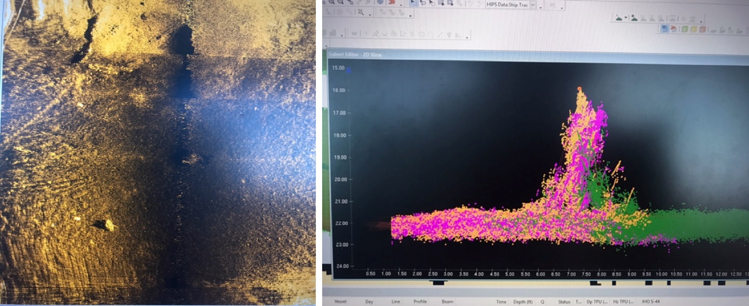
NOAA’s navigation response team vessels conduct object detection surveys with 200% seafloor coverage using side scan sonar and concurrent high-resolution bathymetry with multibeam echo sounders. The data collected with these surveys complements the Army Corps single beam survey efforts in federally maintained channels and surrounding areas.
In addition to surveying, NRT-Fernandina Beach investigated a tide gauge for NOAA’s Center for Operational Oceanographic Products and Services in Panama City.
[Sunken sailboat found by NRT-Fernandina Beach while surveying off Bear Pt., just outside the channel in Panama City. Credit: Howie Meyers (ERT)]
NOAA’s navigation response team vessels conduct object detection surveys with 200% seafloor coverage using side scan sonar and concurrent high-resolution bathymetry with multibeam echo sounders. The data collected with these surveys complements the Army Corps single beam survey efforts in federally maintained channels and surrounding areas.
In addition to surveying, NRT-Fernandina Beach investigated a tide gauge for NOAA’s Center for Operational Oceanographic Products and Services in Panama City.
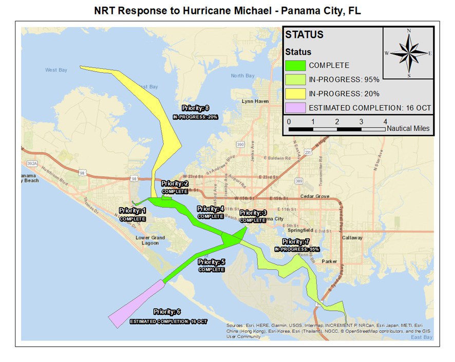 [Navigation response team priority areas and completion status in Panama City.]
With power outage challenges and spotty internet coverage throughout the devastated areas, both response teams continue to collect and process survey data the most efficient way possible for delivery to the MTSRU. In some instances, potential dangers to navigation are submitted via multimedia messages to shore for relay to the Coast Guard MTSRU. NOAA Office of Coast Survey’s Navigation Response Branch is compiling a list of potential dangers to navigation and are working with Coast Guard, Army Corps, and port partners to ensure these items are either salvaged or submitted to Coast Survey’s Nautical Data Branch as Dangers to Navigation and then distributed to mariners via the weekly electronic navigation chart updates.
Edited for WeatherNation by Meteorologist Mace Michaels
[Navigation response team priority areas and completion status in Panama City.]
With power outage challenges and spotty internet coverage throughout the devastated areas, both response teams continue to collect and process survey data the most efficient way possible for delivery to the MTSRU. In some instances, potential dangers to navigation are submitted via multimedia messages to shore for relay to the Coast Guard MTSRU. NOAA Office of Coast Survey’s Navigation Response Branch is compiling a list of potential dangers to navigation and are working with Coast Guard, Army Corps, and port partners to ensure these items are either salvaged or submitted to Coast Survey’s Nautical Data Branch as Dangers to Navigation and then distributed to mariners via the weekly electronic navigation chart updates.
Edited for WeatherNation by Meteorologist Mace Michaels
[NRT-Fernandina Beach survey the area surrounding the sunken vessel for shoaling.]
As Hurricane Michael approached Florida, NOAA’s western Gulf Coast navigation manager, Tim Osborn, embedded with the Maritime Transportation System Recovery Unit (MTSRU) in Mobile, Alabama, to engage with U.S. Army Corps of Engineers and the U.S. Coast Guard on storm preparations and coordination of NOAA’s navigation response teams (NRT) if needed. The two nearby response teams remained response ready and rode out the storm at their respective home ports at Stennis Space Center, Mississippi, and Fernandina Beach, Florida. NRTs are three-person crews with small vessels that are strategically located around the country and remain on call to respond to emergencies, speeding the resumption of shipping after storms, and protecting life and property from underwater dangers to navigation.
[NRT-Fernandina Beach’s Howie Meyers (ERT) (left) and James Kirkpatrick (right) survey near Panama City, Florida, searching for Navy ship anchors lost during Hurricane Michael.]
Once the storm passed through the panhandle, the teams departed their home ports with food, surplus fuel, and spare boat parts. NRT-Stennis deployed to Pensacola, Florida, with team members Alex Ligon, Joshua Bergeron, and Dan Jacobs (augmenting from NRT-Galveston, Texas) on October 11. The Army Corps of Engineers and Coast Guard MTSRU requested the Pensacola survey to ensure the port was open and available for vessels diverted from the storm. The team surveyed that afternoon and completed survey operations in Pensacola on October 13.
[NRT priority areas and completion status in Pensacola, Florida.]
Additional personnel including Patrick Debroisse, junior officer in charge of Bay Hydro II in Solomons, Maryland, Tim Wilkinson, team member of the NRT-Seattle, and Julia Wallace (ERT) from NOAA Office of Coast Survey’s Atlantic Hydrographic Branch in Norfolk, Virginia, were also mobilized to Pensacola to provide shore-side survey and data processing support for the response effort. The processing support then deployed to Panama City, Florida, on October 12 to produce data products for the MTSRU, state of Florida, Panama City, and U.S. Coast Guard.
[NRT-Stennis deploys the boat at U.S. Coast Guard Base Panama City on October 13 after finishing the Peninsula survey. Credit: Lt. j.g. Patrick Debroisse]
NRT-Fernandina Beach with team lead James Kirkpatrick, team member Howie Meyers (ERT), and Lt. j.g. Michelle Levano (augmenting from NRT-Seattle) mobilized directly to Panama City on October 11. The team surveyed the morning of October 12 on priority areas requested by the Coast Guard MTSRU. Designated high priority areas included the approaches to U.S. Navy and Coast Guard bases in Alligator Bayou, the Port of Panama City, Chevron Terminal, and the primary waterways through St Andrews Bay and West Bay.
[Possible danger to navigation located near a Coast Guard dock in Alligator Bayou, found by NRT-Fernandina Beach.]
The team also searched for the USS Sea Fighter’s two anchors, which were lost while the ship weathered out the storm at anchor, as well as three range towers for the Coast Guard. While servicing aids to navigation in St. Andrews Bay, the Coast Guard discovered that three ranges towers were missing. The Coast Guard hailed NOAA’s NRT on VHF and requested assistance in locating the missing towers. The team located the back tower for lighted Range “A,” which the Coast Guard recovered, and a tower for lighted Range “B.” Lighted ranges and markers are a pair of aligned large rectangular boards, one higher than the other, that when vertically aligned, guide vessels though the channel and indicate if a ship is on course.
[Sunken sailboat found by NRT-Fernandina Beach while surveying off Bear Pt., just outside the channel in Panama City. Credit: Howie Meyers (ERT)]
NOAA’s navigation response team vessels conduct object detection surveys with 200% seafloor coverage using side scan sonar and concurrent high-resolution bathymetry with multibeam echo sounders. The data collected with these surveys complements the Army Corps single beam survey efforts in federally maintained channels and surrounding areas.
In addition to surveying, NRT-Fernandina Beach investigated a tide gauge for NOAA’s Center for Operational Oceanographic Products and Services in Panama City.
[Navigation response team priority areas and completion status in Panama City.]
With power outage challenges and spotty internet coverage throughout the devastated areas, both response teams continue to collect and process survey data the most efficient way possible for delivery to the MTSRU. In some instances, potential dangers to navigation are submitted via multimedia messages to shore for relay to the Coast Guard MTSRU. NOAA Office of Coast Survey’s Navigation Response Branch is compiling a list of potential dangers to navigation and are working with Coast Guard, Army Corps, and port partners to ensure these items are either salvaged or submitted to Coast Survey’s Nautical Data Branch as Dangers to Navigation and then distributed to mariners via the weekly electronic navigation chart updates.
Edited for WeatherNation by Meteorologist Mace MichaelsAll Weather News
More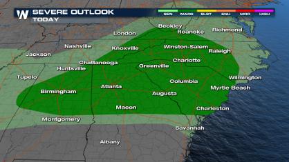
Storms in the Southeast Friday, More this Weekend
Energy and moisture move along a cold front i
19 Apr 2024 5:40 PM
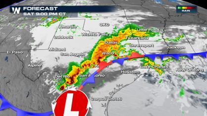
Wet and Cool Weekend in the Lone Star State
We're looking at a wet end of the week for th
19 Apr 2024 5:35 PM
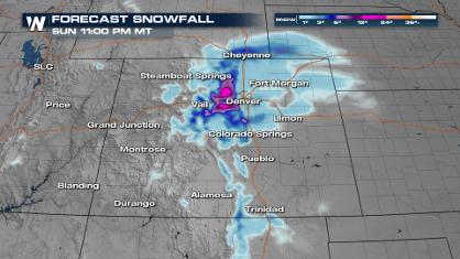
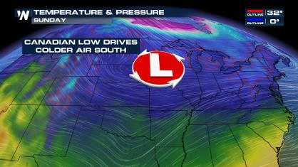
Frosty Start Friday Morning in the Plains
Colder air has arrived in the High Plains tha
19 Apr 2024 2:05 PM

National Park Week: Get Out and Explore
National Park Week starts April 20th and runs
19 Apr 2024 2:00 PM

Double Trouble: Cicadas Take to the Skies this Spring
It’s the soundtrack to the summer. Nature’s n
19 Apr 2024 1:30 PM

More Tornadoes and Severe Weather in the Midwest
It has been a busy week as severe weather rip
19 Apr 2024 1:15 PM