Explaining Straight Line Winds
Top Stories
8 Jul 2020 7:00 PM
https://youtu.be/ey-032W0t3c
When there’s a threat for severe thunderstorms for your area, the most common danger is straight-line winds, also known as downbursts.
The process starts with air rising within the strong updraft of a storm. It then cools, condenses, and as a result tiny drops of water form.
The droplets increase in size and then combine with others, eventually becoming too heavy. Then, these droplets fall toward the surface within a pocket of cold air.
https://twitter.com/i/status/1269396901574524928
After the air hits the ground, it compresses and forces the winds to increase very quickly outward sometimes exceeding 165 miles per hour!
Damaging winds come in many different forms including small scale microbursts, broad spanning derechos, and even haboobs associated with drier thunderstorms.
https://twitter.com/i/status/1015059936554831872
Downbursts are different from winds associated with a tornado. Instead of winds flowing out of the storm, with a tornado winds flow into it. After the storm, local national weather service offices will conduct storm surveys to look for circulation to determine if it was a straight line wind event or a tornado.
https://twitter.com/i/status/996942974368935937
But remember – it’s not the wind itself that can be deadly, it is what is in the wind that’s dangerous. That’s why it’s always important to stay weather aware and be prepared whenever severe weather threatens your community.
https://twitter.com/i/status/1248377651879759874
All Weather News
More
More than 5M Under Tornado Threat in the Midwest
The severe storm threat shifts into Iowa and
16 Apr 2024 5:30 PM
Looking Ahead: Midweek Severe Threat
As we've already seen in the past few days, t
16 Apr 2024 4:45 PM

Potential Record Heat from the Plains to Southeast
Multiple records were tied and broken across
16 Apr 2024 3:05 PM

Double Trouble: Cicadas Take to the Skies this Spring
It’s the soundtrack to the summer. Nature’s n
16 Apr 2024 1:10 PM
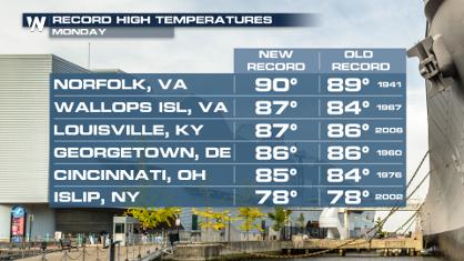
Record Highs and Hail in the Middle Atlantic Monday
Monday was a hot day across the northeast and
16 Apr 2024 12:30 PM