Sorry, Groundhog: Winter and February Were Warmer than Average
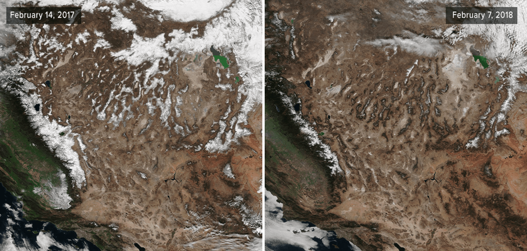
[So far this year, snow levels across the Southwest — in particular the Sierra Nevada mountains and Southern Rockies — have been below average and much lower than those seen in 2017. The Northern Rockies, however, experienced a cold and wet February and winter, which led to record-high mountain snowpack in some areas. Images from the Suomi NPP satellite via NOAA Satellite and Information Service.]
From NOAA
In a “prediction” that mirrored last year, Punxsutawney Phil, the famous furry forecaster, saw his shadow in early February and as the legend goes, supposedly six more weeks of winter for the U.S. Unfortunately for Phil, his forecast has not been supported by the climate record, so far.
A warmer-than-average February in many parts of the country helped boost winter temperatures across much of the West and along the East Coast, bringing spring and even summer-like conditions in some spots. This contrasted with cooler-than-average conditions in the Northern High and Central Plains.
Here’s how February and meteorological winter 2018 fared in terms of the climate record:
Climate by the numbers
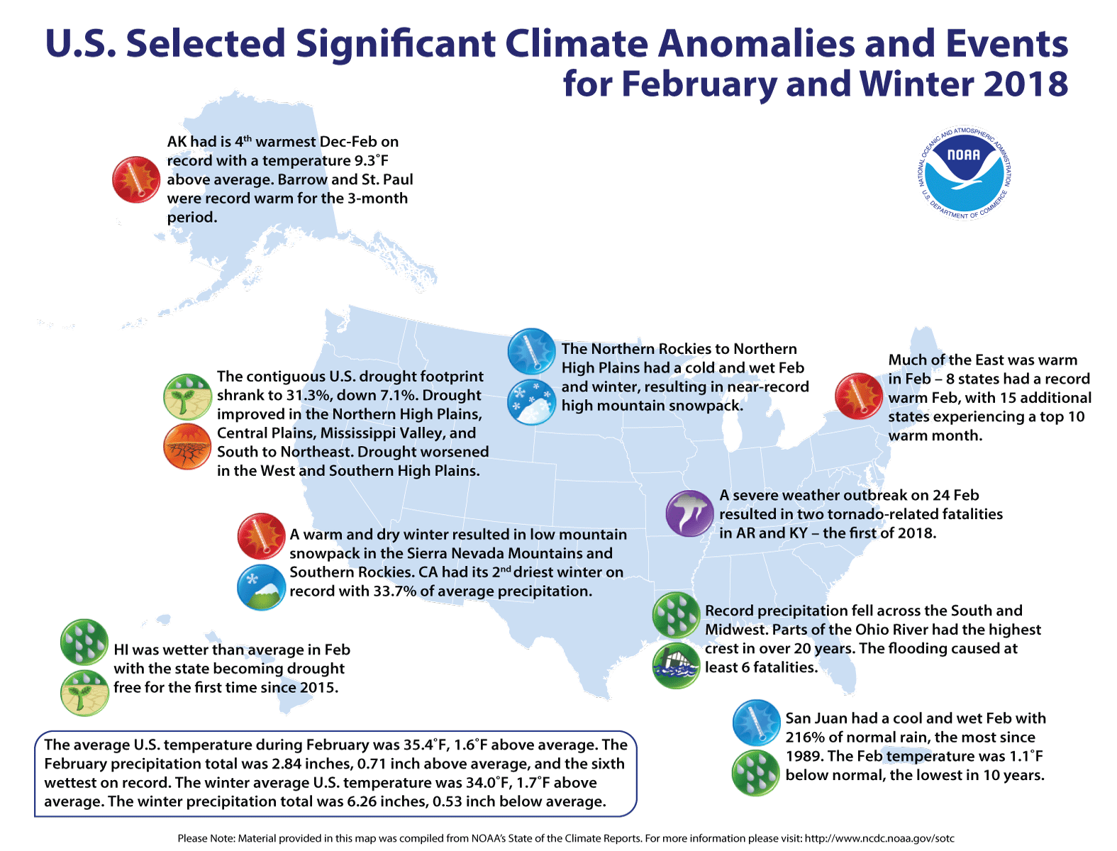
Winter season | December 2017 through February 2018
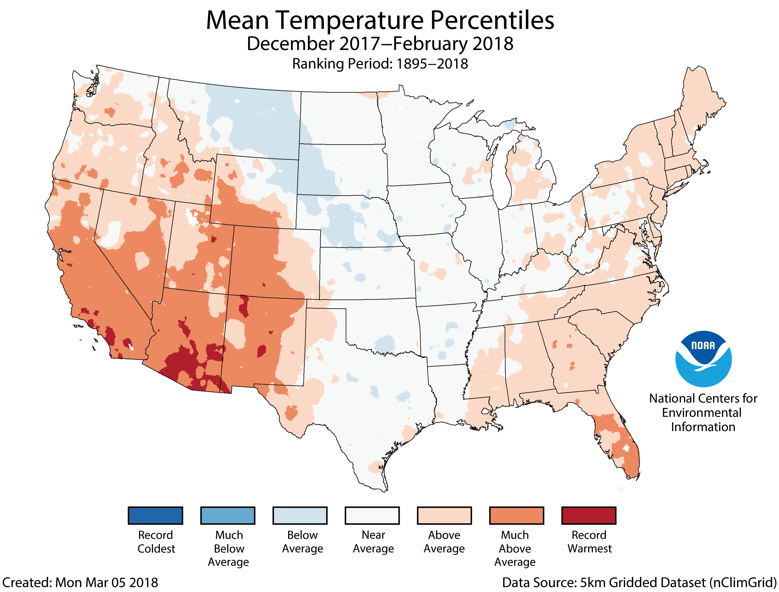
The average temperature during meteorological winter for the contiguous U.S. was 34.0 degrees F, 1.7 degrees above average, ranking it among the warmest third in the 124-year record, according to scientists from NOAA’s National Centers for Environmental Information. Much of the East Coast and West had a warmer-than-average winter.
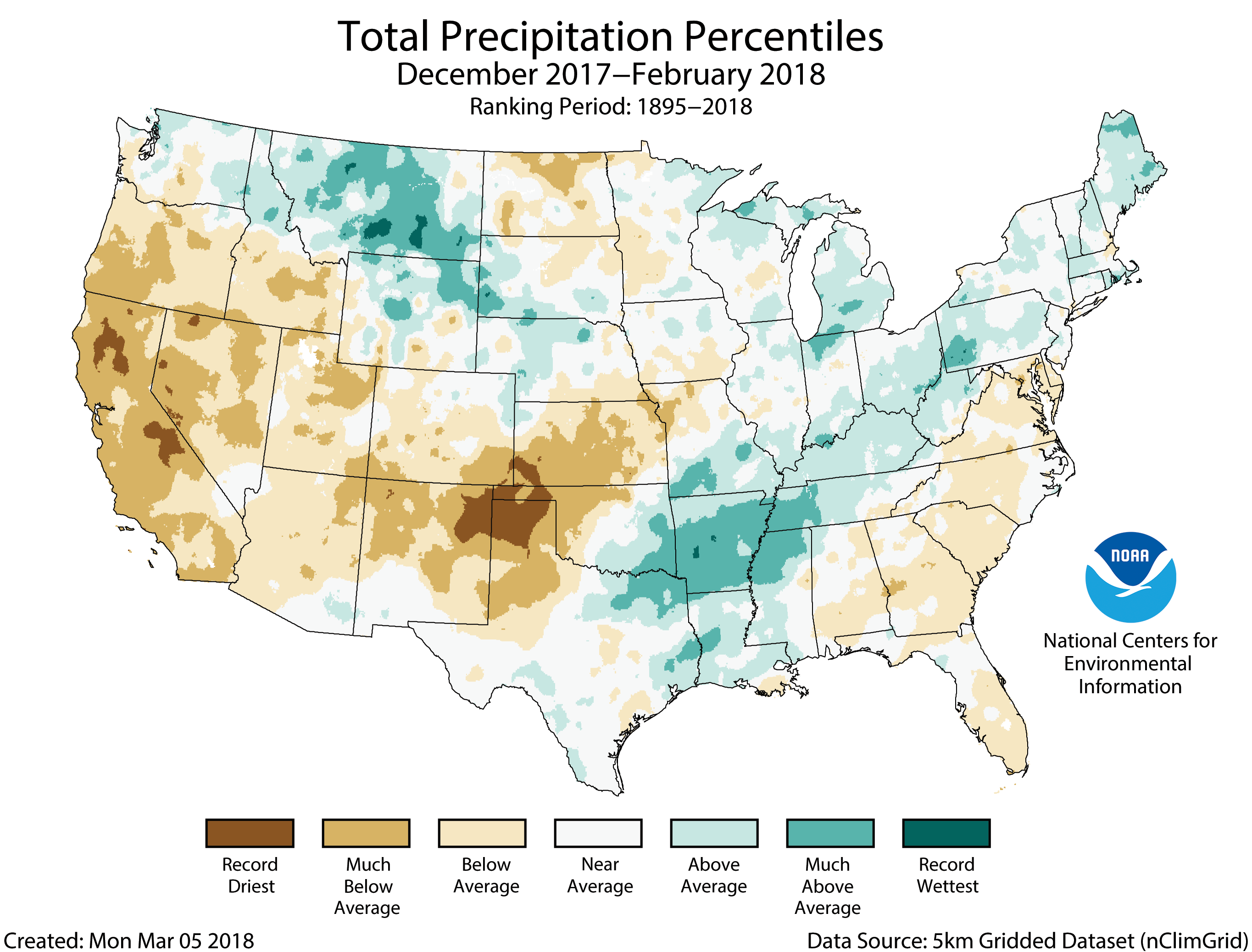
The average precipitation total for this winter was 6.26 inches, a 0.53 inch below average, ranking among the driest third in the record. The season was marked by regional precipitation extremes: Large areas of the West, Plains and Southeast were drier than average, while the Northern Rockies, Midwest and Lower-Mississippi Valley were wetter than average.
February 2018
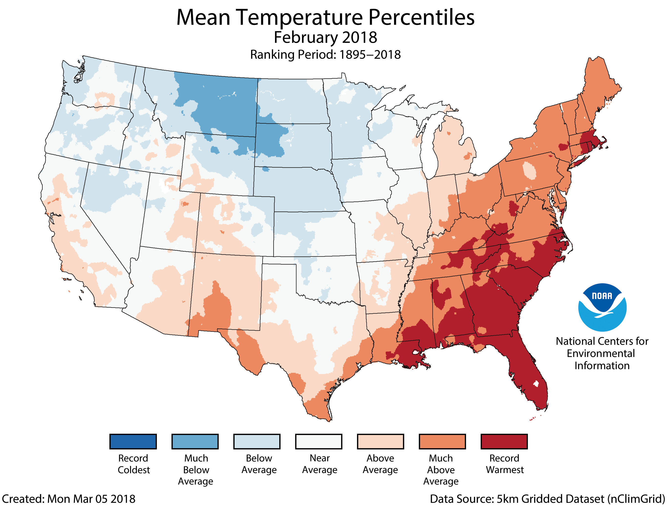
The average temperature for the contiguous U.S. in February was 35.4 degrees F, 1.6 degrees above average, ranking among the warmest third. Abnormally warm conditions spanned the East and parts of the Southwest, with below-average temperatures in the Northern Rockies and the Great Plains.
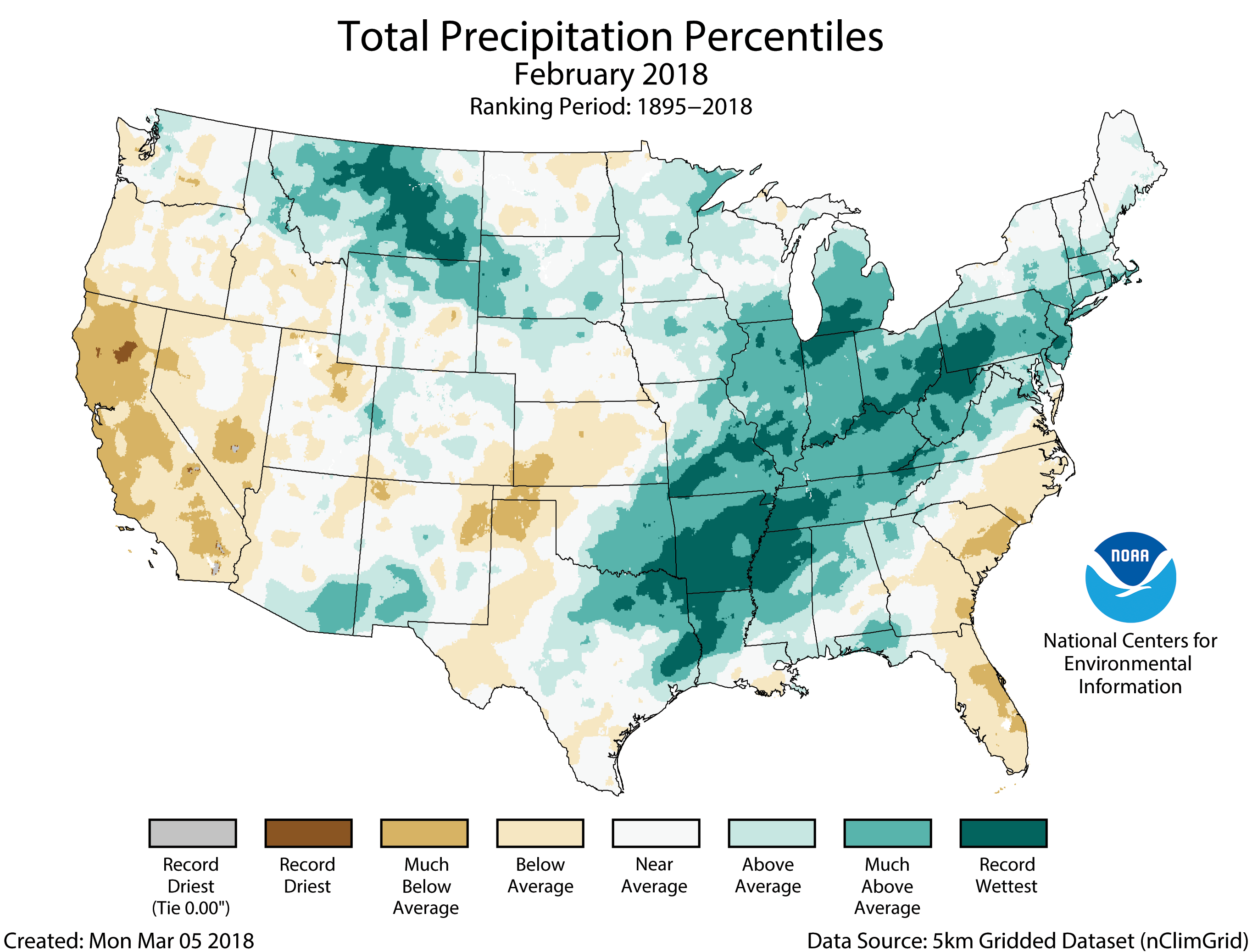
The precipitation total for the month was 2.84 inches, 0.71 of an inch above average, making it the sixth wettest February on record, the wettest since 1998. Record precipitation fell over a large part of the central U.S., yet parts of the West, Central Plains and Southeast were drier than average.
More notable climate events
-
Record-warm February in the East: Eight states had a record warm February, with 15 additional states experiencing a Top-10 warm month ranking.
-
Heavy snow in the Northern Rockies: The Northern Rockies had a cold and wet February and winter, which led to record-high mountain snowpack in some areas. Montana had its sixth coldest February on record with a monthly temperature 9.7 degrees F below average, and had its fourth wettest February on record, receiving more than double the average precipitation.
-
Record flooding in the Midwest and South: Record precipitation fell across the South and Midwest in February. Six states were record wet, including Arkansas, Missouri, Tennessee, Illinois, Indiana and Pennsylvania. Parts of the Ohio River experienced record flooding, causing at least six deaths.
-
Warm and dry in the Southwest: A warm and dry winter resulted in low mountain snowpack in the Sierra Nevada Mountains and Southern Rockies. California had its second driest winter on record with 33.7 percent of average precipitation, the driest since 1976/1977.
-
Another warm winter for Alaskans: The average winter temperature in Alaska was 12.9 degrees F, 9.3 degrees above average. Much-above-average temperatures spanned the state, with record warmth along the North Slope. Barrow and St. Paul were record warm for the 3-month period.
-
Drought expanded in the West: By the end of February, 31.3 percent of the contiguous U.S. was in drought, down 7.1 percent from the end of January. Drought improved in the Northern High Plains, Central Plains, Mississippi Valley, and South to Northeast. Drought worsened in the West and Southern High Plains.