State of Emergency Issued Ahead of Alberto
Special Stories
26 May 2018 9:45 AM
 The state of Florida has declared a state of emergency in anticipation of the affects from Alberto.
On Saturday morning, Governor Rick Scott made the statement covering all 67 Florida counties as the state continues to monitor and prepare for Subtropical Storm Alberto. By declaring this state of emergency, Governor Scott is ensuring that state and local government has ample time, resources and flexibility to get prepared for this storm.
The state of Florida has declared a state of emergency in anticipation of the affects from Alberto.
On Saturday morning, Governor Rick Scott made the statement covering all 67 Florida counties as the state continues to monitor and prepare for Subtropical Storm Alberto. By declaring this state of emergency, Governor Scott is ensuring that state and local government has ample time, resources and flexibility to get prepared for this storm.
 Governor Scott said, “As we continue to monitor Subtropical Storm
Alberto’s northward path toward Florida, it is critically important that all Florida counties have every available resource to keep families safe and prepare for the torrential rain and severe flooding this storm will bring."
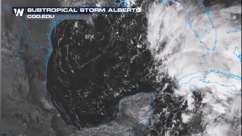
Flood watches have been issued for Florida with 3-5" of rain expected widespread, with locally high amounts. This comes on top of a very wet 2 weeks past for the Sunshine state. Key West, FL set a monthly record for rainfall for May (click for story)
Governor Scott said, “As we continue to monitor Subtropical Storm
Alberto’s northward path toward Florida, it is critically important that all Florida counties have every available resource to keep families safe and prepare for the torrential rain and severe flooding this storm will bring."
Flood watches have been issued for Florida with 3-5" of rain expected widespread, with locally high amounts. This comes on top of a very wet 2 weeks past for the Sunshine state. Key West, FL set a monthly record for rainfall for May (click for story)
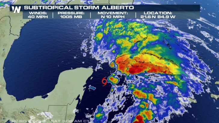
 The latest on Subtropical Storm Alberto as of Saturday morning from the National Hurricane Center.
Subtropical Storm Alberto Advisory Number 5
NWS National Hurricane Center Miami FL AL012018
1100 AM EDT Sat May 26 2018
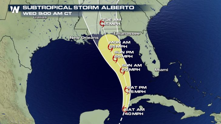
...ALBERTO FORECAST TO STRENGTHEN WHILE MOVING NORTHWARD OVER THE
GULF OF MEXICO...
...HEAVY RAINFALL EXPECTED TO AFFECT WESTERN CUBA...FLORIDA...AND
THE NORTHEASTERN GULF COAST THROUGH THE WEEKEND...
SUMMARY OF 1100 AM EDT...1500 UTC...INFORMATION
-----------------------------------------------
LOCATION...21.6N 84.9W
ABOUT 20 MI...35 KM S OF THE WESTERN TIP OF CUBA
ABOUT 250 MI...400 KM SSW OF THE DRY TORTUGAS
MAXIMUM SUSTAINED WINDS...40 MPH...65 KM/H
PRESENT MOVEMENT...N OR 10 DEGREES AT 10 MPH...17 KM/H
MINIMUM CENTRAL PRESSURE...1005 MB...29.68 INCHES
HAZARDS AFFECTING LAND
----------------------
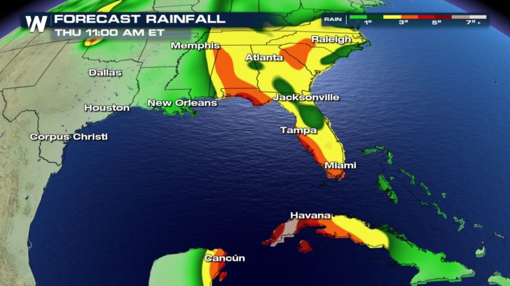
RAINFALL: Alberto is expected to produce total rain accumulations
of 10 to 15 inches with isolated totals of 25 inches across western
Cuba. These rains could produce life-threatening flash floods and
mudslides. Rainfall accumulations of 3 to 7 inches with maximum
amounts of 10 inches are possible across the Florida Keys and
southern and southwest Florida. Heavy rains will begin to affect
the central Gulf Coast region into the southeastern United States on
Sunday and continue into the middle of next week as Alberto moves
northward after landfall. Rainfall totals of 5 to 10 inches with
maximum amounts of 15 inches are possible along the track of Alberto
from eastern Louisiana, across much of Mississippi, Alabama, western
Tennessee and the western Florida panhandle. Rainfall totals of 3
to 5 inches with maximum totals of 8 inches possible from the
southern Appalachians into the coastal southeast.
WIND: Tropical storm conditions are expected within portions of the
warning area in Cuba through this evening. Tropical storm
conditions are expected in the Dry Tortugas later today and tonight.
Tropical storm conditions are possible in the watch area along the
Florida west coast on Sunday, and along the northern Gulf Coast
by Sunday night or early Monday.
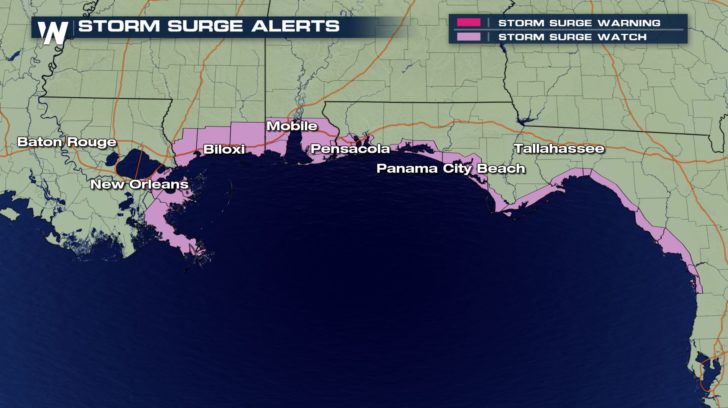
STORM SURGE: The combination of storm surge and the tide will cause
normally dry areas near the coast to be flooded by rising waters
moving inland from the shoreline. The water could reach the
following heights above ground somewhere in the indicated
areas if the peak surge occurs at the time of high tide...
TORNADOES: A tornado or two may occur over the Florida Keys and
parts of southwestern Florida late this afternoon through tonight.
SURF: Swells generated by Alberto are affecting portions of the
coast of eastern Yucatan Peninsula and western Cuba. These swells
are likely to cause life-threatening surf and rip current
conditions. Hazardous surf conditions are likely to develop along
much of the central and eastern U.S. Gulf Coast through the weekend.
For more information, consult products from your local weather
office.
NEXT ADVISORY
-------------
Next intermediate advisory at 200 PM EDT.
Next complete advisory at 500 PM EDT.
The latest on Subtropical Storm Alberto as of Saturday morning from the National Hurricane Center.
Subtropical Storm Alberto Advisory Number 5
NWS National Hurricane Center Miami FL AL012018
1100 AM EDT Sat May 26 2018
...ALBERTO FORECAST TO STRENGTHEN WHILE MOVING NORTHWARD OVER THE
GULF OF MEXICO...
...HEAVY RAINFALL EXPECTED TO AFFECT WESTERN CUBA...FLORIDA...AND
THE NORTHEASTERN GULF COAST THROUGH THE WEEKEND...
SUMMARY OF 1100 AM EDT...1500 UTC...INFORMATION
-----------------------------------------------
LOCATION...21.6N 84.9W
ABOUT 20 MI...35 KM S OF THE WESTERN TIP OF CUBA
ABOUT 250 MI...400 KM SSW OF THE DRY TORTUGAS
MAXIMUM SUSTAINED WINDS...40 MPH...65 KM/H
PRESENT MOVEMENT...N OR 10 DEGREES AT 10 MPH...17 KM/H
MINIMUM CENTRAL PRESSURE...1005 MB...29.68 INCHES
HAZARDS AFFECTING LAND
----------------------
RAINFALL: Alberto is expected to produce total rain accumulations
of 10 to 15 inches with isolated totals of 25 inches across western
Cuba. These rains could produce life-threatening flash floods and
mudslides. Rainfall accumulations of 3 to 7 inches with maximum
amounts of 10 inches are possible across the Florida Keys and
southern and southwest Florida. Heavy rains will begin to affect
the central Gulf Coast region into the southeastern United States on
Sunday and continue into the middle of next week as Alberto moves
northward after landfall. Rainfall totals of 5 to 10 inches with
maximum amounts of 15 inches are possible along the track of Alberto
from eastern Louisiana, across much of Mississippi, Alabama, western
Tennessee and the western Florida panhandle. Rainfall totals of 3
to 5 inches with maximum totals of 8 inches possible from the
southern Appalachians into the coastal southeast.
WIND: Tropical storm conditions are expected within portions of the
warning area in Cuba through this evening. Tropical storm
conditions are expected in the Dry Tortugas later today and tonight.
Tropical storm conditions are possible in the watch area along the
Florida west coast on Sunday, and along the northern Gulf Coast
by Sunday night or early Monday.
STORM SURGE: The combination of storm surge and the tide will cause
normally dry areas near the coast to be flooded by rising waters
moving inland from the shoreline. The water could reach the
following heights above ground somewhere in the indicated
areas if the peak surge occurs at the time of high tide...
TORNADOES: A tornado or two may occur over the Florida Keys and
parts of southwestern Florida late this afternoon through tonight.
SURF: Swells generated by Alberto are affecting portions of the
coast of eastern Yucatan Peninsula and western Cuba. These swells
are likely to cause life-threatening surf and rip current
conditions. Hazardous surf conditions are likely to develop along
much of the central and eastern U.S. Gulf Coast through the weekend.
For more information, consult products from your local weather
office.
NEXT ADVISORY
-------------
Next intermediate advisory at 200 PM EDT.
Next complete advisory at 500 PM EDT.All Weather News
More
Front Sparks Storms in Texas Oklahoma Through Wednesday
Today brought rounds of severe weather for sp
24 Apr 2024 2:40 AM
Weekend Forecast: More Severe Weather in the Plains
We are looking at the threat of another sever
24 Apr 2024 2:30 AM

Active For The Great Lakes & Northeast
As a low pressure system worked through Tuesd
24 Apr 2024 2:10 AM

NOAA Debuts "HeatRisk" Tool Nationwide
More people die from heat every year than ALL
23 Apr 2024 8:00 PM

Record Warmth to Weekend Snow in the Four Corners
Snow is in the forecast for Denver, which cou
23 Apr 2024 5:25 PM

Double Trouble: Cicadas Take to the Skies this Spring
It’s the soundtrack to the summer. Nature’s n
23 Apr 2024 3:15 PM