A Closer Look at the Heat that Smashed All-Time Records in Alaska
Special Stories
22 Jul 2019 3:24 AM
[NOAA by Tom Di Liberto] Experiencing a summer heat wave with temperatures in the nineties is probably pretty normal for most people. But now imagine you live in Alaska. Not so normal anymore, is it? Alaska has just come to the end of a period of warmth that re-wrote the record books for multiple cities and communities across the state. And crazy enough, it was one of several jaw dropping climate events taking place across our largest state. You can read our initial article here; lets take a closer look at what happened:
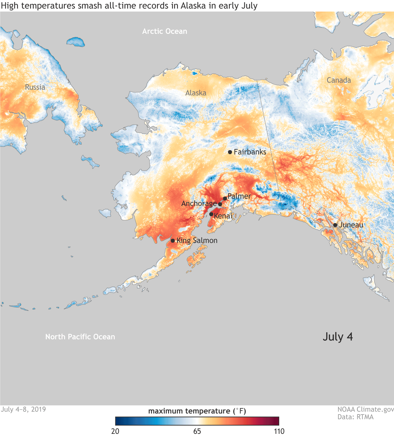 [This animated gif shows the build-up of extremely high daytime high temperatures across Alaska from July 4–8, 2019. Temperatures cooler than 65°F are shades of blue; those warmer than 65°F are yellow, orange, and red. NOAA Climate image, based on RTMA data.]
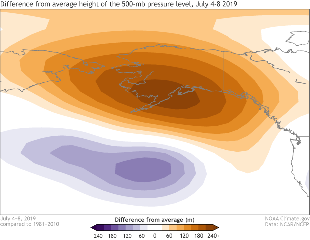 [A dome of high pressure squatted over Alaska July 4–8, 2019, keeping temperatures high and skies cloud-free. The 500-millibar pressure level—the altitude at which the air has thinned enough to drop the pressure to 500 millibars—was more than a hundred meters taller than average during the period. NOAA Climate image, based on NCAR/NCEP Reanalysis data provided by ESRL Physical Sciences Division.]
In a historical context, Alaska has a tendency for warmer than average conditions during the summer when El Niño conditions are present in the equatorial Pacific. However, this year’s El Niño has been weak, making any connection to the current Alaskan heatwave an open question.
[A dome of high pressure squatted over Alaska July 4–8, 2019, keeping temperatures high and skies cloud-free. The 500-millibar pressure level—the altitude at which the air has thinned enough to drop the pressure to 500 millibars—was more than a hundred meters taller than average during the period. NOAA Climate image, based on NCAR/NCEP Reanalysis data provided by ESRL Physical Sciences Division.]
In a historical context, Alaska has a tendency for warmer than average conditions during the summer when El Niño conditions are present in the equatorial Pacific. However, this year’s El Niño has been weak, making any connection to the current Alaskan heatwave an open question.
[This animated gif shows the build-up of extremely high daytime high temperatures across Alaska from July 4–8, 2019. Temperatures cooler than 65°F are shades of blue; those warmer than 65°F are yellow, orange, and red. NOAA Climate image, based on RTMA data.]
How hot? ALASKA hot.
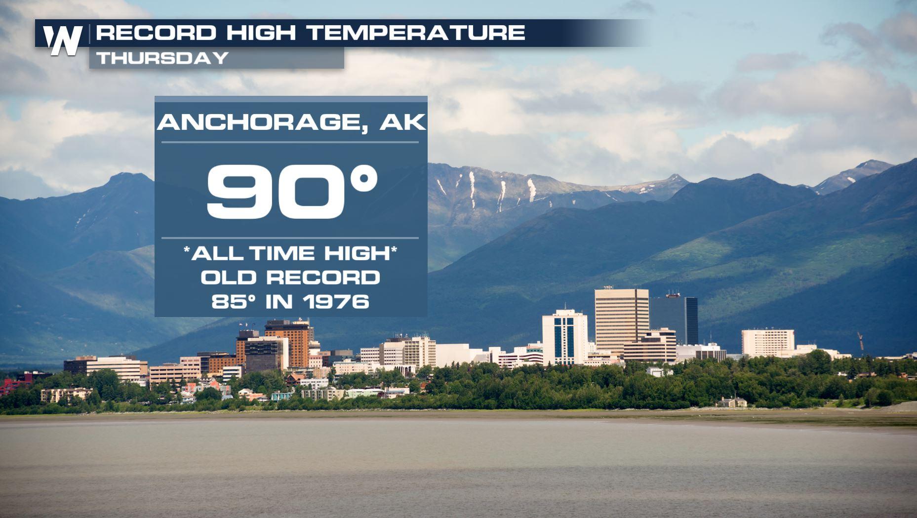
Starting on the Fourth of July and lasting multiple days, temperatures across Alaska were 20 to 30 degrees above average in some locations. On July 4, all-time high temperature records were set in Kenai, Palmer, King Salmon, and Anchorage International Airport. The airport reached an astounding, for Alaska, 90°F, breaking the previous all-time record by 5°F! The average temperature in Anchorage during summer is normally in the mid-sixties. Anchorage, Talkeetna (which saw a July record daily high of 93°F), and King Salmon also observed their warmest week on record. And the anomalous Arctic heat has not been short-lived. Through July 10, Juneau saw the high temperature reach at least 70°F for a record 17 consecutive days. In Anchorage, the highs have reached 80°F for a record six consecutive days, doubling the previous record. And three of those days broke or tied the previous all-time record! The average high temperature from June 27 through July 8 was nearly 81°F, 5.5°F higher than the previous 12-day record. There’s out of the ordinary, and then there is what has been happening in Alaska. https://youtu.be/hzL4RoPnXSUWhat was going on in the atmosphere?
A large dome of high pressure sat over the region for more than a week, keeping clouds away and allowing for much warmer than average temperatures to persist. Over Anchorage, the average height of the 500mb pressure level in the atmosphere set a July record, and tied the July record in Fairbanks, according to Rick Thoman of Alaska Center for Climate Assessment and Policy. (Atmospheric pressure generally declines with altitude. A pressure level is the height above the surface at which the air pressure has fallen off to a given threshold, for example, 500 mb.)
[A dome of high pressure squatted over Alaska July 4–8, 2019, keeping temperatures high and skies cloud-free. The 500-millibar pressure level—the altitude at which the air has thinned enough to drop the pressure to 500 millibars—was more than a hundred meters taller than average during the period. NOAA Climate image, based on NCAR/NCEP Reanalysis data provided by ESRL Physical Sciences Division.]
In a historical context, Alaska has a tendency for warmer than average conditions during the summer when El Niño conditions are present in the equatorial Pacific. However, this year’s El Niño has been weak, making any connection to the current Alaskan heatwave an open question.
You said this was one of several extreme events going on in Alaska? What are the others?
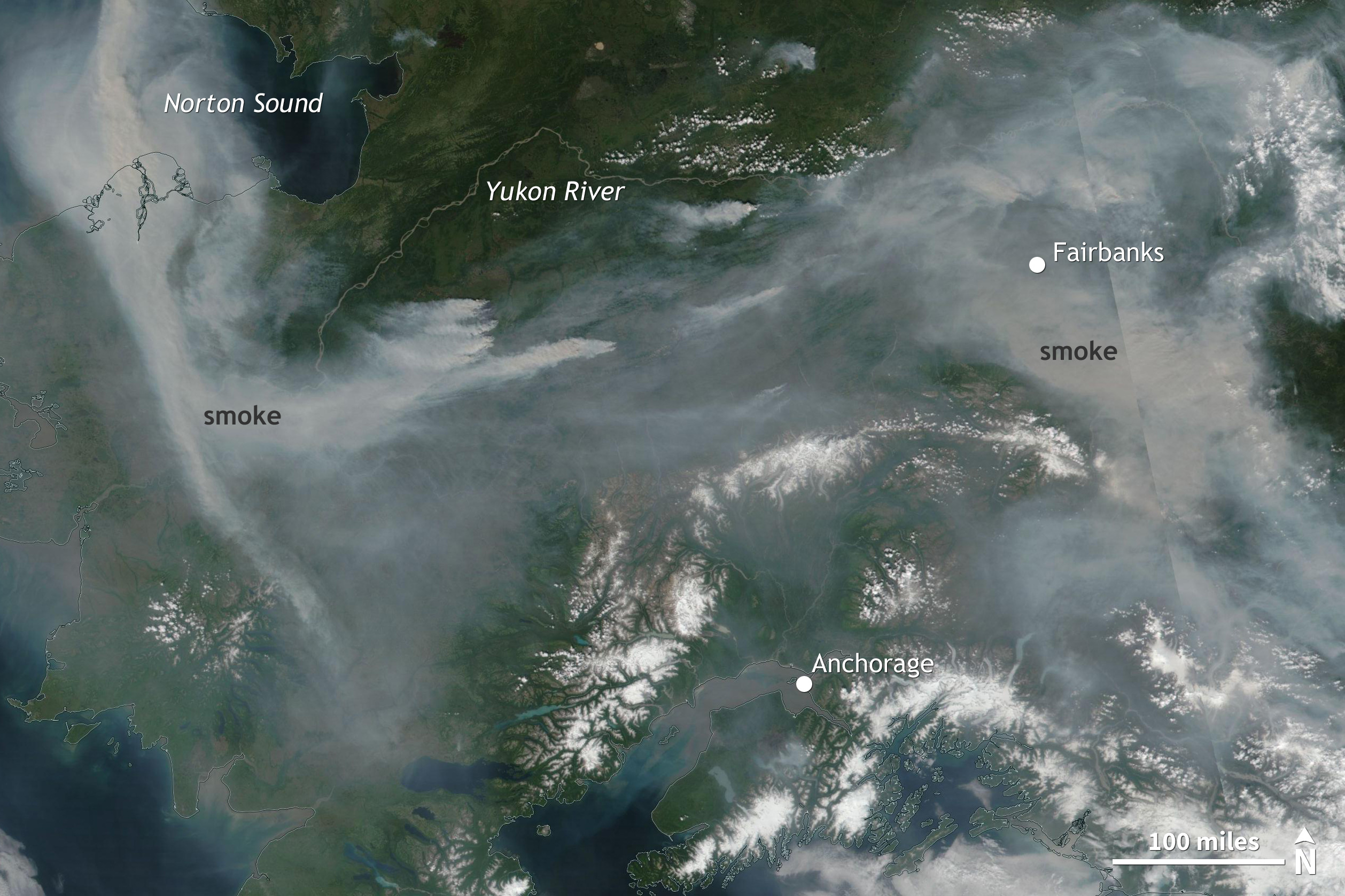
Where to begin? June was the second warmest on record for Alaska. The hot temperatures were accompanied by dry conditions, creating the perfect set-up for wildfires. Alaskan wildfires have burned well 1.6 million acres in 2019 through July 14, according to the Alaska Interagency Coordinate Center. Nearly 1,000,000 acres have burned just since July 3.[Numerous large fires billowed smoke across Alaska on July 8, 2019. Both Fairbanks, in central Alaska, and Anchorage, on the southern coast, were under the pall, creating unhealthy air quality. NOAA Climate image, based on NOAA/NASA satellite data provided by Worldview.]
The smoke from those wildfires has drifted towards the major population centers and choked the air across southern western and interior Alaska, leading to the first ever dense smoke advisory for Anchorage and some of the worst air quality in the world in Anchorage and Fairbanks. The smoke has made it difficult for the many people to cool off: air conditioning is rare, and opening the windows is a nonstarter.
Meanwhile, the well above average air temperatures have also coincided with, and were likely influenced by, well above average ocean temperatures around the state as well as record-low sea ice in the Bering and Chukchi seas. Overall, the total amount of sea ice in the Arctic is currently running neck and neck with 2012, the year which ended up with the lowest ice extent in the satellite record.
Edited for WeatherNation by Meteorologist Mace Michaels
All Weather News
More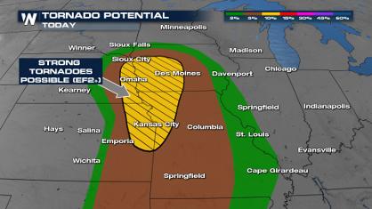
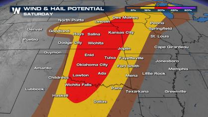
Weekend Forecast: More Severe Weather
With another severe weather outbreak underway
26 Apr 2024 2:20 PM
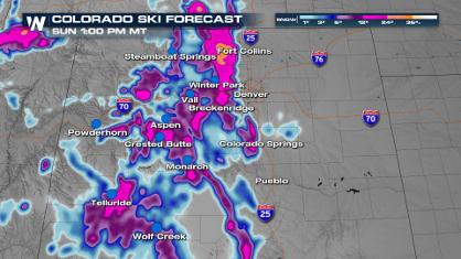
Spring Snow on the Horizon in Colorado
Snow is on the way for the mountains of Color
26 Apr 2024 2:15 PM
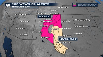
Critical Fire Risk in West Texas, New Mexico
A critical fire risk is in place for west Tex
26 Apr 2024 2:15 PM

National Park Week: Get Out and Explore
National Park Week started Saturday, April 20
26 Apr 2024 11:55 AM

NOAA Debuts "HeatRisk" Tool Nationwide
More people die from heat every year than ALL
25 Apr 2024 9:00 PM

Double Trouble: Cicadas Take to the Skies this Spring
It’s the soundtrack to the summer. Nature’s n
25 Apr 2024 8:45 PM