Final Chapter On 40 Year Historic Polar-Orbiting Satellite Program
Special Stories
18 Dec 2018 6:45 AM
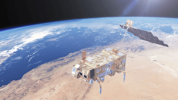
[Metop satellite from ESA]
[NOAA] The Polar-orbiting Operational Environmental Satellite (POES) project can claim a number of firsts in its 40-year history. It was the nation’s first to provide global search and rescue capabilities from space. Its NOAA-10 and NOAA-11 satellites captured the first cloudless photograph of the entire planet Earth, pieced together using thousands of images. And its advanced data collection system, which pulled environmental data from buoys, balloons, tagged sea animals and streams, inspired a major citizen science effort on the ground and in classrooms around the country.
As the Metop-C satellite lifted off from the launchpad on November 7, the last of the legacy POES mission instruments were sent into space, closing a final chapter on the historic program. The NASA Goddard Space Flight Center (GSFC) is responsible for the construction, integration and launch of NOAA-series satellites.
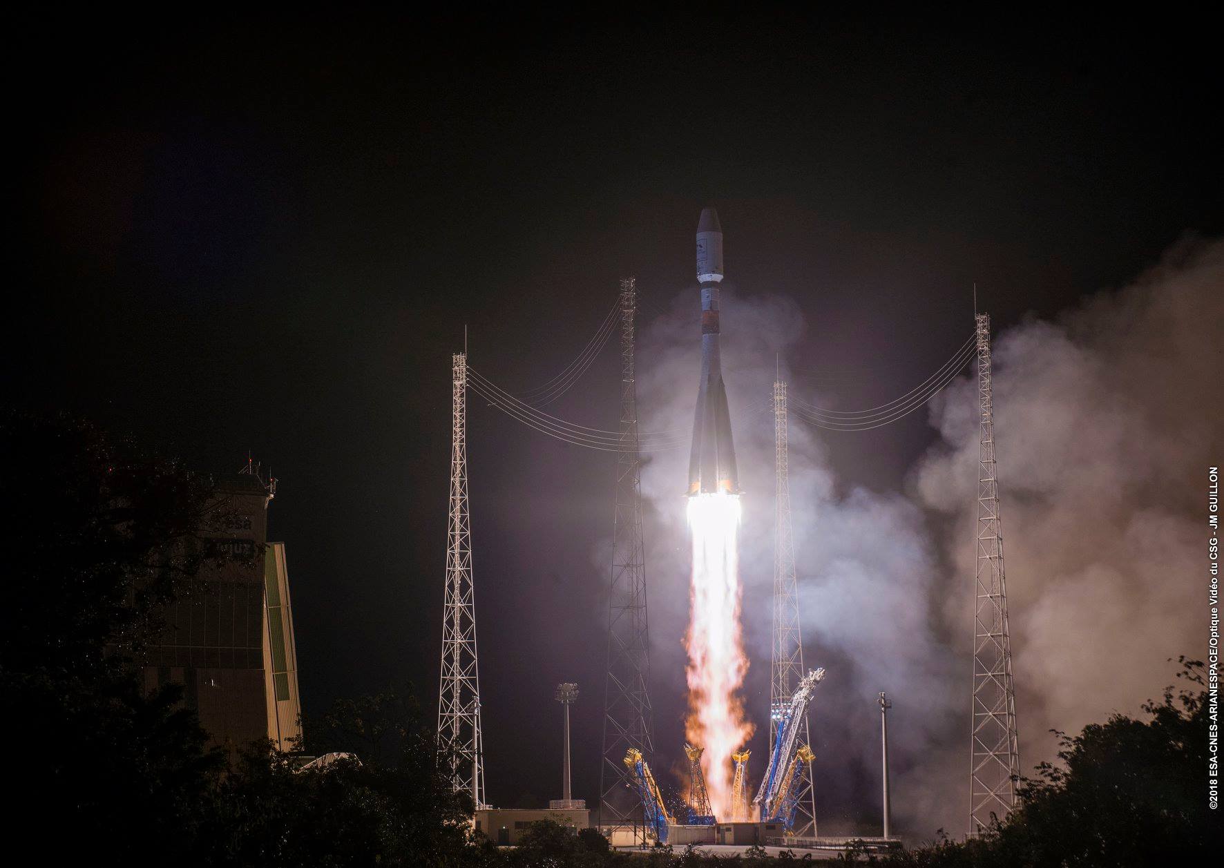 [Metop-C launched on a Soyuz rocket from Europe’s Spaceport in French Guiana on Nov. 7, carrying four POES-legacy instruments. (Image by ESA-CNES-Arianespace/Optique du CSG - JM. Guillon)]
Metop-C is the successor to Metop-B and Metop-A, and it carries four POES-legacy instruments: The Advanced Very High-Resolution Radiometer (AVHRR), the Advanced Microwave Sounding Units, AMSU-A1 and AMSU-A2, and the Space Environment Monitor, SEM-2. AVHRR captures visible and infrared imagery of clouds, oceans, the atmosphere, ice, and land surfaces. AMSU-A1 and AMSU-A2 measure global atmospheric temperature, humidity, precipitation and snow and ice cover in all weather conditions. And the Space Environment Monitor studies energetic particles in the upper atmosphere.
Weather satellites date back to 1960, when TIROS-1 first launched from Cape Canaveral. The early satellite carried two TV cameras and two video recorders, and for the first time, gave forecasters a fuzzy picture of cloud formations moving across the planet.
“Finally, you could see what a hurricane looked like, or a line of thunderstorms,” said Mitch Goldberg, NOAA program scientist for the Joint Polar Satellite System.
[Metop-C launched on a Soyuz rocket from Europe’s Spaceport in French Guiana on Nov. 7, carrying four POES-legacy instruments. (Image by ESA-CNES-Arianespace/Optique du CSG - JM. Guillon)]
Metop-C is the successor to Metop-B and Metop-A, and it carries four POES-legacy instruments: The Advanced Very High-Resolution Radiometer (AVHRR), the Advanced Microwave Sounding Units, AMSU-A1 and AMSU-A2, and the Space Environment Monitor, SEM-2. AVHRR captures visible and infrared imagery of clouds, oceans, the atmosphere, ice, and land surfaces. AMSU-A1 and AMSU-A2 measure global atmospheric temperature, humidity, precipitation and snow and ice cover in all weather conditions. And the Space Environment Monitor studies energetic particles in the upper atmosphere.
Weather satellites date back to 1960, when TIROS-1 first launched from Cape Canaveral. The early satellite carried two TV cameras and two video recorders, and for the first time, gave forecasters a fuzzy picture of cloud formations moving across the planet.
“Finally, you could see what a hurricane looked like, or a line of thunderstorms,” said Mitch Goldberg, NOAA program scientist for the Joint Polar Satellite System.
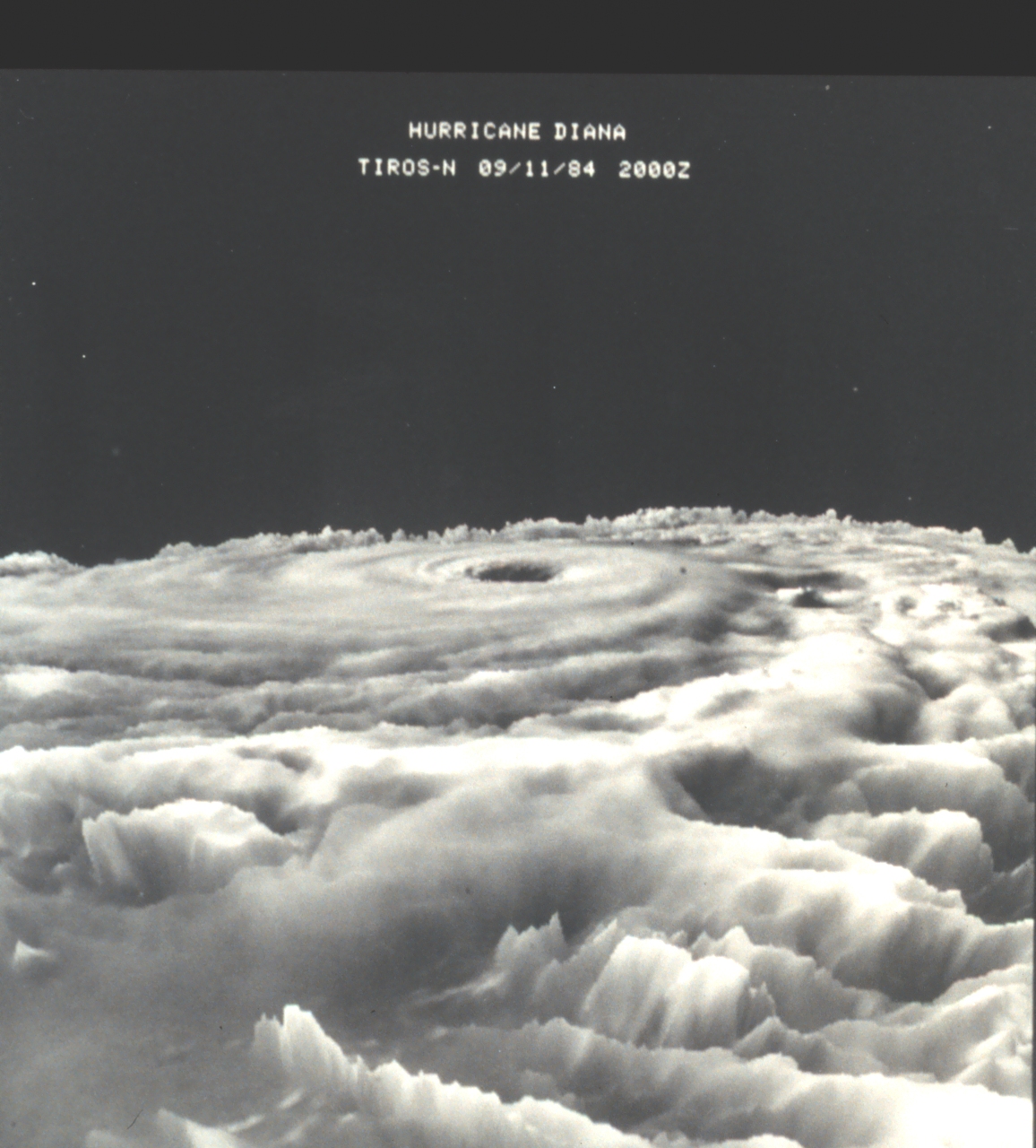 [This cloud-top image of Hurricane Diana captured by TIROS N on Sept. 11, 1984, was one of the earliest three-dimensional images of a hurricane from data obtained from a satellite. It shows the hurricane as it was strengthening from a Category-3 to a Category-4 storm. (Image courtesy NOAA In Space Collection)]
The POES program began 18 years later with the launch of TIROS-N. In the years since, it has launched 16 satellites, provided decades of critical climate and weather data and contributed to saving more than 28,000 lives with its search and rescue instruments.
Beginning with TIROS-N, the satellites had microwave sounding instruments that could see through the clouds.
“Microwave data allowed knowledge of whether it is snowing or raining and what rain rates and humidity levels were,” said Tom Wrublewski, a NOAA scientist with the Joint Polar Satellite System flight project. “It even allowed us to know whether snow and ice melted during the day and refroze at night.”
The global sea surface temperature data provided by the AVHRR instruments on the POES satellites also played a key role in tracking El Niño, the climate pattern that causes warm water to slosh across the Pacific Ocean, influencing all kinds of weird weather and fishing anomalies.
In 1971, Joe Witte was working as a meteorologist for Seattle’s King TV station. At the time, satellite images would arrive by fax, and Witte would snap a polaroid of the grainy picture, tape it onto the studio wall, and during forecasts, point to it with a pencil, as the cameras zoomed in on a tight shot. He reflects on how much the quality and distribution of the satellite images have evolved since then.
[This cloud-top image of Hurricane Diana captured by TIROS N on Sept. 11, 1984, was one of the earliest three-dimensional images of a hurricane from data obtained from a satellite. It shows the hurricane as it was strengthening from a Category-3 to a Category-4 storm. (Image courtesy NOAA In Space Collection)]
The POES program began 18 years later with the launch of TIROS-N. In the years since, it has launched 16 satellites, provided decades of critical climate and weather data and contributed to saving more than 28,000 lives with its search and rescue instruments.
Beginning with TIROS-N, the satellites had microwave sounding instruments that could see through the clouds.
“Microwave data allowed knowledge of whether it is snowing or raining and what rain rates and humidity levels were,” said Tom Wrublewski, a NOAA scientist with the Joint Polar Satellite System flight project. “It even allowed us to know whether snow and ice melted during the day and refroze at night.”
The global sea surface temperature data provided by the AVHRR instruments on the POES satellites also played a key role in tracking El Niño, the climate pattern that causes warm water to slosh across the Pacific Ocean, influencing all kinds of weird weather and fishing anomalies.
In 1971, Joe Witte was working as a meteorologist for Seattle’s King TV station. At the time, satellite images would arrive by fax, and Witte would snap a polaroid of the grainy picture, tape it onto the studio wall, and during forecasts, point to it with a pencil, as the cameras zoomed in on a tight shot. He reflects on how much the quality and distribution of the satellite images have evolved since then.
 [This cloud-top image of Hurricane Diana captured by TIROS N on Sept. 11, 1984, was one of the earliest three-dimensional images of a hurricane from data obtained from a satellite. It shows the hurricane as it was strengthening from a Category-3 to a Category-4 storm. (Image courtesy NOAA In Space Collection)]
“That was just really hi-tech at the time,” Witte said, “Black and white photograph, pencil and all. It’s amazing now that people can have the images on their phone almost in real time.”
“You have a whole class of spacecraft and instruments that are used for decades,” Gleason said, referencing POES, “and then you make the shift to much more advanced instruments and different spacecraft. AVHRR had six channels. VIIRS has 22. The microwave instruments were in three boxes on the satellite; now they’re in one.”
But today’s weather satellites have been shaped by the decades of rich history and lessons learned from their polar-orbiting ancestors.
The POES program, Wrublewski said, “saved countless lives over the decades, in terms of search and rescue, input to the weather service modeling and how you plan your day. There are some countries that don’t have their own weather service, but they could get our imagery for free.”
Metop-C is part of a collaboration between EUMETSAT, the European Organization for the Exploitation of Meteorological Satellites, and NOAA, with contributions from NASA and the European Space Agency.
Edited for WeatherNation by Meteorologist Mace Michaels
[This cloud-top image of Hurricane Diana captured by TIROS N on Sept. 11, 1984, was one of the earliest three-dimensional images of a hurricane from data obtained from a satellite. It shows the hurricane as it was strengthening from a Category-3 to a Category-4 storm. (Image courtesy NOAA In Space Collection)]
“That was just really hi-tech at the time,” Witte said, “Black and white photograph, pencil and all. It’s amazing now that people can have the images on their phone almost in real time.”
“You have a whole class of spacecraft and instruments that are used for decades,” Gleason said, referencing POES, “and then you make the shift to much more advanced instruments and different spacecraft. AVHRR had six channels. VIIRS has 22. The microwave instruments were in three boxes on the satellite; now they’re in one.”
But today’s weather satellites have been shaped by the decades of rich history and lessons learned from their polar-orbiting ancestors.
The POES program, Wrublewski said, “saved countless lives over the decades, in terms of search and rescue, input to the weather service modeling and how you plan your day. There are some countries that don’t have their own weather service, but they could get our imagery for free.”
Metop-C is part of a collaboration between EUMETSAT, the European Organization for the Exploitation of Meteorological Satellites, and NOAA, with contributions from NASA and the European Space Agency.
Edited for WeatherNation by Meteorologist Mace Michaels
[Metop-C launched on a Soyuz rocket from Europe’s Spaceport in French Guiana on Nov. 7, carrying four POES-legacy instruments. (Image by ESA-CNES-Arianespace/Optique du CSG - JM. Guillon)]
Metop-C is the successor to Metop-B and Metop-A, and it carries four POES-legacy instruments: The Advanced Very High-Resolution Radiometer (AVHRR), the Advanced Microwave Sounding Units, AMSU-A1 and AMSU-A2, and the Space Environment Monitor, SEM-2. AVHRR captures visible and infrared imagery of clouds, oceans, the atmosphere, ice, and land surfaces. AMSU-A1 and AMSU-A2 measure global atmospheric temperature, humidity, precipitation and snow and ice cover in all weather conditions. And the Space Environment Monitor studies energetic particles in the upper atmosphere.
Weather satellites date back to 1960, when TIROS-1 first launched from Cape Canaveral. The early satellite carried two TV cameras and two video recorders, and for the first time, gave forecasters a fuzzy picture of cloud formations moving across the planet.
“Finally, you could see what a hurricane looked like, or a line of thunderstorms,” said Mitch Goldberg, NOAA program scientist for the Joint Polar Satellite System.
[This cloud-top image of Hurricane Diana captured by TIROS N on Sept. 11, 1984, was one of the earliest three-dimensional images of a hurricane from data obtained from a satellite. It shows the hurricane as it was strengthening from a Category-3 to a Category-4 storm. (Image courtesy NOAA In Space Collection)]
The POES program began 18 years later with the launch of TIROS-N. In the years since, it has launched 16 satellites, provided decades of critical climate and weather data and contributed to saving more than 28,000 lives with its search and rescue instruments.
Beginning with TIROS-N, the satellites had microwave sounding instruments that could see through the clouds.
“Microwave data allowed knowledge of whether it is snowing or raining and what rain rates and humidity levels were,” said Tom Wrublewski, a NOAA scientist with the Joint Polar Satellite System flight project. “It even allowed us to know whether snow and ice melted during the day and refroze at night.”
The global sea surface temperature data provided by the AVHRR instruments on the POES satellites also played a key role in tracking El Niño, the climate pattern that causes warm water to slosh across the Pacific Ocean, influencing all kinds of weird weather and fishing anomalies.
In 1971, Joe Witte was working as a meteorologist for Seattle’s King TV station. At the time, satellite images would arrive by fax, and Witte would snap a polaroid of the grainy picture, tape it onto the studio wall, and during forecasts, point to it with a pencil, as the cameras zoomed in on a tight shot. He reflects on how much the quality and distribution of the satellite images have evolved since then.
[This cloud-top image of Hurricane Diana captured by TIROS N on Sept. 11, 1984, was one of the earliest three-dimensional images of a hurricane from data obtained from a satellite. It shows the hurricane as it was strengthening from a Category-3 to a Category-4 storm. (Image courtesy NOAA In Space Collection)]
“That was just really hi-tech at the time,” Witte said, “Black and white photograph, pencil and all. It’s amazing now that people can have the images on their phone almost in real time.”
“You have a whole class of spacecraft and instruments that are used for decades,” Gleason said, referencing POES, “and then you make the shift to much more advanced instruments and different spacecraft. AVHRR had six channels. VIIRS has 22. The microwave instruments were in three boxes on the satellite; now they’re in one.”
But today’s weather satellites have been shaped by the decades of rich history and lessons learned from their polar-orbiting ancestors.
The POES program, Wrublewski said, “saved countless lives over the decades, in terms of search and rescue, input to the weather service modeling and how you plan your day. There are some countries that don’t have their own weather service, but they could get our imagery for free.”
Metop-C is part of a collaboration between EUMETSAT, the European Organization for the Exploitation of Meteorological Satellites, and NOAA, with contributions from NASA and the European Space Agency.
Edited for WeatherNation by Meteorologist Mace MichaelsAll Weather News
More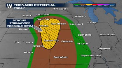
Spring Snow on the Horizon in Colorado
Snow is on the way for the mountains of Color
26 Apr 2024 12:10 PM
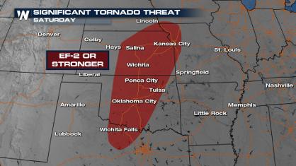
Weekend Forecast: More Severe Weather
With another severe weather outbreak underway
26 Apr 2024 12:05 PM
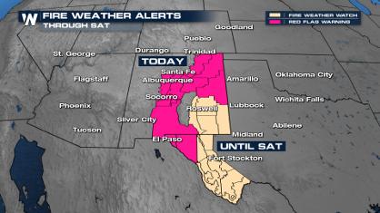
Critical Fire Risk in West Texas, New Mexico
A critical fire risk is in place for west Tex
26 Apr 2024 12:00 PM

National Park Week: Get Out and Explore
National Park Week started Saturday, April 20
26 Apr 2024 11:55 AM

NOAA Debuts "HeatRisk" Tool Nationwide
More people die from heat every year than ALL
25 Apr 2024 9:00 PM

Double Trouble: Cicadas Take to the Skies this Spring
It’s the soundtrack to the summer. Nature’s n
25 Apr 2024 8:45 PM