New Research Offers Potential to Predict Atmospheric River Activity up to 5 Weeks Ahead
Special Stories
23 Feb 2018 12:34 PM
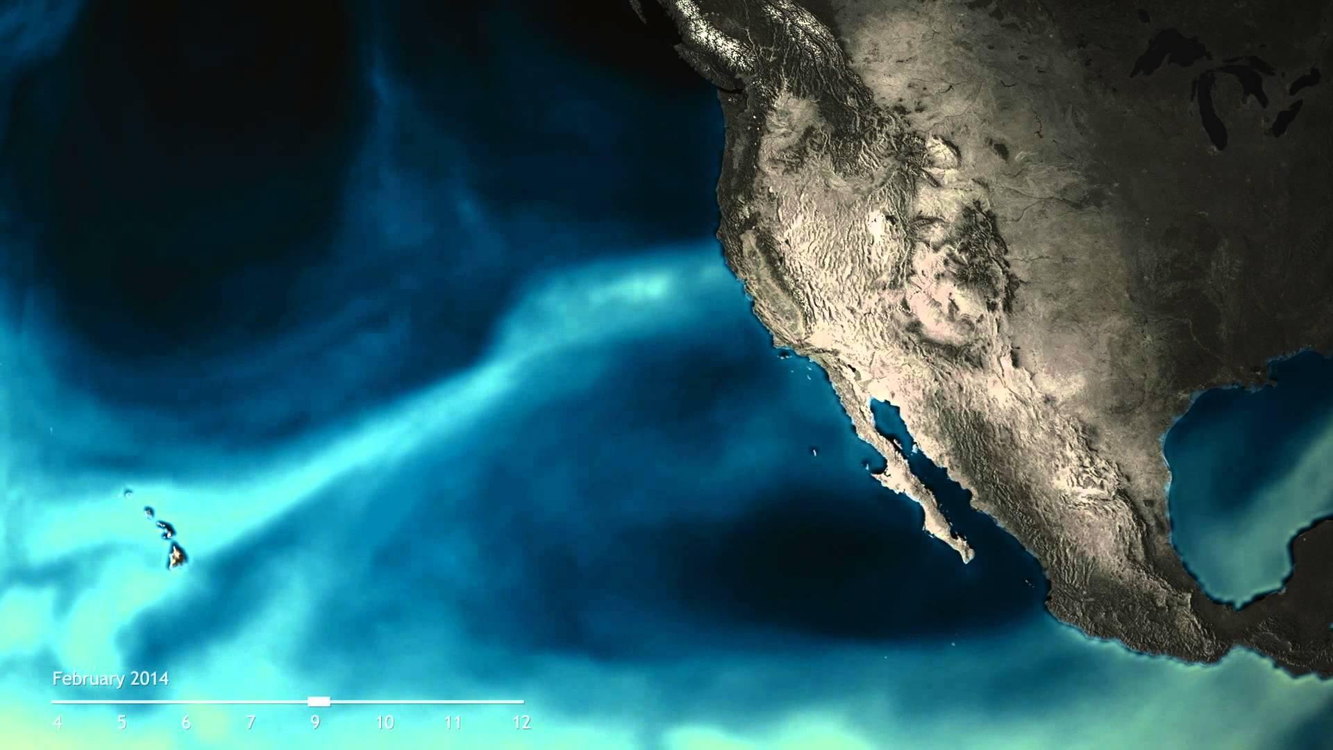
[Atmospheric river off California, February 2014. Credit: Still from an animation by NOAA Climate.].
From NOAA
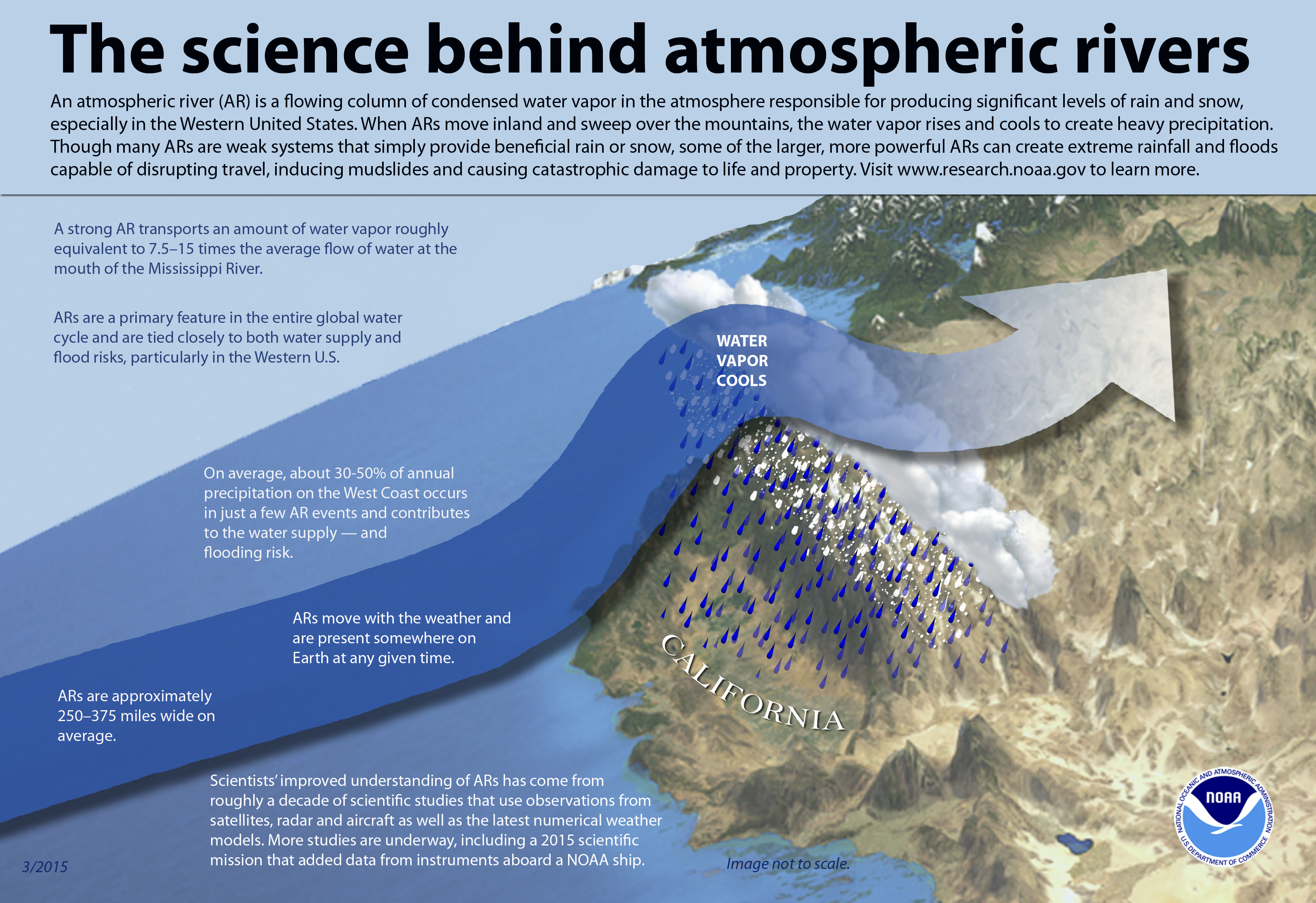
Those long, intense plumes of moisture in the sky known as atmospheric rivers are a vital water source to communities along the U.S. West Coast. In their absence, desiccating droughts can develop. But in their presence, they can cause extreme rain and floods that can disrupt travel, cause landslides, and trigger infrastructure failures.
 Currently, no guidance exists to help decision-makers plan for these events more than two weeks in advance, but a new study in the Nature Partner Journal Climate and Atmospheric Science describes a breakthrough in accurately predicting atmospheric river behavior several weeks ahead.
A team of Colorado State University (CSU) atmospheric scientists, funded by NOAA Research’s MAPP Program, developed and tested a model fed by careful analysis of 37 years of historical weather data. Their model centers on the relationship between two well-known global atmospheric patterns: the Madden-Julian Oscillation (MJO)—a recurring tropical rainfall pattern—and the Quasi-Biennial Oscillation (QBO)—an alternating pattern of winds high up in the stratosphere, above the MJO.
Currently, no guidance exists to help decision-makers plan for these events more than two weeks in advance, but a new study in the Nature Partner Journal Climate and Atmospheric Science describes a breakthrough in accurately predicting atmospheric river behavior several weeks ahead.
A team of Colorado State University (CSU) atmospheric scientists, funded by NOAA Research’s MAPP Program, developed and tested a model fed by careful analysis of 37 years of historical weather data. Their model centers on the relationship between two well-known global atmospheric patterns: the Madden-Julian Oscillation (MJO)—a recurring tropical rainfall pattern—and the Quasi-Biennial Oscillation (QBO)—an alternating pattern of winds high up in the stratosphere, above the MJO.
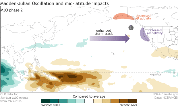 [As the cluster of storms and rainfall (green areas) known as the MJO travel around the tropics, they kick off planetary-scale waves in the mid-latitude atmosphere. Depending on the phase (location) of the MJO, the waves can alternately block or steer the flow of atmospheric rivers around various high and low pressure systems and toward either the Gulf of Alaska or the U.S. West Coast. Credit: NOAA Climate animation, by Cordelia Norris.]
These phenomena occur thousands of miles from the U.S. along the Earth's equator. But the research team, led by former graduate researcher Bryan Mundhenk, knows that far-flung, interconnected processes between the ocean and atmosphere are crucial to making better, longer-term predictions than are currently possible.
According to the study, co-authored by CSU professors Libby Barnes and Eric Maloney, the current state of the MJO and QBO can help skillfully predict when and where atmospheric river activity will impact the West Coast up to five weeks in advance.
[As the cluster of storms and rainfall (green areas) known as the MJO travel around the tropics, they kick off planetary-scale waves in the mid-latitude atmosphere. Depending on the phase (location) of the MJO, the waves can alternately block or steer the flow of atmospheric rivers around various high and low pressure systems and toward either the Gulf of Alaska or the U.S. West Coast. Credit: NOAA Climate animation, by Cordelia Norris.]
These phenomena occur thousands of miles from the U.S. along the Earth's equator. But the research team, led by former graduate researcher Bryan Mundhenk, knows that far-flung, interconnected processes between the ocean and atmosphere are crucial to making better, longer-term predictions than are currently possible.
According to the study, co-authored by CSU professors Libby Barnes and Eric Maloney, the current state of the MJO and QBO can help skillfully predict when and where atmospheric river activity will impact the West Coast up to five weeks in advance.
 "It's impressive, considering that current state-of-the-art numerical weather models, such as NOAA's Global Forecast System, or the European Centre for Medium-Range Weather Forecasts' operational model, are only skillful up to 1-2 weeks in advance," says paper co-author Cory Baggett, a postdoctoral researcher in the Barnes and Maloney labs.
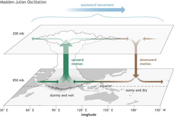
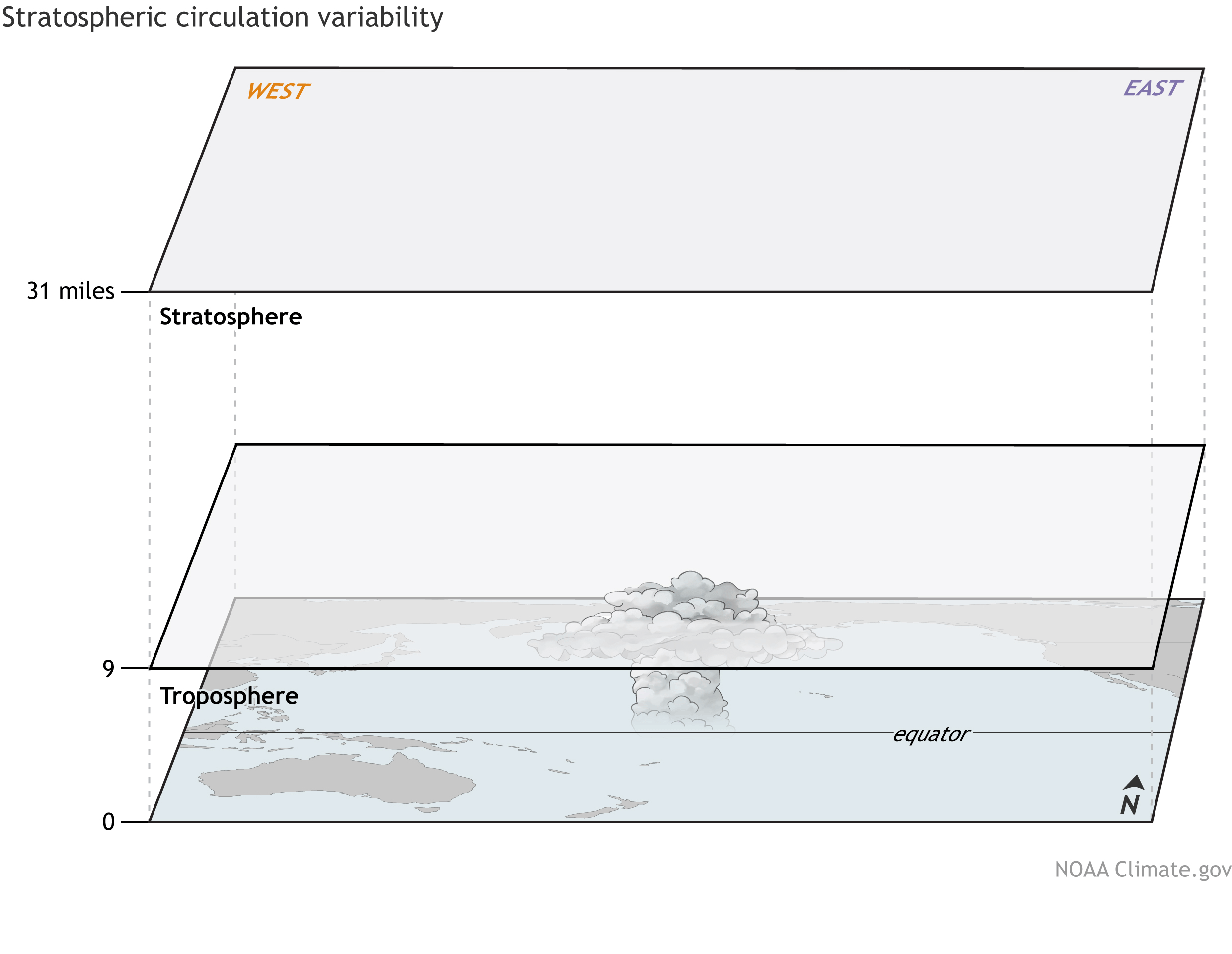 [The wind in the tropical stratosphere shifts between easterlies and westerlies over two to three years. This alternating pattern is called the QBO. Credit: NOAA Climate animation.]
“The empirical model uses observed, historical information concerning the relationship between the MJO, QBO, and atmospheric rivers to make its prediction,” said Baggett. Consequently, if more atmospheric river activity was historically observed three weeks after a particular MJO and QBO state, then the model would forecast above normal atmospheric river activity for similar sequences in the future.The same relationship stands for periods of decreased activity, which is important information for assessing water supply risks.
“Because atmospheric rivers have such wide ranging impacts, these findings could benefit numerous sectors of society,” said the authors. “Skillful predictions 3 to 5 weeks in advance provide local emergency officials and reservoir managers with valuable information that they can act on.”
Edited for WeatherNation by Meteorologist Mace Michaels
[The wind in the tropical stratosphere shifts between easterlies and westerlies over two to three years. This alternating pattern is called the QBO. Credit: NOAA Climate animation.]
“The empirical model uses observed, historical information concerning the relationship between the MJO, QBO, and atmospheric rivers to make its prediction,” said Baggett. Consequently, if more atmospheric river activity was historically observed three weeks after a particular MJO and QBO state, then the model would forecast above normal atmospheric river activity for similar sequences in the future.The same relationship stands for periods of decreased activity, which is important information for assessing water supply risks.
“Because atmospheric rivers have such wide ranging impacts, these findings could benefit numerous sectors of society,” said the authors. “Skillful predictions 3 to 5 weeks in advance provide local emergency officials and reservoir managers with valuable information that they can act on.”
Edited for WeatherNation by Meteorologist Mace Michaels
Currently, no guidance exists to help decision-makers plan for these events more than two weeks in advance, but a new study in the Nature Partner Journal Climate and Atmospheric Science describes a breakthrough in accurately predicting atmospheric river behavior several weeks ahead.
A team of Colorado State University (CSU) atmospheric scientists, funded by NOAA Research’s MAPP Program, developed and tested a model fed by careful analysis of 37 years of historical weather data. Their model centers on the relationship between two well-known global atmospheric patterns: the Madden-Julian Oscillation (MJO)—a recurring tropical rainfall pattern—and the Quasi-Biennial Oscillation (QBO)—an alternating pattern of winds high up in the stratosphere, above the MJO.
[As the cluster of storms and rainfall (green areas) known as the MJO travel around the tropics, they kick off planetary-scale waves in the mid-latitude atmosphere. Depending on the phase (location) of the MJO, the waves can alternately block or steer the flow of atmospheric rivers around various high and low pressure systems and toward either the Gulf of Alaska or the U.S. West Coast. Credit: NOAA Climate animation, by Cordelia Norris.]
These phenomena occur thousands of miles from the U.S. along the Earth's equator. But the research team, led by former graduate researcher Bryan Mundhenk, knows that far-flung, interconnected processes between the ocean and atmosphere are crucial to making better, longer-term predictions than are currently possible.
According to the study, co-authored by CSU professors Libby Barnes and Eric Maloney, the current state of the MJO and QBO can help skillfully predict when and where atmospheric river activity will impact the West Coast up to five weeks in advance.
"It's impressive, considering that current state-of-the-art numerical weather models, such as NOAA's Global Forecast System, or the European Centre for Medium-Range Weather Forecasts' operational model, are only skillful up to 1-2 weeks in advance," says paper co-author Cory Baggett, a postdoctoral researcher in the Barnes and Maloney labs.
The QBO’s added influence
In their previous work, CSU researchers have uncovered key stages that influence atmospheric river activity — only by using the location of the eastward-propagating MJO. But with increasing evidence that the QBO’s shifting wind patterns over two to three years can directly impact the MJO, the authors wanted to know how much the QBO would affect their model’s predictions of atmospheric rivers. “The QBO matters,” said Baggett. “When we added the current state of the QBO to our model, it showed increased skill compared to using just the MJO alone.” Using the state of the MJO and the added influence of the QBO, the research team created the first empirical prediction model that can skillfully forecast periods of increased or decreased atmospheric river activity in the western U.S. up to 5 weeks ahead.
[The wind in the tropical stratosphere shifts between easterlies and westerlies over two to three years. This alternating pattern is called the QBO. Credit: NOAA Climate animation.]
“The empirical model uses observed, historical information concerning the relationship between the MJO, QBO, and atmospheric rivers to make its prediction,” said Baggett. Consequently, if more atmospheric river activity was historically observed three weeks after a particular MJO and QBO state, then the model would forecast above normal atmospheric river activity for similar sequences in the future.The same relationship stands for periods of decreased activity, which is important information for assessing water supply risks.
“Because atmospheric rivers have such wide ranging impacts, these findings could benefit numerous sectors of society,” said the authors. “Skillful predictions 3 to 5 weeks in advance provide local emergency officials and reservoir managers with valuable information that they can act on.”
Edited for WeatherNation by Meteorologist Mace MichaelsAll Weather News
More
Fronts Continue To Spark Severe Weather Across the Plains
A cold front that brought record lows to the
18 Jul 2025 10:40 PM

Extreme Heat Impacts for the East Coast & South
Extreme heat continues to impact several area
18 Jul 2025 10:05 PM

Flooding Threat Remains Elevated in the East
A cold front pushing through the Eastern Seab
18 Jul 2025 9:10 PM

EF-2 Firenado from the Deer Creek Fire in Utah
A fire tornado was spotted near La Sal, Utah
18 Jul 2025 7:30 AM

Tropical System Brings Flood Risk to the Central Gulf
Time has run out for notable tropical develop
18 Jul 2025 3:05 AM

Heavy Rain, Flooding Threat Returns to Florida
Keep the rain boots handy in Florida - heavy
13 Jul 2025 12:50 PM

Severe Storm Risk Pushes into the Great Lakes, Ohio Valley
Friday was another busy day with severe weath
12 Jul 2025 8:00 PM