NOAA Shares First New View of the North Pole from NOAA-20
Special Stories
20 Apr 2018 9:38 AM
From NOAA
With stunning clarity and unsurpassed detail, the newest polar orbiting satellite in the NOAA fleet, NOAA-20, took this image of the North Pole. The satellite passed over this area of the Earth at least 14 times to capture it.
 [NOAA-20 satellite shares first polar view, captured April 12]
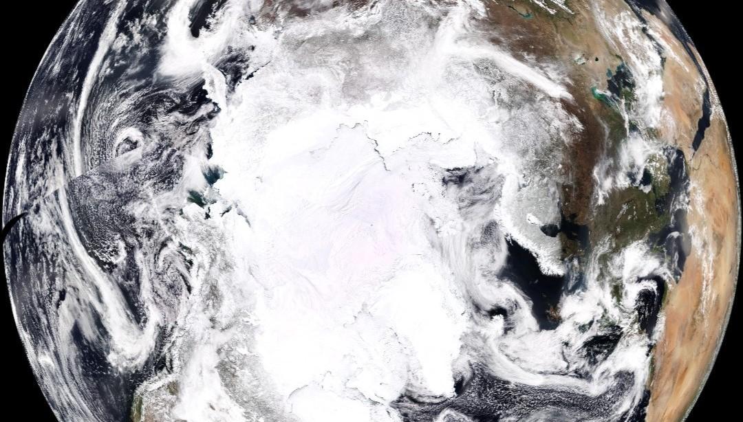
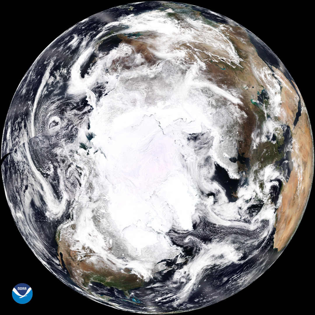
The VIIRS instrument onboard the satellite created this synthesized view of Earth with the North Pole directly in the center of the image. If you look closely, you’ll see the outline of the North American continent and the Baja Peninsula on the left hand side. Scientists use the data from the VIIRS sensor to create the ‘true-color’ product you see here. Like a photograph, the satellite reads the appearance of clouds, land, vegetation and water to create these images. This is the image we have of our planet as it would appear if we could take a single photograph of the entire Northern Hemisphere. The swath line shown on the left hand side represents the start and end of the 24-hour period taken by the satellite to create the image. The NOAA-20 satellite is able to capture this view each day, and the critical information contained within the data – combined with microwave and infrared information – enables more accurate weather forecasting for the United States and the world.
As the backbone of the global observing system, NOAA-20 circles the Earth from pole to pole and crosses the equator about 14 times daily, providing full global coverage twice a day. NOAA-20 is a critical asset with unique capabilities. Its Earth-observing instruments can measure temperature, water vapor, ozone, rainfall, detect fire and volcanic eruptions and can even distinguish snow and ice under clouds. These instruments enable us to observe and monitor the Earth.
[NOAA-20 satellite shares first polar view, captured April 12]
The VIIRS instrument onboard the satellite created this synthesized view of Earth with the North Pole directly in the center of the image. If you look closely, you’ll see the outline of the North American continent and the Baja Peninsula on the left hand side. Scientists use the data from the VIIRS sensor to create the ‘true-color’ product you see here. Like a photograph, the satellite reads the appearance of clouds, land, vegetation and water to create these images. This is the image we have of our planet as it would appear if we could take a single photograph of the entire Northern Hemisphere. The swath line shown on the left hand side represents the start and end of the 24-hour period taken by the satellite to create the image. The NOAA-20 satellite is able to capture this view each day, and the critical information contained within the data – combined with microwave and infrared information – enables more accurate weather forecasting for the United States and the world.
As the backbone of the global observing system, NOAA-20 circles the Earth from pole to pole and crosses the equator about 14 times daily, providing full global coverage twice a day. NOAA-20 is a critical asset with unique capabilities. Its Earth-observing instruments can measure temperature, water vapor, ozone, rainfall, detect fire and volcanic eruptions and can even distinguish snow and ice under clouds. These instruments enable us to observe and monitor the Earth.
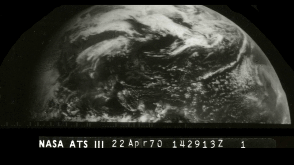 On April 22, 1970, Earth Day was established as an environmental teach-in with participants at universities and colleges across the U.S. Today, Earth Day is observed in 192 countries by more than one billion people. The imagery below was taken on the first Earth Day, April 22, 1970, by the Applications Technology Satellite-3 (ATS-3), a geostationary satellite that was positioned approximately 22,300 miles above Earth. This is the same orbit in which our GOES East and West satellites currently reside.
ATS-3’s spin-scan cloud camera provided continuous hemispheric images of the sun-lit Earth, seen here, every half hour. The success of the experimental ATS series led to the development of a satellite specifically designed to provide atmospheric observations from geostationary orbit. These satellites would become the Geostationary Operational Environmental Satellite (GOES) series, the first of which launched on October 16, 1975. GOES-4, launched in 1980, advanced meteorologists’ capabilities by providing continuous vertical temperature and water vapor profiles of Earth’s atmosphere.
Edited for WeatherNation by Meteorologist Mace Michaels
On April 22, 1970, Earth Day was established as an environmental teach-in with participants at universities and colleges across the U.S. Today, Earth Day is observed in 192 countries by more than one billion people. The imagery below was taken on the first Earth Day, April 22, 1970, by the Applications Technology Satellite-3 (ATS-3), a geostationary satellite that was positioned approximately 22,300 miles above Earth. This is the same orbit in which our GOES East and West satellites currently reside.
ATS-3’s spin-scan cloud camera provided continuous hemispheric images of the sun-lit Earth, seen here, every half hour. The success of the experimental ATS series led to the development of a satellite specifically designed to provide atmospheric observations from geostationary orbit. These satellites would become the Geostationary Operational Environmental Satellite (GOES) series, the first of which launched on October 16, 1975. GOES-4, launched in 1980, advanced meteorologists’ capabilities by providing continuous vertical temperature and water vapor profiles of Earth’s atmosphere.
Edited for WeatherNation by Meteorologist Mace Michaels
[NOAA-20 satellite shares first polar view, captured April 12]
The VIIRS instrument onboard the satellite created this synthesized view of Earth with the North Pole directly in the center of the image. If you look closely, you’ll see the outline of the North American continent and the Baja Peninsula on the left hand side. Scientists use the data from the VIIRS sensor to create the ‘true-color’ product you see here. Like a photograph, the satellite reads the appearance of clouds, land, vegetation and water to create these images. This is the image we have of our planet as it would appear if we could take a single photograph of the entire Northern Hemisphere. The swath line shown on the left hand side represents the start and end of the 24-hour period taken by the satellite to create the image. The NOAA-20 satellite is able to capture this view each day, and the critical information contained within the data – combined with microwave and infrared information – enables more accurate weather forecasting for the United States and the world.
As the backbone of the global observing system, NOAA-20 circles the Earth from pole to pole and crosses the equator about 14 times daily, providing full global coverage twice a day. NOAA-20 is a critical asset with unique capabilities. Its Earth-observing instruments can measure temperature, water vapor, ozone, rainfall, detect fire and volcanic eruptions and can even distinguish snow and ice under clouds. These instruments enable us to observe and monitor the Earth.
Satellite data can help us see our Earth like never before!
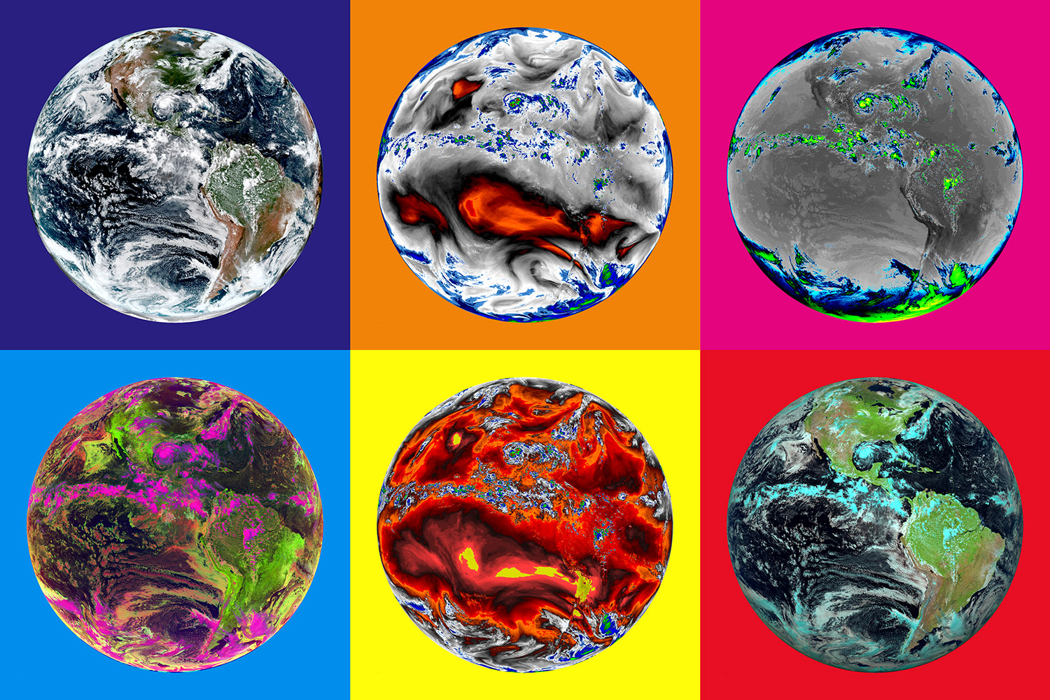
The vast amount of data continuously captured by NOAA’s fleet of satellites allows scientists to observe and analyze aspects of Earth’s atmosphere and climate to measure things like moisture in the air and temperature on the ground. This data can be ‘colorized’ so that the elements of our planet invisible to the human eye, like the height of clouds or temperature within a cloud, can be “seen” by scientists. This ‘pop art’ perspective of Earth captured by NOAA’s GOES-16 satellite on August 24, 2017 highlights the active hurricane in the Gulf of Mexico and the severe weather along the equator that day. The GOES Advanced Baseline Imager has 14 different bands that use infrared energy, and two visible bands in the red and blue wavelengths. When these are combined with a simulated green wavelength, they produce a 'geocolor' image approximating what the human eye detects (top left-hand corner).Imagery of Earth from the 1st Earth Day!
On April 22, 1970, Earth Day was established as an environmental teach-in with participants at universities and colleges across the U.S. Today, Earth Day is observed in 192 countries by more than one billion people. The imagery below was taken on the first Earth Day, April 22, 1970, by the Applications Technology Satellite-3 (ATS-3), a geostationary satellite that was positioned approximately 22,300 miles above Earth. This is the same orbit in which our GOES East and West satellites currently reside.
ATS-3’s spin-scan cloud camera provided continuous hemispheric images of the sun-lit Earth, seen here, every half hour. The success of the experimental ATS series led to the development of a satellite specifically designed to provide atmospheric observations from geostationary orbit. These satellites would become the Geostationary Operational Environmental Satellite (GOES) series, the first of which launched on October 16, 1975. GOES-4, launched in 1980, advanced meteorologists’ capabilities by providing continuous vertical temperature and water vapor profiles of Earth’s atmosphere.
Edited for WeatherNation by Meteorologist Mace MichaelsAll Weather News
More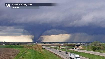
Tornado Touches Down in Lincoln, Omaha 35M Under Severe Threat
A tornado touched down in Lincoln, NE, just b
26 Apr 2024 11:25 PM
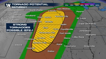
Weekend Forecast: More Severe Weather, Flash Flooding
If it seems like April has been particularly
26 Apr 2024 9:10 PM
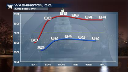
From frosty temps to Record Warmth in the Northeast
Temps are climbing in the Northeast, and by e
26 Apr 2024 9:10 PM
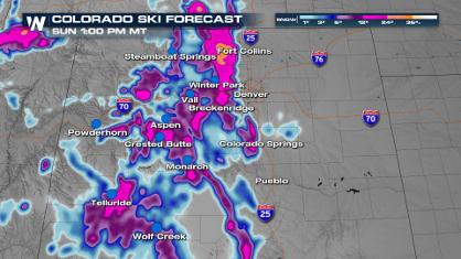
Spring Snow on the Horizon in Colorado
Snow is on the way for the Intermountain West
26 Apr 2024 9:05 PM
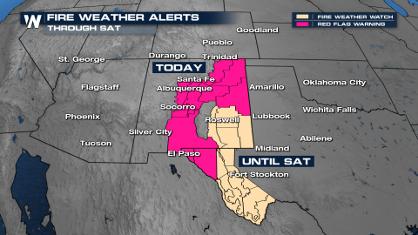
Critical Fire Risk in West Texas, New Mexico
A critical fire risk is in place for west Tex
26 Apr 2024 2:15 PM

NOAA Debuts "HeatRisk" Tool Nationwide
More people die from heat every year than ALL
25 Apr 2024 9:00 PM

Double Trouble: Cicadas Take to the Skies this Spring
It’s the soundtrack to the summer. Nature’s n
25 Apr 2024 8:45 PM