Revolutionizing How Ground Elevations are Measured for Flood Heights
Special Stories
26 Mar 2019 3:09 AM
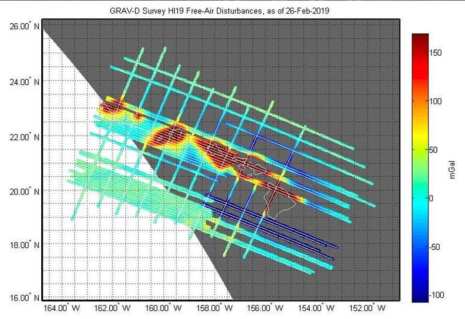
[A partially-completed gravity survey map flown by NOAA’s Gulfstream IV aircraft to survey the gravity field over Hawaii in February, 2019. While the aircraft flies back and forth in a grid pattern, a NGS scientist aboard uses scientific equipment to survey the geopotential for the entire state and surrounding coastal ocean. The complex process of geodetic leveling that measures geopotential is a measurement of height times the change in gravity at a given point. Gravity has to be accounted for when taking elevation measurements because the Earth's gravity field varies from point to point. These variations affect how water flows.]
[NOAA] Suppose you are buying a new home that is located near a river that routinely floods. During the buying process, you learn that you are required to have flood insurance. A step in the process of obtaining this insurance is to get a certified elevation of your new home from a professional surveyor. Wouldn’t it be easier (and cheaper) to simply provide your insurer with the elevation of your home? After all, it’s relatively easy to get this elevation information right from your mobile smartphone.
These days, it’s routine to use a smartphone and a mapping app to find out your elevation above sea level in the United States. Unfortunately, this height information is not very accurate. For casual use, it is generally good enough. But more accurate heights are required for many professional applications.
Particularly in low-lying coastal areas, this information is critical because professionals need to know how water will flow from point to point across the land. Experts who survey the elevations of houses, create flood zone maps, plot hurricane evacuation routes, or plan future coastal development to account for sea level rise all rely on accurate heights.
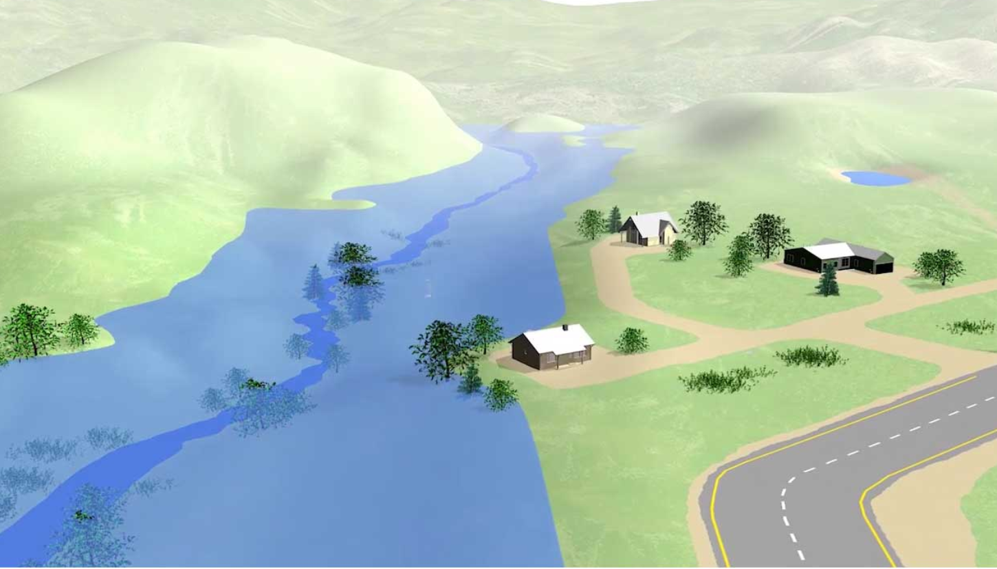
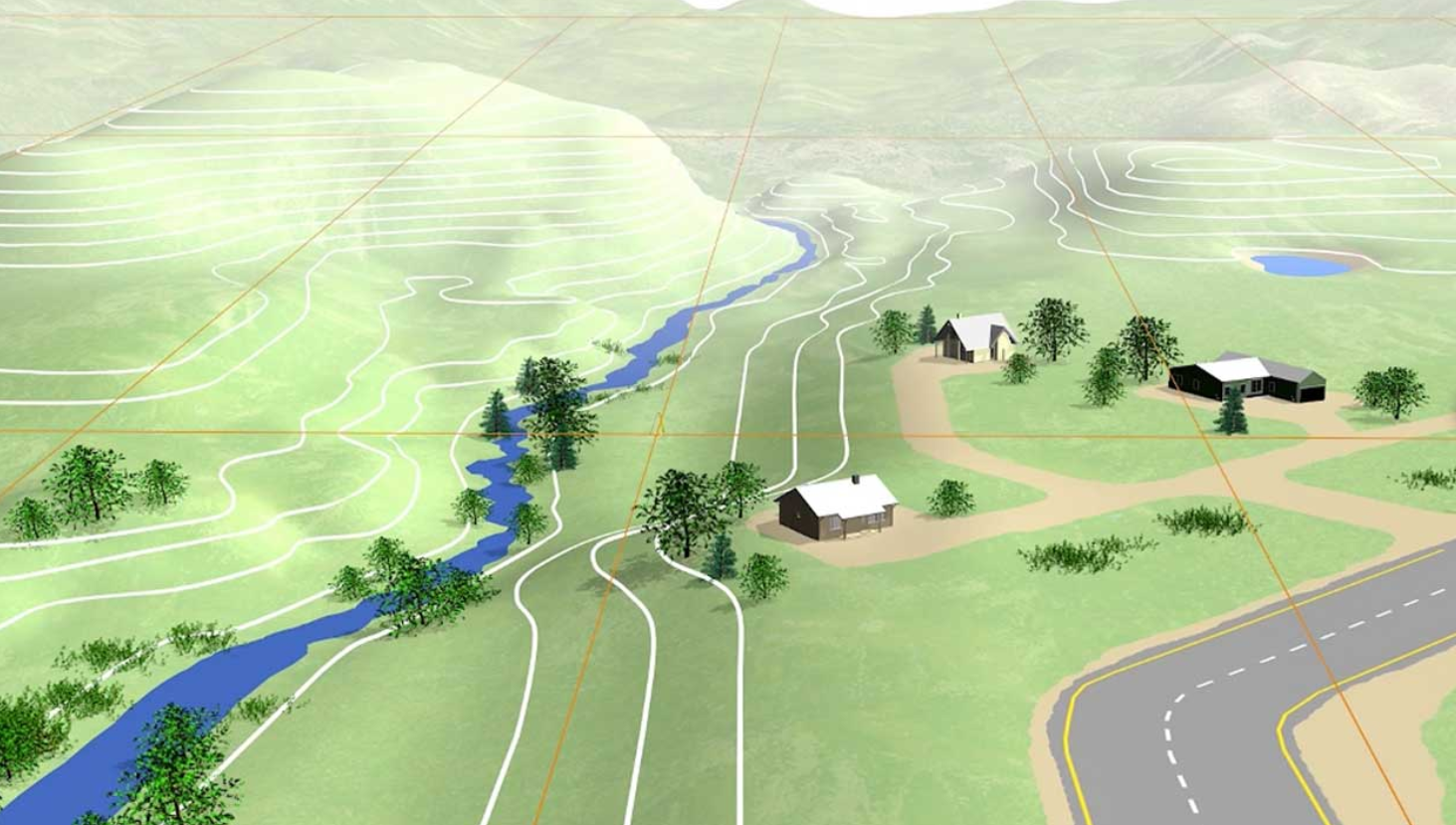 [This visualization depicts a valley and several houses before (above) and after (below) a flooding event. It shows how accurate heights are needed to understand how water flows across the land. Just a few inches of inaccuracy in measuring the height of the location of a house, for instance, could mean the difference between a flooded and a dry home.]
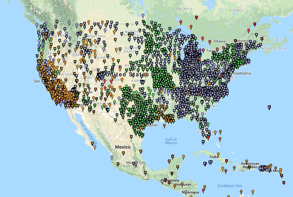 [NOAA's National Geodetic Survey defines and manages the National Spatial Reference System — a consistent coordinate system that defines latitude, longitude, height, scale, gravity, and orientation throughout the United States. In addition to a network of continuously operating reference stations supporting three-dimensional positioning activities (shown here), the reference system includes a network of permanently marked points; a consistent, accurate, and up-to-date national shoreline; and a set of accurate models describing dynamic, geophysical processes that affect spatial measurements.]
All of these large and small variations to the size, shape, and mass distribution of the earth cause slight variations in the strength of gravity in different places around the globe. These variations determine the shape of the planet’s water. This shape is what we call global sea level.
Think of it this way: If we could remove the tides and currents from the ocean, it would settle into a smoothly undulating shape (rising where gravity is high, sinking where gravity is low). This irregular shape is called “the geoid.” It is the surface which defines zero elevation. Using complex math and gravity readings on land, surveyors extend this imaginary line through the continents. And this model is used to measure surface elevations.
[NOAA's National Geodetic Survey defines and manages the National Spatial Reference System — a consistent coordinate system that defines latitude, longitude, height, scale, gravity, and orientation throughout the United States. In addition to a network of continuously operating reference stations supporting three-dimensional positioning activities (shown here), the reference system includes a network of permanently marked points; a consistent, accurate, and up-to-date national shoreline; and a set of accurate models describing dynamic, geophysical processes that affect spatial measurements.]
All of these large and small variations to the size, shape, and mass distribution of the earth cause slight variations in the strength of gravity in different places around the globe. These variations determine the shape of the planet’s water. This shape is what we call global sea level.
Think of it this way: If we could remove the tides and currents from the ocean, it would settle into a smoothly undulating shape (rising where gravity is high, sinking where gravity is low). This irregular shape is called “the geoid.” It is the surface which defines zero elevation. Using complex math and gravity readings on land, surveyors extend this imaginary line through the continents. And this model is used to measure surface elevations.
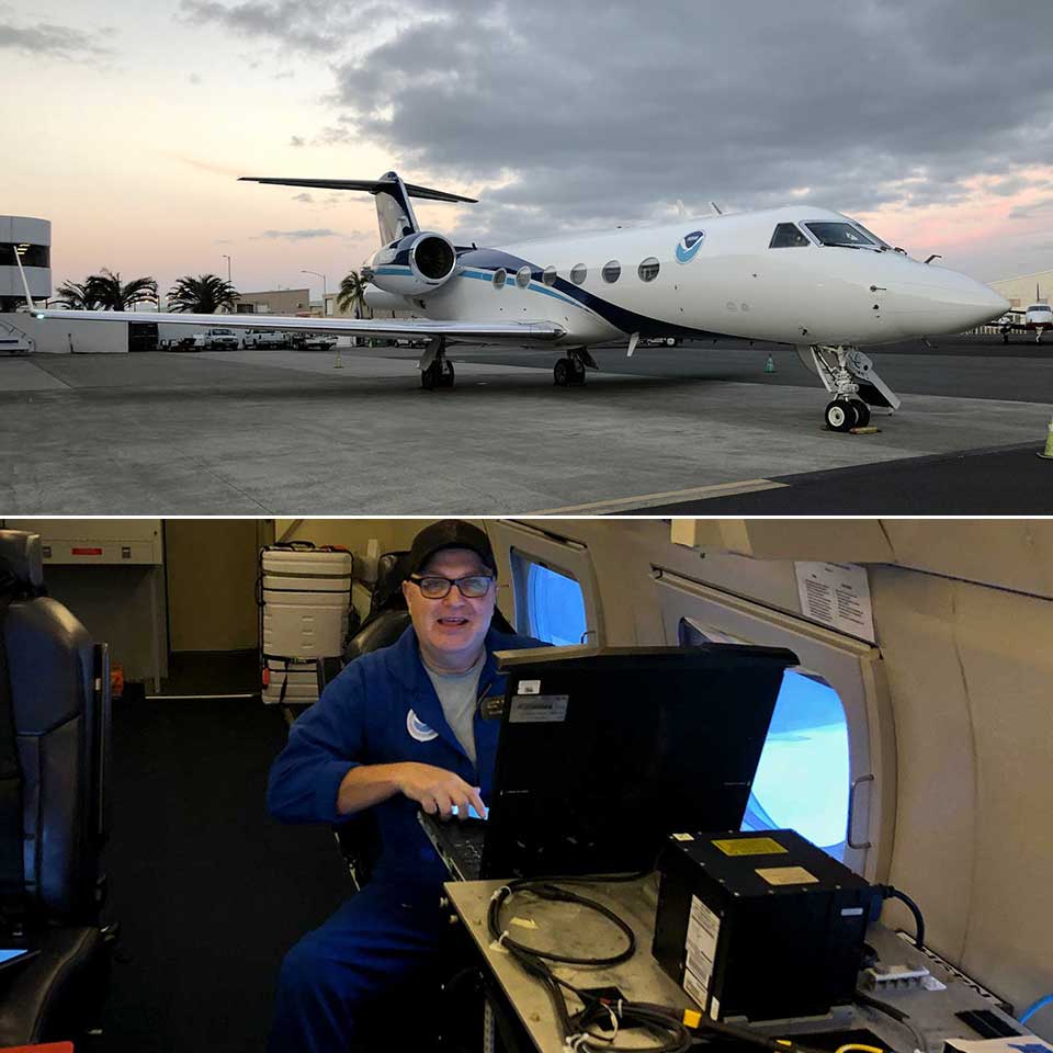 [National Geodetic Survey survey technician Justin Dahlberg collects gravity measurements aboard NOAA’s Gulfstream IV aircraft, shown in top image, over the Hawaiian Islands in February, 2019.]
More accurate measurements are expected to pay big dividends. A recent study estimated that this project, the Gravity for the Redefinition of the American Vertical Datum (GRAV-D for short), will provide about $4.8 billion in social and economic benefits to the nation over 15 years through improved floodplain mapping, coastal resource management, construction, agriculture, and emergency evacuation planning. The study estimates a savings of $2.2 billion in improved floodplain management alone, because better height measurements will result in less property damage from flooding events.
Surveying the entire gravity field of the United States, including its territories, to update the nation’s vertical datum is one of the most ambitious projects ever undertaken in the more than 150 year history of the National Geodetic Survey. While it’s not an easy task, the result will transform how we measure accurate heights for decades to come.
Edited for WeatherNation by Meteorologist Mace Michaels
[National Geodetic Survey survey technician Justin Dahlberg collects gravity measurements aboard NOAA’s Gulfstream IV aircraft, shown in top image, over the Hawaiian Islands in February, 2019.]
More accurate measurements are expected to pay big dividends. A recent study estimated that this project, the Gravity for the Redefinition of the American Vertical Datum (GRAV-D for short), will provide about $4.8 billion in social and economic benefits to the nation over 15 years through improved floodplain mapping, coastal resource management, construction, agriculture, and emergency evacuation planning. The study estimates a savings of $2.2 billion in improved floodplain management alone, because better height measurements will result in less property damage from flooding events.
Surveying the entire gravity field of the United States, including its territories, to update the nation’s vertical datum is one of the most ambitious projects ever undertaken in the more than 150 year history of the National Geodetic Survey. While it’s not an easy task, the result will transform how we measure accurate heights for decades to come.
Edited for WeatherNation by Meteorologist Mace Michaels
[This visualization depicts a valley and several houses before (above) and after (below) a flooding event. It shows how accurate heights are needed to understand how water flows across the land. Just a few inches of inaccuracy in measuring the height of the location of a house, for instance, could mean the difference between a flooded and a dry home.]
Meet the Vertical Datum
This is where NOAA’s National Geodetic Survey (NGS) enters the picture. Scientists at NGS maintain a nationwide coordinate system that defines latitude, longitude, height, scale, gravity, orientation, and the national shoreline throughout the United States. This reference system ensures that those who need accurate positioning information — whether they are in Alaska or Guam or Key West — are all working from the same reference points. The height component of this nationwide system is called the vertical datum. This datum is a collection of specific points on the Earth with known heights either above or below mean sea level.Sea Level is Lumpy and Irregular
Measuring elevation is more complex than most people realize. It sounds easy enough: the elevation of a point on land is a measurement of how high it is above sea level, right? The problem is that sea level is not level at all: it is lumpy and irregular. If the Earth were a perfect sphere with no mountains or valleys, sea level would also be the same everywhere. But the Earth, of course, is far from uniform. The Earth bulges at the equator due to the long-term effects of the earth’s rotation. And, at a smaller scale, topography also affects the mass of the Earth at different locations — a mountain has more mass than a valley, so the pull of gravity is stronger near mountains.
[NOAA's National Geodetic Survey defines and manages the National Spatial Reference System — a consistent coordinate system that defines latitude, longitude, height, scale, gravity, and orientation throughout the United States. In addition to a network of continuously operating reference stations supporting three-dimensional positioning activities (shown here), the reference system includes a network of permanently marked points; a consistent, accurate, and up-to-date national shoreline; and a set of accurate models describing dynamic, geophysical processes that affect spatial measurements.]
All of these large and small variations to the size, shape, and mass distribution of the earth cause slight variations in the strength of gravity in different places around the globe. These variations determine the shape of the planet’s water. This shape is what we call global sea level.
Think of it this way: If we could remove the tides and currents from the ocean, it would settle into a smoothly undulating shape (rising where gravity is high, sinking where gravity is low). This irregular shape is called “the geoid.” It is the surface which defines zero elevation. Using complex math and gravity readings on land, surveyors extend this imaginary line through the continents. And this model is used to measure surface elevations.
Reaching New Heights
How we calculate accurate heights based on mean sea level today is good, but it’s quite complicated, expensive, and time-consuming. Scientists at NGS are in the midst of a 15-year project to make accurate height measurement dramatically better. The result will be a new vertical datum, slated to be released in 2022, that will allow users to calculate heights to within about an inch for most locations around the nation. The new model will not only give more accurate height measurements, it will serve as the baseline to update height data over time as gravity values around the nation shift with the changing landscape of the Earth. The new model will also be tied into GPS, so it will be easier than ever to get accurate height information. Last but not least, users will be able to see more easily how heights are changing over time for a given area. That’s a big deal when monitoring things like levee heights, hurricane evacuation routes, or the elevation of your home.
[National Geodetic Survey survey technician Justin Dahlberg collects gravity measurements aboard NOAA’s Gulfstream IV aircraft, shown in top image, over the Hawaiian Islands in February, 2019.]
More accurate measurements are expected to pay big dividends. A recent study estimated that this project, the Gravity for the Redefinition of the American Vertical Datum (GRAV-D for short), will provide about $4.8 billion in social and economic benefits to the nation over 15 years through improved floodplain mapping, coastal resource management, construction, agriculture, and emergency evacuation planning. The study estimates a savings of $2.2 billion in improved floodplain management alone, because better height measurements will result in less property damage from flooding events.
Surveying the entire gravity field of the United States, including its territories, to update the nation’s vertical datum is one of the most ambitious projects ever undertaken in the more than 150 year history of the National Geodetic Survey. While it’s not an easy task, the result will transform how we measure accurate heights for decades to come.
Edited for WeatherNation by Meteorologist Mace MichaelsAll Weather News
More
Spring Snow on the Horizon in Colorado
Snow is on the way for the mountains of Color
26 Apr 2024 12:10 PM
Weekend Forecast: More Severe Weather
With another severe weather outbreak underway
26 Apr 2024 12:05 PM
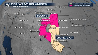
Critical Fire Risk in West Texas, New Mexico
A critical fire risk is in place for west Tex
26 Apr 2024 12:00 PM

National Park Week: Get Out and Explore
National Park Week started Saturday, April 20
26 Apr 2024 11:55 AM

NOAA Debuts "HeatRisk" Tool Nationwide
More people die from heat every year than ALL
25 Apr 2024 9:00 PM

Double Trouble: Cicadas Take to the Skies this Spring
It’s the soundtrack to the summer. Nature’s n
25 Apr 2024 8:45 PM