Study Shows Changes in Great Plains’ Ogallala Aquifer
Special Stories
21 Feb 2019 8:19 AM
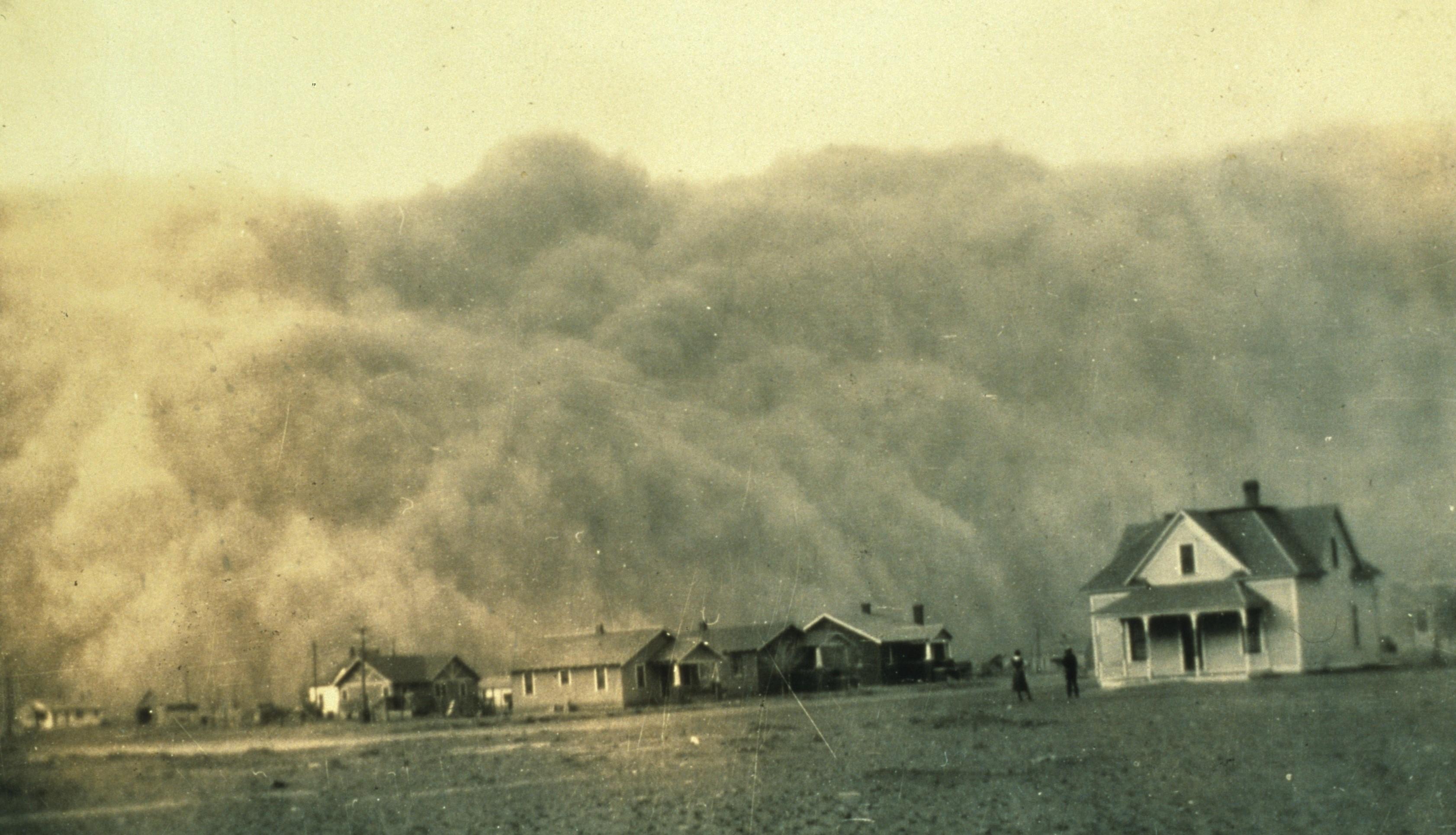
[Dust storm approaching Stratford, Texas during the Dust Bowl of the 1930s. Photo credit: NOAA George E. Marsh Album]
[NOAA by Michon Scott] The Ogallala Aquifer underlies parts of Colorado, Kansas, Nebraska, New Mexico, Oklahoma, South Dakota, Texas, and Wyoming. From wheat and cows to corn and cotton, the regional economy depends almost exclusively on agriculture irrigated by Ogallala groundwater. But according to the Fourth National Climate Assessment (NCA4), producers are extracting water faster than it is being replenished, which means that parts of the Ogallala Aquifer should be considered a nonrenewable resource.
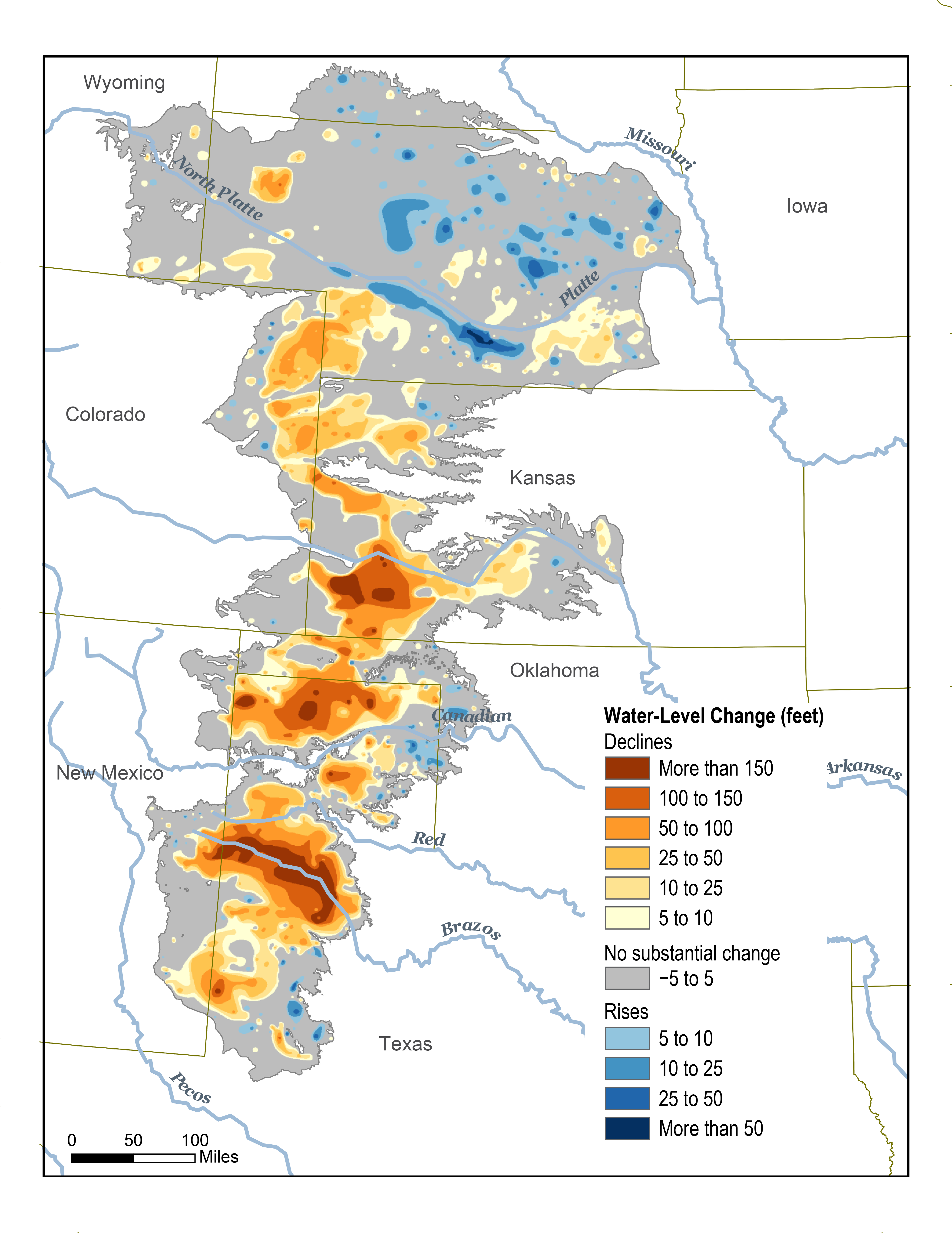
The map below shows changes in Ogallala water levels from the period before the aquifer was tapped to 2015. Declining levels appear in red and orange, and rising levels appear in shades of blue. The darker the color, the greater the change. Gray indicates no significant change. Although water levels have actually risen in some areas, especially Nebraska, water levels are mostly in decline, namely from Kansas southward.
 In the early twentieth century, farmers converted large stretches of the Great Plains from grassland to cropland. Drought and stress on the soils led to the 1930s Dust Bowl. Better soil conservation and irrigation techniques tamed the dust and boosted the regional economy. In 2007, the market value from the Ogallala region's agricultural products totaled roughly $35 billion. However, well outputs in the central and southern parts of the aquifer are declining due to excessive pumping, and prolonged droughts have parched the area, bringing back Dust Bowl-style storms, according to the NCA4.
The Agriculture chapter of NCA4 describes the risks and opportunities for resilience across the Ogallala region: "Recent advances in precision irrigation technologies, improved understanding of the impacts of different dryland and irrigation management strategies on crop productivity, and the adoption of weather-based irrigation scheduling tools as well as drought-tolerant crop varieties have increased the ability to cope with projected heat stress and drought conditions under climate change. However, current extraction for irrigation far exceeds recharge in this aquifer, and climate change places additional pressure on this critical water resource."
Edited for WeatherNation by Meteorologist Mace Michaels
In the early twentieth century, farmers converted large stretches of the Great Plains from grassland to cropland. Drought and stress on the soils led to the 1930s Dust Bowl. Better soil conservation and irrigation techniques tamed the dust and boosted the regional economy. In 2007, the market value from the Ogallala region's agricultural products totaled roughly $35 billion. However, well outputs in the central and southern parts of the aquifer are declining due to excessive pumping, and prolonged droughts have parched the area, bringing back Dust Bowl-style storms, according to the NCA4.
The Agriculture chapter of NCA4 describes the risks and opportunities for resilience across the Ogallala region: "Recent advances in precision irrigation technologies, improved understanding of the impacts of different dryland and irrigation management strategies on crop productivity, and the adoption of weather-based irrigation scheduling tools as well as drought-tolerant crop varieties have increased the ability to cope with projected heat stress and drought conditions under climate change. However, current extraction for irrigation far exceeds recharge in this aquifer, and climate change places additional pressure on this critical water resource."
Edited for WeatherNation by Meteorologist Mace MichaelsAll Weather News
More
Spring Snow on the Horizon in Colorado
Snow is on the way for the mountains of Color
26 Apr 2024 2:00 AM
Weekend Forecast: More Severe Weather
We are looking at the threat of another sever
26 Apr 2024 1:45 AM
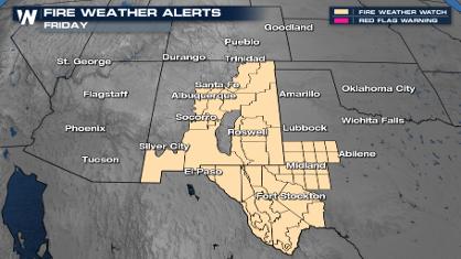
Critical Fire Risk in West Texas, New Mexico
A critical fire risk is in place for west Tex
26 Apr 2024 1:40 AM
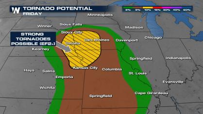
Significant Storm Threat Tonight, Friday
The spring season often means rounds of inten
26 Apr 2024 1:35 AM

National Park Week: Get Out and Explore
National Park Week started Saturday, April 20
25 Apr 2024 9:30 PM

NOAA Debuts "HeatRisk" Tool Nationwide
More people die from heat every year than ALL
25 Apr 2024 9:00 PM

Double Trouble: Cicadas Take to the Skies this Spring
It’s the soundtrack to the summer. Nature’s n
25 Apr 2024 8:45 PM