Using GOES Satellites to Map the California Wildfires
Special Stories
13 Nov 2018 9:06 AM
[NASA] California continues to be plagued by wildfires — including the Woolsey Fire near Los Angeles and the Camp Fire in Northern California, now one of the deadliest in the state's history. NASA satellites are observing these fires — and the damage they're leaving behind — from space.
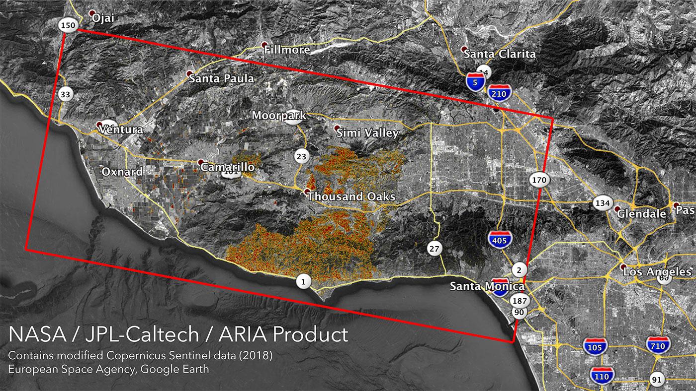
The Advanced Rapid Imaging and Analysis (ARIA) team at NASA's Jet Propulsion Laboratory in Pasadena, California, produced new damage maps using synthetic aperture radar images from the Copernicus Sentinel-1 satellites. The first map shows areas likely damaged by the Woolsey Fire as of Sunday, Nov. 11. It covers an area of about 50 miles by 25 miles (80 km by 40 km) — framed by the red polygon. The color variation from yellow to red indicates increasing ground surface change, or damage.
 [The Advanced Rapid Imaging and Analysis (ARIA) team at NASA's Jet Propulsion Laboratory in Pasadena, California, created these Damage Proxy Maps (DPMs) depicting areas in California likely damaged by the Woolsey and Camp Fires.]
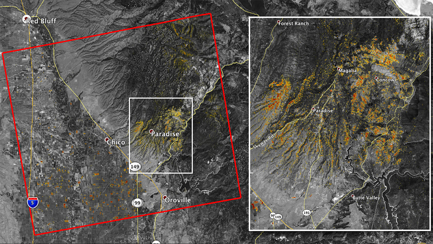
The second map (above) shows damage from the Camp Fire in Northern California as of Saturday, Nov. 10. It depicts an area of about 55 miles by 48 miles (88 km by 77 km) and includes the city of Paradise, one of the most devastated areas. Like the previous map, red areas show the most severe surface change, or damage. The ARIA team compared the data for both images to the Google Crisismap for preliminary validation.
Although the maps may be less reliable over vegetated terrain, like farmland, they can help officials and first responders identify heavily damaged areas and allocate resources as needed.
[The Advanced Rapid Imaging and Analysis (ARIA) team at NASA's Jet Propulsion Laboratory in Pasadena, California, created these Damage Proxy Maps (DPMs) depicting areas in California likely damaged by the Woolsey and Camp Fires.]
The second map (above) shows damage from the Camp Fire in Northern California as of Saturday, Nov. 10. It depicts an area of about 55 miles by 48 miles (88 km by 77 km) and includes the city of Paradise, one of the most devastated areas. Like the previous map, red areas show the most severe surface change, or damage. The ARIA team compared the data for both images to the Google Crisismap for preliminary validation.
Although the maps may be less reliable over vegetated terrain, like farmland, they can help officials and first responders identify heavily damaged areas and allocate resources as needed.
 More information about ARIA is available at https://aria.jpl.nasa.gov/
Edited for WeatherNation by Meteorologist Mace Michaels
More information about ARIA is available at https://aria.jpl.nasa.gov/
Edited for WeatherNation by Meteorologist Mace Michaels
[The Advanced Rapid Imaging and Analysis (ARIA) team at NASA's Jet Propulsion Laboratory in Pasadena, California, created these Damage Proxy Maps (DPMs) depicting areas in California likely damaged by the Woolsey and Camp Fires.]
The second map (above) shows damage from the Camp Fire in Northern California as of Saturday, Nov. 10. It depicts an area of about 55 miles by 48 miles (88 km by 77 km) and includes the city of Paradise, one of the most devastated areas. Like the previous map, red areas show the most severe surface change, or damage. The ARIA team compared the data for both images to the Google Crisismap for preliminary validation.
Although the maps may be less reliable over vegetated terrain, like farmland, they can help officials and first responders identify heavily damaged areas and allocate resources as needed.
More information about ARIA is available at https://aria.jpl.nasa.gov/
Edited for WeatherNation by Meteorologist Mace MichaelsAll Weather News
More
Spring Snow on the Horizon in Colorado
Snow is on the way for the mountains of Color
26 Apr 2024 3:00 AM
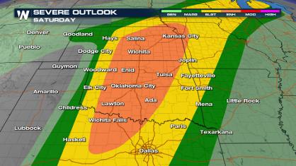
Weekend Forecast: More Severe Weather
We are looking at the threat of another sever
26 Apr 2024 2:45 AM
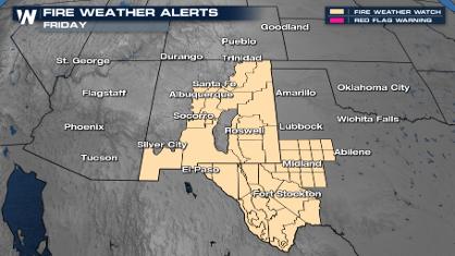
Critical Fire Risk in West Texas, New Mexico
A critical fire risk is in place for west Tex
26 Apr 2024 2:40 AM
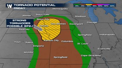
Significant Storm Threat Tonight, Friday
The spring season often means rounds of inten
26 Apr 2024 2:35 AM

National Park Week: Get Out and Explore
National Park Week started Saturday, April 20
25 Apr 2024 9:30 PM

NOAA Debuts "HeatRisk" Tool Nationwide
More people die from heat every year than ALL
25 Apr 2024 9:00 PM

Double Trouble: Cicadas Take to the Skies this Spring
It’s the soundtrack to the summer. Nature’s n
25 Apr 2024 8:45 PM