The Flooded Locations & Simulated Hydrographs Project Improves Flash Flood Forecasts
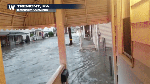
Flash floods — raging torrents of water caused by heavy rainfall and overtopped rivers and streams — can become deadly in a matter of minutes. The rapid increases of water in streams and creeks, typically in response to intense rainfall events, pose significant hazards to motorists, recreationalists, and infrastructure worldwide. The small space-time scales associated with flash floods have made it challenging to predict the precise locations of impending rainfall and resultant impacts.
Now, a new forecasting tool is helping NOAA meteorologists predict when and where these devastating events will occur. Developed by NOAA researchers, FLASH — short for the Flooded Locations and Simulated Hydrographs Project — combines real-time rainfall estimates with real-time surface models to supply forecasters better information and more confidence with which to issue flood warnings.
https://www.youtube.com/watch?v=yiROl_DOchoHow it works
FLASH gathers rainfall data from multiple radars, combines it with information about the type of surface where rain is falling and creates a highly detailed forecast for when specific rivers and streams will flood and by how much. FLASH also provides historical context, helping forecasters communicate the significance of a predicted flash flood.
FLASH was launched in early 2012 largely in response to the demonstration and real-time availability of high-resolution, accurate rainfall observations from the MRMS/Q3 project. FLASH introduces a new paradigm in flash flood prediction that uses the Multi-radar/Multi-sensing forcing and produces flash flood forecasts at 1-km/5-min resolution through direct, forward simulation. The primary goal of the FLASH project is to improve the accuracy, timing, and specificity of flash flood warnings in the US, thus saving lives and protecting infrastructure. The FLASH team is comprised of researchers and students who use an interdisciplinary and collaborative approach to achieve the goal.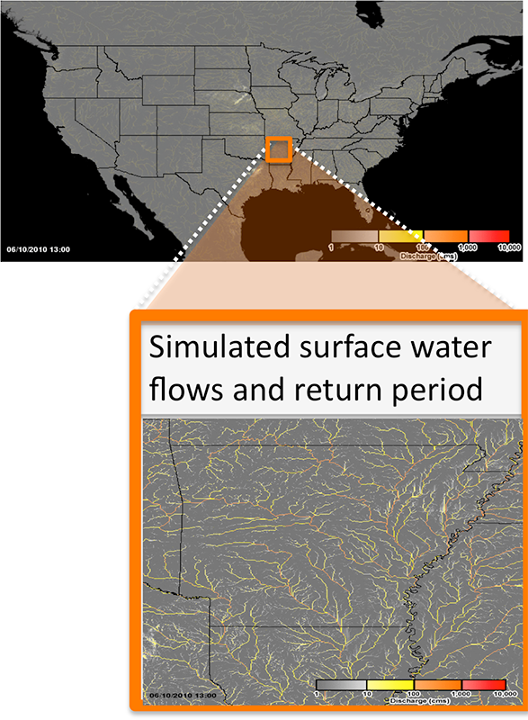 [The CREST hydrologic model is used to produce surface water fluxes at 1 km/5 min resolution. These discharges are converted to return periods using a long-term hindcast simulation with forcing from the gridded NEXRAD rainfall archive. From NOAA]
From its inception, FLASH has been designed within an Ensemble Framework For Flash Flood Forecasting to accommodate multiple forcings from rainfall observations to stormscale NWP forecasts, multiple model structures and parameter settings, and newly developed techniques for yielding probabilistic outputs. In the first implementation, FLASH relies on rainfall forcing from MRMS/Q3 to the CREST model run with a priori, physically based parameters. All hydrologic forecast products are produced at the same 1-km/5-min resolution as the rainfall forcing.
The availability of long-term, gridded rainfall archives provides for retrospective hydrologic simulation. At each grid point, the time series of historic simulations are used to evaluate the rarity or severity of model forecasts.
Edited for WeatherNation by Meteorologist Mace Michaels
[The CREST hydrologic model is used to produce surface water fluxes at 1 km/5 min resolution. These discharges are converted to return periods using a long-term hindcast simulation with forcing from the gridded NEXRAD rainfall archive. From NOAA]
From its inception, FLASH has been designed within an Ensemble Framework For Flash Flood Forecasting to accommodate multiple forcings from rainfall observations to stormscale NWP forecasts, multiple model structures and parameter settings, and newly developed techniques for yielding probabilistic outputs. In the first implementation, FLASH relies on rainfall forcing from MRMS/Q3 to the CREST model run with a priori, physically based parameters. All hydrologic forecast products are produced at the same 1-km/5-min resolution as the rainfall forcing.
The availability of long-term, gridded rainfall archives provides for retrospective hydrologic simulation. At each grid point, the time series of historic simulations are used to evaluate the rarity or severity of model forecasts.
Edited for WeatherNation by Meteorologist Mace Michaels


