Summer Outlook 2023: Warmer than Average in the SW and Wetter than Average in the SE
The Climate Prediction Center (CPC) has issued their Summer 2023 Outlook for precipitation and temperatures for the months of June, July and August. Before we dive into what the outlooks say, it is important to note that the darker colors indicate a higher level of confidence in above or below average conditions, NOT the degree to which we will be above or below average for the season.
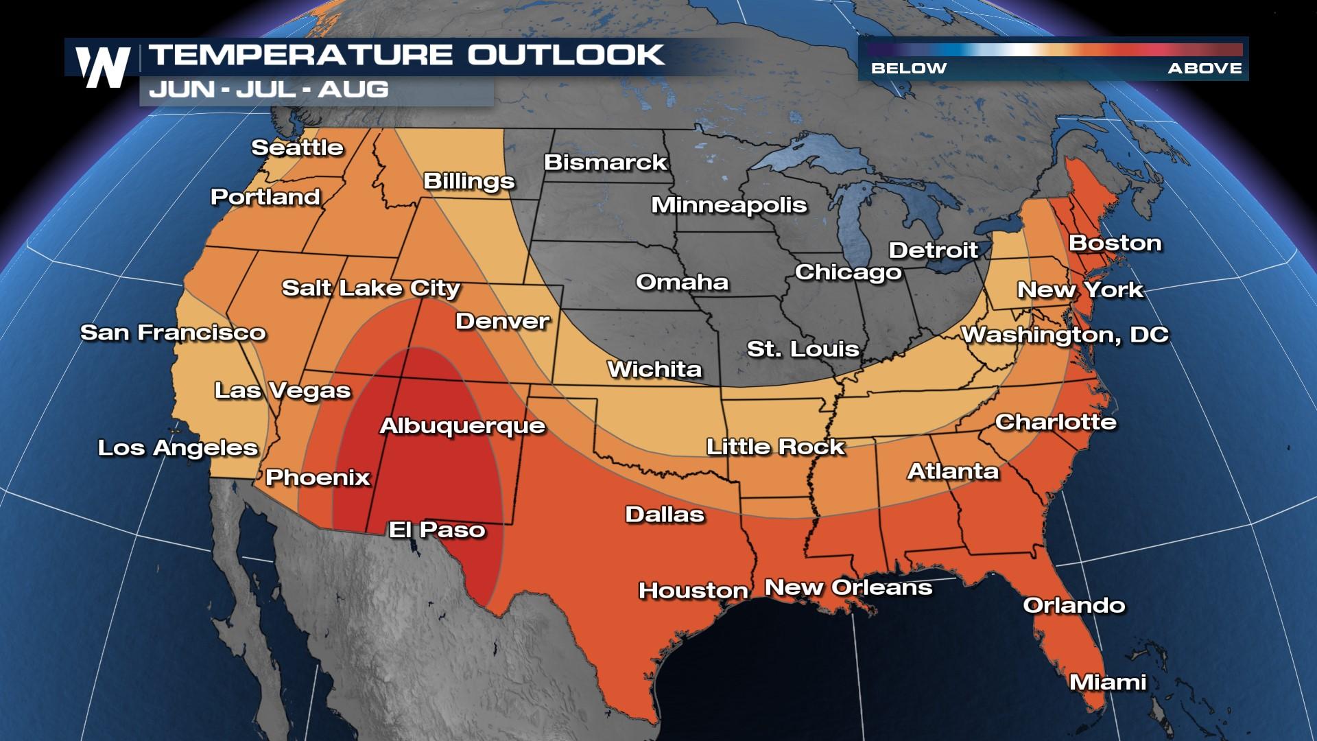
Temperatures
The CPC has high confidence in above average temperatures through the southern Four Corners and West Texas. This darkest color orange covers a 60% chance of above normal temperatures in this region. According to CPC, "The highest probabilities of above normal temperatures (60 to 70 percent) are over parts of the Southwest, Southern Rockies, and western Southern Plains". We see the same potential for above average temperatures (50%) through the entire Eastern Seaboard. Lesser potential for above average temperatures encompass much of the West Coast and Central Plains with likely average temperatures for much of the Upper Midwest and Great Lakes.
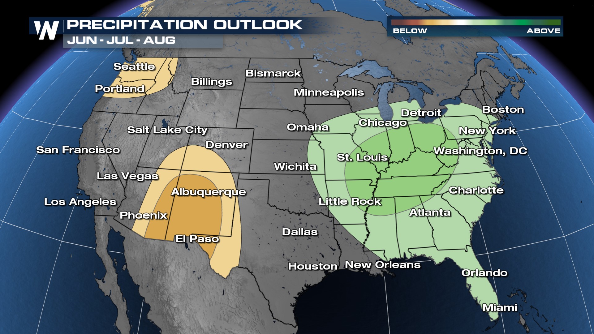
Precipitation
The precipitation outlook from the CPC calls for wetter than average conditions through the Ohio Valley and Mid-South with the potential for slightly above average precipitation in the summer months into the Lower Great Lakes region and into the Deep South. There is a large swath of the center of the country that will likely see average precipitation through the three month period. There is confidence in drier than normal conditions in the Desert Southwest and Pacific Northwest this summer.
 Drought Outlook
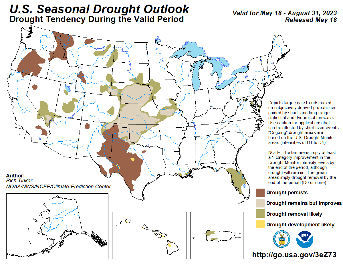
In addition to the seasonal temperature and precipitation outlooks, the CPC releases a seasonal drought outlook, summarizing where drought conditions may improve, worsen or remain the same. After peaking at drought coverage nationwide in October 2022 of 63%, drought coverage has steadily decreased over the last 6 months nationwide, with the most drastic improvements in the western U.S. thanks to repeated atmospheric river storms. Now, in mid-May, drought covers only 20% of the country.
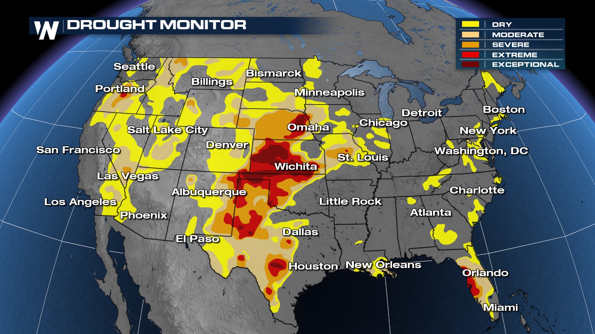 For the summer season, CPC is forecasting drought persistence in the western U.S. as a result of drier than average conditions expected there. This includes the PNW and northern Rockies. Drought is expected to remain in Great Plains of eastern WY, CO, and Nebraska and Kansas where normal precipitation chances won't be able to reverse drought but improve it slightly. We will likely see Florida's wet season and contribution from the monsoon pattern in the SW remove drought conditions in Nevada and the sunshine state. Drought will persist across West Texas and New Mexico with the potential for drought development in central Texas.
Conditions Behind the Outlook
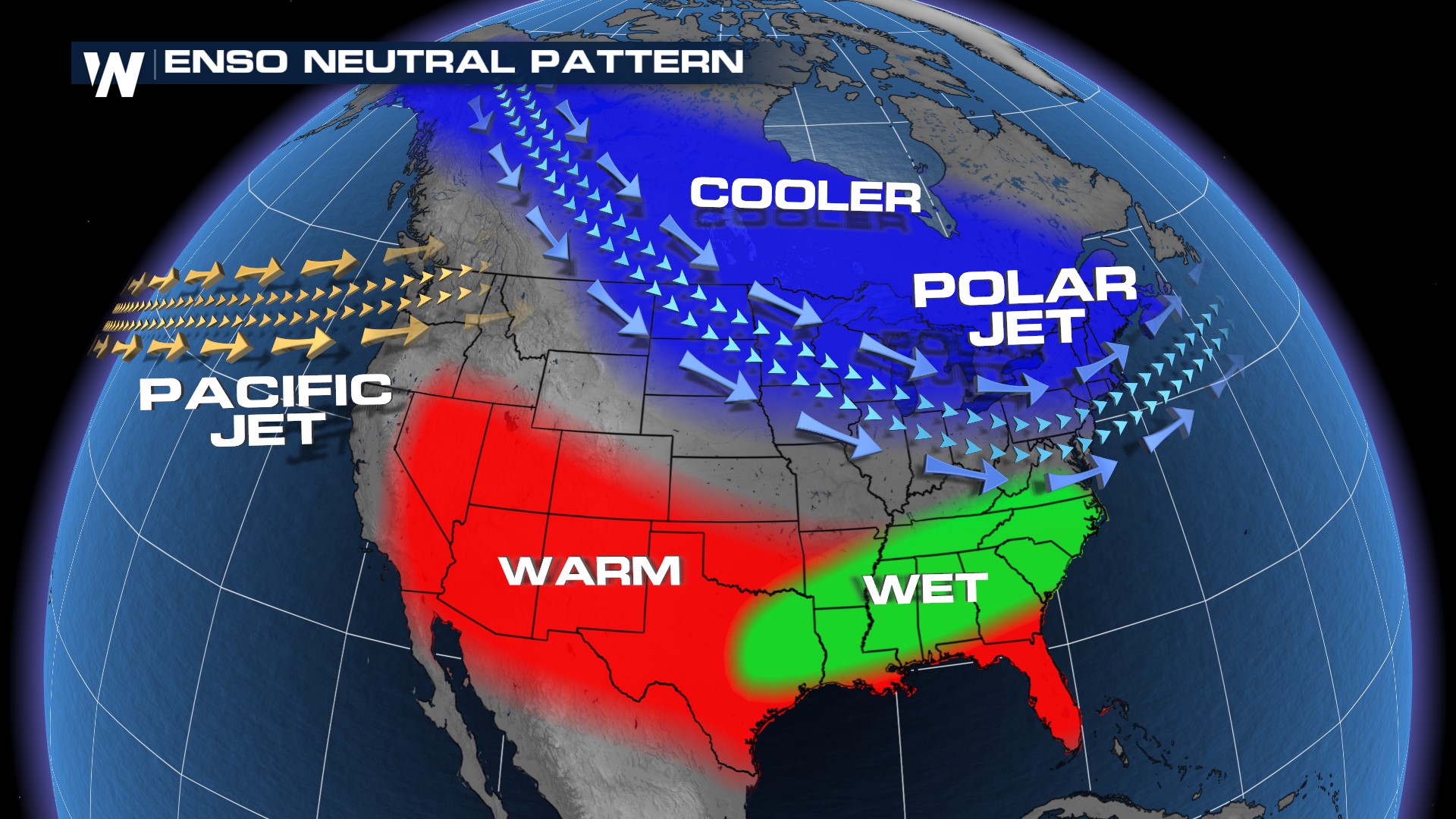
The seasonal outlooks are determined by large scale weather and atmospheric patterns, one of which is the ENSO, or El Niño Southern Oscillation, pattern which is the relationship between ocean and atmospheric temperatures in the equatorial Pacific Ocean. The last three years we have been in a La Niña season which is characterized by cooler than average ocean temperatures. La Niña seasons typically have active Atlantic Hurricane conditions.
The CPC announced earlier this year that we are officially in ENSO neutral conditions with little variance in the ocean and atmospheric temperatures in the E. Pacific. While forecasters anticipate El Niño to develop in the next few months, the neutral conditions are expected to continue through the summer months. When we look at a typical "ENSO Neutral Pattern" the seasonal outlooks above parallel typical ENSO neutral seasons. Typically, the ENSO pattern is most pronounced during the winter months, but we can see the influence year round.
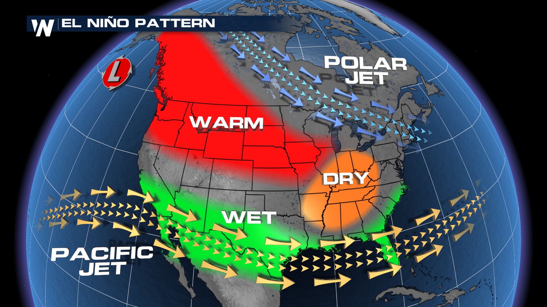
 Headed into the fall and winter months, there is high confidence from forecasters at the CPC (above 90% confidence) that we will transition to El Niño conditions in the Northern Hemisphere, where sea surface temperatures in the Equatorial Pacific Ocean will be above average. El Niño patterns typically spell wetter than average conditions for the southern U.S., while warmer than average conditions are experienced in the northern and western United States.
 Remember, these are just outlooks and are meant to help look at the global weather pattern. Individual weather systems are more impactful for day to day life, so stay with WeatherNation as we continue to keep you updated on the latest weather stories, always streaming 24/7.


