The Latest Alerts For The Nor'easter
Top Stories
26 Oct 2018 1:59 PM
Local National Weather Service offices continue to issue alerts Friday in advance of the first nor'easter of the fall/winter season.
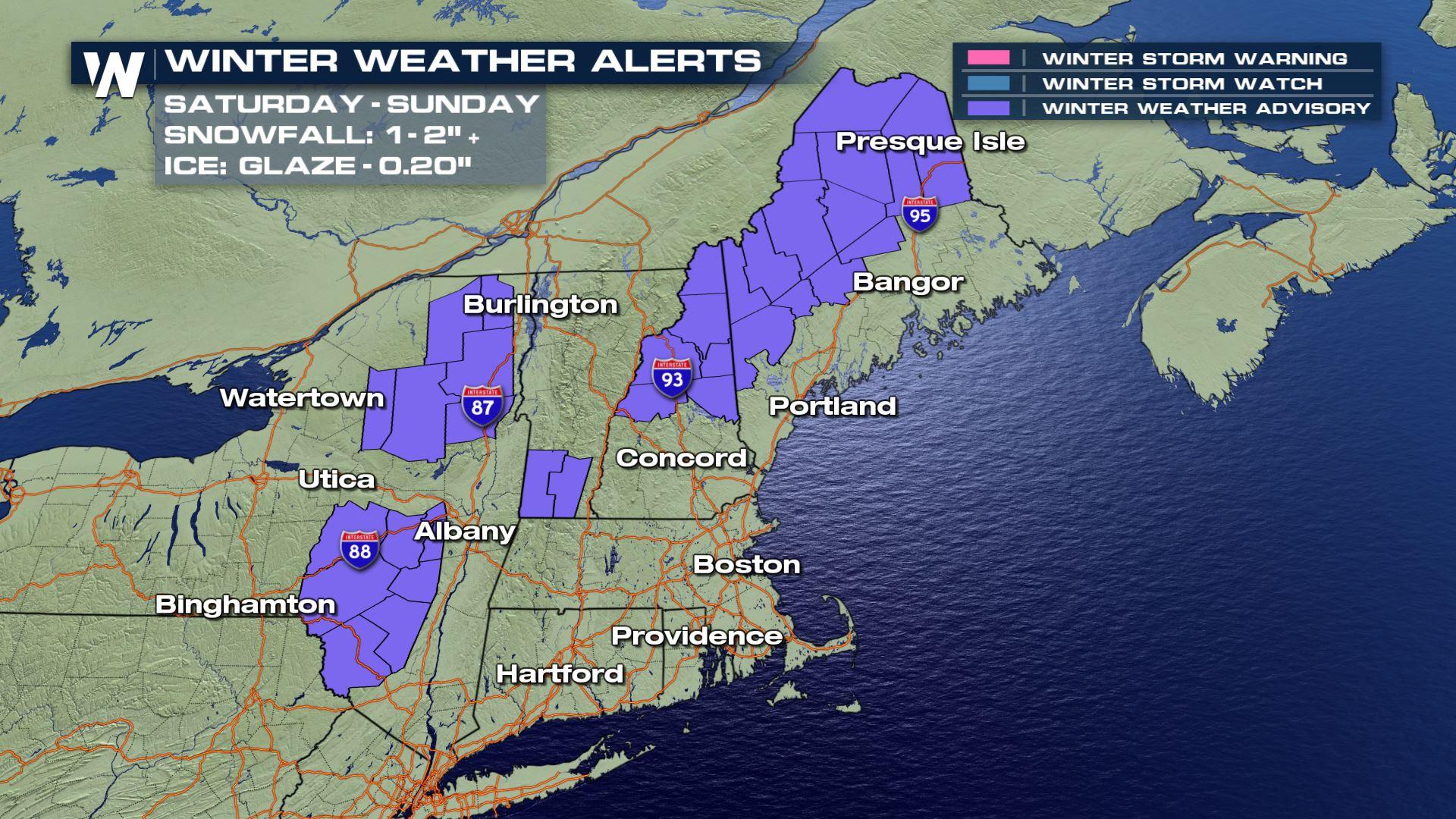
NEW as of 4 p.m. ET Friday, we now have Winter Weather Alerts!
 Saturday morning and then again Saturday night into Sunday morning will be the two time windows to expect a wintry mix of snow, sleet and freezing rain. The heaviest snow will be in New Hampshire and Maine (up to five inches!) while the lightest ice (but enough to make it slick) will be in New York.
See all those leaves out there? Well, that's going to contribute to a flooding concern...
Saturday morning and then again Saturday night into Sunday morning will be the two time windows to expect a wintry mix of snow, sleet and freezing rain. The heaviest snow will be in New Hampshire and Maine (up to five inches!) while the lightest ice (but enough to make it slick) will be in New York.
See all those leaves out there? Well, that's going to contribute to a flooding concern...
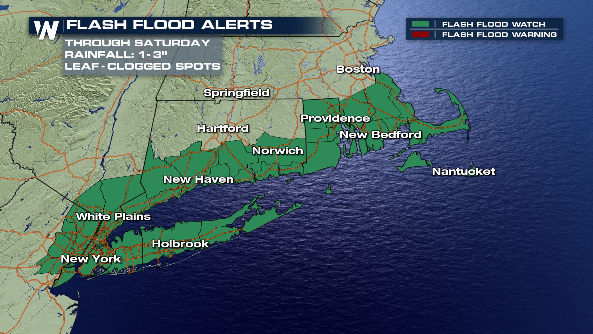 Clear your gutters and storm drains before the storm, as fallen foliage is expected to clog these areas and possibly lead to flooding.
The following alerts cover all weather concerns for offshore waters including big waves, gusty winds, but also for coastal flooding. Here are the latest coastal/wind alerts:
Clear your gutters and storm drains before the storm, as fallen foliage is expected to clog these areas and possibly lead to flooding.
The following alerts cover all weather concerns for offshore waters including big waves, gusty winds, but also for coastal flooding. Here are the latest coastal/wind alerts:
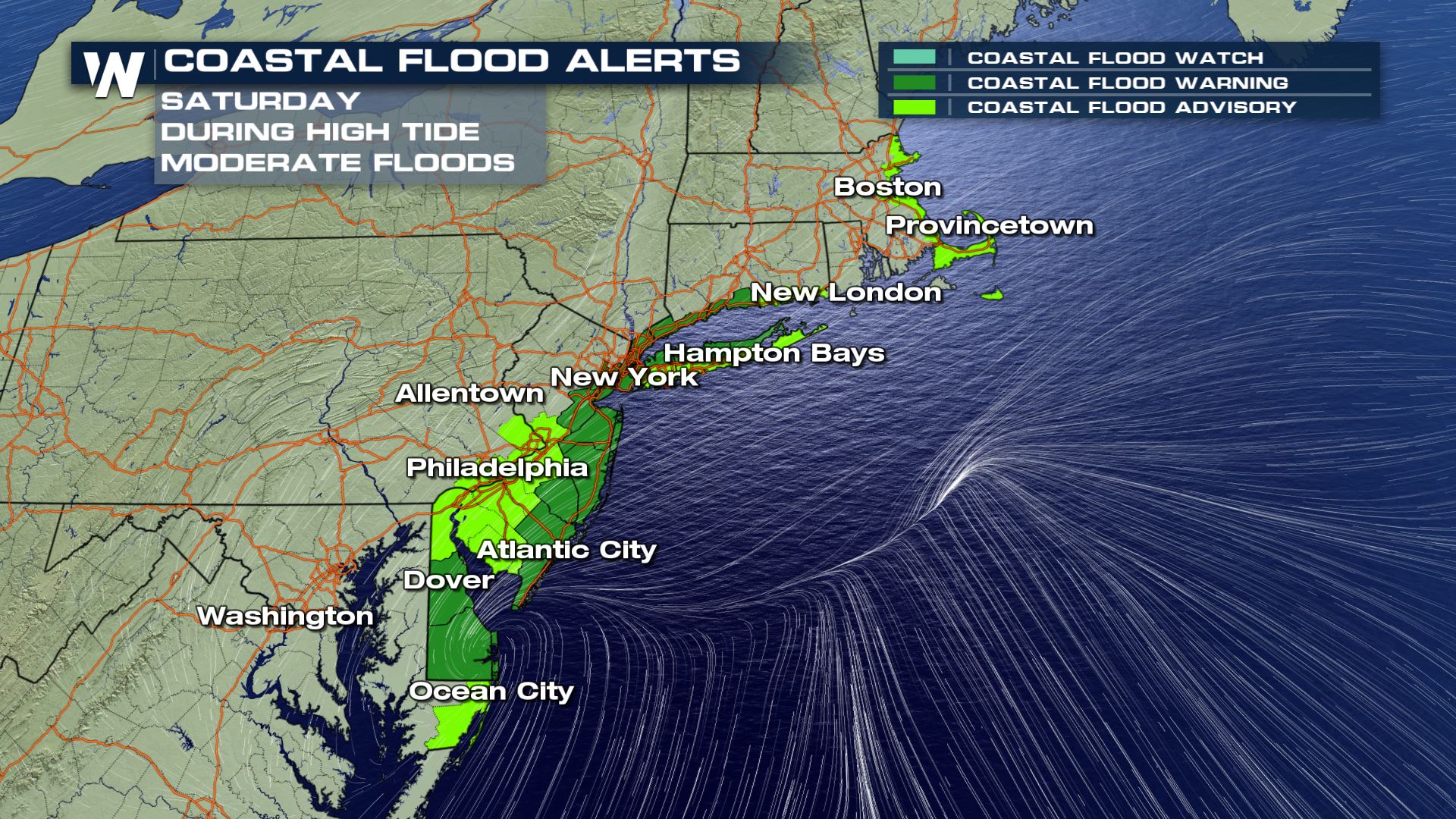 Coastal Flood alerts have been issued from Maryland to New England. Coastal flood alerts are issued when the combination of high tide, onshore winds and/or ongoing rainfall will contribute to flooding near the ocean. Vulnerable and low-lying areas near the coast can expect *moderate* flooding on Saturday. Check your local high tide time, because the forecast is for the high tide to be as much as 2 to 3 feet above normal on Saturday. The impacts here will be for closed roads and beach erosion.
The next alert we have is a Storm Warning:
Coastal Flood alerts have been issued from Maryland to New England. Coastal flood alerts are issued when the combination of high tide, onshore winds and/or ongoing rainfall will contribute to flooding near the ocean. Vulnerable and low-lying areas near the coast can expect *moderate* flooding on Saturday. Check your local high tide time, because the forecast is for the high tide to be as much as 2 to 3 feet above normal on Saturday. The impacts here will be for closed roads and beach erosion.
The next alert we have is a Storm Warning:
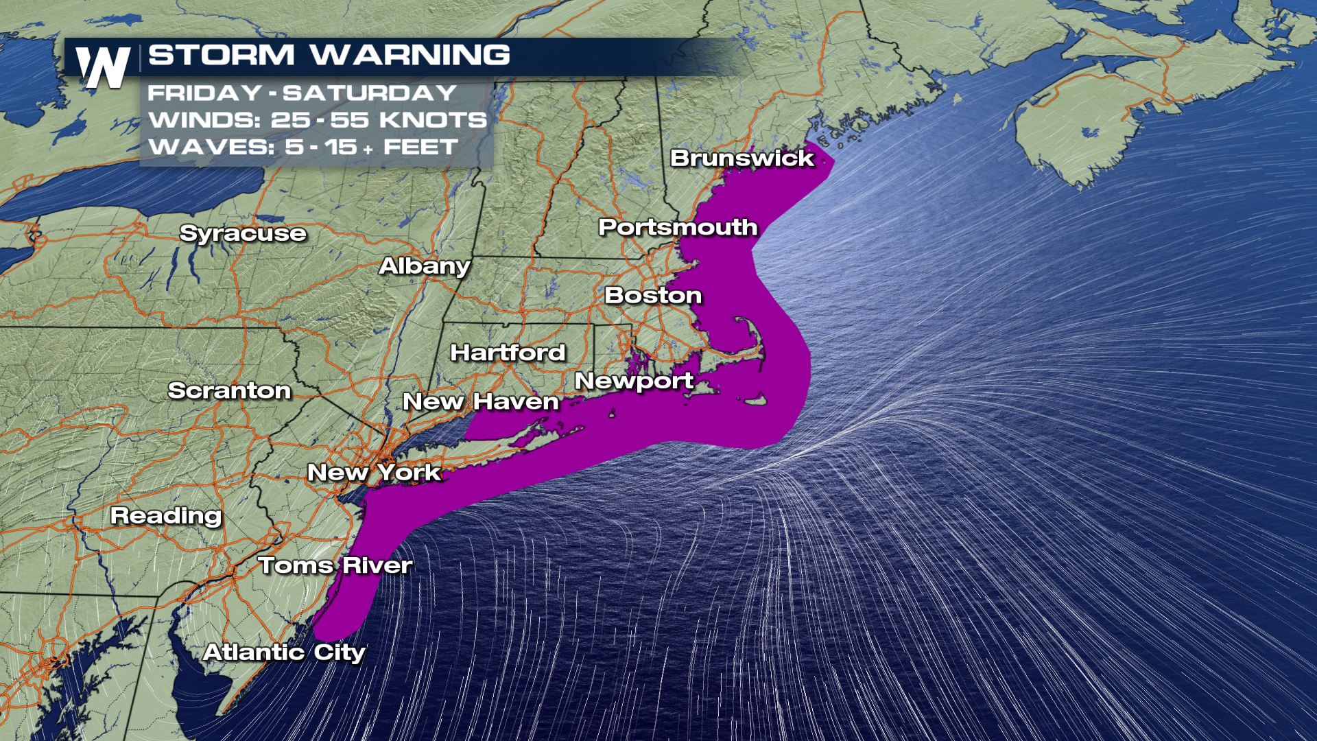 The National Weather Service issues a Storm Warning when the risk of storm force winds of 48 to 63 knots (or 55 to 75 mph) are expected. It is intended mainly for mariners and offshore water hazards for extreme winds. You should strongly consider avoiding the water as this nor'easter moves by.
Next up, wind alerts on land have been issued: *These are very important!*
[Related article: Blustery Winds, Travel Delays Expected in the Northeast]
The National Weather Service issues a Storm Warning when the risk of storm force winds of 48 to 63 knots (or 55 to 75 mph) are expected. It is intended mainly for mariners and offshore water hazards for extreme winds. You should strongly consider avoiding the water as this nor'easter moves by.
Next up, wind alerts on land have been issued: *These are very important!*
[Related article: Blustery Winds, Travel Delays Expected in the Northeast]
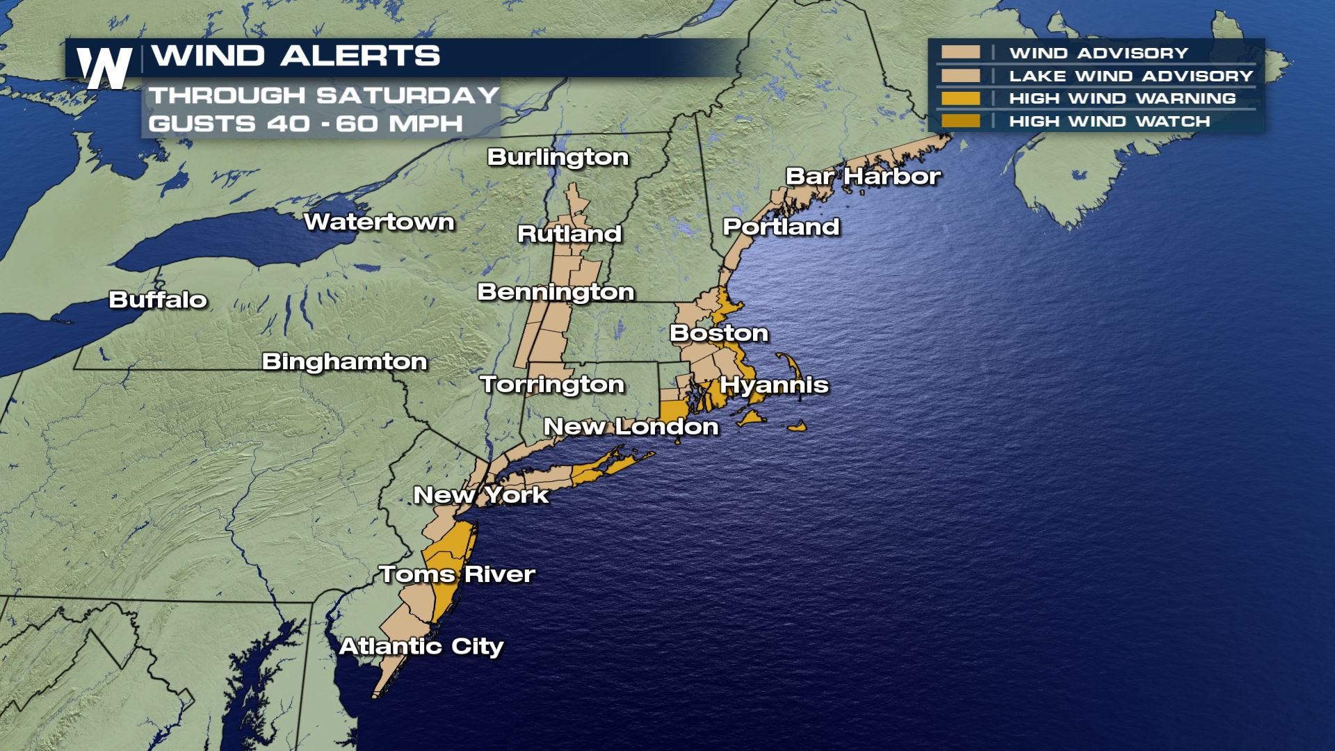 *This is very important because wind alerts bring a life-threatening danger* These winds can reach the same speed as severe thunderstorm warnings, though wind alerts may not get the same exposure and communication as a severe thunderstorm. Trees can come down on homes and cars, bringing that life-threatening danger. Keep these wind alerts in mind as you are out and about Saturday!
Winds over land are expected to be strong, gusting up to 60 mph in some areas highlighted. This could lead to scattered power outages through Saturday. Make sure you are prepared in case you are without power for any length of time. Outage will likely be brief, not long term.
We have written about the nor'easter coming. For much more detail, click here to go to our other story. Remember to stay with us for updates throughout the storm!
For WeatherNation, Meteorologist Steve Glazier
*This is very important because wind alerts bring a life-threatening danger* These winds can reach the same speed as severe thunderstorm warnings, though wind alerts may not get the same exposure and communication as a severe thunderstorm. Trees can come down on homes and cars, bringing that life-threatening danger. Keep these wind alerts in mind as you are out and about Saturday!
Winds over land are expected to be strong, gusting up to 60 mph in some areas highlighted. This could lead to scattered power outages through Saturday. Make sure you are prepared in case you are without power for any length of time. Outage will likely be brief, not long term.
We have written about the nor'easter coming. For much more detail, click here to go to our other story. Remember to stay with us for updates throughout the storm!
For WeatherNation, Meteorologist Steve Glazier
Saturday morning and then again Saturday night into Sunday morning will be the two time windows to expect a wintry mix of snow, sleet and freezing rain. The heaviest snow will be in New Hampshire and Maine (up to five inches!) while the lightest ice (but enough to make it slick) will be in New York.
See all those leaves out there? Well, that's going to contribute to a flooding concern...
Clear your gutters and storm drains before the storm, as fallen foliage is expected to clog these areas and possibly lead to flooding.
The following alerts cover all weather concerns for offshore waters including big waves, gusty winds, but also for coastal flooding. Here are the latest coastal/wind alerts:
Coastal Flood alerts have been issued from Maryland to New England. Coastal flood alerts are issued when the combination of high tide, onshore winds and/or ongoing rainfall will contribute to flooding near the ocean. Vulnerable and low-lying areas near the coast can expect *moderate* flooding on Saturday. Check your local high tide time, because the forecast is for the high tide to be as much as 2 to 3 feet above normal on Saturday. The impacts here will be for closed roads and beach erosion.
The next alert we have is a Storm Warning:
The National Weather Service issues a Storm Warning when the risk of storm force winds of 48 to 63 knots (or 55 to 75 mph) are expected. It is intended mainly for mariners and offshore water hazards for extreme winds. You should strongly consider avoiding the water as this nor'easter moves by.
Next up, wind alerts on land have been issued: *These are very important!*
[Related article: Blustery Winds, Travel Delays Expected in the Northeast]
*This is very important because wind alerts bring a life-threatening danger* These winds can reach the same speed as severe thunderstorm warnings, though wind alerts may not get the same exposure and communication as a severe thunderstorm. Trees can come down on homes and cars, bringing that life-threatening danger. Keep these wind alerts in mind as you are out and about Saturday!
Winds over land are expected to be strong, gusting up to 60 mph in some areas highlighted. This could lead to scattered power outages through Saturday. Make sure you are prepared in case you are without power for any length of time. Outage will likely be brief, not long term.
We have written about the nor'easter coming. For much more detail, click here to go to our other story. Remember to stay with us for updates throughout the storm!
For WeatherNation, Meteorologist Steve GlazierAll Weather News
More
Cut-Off Low Brings Severe Weather Threat Back
An area of low pressure that's looking for it
21 Oct 2025 1:23 PM

Another Atmospheric River Late Week
NORTHWEST - As we head through the work week,
21 Oct 2025 10:20 AM

Next System Blows Even More Leaves Out Of Trees
The trough responsible for the storms along t
21 Oct 2025 10:15 AM

Invest 98-L Getting Organized in the Caribbean
As the Atlantic hurricane season enters its f
21 Oct 2025 10:10 AM

NOAA Releases Outlook for Winter 25-26'
Ready for another La Niña winter? NOAA quietl
21 Oct 2025 1:40 AM

Strong Fall Front Fires Up Severe Chances Through Monday Morning
October has been relatively quiet in terms of
20 Oct 2025 10:35 AM

Ridge Riding Thunderstorms in the Western Plains
A ridge of high pressure has been responsible
17 Oct 2025 3:00 AM