Tornadoes Hit Nebraska and Iowa Thursday Night

Severe storms erupted Thursday evening across the Plains and Midwest, with multiple long track supercells producing tornadoes and massive hail in Nebraska and Iowa.
Two discrete supercells produced tornadoes north and south of Omaha Thursday evening, with damage tracking across state lines. One that moved from Douglas County, NE to Washington County, IA was rated as an EF-3. Here are the details from NWS Omaha's storm damage survey report:
At approximately 6:55 PM CDT on Thursday, April 17, a tornado developed near Highway 133, and appeared to produce first damage by snapping limbs in an area of trees. The tornado moved to the east, impacting trees, homes, and destroying a garage near 108th Street. It damaged trees along Little Papillion Creek and then impacted a home and large garage near 84th Street, south of Dutch Hall Road. This was the point along the tornado track where the most intense damage was observed, as a well-built all-brick home was destroyed with only some walls still standing. Tree damage near the site, as well as the destruction of a large, well-built garage, supported the estimate of high-end EF-2 to low-end EF-3 damage at this location. The tornado proceeded to destroy another large shed, and remove the roof from a brick home a half mile to the east. It then destroyed a very large garage-type building in-between two homes at 78th Street south of Dutch Hall Road. The tornado passed directly between the homes, causing extensive tree damage, lifting and moving a full-size pickup truck approximately 30 yards, and throwing large trees nearly a quarter of a mile downstream. The tornado weakened slightly but damaged several outbuildings and trees near 72nd Street. At that point, it began to move more northeasterly, snapping several trees and flipping recreational vehicles at Nashville, NE. It directly impacted another home, destroying two outbuildings and causing tree damage near Country Road P38. The tornado impacted one more home and destroyed another outbuilding near Country Road P51 before dissipating in an open field at approximately 7:15 PM CDT. The tornado is rated an EF-3 with estimated maximum wind speeds based on damage of 140 mph, 0 fatalities and 0 injuries. The maximum track width was approximately 170 yards and the track length approximately 8.3 miles.
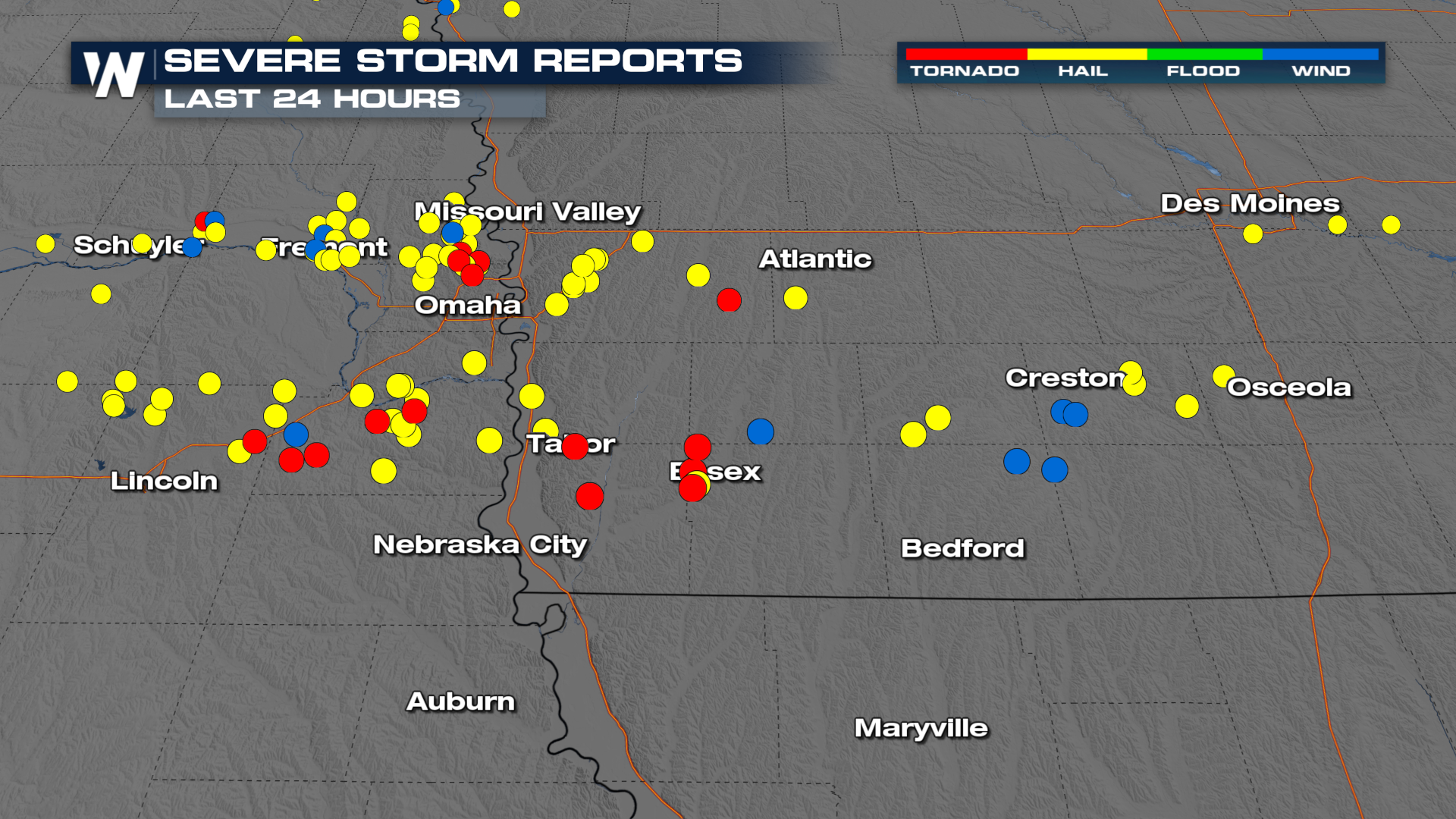 Thankfully, no injuries or deaths have been reported from these storms, though multiple buildings were damaged. The tornado that tracked into Essex, IA has been given a rating of EF-1, though it was an incredibly wide tornado with a maximum width of over 3,000 yards!
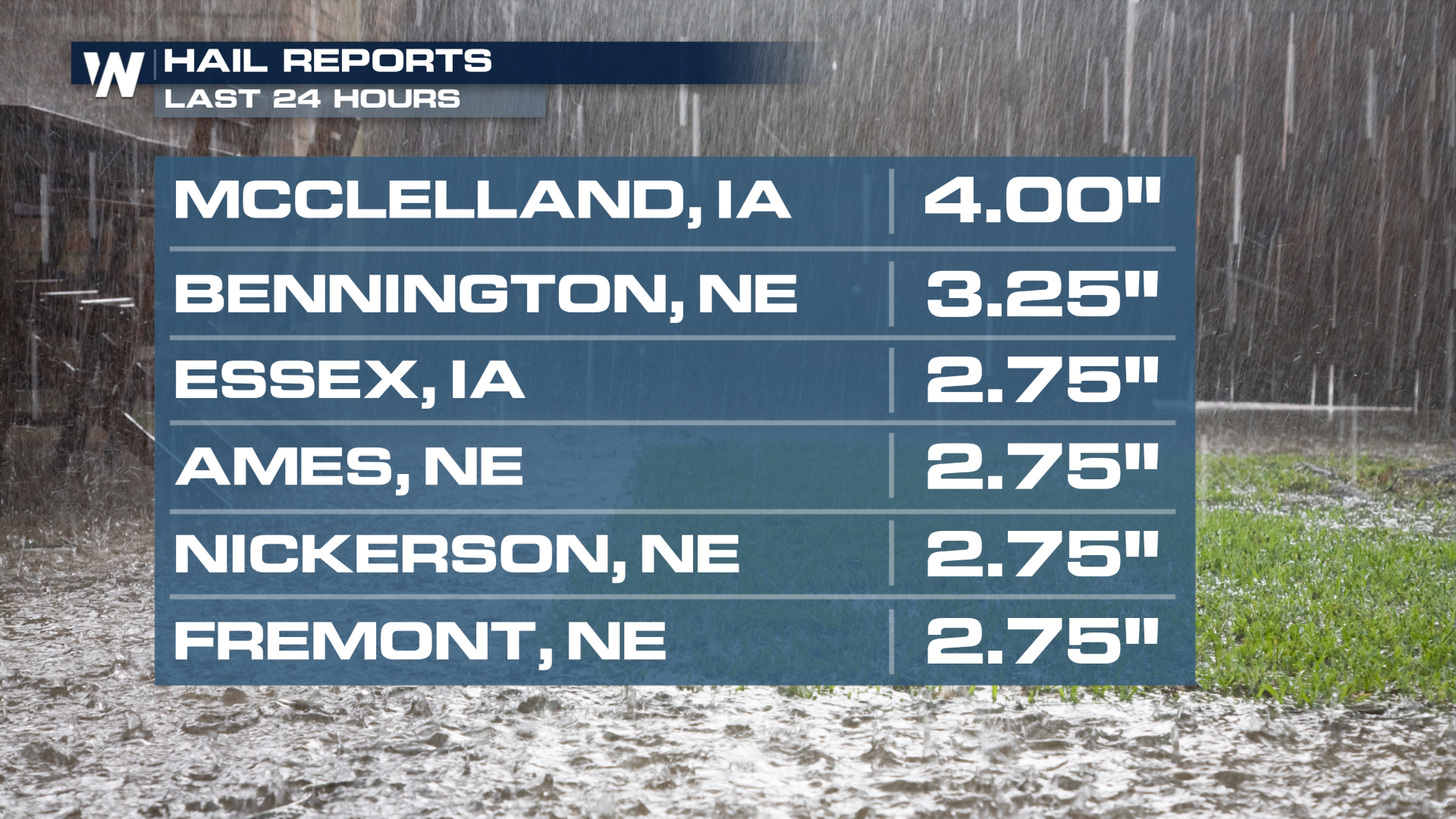 Massive hail was also produced by these powerful cells, topping softball size in Mcclelland, IA!
Additional severe storms are possible through the weekend - click here to stay up to date!
Check out WeatherNationTV for your latest updates on the severe weather.


