Snow in Southern California? Really.

Special Stories
18 Jan 2018 11:38 AM
A powerful storm system moving into the western United States will bring winter weather to parts of the Northwest but also to parts of the Southwest.
In particular after fires, mudslides and floods, Southern California now has winter weather advisories that are already posted for high elevation and mountain areas around Los Angeles and San Diego. These advisories will become active on Friday and carry through into Saturday.
3 to 6 inches of snow is expected across some of the highest mountain locations in the region, especially north facing surfaces. Lighter amounts are expected at lower elevations, as low as 2,5oo feet.
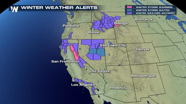
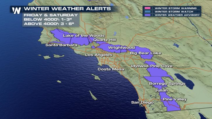 The Los Angeles National Weather Service mentioned that this kind of weather could lead to tough and hazardous travel through high elevation locations. The weather Service also said that the expected weather could lead to road closures as well.
The Los Angeles National Weather Service mentioned that this kind of weather could lead to tough and hazardous travel through high elevation locations. The weather Service also said that the expected weather could lead to road closures as well.
Winter Weather Advisory in effect for snow and blowing snow from Friday 10 AM PST thru 4 PM PST Sat. Snow level lowering to 3500 ft by Fri afternoon. 3-6 inches of snowfall expected above 4500 ft. I-5 Corridor near Grapevine could see hazardous driving conditions. #LArain #cawx pic.twitter.com/F21MCcmyoD
— NWS Los Angeles (@NWSLosAngeles) January 18, 2018
For WeatherNation, I am Meteorologist Marcus Walter.Potential significant travel impacts for I-5 near #Grapevine Fri afternoon-Sat morning due to possible accumulating snow and strong winds. #CAstorm #LArain #LAWeather #cawx pic.twitter.com/tbGChdfQgT
— NWS Los Angeles (@NWSLosAngeles) January 18, 2018
All Weather News
More
Spring Snow on the Horizon in Colorado
Snow is on the way for the mountains of Color
26 Apr 2024 3:00 AM
Weekend Forecast: More Severe Weather
We are looking at the threat of another sever
26 Apr 2024 2:45 AM
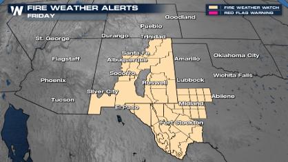
Critical Fire Risk in West Texas, New Mexico
A critical fire risk is in place for west Tex
26 Apr 2024 2:40 AM
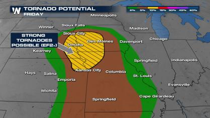
Significant Storm Threat Tonight, Friday
The spring season often means rounds of inten
26 Apr 2024 2:35 AM

National Park Week: Get Out and Explore
National Park Week started Saturday, April 20
25 Apr 2024 9:30 PM

NOAA Debuts "HeatRisk" Tool Nationwide
More people die from heat every year than ALL
25 Apr 2024 9:00 PM

Double Trouble: Cicadas Take to the Skies this Spring
It’s the soundtrack to the summer. Nature’s n
25 Apr 2024 8:45 PM