Help from Above: Satellites Aid Kilauea Disaster Response
Special Stories
22 May 2018 6:53 AM
From NASA
The Kilauea volcano on Hawaii’s Big Island has been erupting this month from new fissures and sent lava flowing over streets and neighborhoods. With an array of sophisticated Earth-observing sensors in orbit and partnerships with space agencies around the globe, satellites have had a lot of assets to offer.
“One of the first things emergency responders wanted to know was where the lava was coming out, where are all the fissures,” said J. Carver Struve, NASA emergency management co-lead at NASA Headquarters in Washington who coordinates the organization and distribution of data and satellite imagery from seven NASA centers.
In total, seven instruments onboard five NASA and partner satellites provided key information on eruption patterns and atmospheric impacts of the Kilauea eruption. These included detection of active fissures, fires, ash and sulfur dioxide plumes, deformation of the ground caused by magma movement, and the height and composition of volcanic plumes. Even astronauts onboard the International Space Station were able to view the eruption, sending digital camera images to the USGS and response community. The European Space Agency and Japan Aerospace Exploration Agency also contributed data to the effort.
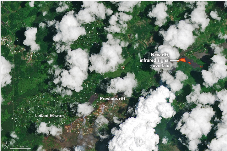 [At 10:41 a.m. local time in Hawaii on May 14, the Operational Land Imager (OLI) on Landsat 8 acquired a natural-color image of the eruption. Information from the shortwave infrared (band 7) has been layered onto the image to show where the satellite detected unusually warm temperatures (red) associated with lava. Recent lava flows appear gray; forested areas are dark green. Homes appear as small white dots. The lava was flowing from fissure 17, one of the most active of the 20 new fissures that have emerged. Credits: NASA Earth Observatory]
Feedback from responders in Hawaii using the data has led to the creation of additional data products tailored to their immediate needs. "We're providing actionable scientific products to teams on the ground to support response activities and fill any gaps they may have in their information as the disaster is evolving," said Struve.
In addition to providing data to support recovery and resilience planning, NASA has a long-standing research effort to understand volcanic processes before, during and after eruptions, insights that can also serve as a window into understanding volcanoes on other planets. The current Kilauea eruption is an opportunity to evaluate the performance of instruments to estimate lava flow rates and volume, crucial parameters in volcanic models.
NASA is contributing to the understanding of the eruption using airborne assets. The G-III research aircraft is flying an all-weather, high-resolution instrument called the Glacier and Ice Surface Topography Interferometer (GLISTIN) that was developed to study small changes in ice sheets. The science team, based at NASA's Jet Propulsion Laboratory in Pasadena, California, previously used GLISTIN to study the surface topography of Kilauea’s East Rift Zone.
[At 10:41 a.m. local time in Hawaii on May 14, the Operational Land Imager (OLI) on Landsat 8 acquired a natural-color image of the eruption. Information from the shortwave infrared (band 7) has been layered onto the image to show where the satellite detected unusually warm temperatures (red) associated with lava. Recent lava flows appear gray; forested areas are dark green. Homes appear as small white dots. The lava was flowing from fissure 17, one of the most active of the 20 new fissures that have emerged. Credits: NASA Earth Observatory]
Feedback from responders in Hawaii using the data has led to the creation of additional data products tailored to their immediate needs. "We're providing actionable scientific products to teams on the ground to support response activities and fill any gaps they may have in their information as the disaster is evolving," said Struve.
In addition to providing data to support recovery and resilience planning, NASA has a long-standing research effort to understand volcanic processes before, during and after eruptions, insights that can also serve as a window into understanding volcanoes on other planets. The current Kilauea eruption is an opportunity to evaluate the performance of instruments to estimate lava flow rates and volume, crucial parameters in volcanic models.
NASA is contributing to the understanding of the eruption using airborne assets. The G-III research aircraft is flying an all-weather, high-resolution instrument called the Glacier and Ice Surface Topography Interferometer (GLISTIN) that was developed to study small changes in ice sheets. The science team, based at NASA's Jet Propulsion Laboratory in Pasadena, California, previously used GLISTIN to study the surface topography of Kilauea’s East Rift Zone.
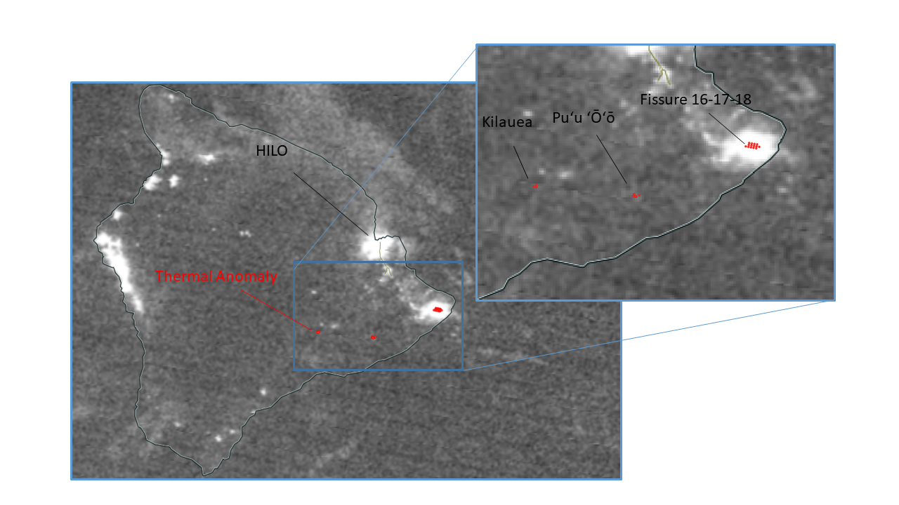 [The VIIRS instrument on the NASA-NOAA Suomi NPP satellite showed this enhanced nighttime image on May 15 superimposed with thermal anomalies (red points). Multiple thermal anomalies associated with bright light emissions are observed near the southeast tip of Hawaii’s Big Island. A zoom over this area shows that those thermal anomalies are consistent with the new observed opening fissures further east from the Leilani area. Thermal anomalies are also observed near the Kilauea and Puʻu ʻŌʻō craters but without significant bright spots. Credits: NASA]
A sequence of repeat flights during the current eruption are using GLISTIN to detect changes in Kilauea's topography associated with the new lava flows, with the goal of measuring the erupted volume as a function of time and ultimately the total volume of the event. Such observations are extremely useful to quantitatively evaluate models for evolution of volcanic processes.
NASA’s Disasters Program supports application science and mobilizes for intensive risk events globally, covering a range of natural hazards – earthquakes, tsunamis, wildfires, floods, landslides, severe weather, winter storms, tropical cyclones, volcanoes – and human-made events such as oil spills and industrial accidents.
[The VIIRS instrument on the NASA-NOAA Suomi NPP satellite showed this enhanced nighttime image on May 15 superimposed with thermal anomalies (red points). Multiple thermal anomalies associated with bright light emissions are observed near the southeast tip of Hawaii’s Big Island. A zoom over this area shows that those thermal anomalies are consistent with the new observed opening fissures further east from the Leilani area. Thermal anomalies are also observed near the Kilauea and Puʻu ʻŌʻō craters but without significant bright spots. Credits: NASA]
A sequence of repeat flights during the current eruption are using GLISTIN to detect changes in Kilauea's topography associated with the new lava flows, with the goal of measuring the erupted volume as a function of time and ultimately the total volume of the event. Such observations are extremely useful to quantitatively evaluate models for evolution of volcanic processes.
NASA’s Disasters Program supports application science and mobilizes for intensive risk events globally, covering a range of natural hazards – earthquakes, tsunamis, wildfires, floods, landslides, severe weather, winter storms, tropical cyclones, volcanoes – and human-made events such as oil spills and industrial accidents.
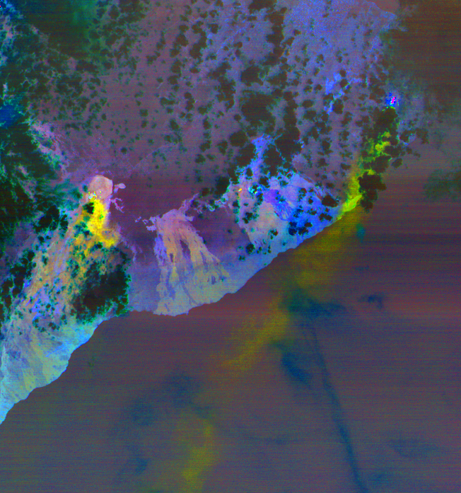 [Massive sulfur dioxide plumes are shown in yellow and green. The image was extracted from data provided by the ASTER instrument on NASA’s Terra spacecraft. Credits: NASA/METI/AIST/Japan Space Systems, U.S./Japan ASTER Science Team]
NASA uses the vantage point of space to understand and explore our home planet, improve lives and safeguard our future. The agency brings together technology, science, and unique global Earth observations to provide societal benefits and strengthen our nation. The Disasters Program data products and images are available at https://maps.disasters.nasa.gov and https://disasters.nasa.gov/kilauea-hawaii-eruption-2018.
Edited for WeatherNation by Meteorologist Mace Michaels
[Massive sulfur dioxide plumes are shown in yellow and green. The image was extracted from data provided by the ASTER instrument on NASA’s Terra spacecraft. Credits: NASA/METI/AIST/Japan Space Systems, U.S./Japan ASTER Science Team]
NASA uses the vantage point of space to understand and explore our home planet, improve lives and safeguard our future. The agency brings together technology, science, and unique global Earth observations to provide societal benefits and strengthen our nation. The Disasters Program data products and images are available at https://maps.disasters.nasa.gov and https://disasters.nasa.gov/kilauea-hawaii-eruption-2018.
Edited for WeatherNation by Meteorologist Mace Michaels
[At 10:41 a.m. local time in Hawaii on May 14, the Operational Land Imager (OLI) on Landsat 8 acquired a natural-color image of the eruption. Information from the shortwave infrared (band 7) has been layered onto the image to show where the satellite detected unusually warm temperatures (red) associated with lava. Recent lava flows appear gray; forested areas are dark green. Homes appear as small white dots. The lava was flowing from fissure 17, one of the most active of the 20 new fissures that have emerged. Credits: NASA Earth Observatory]
Feedback from responders in Hawaii using the data has led to the creation of additional data products tailored to their immediate needs. "We're providing actionable scientific products to teams on the ground to support response activities and fill any gaps they may have in their information as the disaster is evolving," said Struve.
In addition to providing data to support recovery and resilience planning, NASA has a long-standing research effort to understand volcanic processes before, during and after eruptions, insights that can also serve as a window into understanding volcanoes on other planets. The current Kilauea eruption is an opportunity to evaluate the performance of instruments to estimate lava flow rates and volume, crucial parameters in volcanic models.
NASA is contributing to the understanding of the eruption using airborne assets. The G-III research aircraft is flying an all-weather, high-resolution instrument called the Glacier and Ice Surface Topography Interferometer (GLISTIN) that was developed to study small changes in ice sheets. The science team, based at NASA's Jet Propulsion Laboratory in Pasadena, California, previously used GLISTIN to study the surface topography of Kilauea’s East Rift Zone.
[The VIIRS instrument on the NASA-NOAA Suomi NPP satellite showed this enhanced nighttime image on May 15 superimposed with thermal anomalies (red points). Multiple thermal anomalies associated with bright light emissions are observed near the southeast tip of Hawaii’s Big Island. A zoom over this area shows that those thermal anomalies are consistent with the new observed opening fissures further east from the Leilani area. Thermal anomalies are also observed near the Kilauea and Puʻu ʻŌʻō craters but without significant bright spots. Credits: NASA]
A sequence of repeat flights during the current eruption are using GLISTIN to detect changes in Kilauea's topography associated with the new lava flows, with the goal of measuring the erupted volume as a function of time and ultimately the total volume of the event. Such observations are extremely useful to quantitatively evaluate models for evolution of volcanic processes.
NASA’s Disasters Program supports application science and mobilizes for intensive risk events globally, covering a range of natural hazards – earthquakes, tsunamis, wildfires, floods, landslides, severe weather, winter storms, tropical cyclones, volcanoes – and human-made events such as oil spills and industrial accidents.
[Massive sulfur dioxide plumes are shown in yellow and green. The image was extracted from data provided by the ASTER instrument on NASA’s Terra spacecraft. Credits: NASA/METI/AIST/Japan Space Systems, U.S./Japan ASTER Science Team]
NASA uses the vantage point of space to understand and explore our home planet, improve lives and safeguard our future. The agency brings together technology, science, and unique global Earth observations to provide societal benefits and strengthen our nation. The Disasters Program data products and images are available at https://maps.disasters.nasa.gov and https://disasters.nasa.gov/kilauea-hawaii-eruption-2018.
Edited for WeatherNation by Meteorologist Mace MichaelsAll Weather News
More
Major River Flooding Causes Damage; Another Day of Storms in New Mexico
A powerful low pressure system has been movin
25 Oct 2026 2:05 AM

Warmer Than Average: Above-Normal Temperatures Across the Central U.S. This Week
WHAT TO EXPECTA ridge of high pressure linger
25 Oct 2026 1:20 AM

Hurricane Vance Swirling in the Pacific
After becoming a hurricane Friday, Vance quic
25 Oct 2026 1:05 AM

Sunny Day Flooding; King Tides Surge This Week
This week, the ocean is coming to low lying a
25 Oct 2026 1:00 AM


Several Fires Break Out in SoCal Last Week Amid Santa Ana Wind Event
Santa Ana winds helped several fires grow qui
19 Oct 2026 1:25 PM

Another Cold Morning Before Things Warm Back Up
Across portions of the Ohio Valley through th
19 Oct 2026 10:15 AM