Hurricanes Rains Can Be More Intense After Winds Subside
Special Stories
18 Dec 2019 2:00 AM
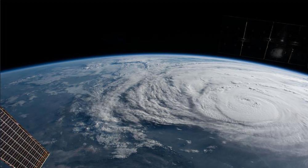
[The International Space Station orbited over Hurricane Harvey and photographed the storm bearing down on the Texas coast. From NASA]
[UCSB] Howling wind drives torrential rain sideways as tall, slender palms bow and tree limbs snap. A hurricane approaches, its gale-force winds wreaking havoc as it nears the coast. Storm surges combine with the downpour, inundating the area with water.
But according to new research out of UC Santa Barbara, the rains that come once the storm has weakened may actually be more intense than when the storm is at its strongest.
“The highest intensities of rainfall occur after the hurricanes have weakened to tropical storms, not when they first make landfall as major hurricanes,” said lead author Danielle Touma, a postdoctoral scholar at the university’s Bren School of Environmental Science & Management. The study appears in the journal Geophysical Research Letters.
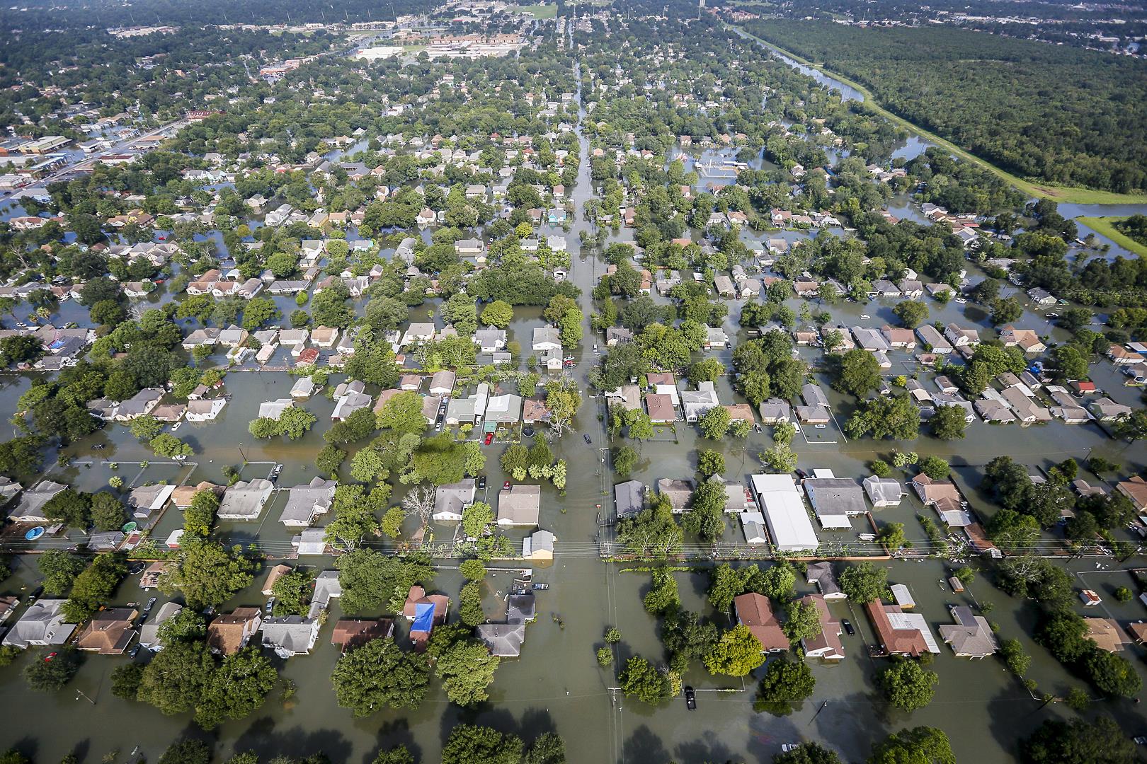 [Flooded neighborhoods in Houston after Hurricane Harvey on August 31, 2017. Air National Guard photo by Staff Sgt. Daniel J. Martinez]
The finding has counterintuitive implications. “If we’re thinking about risks, we know that major hurricanes can drive storm surges, there’s strong winds and so on. But this paper is also saying hurricanes are still dangerous even after they’ve weakened to tropical storms,” said coauthor Samantha Stevenson, an assistant professor at Bren.
Around the time Hurricane Harvey hit Houston in 2017, Touma was developing a new method for studying areas and intensities of rainfall around tropical cyclones — which include hurricanes and tropical storms — based on weather station data. Many previous studies have used satellite and radar data, but these records are limited to the late 20th and early 21st centuries. In contrast, records from weather stations begin in 1900. Using the measurements from the stations, Touma could calculate the extent of land that experienced rain from a given weather system, as well as how much rain fell.
These issues were in sharp focus during the 2017 hurricane season, especially as flooding in Southern Texas racked up roughly $130 billion in damages, according to the National Oceanic and Atmospheric Administration.
[Flooded neighborhoods in Houston after Hurricane Harvey on August 31, 2017. Air National Guard photo by Staff Sgt. Daniel J. Martinez]
The finding has counterintuitive implications. “If we’re thinking about risks, we know that major hurricanes can drive storm surges, there’s strong winds and so on. But this paper is also saying hurricanes are still dangerous even after they’ve weakened to tropical storms,” said coauthor Samantha Stevenson, an assistant professor at Bren.
Around the time Hurricane Harvey hit Houston in 2017, Touma was developing a new method for studying areas and intensities of rainfall around tropical cyclones — which include hurricanes and tropical storms — based on weather station data. Many previous studies have used satellite and radar data, but these records are limited to the late 20th and early 21st centuries. In contrast, records from weather stations begin in 1900. Using the measurements from the stations, Touma could calculate the extent of land that experienced rain from a given weather system, as well as how much rain fell.
These issues were in sharp focus during the 2017 hurricane season, especially as flooding in Southern Texas racked up roughly $130 billion in damages, according to the National Oceanic and Atmospheric Administration.
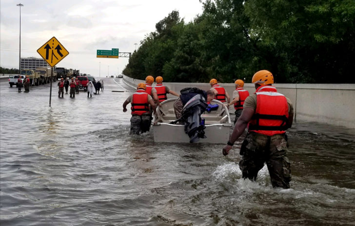 [Texas National Guard arrives in Houston, Texas to aid residents in heavily flooded areas from Hurricane Harvey, Aug. 27, 2017. Credit: 1st Lt. Zachary Wes.]
Analyzing decades of records, Touma discovered that the accompanying rainfall tended to be more severe after a hurricane had abated to the category of a tropical storm. In that sense, the cyclones were more dangerous after they had subsided, in spite of their slower wind speeds.
“You might think hurricanes are most dangerous when they’re strongest, because that’s when the winds are whipping around the fastest,” Stevenson said, “but this paper actually finds that the risk due to extreme rainfall is largest after the hurricane has weakened a bit.”
Tropical cyclones tend to slow down once they hit land because they are cut off from their energy source, the ocean. There’s no longer warm water evaporating below them to drive the convection that fuels the system. As a result, the cyclone becomes disorganized and spins at lower speeds, causing it to spread out. “Now it’s kind of parked in one spot, and it can just dump a lot of rain on a particular location,” Stevenson explained.
[Texas National Guard arrives in Houston, Texas to aid residents in heavily flooded areas from Hurricane Harvey, Aug. 27, 2017. Credit: 1st Lt. Zachary Wes.]
Analyzing decades of records, Touma discovered that the accompanying rainfall tended to be more severe after a hurricane had abated to the category of a tropical storm. In that sense, the cyclones were more dangerous after they had subsided, in spite of their slower wind speeds.
“You might think hurricanes are most dangerous when they’re strongest, because that’s when the winds are whipping around the fastest,” Stevenson said, “but this paper actually finds that the risk due to extreme rainfall is largest after the hurricane has weakened a bit.”
Tropical cyclones tend to slow down once they hit land because they are cut off from their energy source, the ocean. There’s no longer warm water evaporating below them to drive the convection that fuels the system. As a result, the cyclone becomes disorganized and spins at lower speeds, causing it to spread out. “Now it’s kind of parked in one spot, and it can just dump a lot of rain on a particular location,” Stevenson explained.
 [Danielle Touma, Bren School of Environmental Science & Management, UCSB]
Naturally, this effect is most pronounced for cyclones that started as major hurricanes. A smaller cyclone would follow the same pattern — hit land, slow down and spread out — but it wouldn’t contain the sheer volume of water to cause the same degree of damage.
Scientists predict that the intensity of tropical cyclone rainfall will increase as global temperatures rise. In fact, the team has already begun to see this trend in their historical data.
“Since our analysis used longer records than previous studies, we were better able to detect long-term trends,” Stevenson explained. “What this paper adds to the conversation is which types of storms we have to pay more attention to in disaster preparedness plans.”
[Danielle Touma, Bren School of Environmental Science & Management, UCSB]
Naturally, this effect is most pronounced for cyclones that started as major hurricanes. A smaller cyclone would follow the same pattern — hit land, slow down and spread out — but it wouldn’t contain the sheer volume of water to cause the same degree of damage.
Scientists predict that the intensity of tropical cyclone rainfall will increase as global temperatures rise. In fact, the team has already begun to see this trend in their historical data.
“Since our analysis used longer records than previous studies, we were better able to detect long-term trends,” Stevenson explained. “What this paper adds to the conversation is which types of storms we have to pay more attention to in disaster preparedness plans.”
[Flooded neighborhoods in Houston after Hurricane Harvey on August 31, 2017. Air National Guard photo by Staff Sgt. Daniel J. Martinez]
The finding has counterintuitive implications. “If we’re thinking about risks, we know that major hurricanes can drive storm surges, there’s strong winds and so on. But this paper is also saying hurricanes are still dangerous even after they’ve weakened to tropical storms,” said coauthor Samantha Stevenson, an assistant professor at Bren.
Around the time Hurricane Harvey hit Houston in 2017, Touma was developing a new method for studying areas and intensities of rainfall around tropical cyclones — which include hurricanes and tropical storms — based on weather station data. Many previous studies have used satellite and radar data, but these records are limited to the late 20th and early 21st centuries. In contrast, records from weather stations begin in 1900. Using the measurements from the stations, Touma could calculate the extent of land that experienced rain from a given weather system, as well as how much rain fell.
These issues were in sharp focus during the 2017 hurricane season, especially as flooding in Southern Texas racked up roughly $130 billion in damages, according to the National Oceanic and Atmospheric Administration.
[Texas National Guard arrives in Houston, Texas to aid residents in heavily flooded areas from Hurricane Harvey, Aug. 27, 2017. Credit: 1st Lt. Zachary Wes.]
Analyzing decades of records, Touma discovered that the accompanying rainfall tended to be more severe after a hurricane had abated to the category of a tropical storm. In that sense, the cyclones were more dangerous after they had subsided, in spite of their slower wind speeds.
“You might think hurricanes are most dangerous when they’re strongest, because that’s when the winds are whipping around the fastest,” Stevenson said, “but this paper actually finds that the risk due to extreme rainfall is largest after the hurricane has weakened a bit.”
Tropical cyclones tend to slow down once they hit land because they are cut off from their energy source, the ocean. There’s no longer warm water evaporating below them to drive the convection that fuels the system. As a result, the cyclone becomes disorganized and spins at lower speeds, causing it to spread out. “Now it’s kind of parked in one spot, and it can just dump a lot of rain on a particular location,” Stevenson explained.
[Danielle Touma, Bren School of Environmental Science & Management, UCSB]
Naturally, this effect is most pronounced for cyclones that started as major hurricanes. A smaller cyclone would follow the same pattern — hit land, slow down and spread out — but it wouldn’t contain the sheer volume of water to cause the same degree of damage.
Scientists predict that the intensity of tropical cyclone rainfall will increase as global temperatures rise. In fact, the team has already begun to see this trend in their historical data.
“Since our analysis used longer records than previous studies, we were better able to detect long-term trends,” Stevenson explained. “What this paper adds to the conversation is which types of storms we have to pay more attention to in disaster preparedness plans.”
All Weather News
More


More Storms for the East Sunday and Monday
A low-pressure system crashing through the Mi
2 Aug 2026 2:20 AM

After Reaching Category 5, Genevieve Weakens in the Pacific
PacificGenevieve formed on last Friday south
2 Aug 2026 1:30 AM

Flooding, Severe Storms Target the Midwest Again
After an active week of storms across the nor
1 Aug 2026 1:40 AM

Flooding Risk Increases as Heavy Rain Targets the Tri-State Area
Tuesday, heavy rainfall moved across the Nort
30 Jul 2026 12:25 AM

Severe Weather: Energy From the Midwest Now in the Southeast
UPPER MIDWEST - Through Monday, dangerous tor
29 Jul 2026 10:30 PM