July Recap - Third Hottest on Record for the U.S.
Special Stories
16 Aug 2022 2:00 AM
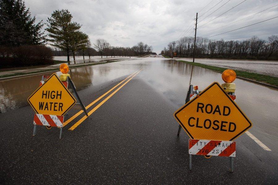
[Flooding in Marissa, IL July 26th causing road closures (Marissa Fire Department)]
[From NOAA and NOAA NCEI] July 2022 will go down in the history books as the third-hottest July on record for the U.S., according to scientists from NOAA’s National Centers for Environmental Information.
From drought to deluge, the nation saw remarkable extremes last month. Drought conditions intensified or expanded across parts of the U.S., while others were hit by historic rainfall that led to catastrophic flooding.
Below are more takeaways from NOAA’s latest monthly U.S. climate report:
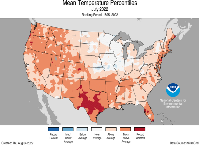 The average temperature across the contiguous U.S. last month was 76.4 degrees F (2.8 degrees above average), making July 2022 the third-hottest July in the 128-year climate record. Only July 1936 (first) and July 2012 (second) were hotter.
Texas felt the brunt of the heat, reporting its hottest July, May-July and April-July on record. Near-record warmth also covered locations from the Pacific Northwest to the south-central U.S., and across parts of the Northeast. Oregon had its fourth-hottest July on record, with Colorado, Florida, Louisiana, New Mexico, Oklahoma and Rhode Island sweltering through their top-five warmest Julys on record.
The average temperature across the contiguous U.S. last month was 76.4 degrees F (2.8 degrees above average), making July 2022 the third-hottest July in the 128-year climate record. Only July 1936 (first) and July 2012 (second) were hotter.
Texas felt the brunt of the heat, reporting its hottest July, May-July and April-July on record. Near-record warmth also covered locations from the Pacific Northwest to the south-central U.S., and across parts of the Northeast. Oregon had its fourth-hottest July on record, with Colorado, Florida, Louisiana, New Mexico, Oklahoma and Rhode Island sweltering through their top-five warmest Julys on record.
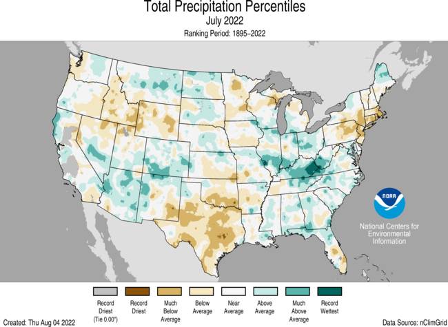 The average July precipitation was 2.74 inches (0.04 of an inch below average), ranking in the middle third of the historical record. Kentucky saw its fourth-wettest July due to record rainfall during the last week of the month. Precipitation was above average in pockets across the West Coast, Southwest, Northern Rockies and Plains, Great Lakes and from parts of the Midwest to southern Appalachians. Elsewhere, Rhode Island saw its second-driest July while Texas had its fifth driest. Precipitation was below average across portions of the Northwest, southern Plains, Upper Midwest and Northeast.
 The year-to-date (YTD) average temperature for the contiguous U.S. was 52.7 degrees F (1.4 degrees above the average), ranking in the warmest-third YTD on record. Temperatures were above average from Oregon to the Gulf Coast and northward to New England. California and Florida each ranked sixth warmest on record for the YTD. Temperatures were below average across parts of the Upper Midwest.
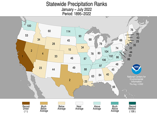
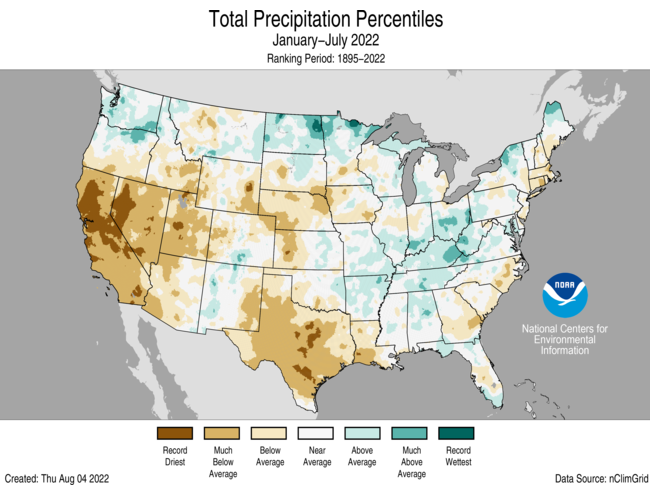
The first seven months of 2022 saw an average precipitation of 16.58 inches (1.51 inches below average), which ranked in the driest third of the record. Precipitation was below average across much of the West, central Plains and Deep South for this YTD period. California had its driest January-July on record, while Nevada and Texas saw their second driest and Utah saw its fourth driest. Precipitation was above average across parts of the Northwest, northern Plains, Great Lakes and portions of the Mid-Mississippi, Ohio and Tennessee valleys.
The year-to-date (YTD) average temperature for the contiguous U.S. was 52.7 degrees F (1.4 degrees above the average), ranking in the warmest-third YTD on record. Temperatures were above average from Oregon to the Gulf Coast and northward to New England. California and Florida each ranked sixth warmest on record for the YTD. Temperatures were below average across parts of the Upper Midwest.
The first seven months of 2022 saw an average precipitation of 16.58 inches (1.51 inches below average), which ranked in the driest third of the record. Precipitation was below average across much of the West, central Plains and Deep South for this YTD period. California had its driest January-July on record, while Nevada and Texas saw their second driest and Utah saw its fourth driest. Precipitation was above average across parts of the Northwest, northern Plains, Great Lakes and portions of the Mid-Mississippi, Ohio and Tennessee valleys.
 Excessive Heat: Several heat waves, with daytime temperatures over 100°F, occurred across much of the U.S. during July, contributing to record energy demand and heat-related illnesses.
Drought increased in coverage and intensity: According to the August 2 U.S. Drought Monitor report, 51.4% of the contiguous U.S. was in drought, up about 3.7% from the end of June. Drought conditions expanded or intensified across portions of the Northeast, with flash drought rapidly expanding in the southern and central Plains, Ozarks and the mid-Mississippi Valley. Drought decreased or was eliminated across portions of the Southeast, Midwest, Southwest, northern Rockies as well as Alaska and Puerto Rico.
Edited for WeatherNation by Mace Michaels
Excessive Heat: Several heat waves, with daytime temperatures over 100°F, occurred across much of the U.S. during July, contributing to record energy demand and heat-related illnesses.
Drought increased in coverage and intensity: According to the August 2 U.S. Drought Monitor report, 51.4% of the contiguous U.S. was in drought, up about 3.7% from the end of June. Drought conditions expanded or intensified across portions of the Northeast, with flash drought rapidly expanding in the southern and central Plains, Ozarks and the mid-Mississippi Valley. Drought decreased or was eliminated across portions of the Southeast, Midwest, Southwest, northern Rockies as well as Alaska and Puerto Rico.
Edited for WeatherNation by Mace Michaels
July 2022
The average temperature across the contiguous U.S. last month was 76.4 degrees F (2.8 degrees above average), making July 2022 the third-hottest July in the 128-year climate record. Only July 1936 (first) and July 2012 (second) were hotter.
Texas felt the brunt of the heat, reporting its hottest July, May-July and April-July on record. Near-record warmth also covered locations from the Pacific Northwest to the south-central U.S., and across parts of the Northeast. Oregon had its fourth-hottest July on record, with Colorado, Florida, Louisiana, New Mexico, Oklahoma and Rhode Island sweltering through their top-five warmest Julys on record.
The average July precipitation was 2.74 inches (0.04 of an inch below average), ranking in the middle third of the historical record. Kentucky saw its fourth-wettest July due to record rainfall during the last week of the month. Precipitation was above average in pockets across the West Coast, Southwest, Northern Rockies and Plains, Great Lakes and from parts of the Midwest to southern Appalachians. Elsewhere, Rhode Island saw its second-driest July while Texas had its fifth driest. Precipitation was below average across portions of the Northwest, southern Plains, Upper Midwest and Northeast.
Year to date (January through July 2022)
The year-to-date (YTD) average temperature for the contiguous U.S. was 52.7 degrees F (1.4 degrees above the average), ranking in the warmest-third YTD on record. Temperatures were above average from Oregon to the Gulf Coast and northward to New England. California and Florida each ranked sixth warmest on record for the YTD. Temperatures were below average across parts of the Upper Midwest.
The first seven months of 2022 saw an average precipitation of 16.58 inches (1.51 inches below average), which ranked in the driest third of the record. Precipitation was below average across much of the West, central Plains and Deep South for this YTD period. California had its driest January-July on record, while Nevada and Texas saw their second driest and Utah saw its fourth driest. Precipitation was above average across parts of the Northwest, northern Plains, Great Lakes and portions of the Mid-Mississippi, Ohio and Tennessee valleys.
Other notable climate events
Catastrophic flooding ravaged communities: On July 26, several locations in and around St. Louis, Missouri, received more rainfall than any other day on record. A stalled weather system combined with tropical moisture resulted in precipitation totals that rivaled daily records set by the remnants of the Galveston Hurricane of 1915. St. Louis’ Lambert International Airport reported 8.64 inches and St. Peters, Missouri, measured 12.34 inches of rain from this event. The extreme rainfall caused flash flooding, resulting in at least one fatality as well as extensive damage to homes and businesses. Flash flooding from the same system impacted portions of eastern Kentucky on the early morning of July 28. Heavy rain, enhanced by the hilly terrain, accumulated rapidly — trapping many residents in their homes. Four-to-eight inches of rain were widespread across eastern Kentucky and the Kentucky River crested to an all-time high in both Whitesburg and Jackson, Kentucky. The flooding resulted in at least 37 fatalities.
Excessive Heat: Several heat waves, with daytime temperatures over 100°F, occurred across much of the U.S. during July, contributing to record energy demand and heat-related illnesses.
Drought increased in coverage and intensity: According to the August 2 U.S. Drought Monitor report, 51.4% of the contiguous U.S. was in drought, up about 3.7% from the end of June. Drought conditions expanded or intensified across portions of the Northeast, with flash drought rapidly expanding in the southern and central Plains, Ozarks and the mid-Mississippi Valley. Drought decreased or was eliminated across portions of the Southeast, Midwest, Southwest, northern Rockies as well as Alaska and Puerto Rico.
Edited for WeatherNation by Mace MichaelsAll Weather News
More
Fire Weather Continues This Weekend
Conditions have been really dry out west. We'
26 Jul 2026 10:40 AM

Heat Wave Grips Central, Western U.S.
Are you over the summer heat yet? The heat al
26 Jul 2026 10:35 AM

Tropics: Fausto Heads to Hawaii; Genevieve Will Become a Major Hurricane
Atlantic BasinBertha has dissipated after mov
26 Jul 2026 10:35 AM

Severe Storms Target the Midwest This Weekend
Extreme heat will be a big story this week ac
26 Jul 2026 10:30 AM

Southeast Flood Risk Lingers Near Stalled Front
A stalled boundary over the Southeast will ke
25 Jul 2026 10:55 AM

Another Round of Storms Targets the Northeast
Tuesday brought severe weather again across p
23 Jul 2026 1:15 AM

Another Round of Severe Weather for the Upper Midwest and Great Lakes
The upper-level low train continues to keep t
21 Jul 2026 1:45 AM