New Rating System Charts a Path to Improved Tornado Forecasts
Special Stories
19 Mar 2021 2:00 AM
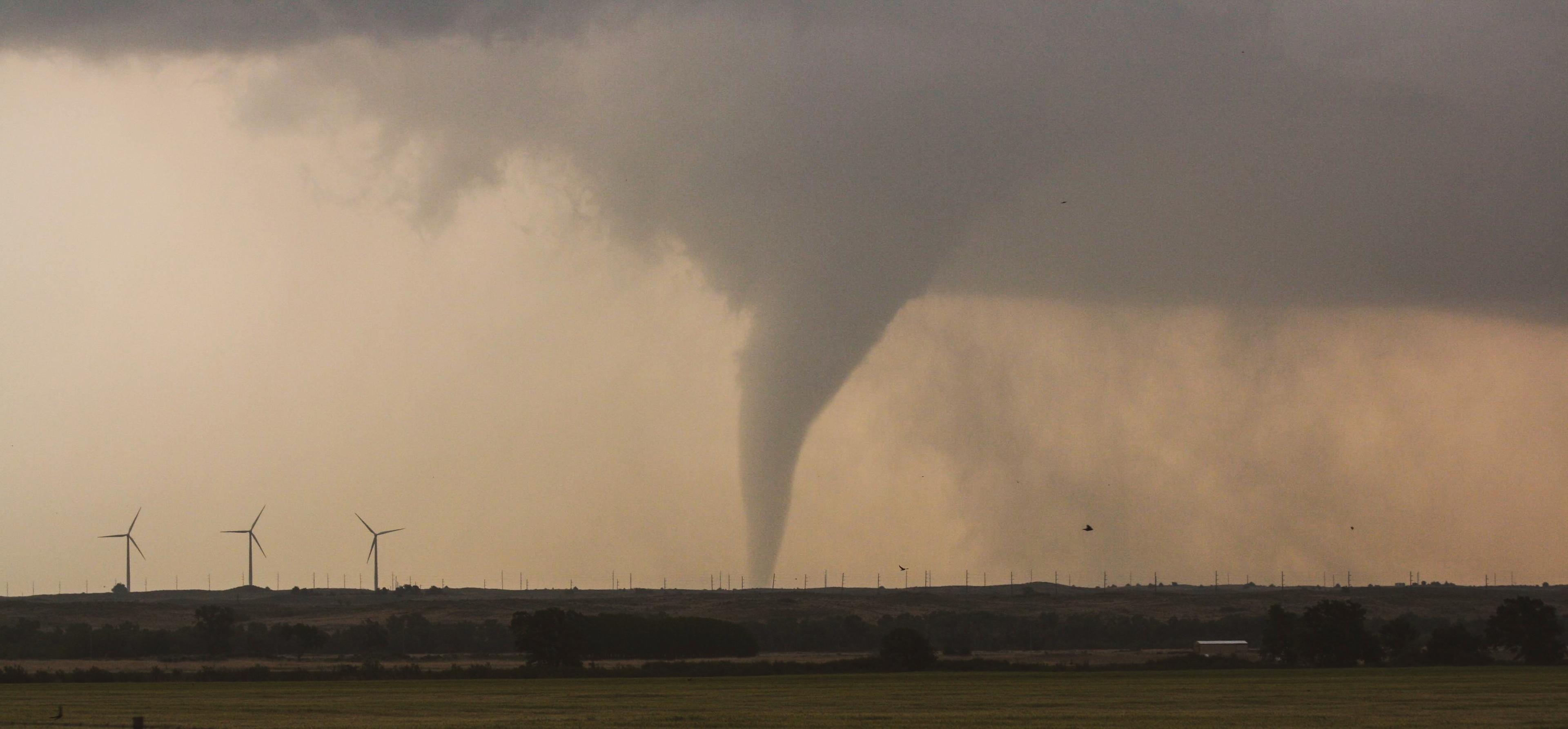
[This stovepipe tornado was captured near Fort Supply, Oklahoma on May 23, 2008, during the VORTEX 2 Risk Reduction Research Project. Credit: Sean Waugh, NOAA/NSSL]
[From University of Washington by Hannah Hickey] The United States experiences more tornadoes than any other country, with a season that peaks in spring or summer depending on the region. Tornadoes are often deadly, especially in places where buildings can’t withstand high winds.
Accurate advanced warnings can save lives. A study from the University of Washington and the National Oceanic and Atmospheric Administration describes a new way to rate and possibly improve tornado warnings. It finds that nighttime twisters, summer tornadoes and smaller events remain the biggest challenges for the forecasting community.
“This new method lets us measure how forecast skill is improving, decreasing or staying the same in different situations,” said Alex Anderson-Frey, a UW assistant professor of atmospheric sciences. “The tornado forecasting community needs to know what we’re doing best at, and where we can focus training and research in the future.”
She is lead author of the paper published online in December in the Bulletin of the American Meteorological Society.
 Though the southern and central U.S. see the most tornadoes, every state can experience twisters. Scientific understanding of tornadoes is biased toward populated places, Anderson-Frey said, where people are more likely to observe and report the events.
“As population density increases in different areas, including outside the U.S., I think we’re getting more of an idea of the range of environments in which tornadoes can actually form,” Anderson-Frey said.
The paper develops a new method to rate the skill of a tornado warning based on the difficulty of the environment. It then evaluates thousands of tornadoes and associated warnings over the continental United States between 2003 and 2017.
The NOAA-funded study finds that nighttime tornadoes have a lower probability of detection and a higher false-alarm rate than the environmental conditions would suggest. Summertime tornadoes, occurring in June, July or August, also are more likely to evade warning.
Though the southern and central U.S. see the most tornadoes, every state can experience twisters. Scientific understanding of tornadoes is biased toward populated places, Anderson-Frey said, where people are more likely to observe and report the events.
“As population density increases in different areas, including outside the U.S., I think we’re getting more of an idea of the range of environments in which tornadoes can actually form,” Anderson-Frey said.
The paper develops a new method to rate the skill of a tornado warning based on the difficulty of the environment. It then evaluates thousands of tornadoes and associated warnings over the continental United States between 2003 and 2017.
The NOAA-funded study finds that nighttime tornadoes have a lower probability of detection and a higher false-alarm rate than the environmental conditions would suggest. Summertime tornadoes, occurring in June, July or August, also are more likely to evade warning.
 The nighttime events may be harder to forecast because the absence of daytime warming makes the conditions less favorable, and because there were fewer eyewitness reports, Anderson-Frey said. Summer events may be more difficult because summer has more relatively weak tornadoes that occur in marginal environments, meaning on the edge of conditions that produce a tornado.
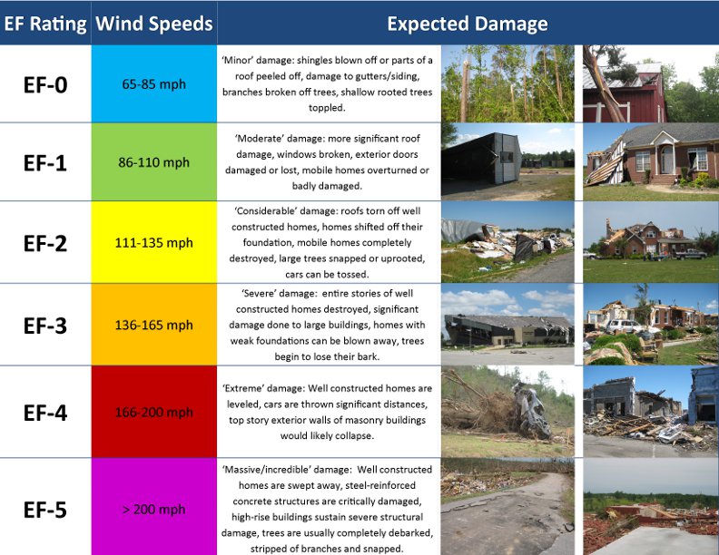
Larger events — those rated 2 or above on the enhanced Fujita scale — actually generated better warnings than expected for the conditions. The results can inform how research, training or observational technology could improve future tornado warnings.
“The forecasting community is not just looking at the big, photogenic situations that will crop up in the Great Plains. We’re looking at tornadoes in regions where vulnerability is high, including in regions that don’t normally get tornadoes, where by definition the vulnerability is high,” Anderson-Frey said.
“There’s a real effort in the forecasting research community to bring in the human element — being able to identify where we can do the most good.”
The nighttime events may be harder to forecast because the absence of daytime warming makes the conditions less favorable, and because there were fewer eyewitness reports, Anderson-Frey said. Summer events may be more difficult because summer has more relatively weak tornadoes that occur in marginal environments, meaning on the edge of conditions that produce a tornado.
Larger events — those rated 2 or above on the enhanced Fujita scale — actually generated better warnings than expected for the conditions. The results can inform how research, training or observational technology could improve future tornado warnings.
“The forecasting community is not just looking at the big, photogenic situations that will crop up in the Great Plains. We’re looking at tornadoes in regions where vulnerability is high, including in regions that don’t normally get tornadoes, where by definition the vulnerability is high,” Anderson-Frey said.
“There’s a real effort in the forecasting research community to bring in the human element — being able to identify where we can do the most good.”
 “There’s a real effort in the forecasting research community to bring in the human element — being able to identify where we can do the most good.”
Although tornado forecasts and warnings are improving overall, so are some types of risk. Populations are growing and moving into new, remote environments. Mobile or manufactured homes without anchored foundations are less able to withstand high winds.
“What really excites me about this work is the opportunity to look at performance by how difficult the warning situation was,” said co-author Harold Brooks at NOAA’s National Severe Storm Laboratory in Norman, Oklahoma. “We have the chance to measure improvement through the years taking into account that some situations and years may be harder or easier forecasts.”
“There’s a real effort in the forecasting research community to bring in the human element — being able to identify where we can do the most good.”
Although tornado forecasts and warnings are improving overall, so are some types of risk. Populations are growing and moving into new, remote environments. Mobile or manufactured homes without anchored foundations are less able to withstand high winds.
“What really excites me about this work is the opportunity to look at performance by how difficult the warning situation was,” said co-author Harold Brooks at NOAA’s National Severe Storm Laboratory in Norman, Oklahoma. “We have the chance to measure improvement through the years taking into account that some situations and years may be harder or easier forecasts.”
Though the southern and central U.S. see the most tornadoes, every state can experience twisters. Scientific understanding of tornadoes is biased toward populated places, Anderson-Frey said, where people are more likely to observe and report the events.
“As population density increases in different areas, including outside the U.S., I think we’re getting more of an idea of the range of environments in which tornadoes can actually form,” Anderson-Frey said.
The paper develops a new method to rate the skill of a tornado warning based on the difficulty of the environment. It then evaluates thousands of tornadoes and associated warnings over the continental United States between 2003 and 2017.
The NOAA-funded study finds that nighttime tornadoes have a lower probability of detection and a higher false-alarm rate than the environmental conditions would suggest. Summertime tornadoes, occurring in June, July or August, also are more likely to evade warning.
The nighttime events may be harder to forecast because the absence of daytime warming makes the conditions less favorable, and because there were fewer eyewitness reports, Anderson-Frey said. Summer events may be more difficult because summer has more relatively weak tornadoes that occur in marginal environments, meaning on the edge of conditions that produce a tornado.
Larger events — those rated 2 or above on the enhanced Fujita scale — actually generated better warnings than expected for the conditions. The results can inform how research, training or observational technology could improve future tornado warnings.
“The forecasting community is not just looking at the big, photogenic situations that will crop up in the Great Plains. We’re looking at tornadoes in regions where vulnerability is high, including in regions that don’t normally get tornadoes, where by definition the vulnerability is high,” Anderson-Frey said.
“There’s a real effort in the forecasting research community to bring in the human element — being able to identify where we can do the most good.”
“There’s a real effort in the forecasting research community to bring in the human element — being able to identify where we can do the most good.”
Although tornado forecasts and warnings are improving overall, so are some types of risk. Populations are growing and moving into new, remote environments. Mobile or manufactured homes without anchored foundations are less able to withstand high winds.
“What really excites me about this work is the opportunity to look at performance by how difficult the warning situation was,” said co-author Harold Brooks at NOAA’s National Severe Storm Laboratory in Norman, Oklahoma. “We have the chance to measure improvement through the years taking into account that some situations and years may be harder or easier forecasts.”All Weather News
More


More Storms for the East Sunday and Monday
A low-pressure system crashing through the Mi
2 Aug 2026 2:20 AM

After Reaching Category 5, Genevieve Weakens in the Pacific
PacificGenevieve formed on last Friday south
2 Aug 2026 1:30 AM

Flooding, Severe Storms Target the Midwest Again
After an active week of storms across the nor
1 Aug 2026 1:40 AM

Flooding Risk Increases as Heavy Rain Targets the Tri-State Area
Tuesday, heavy rainfall moved across the Nort
30 Jul 2026 12:25 AM

Severe Weather: Energy From the Midwest Now in the Southeast
UPPER MIDWEST - Through Monday, dangerous tor
29 Jul 2026 10:30 PM