Thanksgiving Holiday Weekend Travel Forecast
Top Stories
22 Nov 2018 8:29 AM
It's hard to believe it's that time of year already - the holidays are upon us! As it always seems to be with holiday travels, there will be a few weather bumps in the road. Here's a look at the travel forecasts through the weekend. For more travel information and useful web links, be sure to scroll to the end of this article.
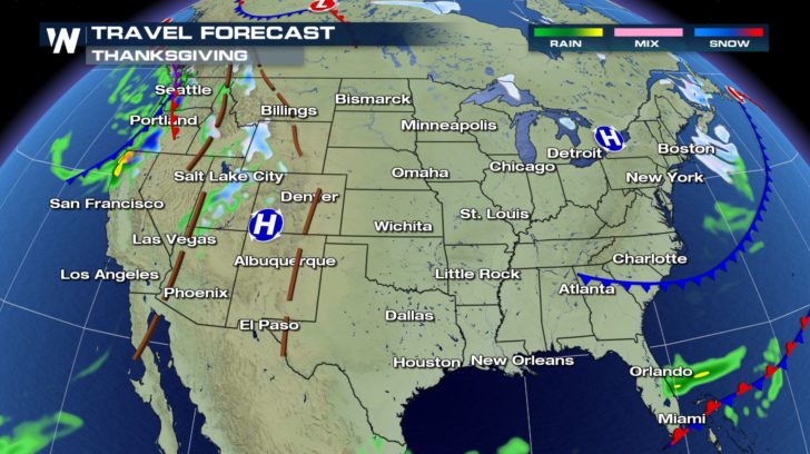
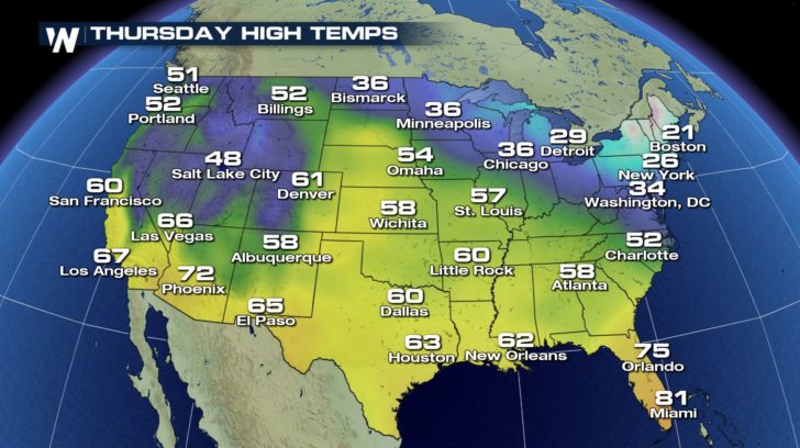
THURSDAY, NOVEMBER 22: THANKSGIVING
More windy, wet, and wintry weather is in the forecast for the West. Rainfall will wind down in the western Gulf of Mexico with some rain still possible in Florida. Near record cold temperatures and a few snow showers will keep things wintry in the Northeast.
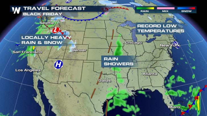
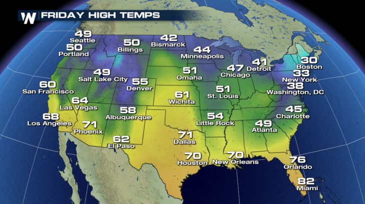
 FRIDAY, NOVEMBER 23: BLACK FRIDAY
While California and the Northwest remain soaked, scattered rain showers will enter the forecast for the Mississippi River Valley. Chilly temperatures will be a concern for shoppers, especially in New England.
FRIDAY, NOVEMBER 23: BLACK FRIDAY
While California and the Northwest remain soaked, scattered rain showers will enter the forecast for the Mississippi River Valley. Chilly temperatures will be a concern for shoppers, especially in New England.
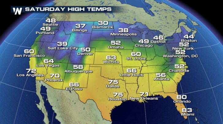
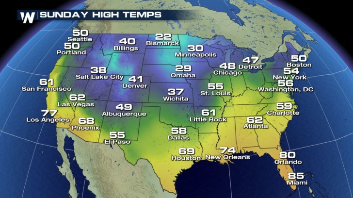
 THE WEEKEND, NOVEMBER 24 - 25
Temperatures will be relatively mild ahead of the next coast-to-coast storm system that will bring wind, rain, and snow from the Rocky Mountains to the Midwest.
THE WEEKEND, NOVEMBER 24 - 25
Temperatures will be relatively mild ahead of the next coast-to-coast storm system that will bring wind, rain, and snow from the Rocky Mountains to the Midwest.
 Here at WeatherNation, we've got you covered with the forecast! But if you're looking for more travel-related information, click on these helpful web links.
AIR TRAVEL
FlightAware Airport Delays
FlightAware Misery Map
John F. Kennedy International Airport in New York City
LaGuardia International Airport in New York City
Hartsfield - Jackson Atlanta International Airport in Georgia
O'Hare International Airport in Chicago
Dallas - Fort Worth International Airport in Texas
Denver International Airport in Colorado
Los Angeles International Airport in California
Seattle - Tacoma International Airport in Washington
TRAIN TRAVEL
Amtrak
ROAD TRAVEL
U.S. Department of Transportation (links to traffic information for each state)
BOAT TRAVEL
New York Waterways
Washington State Ferries
WeatherNation wishes you and your loved ones a happy Thanksgiving and a safe holiday season.
Here at WeatherNation, we've got you covered with the forecast! But if you're looking for more travel-related information, click on these helpful web links.
AIR TRAVEL
FlightAware Airport Delays
FlightAware Misery Map
John F. Kennedy International Airport in New York City
LaGuardia International Airport in New York City
Hartsfield - Jackson Atlanta International Airport in Georgia
O'Hare International Airport in Chicago
Dallas - Fort Worth International Airport in Texas
Denver International Airport in Colorado
Los Angeles International Airport in California
Seattle - Tacoma International Airport in Washington
TRAIN TRAVEL
Amtrak
ROAD TRAVEL
U.S. Department of Transportation (links to traffic information for each state)
BOAT TRAVEL
New York Waterways
Washington State Ferries
WeatherNation wishes you and your loved ones a happy Thanksgiving and a safe holiday season.
FRIDAY, NOVEMBER 23: BLACK FRIDAY
While California and the Northwest remain soaked, scattered rain showers will enter the forecast for the Mississippi River Valley. Chilly temperatures will be a concern for shoppers, especially in New England.
THE WEEKEND, NOVEMBER 24 - 25
Temperatures will be relatively mild ahead of the next coast-to-coast storm system that will bring wind, rain, and snow from the Rocky Mountains to the Midwest.
Here at WeatherNation, we've got you covered with the forecast! But if you're looking for more travel-related information, click on these helpful web links.
AIR TRAVEL
FlightAware Airport Delays
FlightAware Misery Map
John F. Kennedy International Airport in New York City
LaGuardia International Airport in New York City
Hartsfield - Jackson Atlanta International Airport in Georgia
O'Hare International Airport in Chicago
Dallas - Fort Worth International Airport in Texas
Denver International Airport in Colorado
Los Angeles International Airport in California
Seattle - Tacoma International Airport in Washington
TRAIN TRAVEL
Amtrak
ROAD TRAVEL
U.S. Department of Transportation (links to traffic information for each state)
BOAT TRAVEL
New York Waterways
Washington State Ferries
WeatherNation wishes you and your loved ones a happy Thanksgiving and a safe holiday season.All Weather News
More
Fronts Continue To Spark Severe Weather Across the Plains
A cold front that brought record lows to the
18 Jul 2025 10:40 PM

Extreme Heat Impacts for the East Coast & South
Extreme heat continues to impact several area
18 Jul 2025 10:05 PM

Flooding Threat Remains Elevated in the East
A cold front pushing through the Eastern Seab
18 Jul 2025 9:10 PM

EF-2 Firenado from the Deer Creek Fire in Utah
A fire tornado was spotted near La Sal, Utah
18 Jul 2025 7:30 AM

Tropical System Brings Flood Risk to the Central Gulf
Time has run out for notable tropical develop
18 Jul 2025 3:05 AM

Heavy Rain, Flooding Threat Returns to Florida
Keep the rain boots handy in Florida - heavy
13 Jul 2025 12:50 PM

Severe Storm Risk Pushes into the Great Lakes, Ohio Valley
Friday was another busy day with severe weath
12 Jul 2025 8:00 PM