A "Frontal Triple Point" Often Leads To Severe Storms
Special Stories
20 Dec 2018 11:45 AM
As we begin this article, the first question many of you may have is, "what in the world is a Frontal Triple Point?" Quite simply, it's where three fronts come together at a common point.
We have a very good example of this weather phenomenon happening today, December 20th, 2018. Let's examine the surface map below.
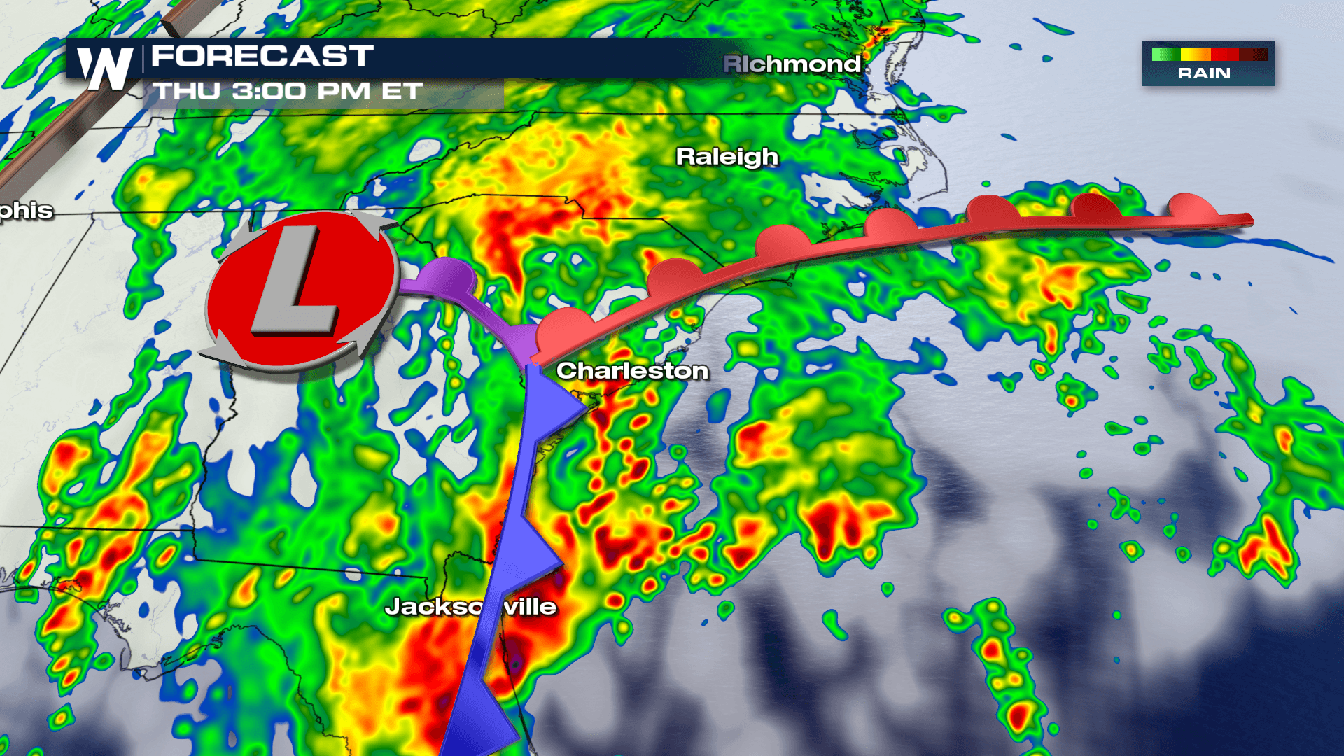
The big red "L" is the center of the storm system. It stands for Low Pressure.
The red colored line is the warm front. It's generally found to the right of the low pressure center. It is the warm sector of the storm.
The blue colored line is the cold front. It is generally found to the south of the warm front. It wraps colder air around the low pressure center.
The cold front usually moves faster than the warm front. Where the cold front lifts the warm front, a new front forms, called an occluded front. The occluded front is denoted by a purple line.
The Triple Point is where the warm front, cold front, and occluded front all intersect.
In the graphic below, you can see where the triple point is forecasted to be at 3pm eastern time. It will be just to the west of Charleston.
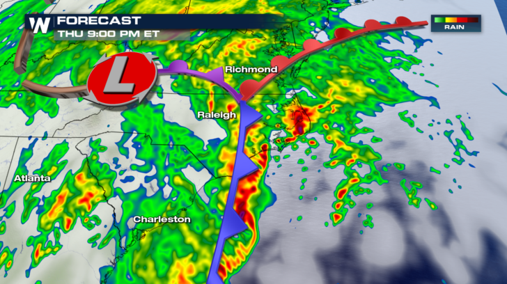
 By 9pm tonight, the triple point will be in-between Richmond and Raleigh.
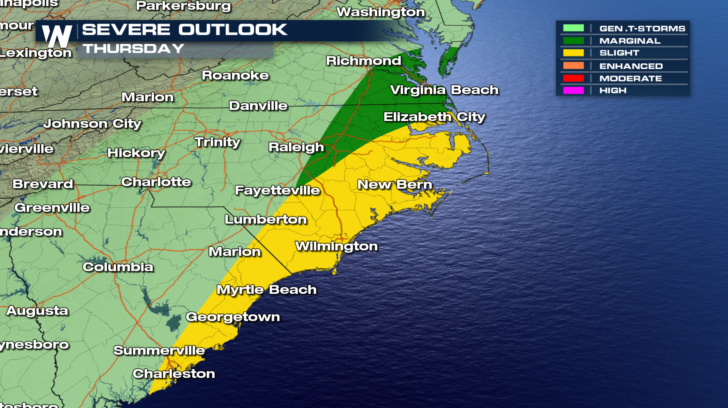
 The triple point is important, because it's an area of great atmospheric energy, and instability. If there's enough available moisture being drawn into the warm sector, then very heavy rain can result along the triple point and along the fronts. There is also a tremendous amount of wind shear near the triple point. Severe weather will often fire up in the vicinity of the warm front and triple point, and out ahead of the cold front. These are the areas where wind shear is very pronounced.
Check out the severe weather outlook below. As the triple point moves northward up the east coast, the severe risk extends from the triple point, eastward. It is no coincidence that the Storm Prediction Center in Norman Oklahoma placed the risk areas where they did. Tornadoes and damaging straight line winds will be possible today and tonight in this risk area.
The triple point is important, because it's an area of great atmospheric energy, and instability. If there's enough available moisture being drawn into the warm sector, then very heavy rain can result along the triple point and along the fronts. There is also a tremendous amount of wind shear near the triple point. Severe weather will often fire up in the vicinity of the warm front and triple point, and out ahead of the cold front. These are the areas where wind shear is very pronounced.
Check out the severe weather outlook below. As the triple point moves northward up the east coast, the severe risk extends from the triple point, eastward. It is no coincidence that the Storm Prediction Center in Norman Oklahoma placed the risk areas where they did. Tornadoes and damaging straight line winds will be possible today and tonight in this risk area.
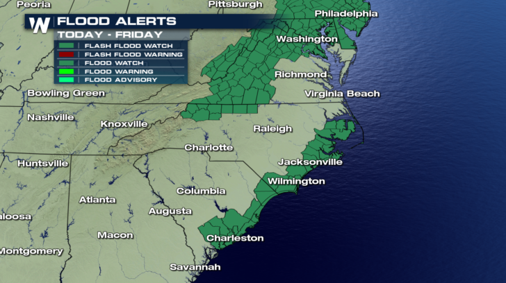
 And likewise, the risk for the heaviest rains, potentially causing flash flooding, extended along the North and South Carolina coastal areas. These areas are to the east of the triple point. Heavy rain is also possible in western Virginia near the occluded front.
 So in summary, if we know where the triple point will be at a given time, we can predict with some degree of certainty where heaviest rains and severe weather will be located.
For WeatherNation: Meteorologist Matt Monroe
So in summary, if we know where the triple point will be at a given time, we can predict with some degree of certainty where heaviest rains and severe weather will be located.
For WeatherNation: Meteorologist Matt Monroe
By 9pm tonight, the triple point will be in-between Richmond and Raleigh.
The triple point is important, because it's an area of great atmospheric energy, and instability. If there's enough available moisture being drawn into the warm sector, then very heavy rain can result along the triple point and along the fronts. There is also a tremendous amount of wind shear near the triple point. Severe weather will often fire up in the vicinity of the warm front and triple point, and out ahead of the cold front. These are the areas where wind shear is very pronounced.
Check out the severe weather outlook below. As the triple point moves northward up the east coast, the severe risk extends from the triple point, eastward. It is no coincidence that the Storm Prediction Center in Norman Oklahoma placed the risk areas where they did. Tornadoes and damaging straight line winds will be possible today and tonight in this risk area.
And likewise, the risk for the heaviest rains, potentially causing flash flooding, extended along the North and South Carolina coastal areas. These areas are to the east of the triple point. Heavy rain is also possible in western Virginia near the occluded front.
So in summary, if we know where the triple point will be at a given time, we can predict with some degree of certainty where heaviest rains and severe weather will be located.
For WeatherNation: Meteorologist Matt Monroe
All Weather News
More
Fronts Continue To Spark Severe Weather Across the Plains
A cold front that brought record lows to the
18 Jul 2025 10:40 PM

Extreme Heat Impacts for the East Coast & South
Extreme heat continues to impact several area
18 Jul 2025 10:05 PM

Flooding Threat Remains Elevated in the East
A cold front pushing through the Eastern Seab
18 Jul 2025 9:10 PM

EF-2 Firenado from the Deer Creek Fire in Utah
A fire tornado was spotted near La Sal, Utah
18 Jul 2025 7:30 AM

Tropical System Brings Flood Risk to the Central Gulf
Time has run out for notable tropical develop
18 Jul 2025 3:05 AM

Heavy Rain, Flooding Threat Returns to Florida
Keep the rain boots handy in Florida - heavy
13 Jul 2025 12:50 PM

Severe Storm Risk Pushes into the Great Lakes, Ohio Valley
Friday was another busy day with severe weath
12 Jul 2025 8:00 PM