A Machine-Learning Assist to Predicting Hurricane Intensity
Special Stories
17 Dec 2020 2:43 AM
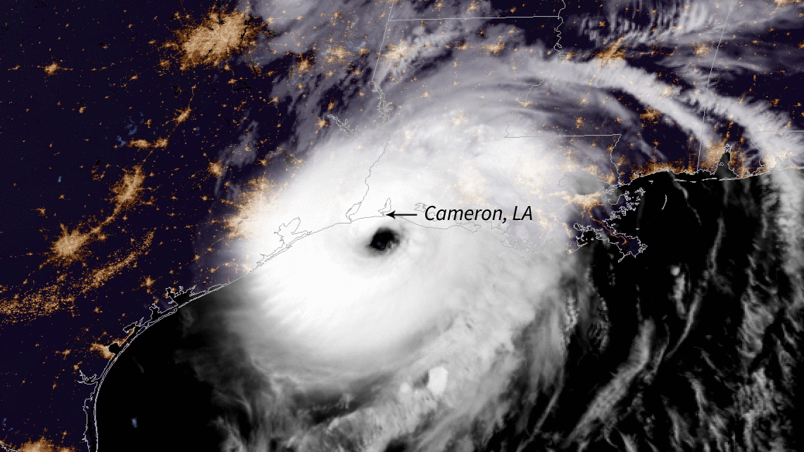
[Shortly before coming ashore in Louisiana, Hurricane Laura - pictured making landfall on Aug. 27 - underwent a process called rapid intensification, with winds that jumped 35 mph (56 kph) or more within 24 hours. Image Credit: NOAA]
[Written by NASA] In October 2015, Hurricane Patricia in the Northeast Pacific Ocean blew up from a Category 1 storm into a Category 5 monster within 24 hours, its winds leaping from 86 mph (138 kph) to 207 mph (333 kph). Patricia wasn't the first or the last hurricane to suddenly strengthen in such a short time - but it was a spectacular demonstration of a phenomenon that has plagued meteorological forecasts for decades.
Accurately predicting whether a hurricane will undergo rapid intensification - where wind speeds increase by 35 mph (56 kph) or more within 24 hours - is incredibly difficult. But researchers led by scientists at NASA's Jet Propulsion Laboratory in Southern California have used machine learning to develop an experimental computer model that promises to greatly improve the accuracy of detecting rapid-intensification events.
"It's an important forecast to get right because of the potential for harm to people and property," said Hui Su, an atmospheric scientist at JPL. She and her colleagues, including a researcher at the National Oceanic and Atmospheric Administration's National Hurricane Center, described their forecast model in a paper published on Aug. 25 in the journal Geophysical Research Letters.
https://www.youtube.com/watch?v=xZ0Q-1u40lA&feature=emb_logo
 For hurricanes whose winds increased by at least 35 mph (56 kph) within 24 hours, the researchers' model had a 60% higher probability of detecting the rapid-intensification event compared to the current operational forecast model. But for those hurricanes with winds that jumped by at least 40 mph (64 kph) within 24 hours, the new model outperformed the operational one at detecting these events by 200%.
Su and her colleagues, including collaborators at the National Hurricane Center, are testing their model on storms during the current hurricane season to gauge its performance. In the future, they plan to sift through satellite data to find additional hurricane characteristics that could improve their machine learning model. Predictors such as whether it's raining harder in one part of a hurricane versus another could give scientists a better look at how the storm's intensity might change over time.
For hurricanes whose winds increased by at least 35 mph (56 kph) within 24 hours, the researchers' model had a 60% higher probability of detecting the rapid-intensification event compared to the current operational forecast model. But for those hurricanes with winds that jumped by at least 40 mph (64 kph) within 24 hours, the new model outperformed the operational one at detecting these events by 200%.
Su and her colleagues, including collaborators at the National Hurricane Center, are testing their model on storms during the current hurricane season to gauge its performance. In the future, they plan to sift through satellite data to find additional hurricane characteristics that could improve their machine learning model. Predictors such as whether it's raining harder in one part of a hurricane versus another could give scientists a better look at how the storm's intensity might change over time.
Eyeing the Inner Workings
There are two parts to a hurricane forecast: its track and its intensity. Scientists and forecasters have gotten very good at predicting where a hurricane will make landfall. But forecasting its strength still gives them trouble because it depends on the surrounding environment as well as what's happening inside these storms. Properties such as how hard it's raining or how quickly the air is moving vertically are challenging to measure inside a hurricane. It's also difficult to determine which internal characteristics result in rapid intensification of these storms. But after sifting through years of satellite data, Su and her colleagues found that a good indicator of how a hurricane's strength will change over the next 24 hours is the rainfall rate inside the storm's inner core - the area within a 62-mile (100-kilometer) radius of the eyewall, or the dense wall of thunderstorms surrounding the eye. The harder it's raining inside a hurricane, the more likely the storm is to intensify. The team gathered this rainfall data from the Tropical Rainfall Measuring Mission, a joint satellite project between NASA and the Japanese Aerospace Exploration Agency that operated from 1997 to 2015. https://www.youtube.com/watch?v=Xo2pBJc_71M&feature=emb_logo In addition, the researchers found that changes in storm intensity depended on the ice water content of clouds within a hurricane - measurements they gathered from NASA's CloudSatobservations. The temperature of the air flowing away from the eye at the top of hurricanes, known as outflow temperature, also factored into intensity changes. Su and her colleagues obtained outflow temperature measurements from NASA's Microwave Limb Sounder (MLS) on the Aura satellite as well as from other datasets.More Power to Learn
The team added the rainfall rate, ice water content, and outflow-temperature predictors to the ones the National Hurricane Center already uses in its operational model to come up with their own predictions via machine learning. There are so many variables inside a hurricane, and they interact in such complex ways, that many current computer models have trouble accurately depicting the inner workings of these storms. Machine learning, however, is better able to analyze these complex internal dynamics and identify which properties could drive a sudden jump in hurricane intensity. The researchers used the computational algorithm capabilities of the IBM Watson Studio to develop their machine learning model. Then they trained their model on storms from 1998 to 2008 and tested it using a different set of storms, from 2009 to 2014. Su and her colleagues also compared the performance of their model with the National Hurricane Center's operational forecast model for the same storms from 2009 to 2014.
For hurricanes whose winds increased by at least 35 mph (56 kph) within 24 hours, the researchers' model had a 60% higher probability of detecting the rapid-intensification event compared to the current operational forecast model. But for those hurricanes with winds that jumped by at least 40 mph (64 kph) within 24 hours, the new model outperformed the operational one at detecting these events by 200%.
Su and her colleagues, including collaborators at the National Hurricane Center, are testing their model on storms during the current hurricane season to gauge its performance. In the future, they plan to sift through satellite data to find additional hurricane characteristics that could improve their machine learning model. Predictors such as whether it's raining harder in one part of a hurricane versus another could give scientists a better look at how the storm's intensity might change over time.All Weather News
More
Repeated Rain Raises the Flood Threat Down South
A slow-moving frontal boundary that brought n
21 May 2026 1:50 AM

Rockies Brace for Snow, Severe Storms as Cold Front Moves In
ROCKIES - Through Thursday, an upper-level lo
21 May 2026 1:50 AM

CALIFORNIA: Wildfires Prompt Evacuations
SIMI VALLEY, CA - On Monday, May 18th in Vent
21 May 2026 1:40 AM


One More Day of Blistering Temperatures
A big warmup is taking hold across the easter
20 May 2026 4:10 PM

Severe Storms Leave Trail of Destruction on the Plains
SUNDAYA potent setup, fueled by record hot te
19 May 2026 4:15 PM

Spring: Frost Alerts Post Winter Alerts in High Country
ROCKIES - The precipitation will continue to
19 May 2026 2:55 AM