A Mile High Amount of Heat for Denver
Special Stories
30 Aug 2018 3:38 PM
On the thirteenth step of the Colorado State Capitol, a small message reads 'One mile above sea level.' It's a popular spot for people visiting Denver to snap a few pictures. This year, the Mile High City has been feeling a "mile high" amount of heat.
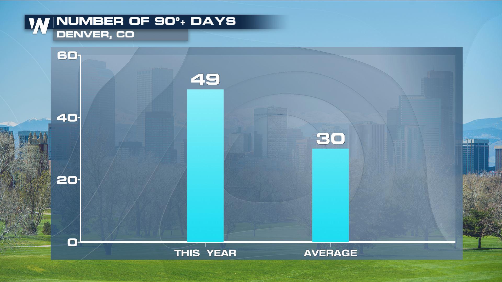
 On average, the Denver area reaches 90 degrees - or hotter - 30 times each year. It breaks down to this:
June: 6 days
July: 13 days
August: 9 days
September: 2 days
(^^Average # of 90°+ days for Denver^^) Source: https://w2.weather.gov/climate/index.php?wfo=bou
However this year breaks down as follows:
May: 4 days
June: 16 days
July: 19 days
August: 10 days
May and June were clearly the warmest-to-average, when comparing the amount of 90°+ days. The total through Thursday, August 30 is 49 days. It may sound high to the average of 30, but it's still quite apart from the record. The most number of 90°+ days was 73 in 2012, then 61 days in 2000. The 10th-most was 52 days in 1978. There is a decent chance at getting into the top ten.
On average, the Denver area reaches 90 degrees - or hotter - 30 times each year. It breaks down to this:
June: 6 days
July: 13 days
August: 9 days
September: 2 days
(^^Average # of 90°+ days for Denver^^) Source: https://w2.weather.gov/climate/index.php?wfo=bou
However this year breaks down as follows:
May: 4 days
June: 16 days
July: 19 days
August: 10 days
May and June were clearly the warmest-to-average, when comparing the amount of 90°+ days. The total through Thursday, August 30 is 49 days. It may sound high to the average of 30, but it's still quite apart from the record. The most number of 90°+ days was 73 in 2012, then 61 days in 2000. The 10th-most was 52 days in 1978. There is a decent chance at getting into the top ten.
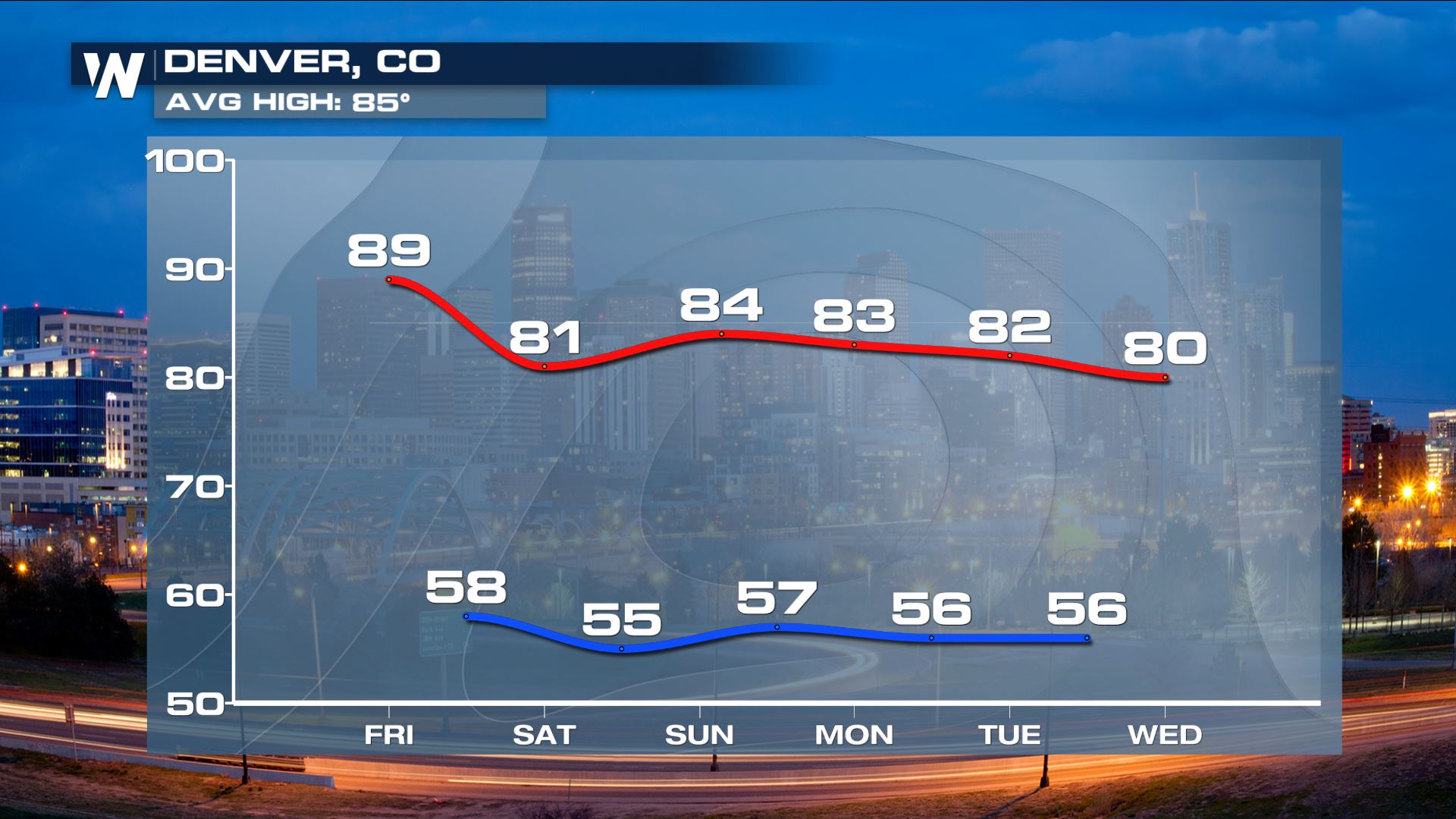 High temperature forecast in red, low temperature forecast in blue from Friday, August 31 to Wednesday, September 5
The 50th 90°+ day could come on Friday, August 31 with a forecast high within a degree of that mark. Afterward, it cools through the first week of September. The *average* high temperature this time of the year is between 83 and 85 degrees. September yields an average of (2) 90°+ days for Denver. The longer-range forecast through mid-September is currently advertising at or above average temperatures for the Mile High City.
High temperature forecast in red, low temperature forecast in blue from Friday, August 31 to Wednesday, September 5
The 50th 90°+ day could come on Friday, August 31 with a forecast high within a degree of that mark. Afterward, it cools through the first week of September. The *average* high temperature this time of the year is between 83 and 85 degrees. September yields an average of (2) 90°+ days for Denver. The longer-range forecast through mid-September is currently advertising at or above average temperatures for the Mile High City.
 Temperature outlook between Wednesday, September 5 and Sunday, September 9 where oranges/reds show likely warmer-than-average conditions and blue shows likely cooler-than-average conditions.
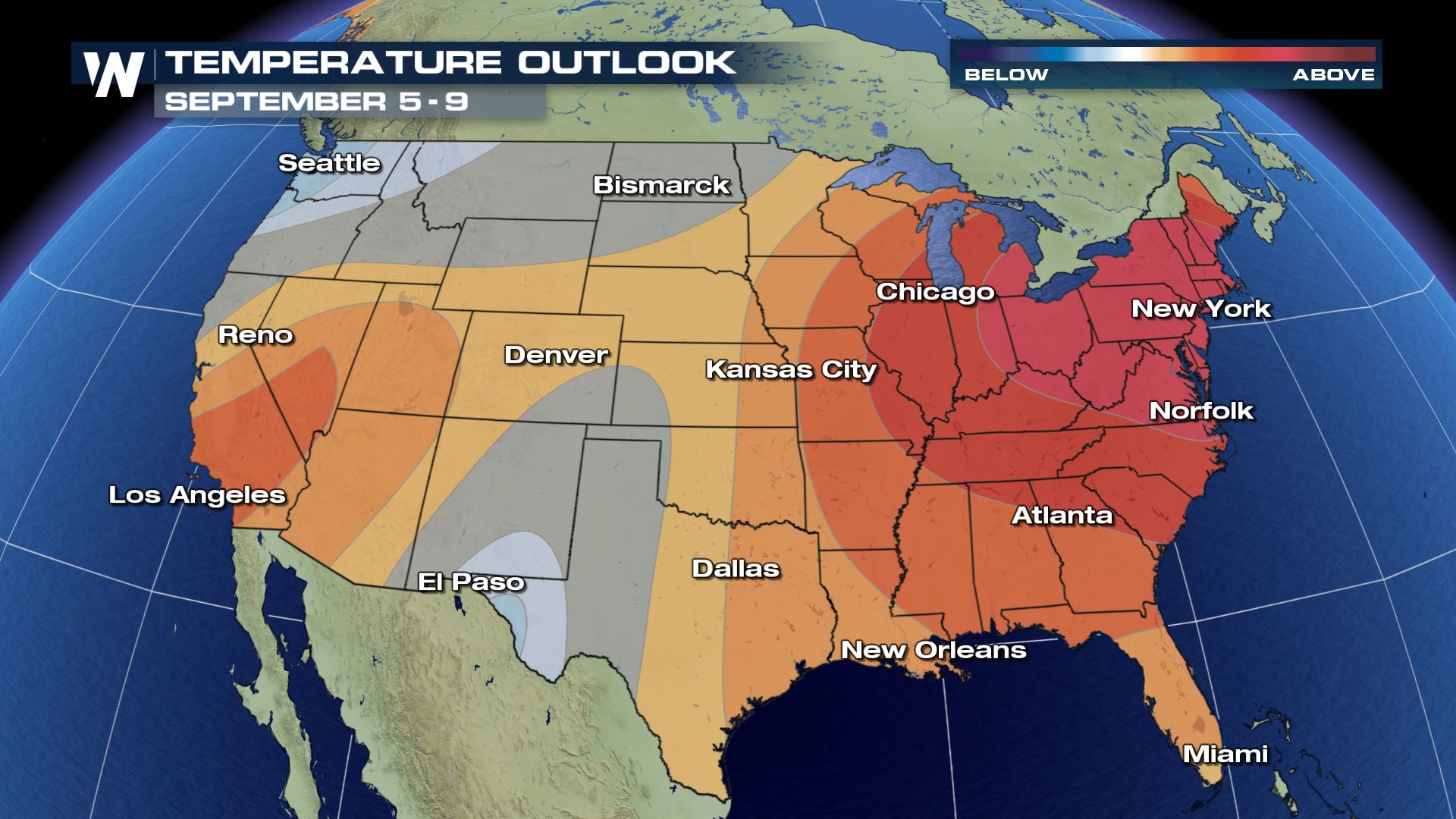
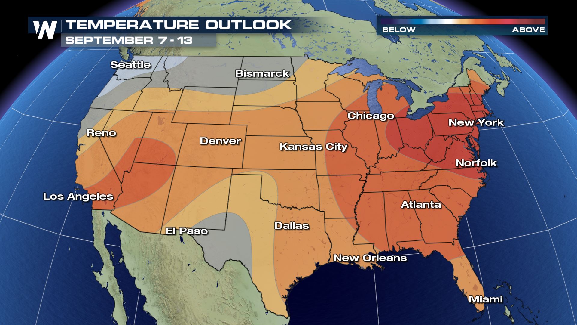 Temperature outlook between Friday, September 7 and Thursday, September 13 where oranges/reds show likely warmer-than-average conditions and blue shows likely cooler-than-average conditions.
The Mile High City is known for being at an elevation of 5,280 feet above sea level. However, it is also known for how quickly the weather can change from near 80 degrees one afternoon to snow the next day. While the heat appears to hang in there, winter will be here before you know it.
For WeatherNation, Meteorologist Steve Glazier
Temperature outlook between Friday, September 7 and Thursday, September 13 where oranges/reds show likely warmer-than-average conditions and blue shows likely cooler-than-average conditions.
The Mile High City is known for being at an elevation of 5,280 feet above sea level. However, it is also known for how quickly the weather can change from near 80 degrees one afternoon to snow the next day. While the heat appears to hang in there, winter will be here before you know it.
For WeatherNation, Meteorologist Steve Glazier
On average, the Denver area reaches 90 degrees - or hotter - 30 times each year. It breaks down to this:
June: 6 days
July: 13 days
August: 9 days
September: 2 days
(^^Average # of 90°+ days for Denver^^) Source: https://w2.weather.gov/climate/index.php?wfo=bou
However this year breaks down as follows:
May: 4 days
June: 16 days
July: 19 days
August: 10 days
May and June were clearly the warmest-to-average, when comparing the amount of 90°+ days. The total through Thursday, August 30 is 49 days. It may sound high to the average of 30, but it's still quite apart from the record. The most number of 90°+ days was 73 in 2012, then 61 days in 2000. The 10th-most was 52 days in 1978. There is a decent chance at getting into the top ten.
High temperature forecast in red, low temperature forecast in blue from Friday, August 31 to Wednesday, September 5
The 50th 90°+ day could come on Friday, August 31 with a forecast high within a degree of that mark. Afterward, it cools through the first week of September. The *average* high temperature this time of the year is between 83 and 85 degrees. September yields an average of (2) 90°+ days for Denver. The longer-range forecast through mid-September is currently advertising at or above average temperatures for the Mile High City.
Temperature outlook between Wednesday, September 5 and Sunday, September 9 where oranges/reds show likely warmer-than-average conditions and blue shows likely cooler-than-average conditions.
Temperature outlook between Friday, September 7 and Thursday, September 13 where oranges/reds show likely warmer-than-average conditions and blue shows likely cooler-than-average conditions.
The Mile High City is known for being at an elevation of 5,280 feet above sea level. However, it is also known for how quickly the weather can change from near 80 degrees one afternoon to snow the next day. While the heat appears to hang in there, winter will be here before you know it.
For WeatherNation, Meteorologist Steve GlazierAll Weather News
More

Flooding Risk Increases as Heavy Rain Targets the Tri-State Area
TRI-STATE AREA - Along with the threat of sev
29 Jul 2026 2:00 AM

Tropics: Fausto Heads towards Hawaii; Genevieve a Major Hurricane
PacificTropical Storm Fausto continues to tra
29 Jul 2026 1:35 AM


Southeast Flood Risk Lingers Near Stalled Front
A stalled boundary over the Southeast will ke
25 Jul 2026 10:55 AM

Another Round of Storms Targets the Northeast
Tuesday brought severe weather again across p
23 Jul 2026 1:15 AM