After 148 Days, Mississippi River Falls Below Major Flood Stage

Special Stories
25 Jul 2019 4:27 PM
The Mississippi River at Baton Rouge, LA had been in major flood stage for 148 days...until Wednesday. On July 24th, 2019 the river level at Baton Rouge dropped below the 40 foot level. Above 40 feet is major flood stage. Below 40 feet is moderate flood stage, until 38 feet (and below) which is minor flood stage. Any level below 35 feet is under the flood stage mark.
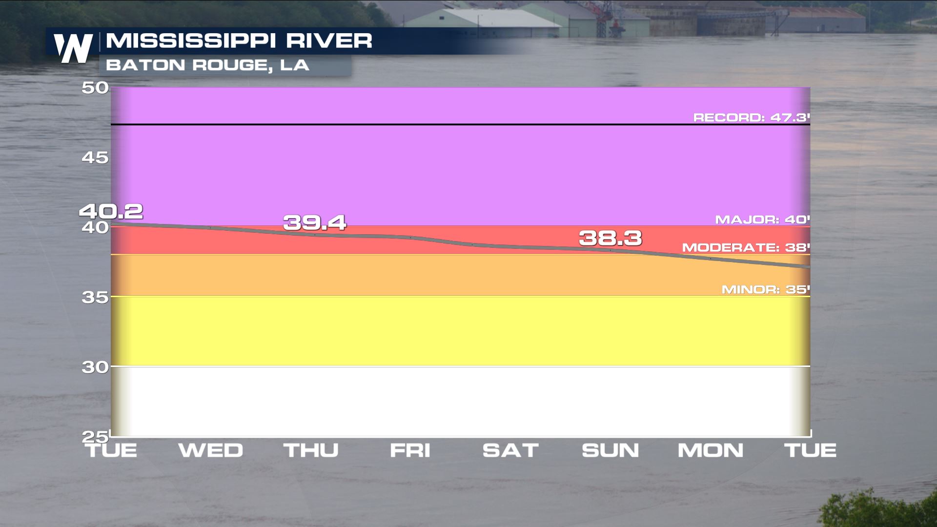 The reason this is impressive is that it shatters the previous record for prolonged flooding of the Mississippi River at Baton Rouge. As of Thursday, July 25th the river at Baton Rouge had been in flood stage for a consecutive 201 days! The previous-longest flood stretch was 135 straight days back in 1927, according to the National Weather Service office in New Orleans.
We would love to impress you with all of the statistics about this flooding event, but we don't want to steal the show. NWS New Orleans provided an in-depth Twitter thread on the subject. We'd like to thank them for the information and show you their tweets:
https://twitter.com/NWSNewOrleans/status/1154072274888286208
https://twitter.com/NWSNewOrleans/status/1154072286967795713
https://twitter.com/NWSNewOrleans/status/1154072298653175808
https://twitter.com/NWSNewOrleans/status/1154072313102512137
https://twitter.com/NWSNewOrleans/status/1154072328822775808
https://twitter.com/NWSNewOrleans/status/1154072342739468289
Twitter threat courtesy NWS New Orleans on Twitter
For WeatherNation, Meteorologist Steve Glazier
The reason this is impressive is that it shatters the previous record for prolonged flooding of the Mississippi River at Baton Rouge. As of Thursday, July 25th the river at Baton Rouge had been in flood stage for a consecutive 201 days! The previous-longest flood stretch was 135 straight days back in 1927, according to the National Weather Service office in New Orleans.
We would love to impress you with all of the statistics about this flooding event, but we don't want to steal the show. NWS New Orleans provided an in-depth Twitter thread on the subject. We'd like to thank them for the information and show you their tweets:
https://twitter.com/NWSNewOrleans/status/1154072274888286208
https://twitter.com/NWSNewOrleans/status/1154072286967795713
https://twitter.com/NWSNewOrleans/status/1154072298653175808
https://twitter.com/NWSNewOrleans/status/1154072313102512137
https://twitter.com/NWSNewOrleans/status/1154072328822775808
https://twitter.com/NWSNewOrleans/status/1154072342739468289
Twitter threat courtesy NWS New Orleans on Twitter
For WeatherNation, Meteorologist Steve GlazierAll Weather News
More
Fronts Continue To Spark Severe Weather Across the Plains
A cold front that brought record lows to the
18 Jul 2025 10:40 PM

Extreme Heat Impacts for the East Coast & South
Extreme heat continues to impact several area
18 Jul 2025 10:05 PM

Flooding Threat Remains Elevated in the East
A cold front pushing through the Eastern Seab
18 Jul 2025 9:10 PM

EF-2 Firenado from the Deer Creek Fire in Utah
A fire tornado was spotted near La Sal, Utah
18 Jul 2025 7:30 AM

Tropical System Brings Flood Risk to the Central Gulf
Time has run out for notable tropical develop
18 Jul 2025 3:05 AM

Heavy Rain, Flooding Threat Returns to Florida
Keep the rain boots handy in Florida - heavy
13 Jul 2025 12:50 PM

Severe Storm Risk Pushes into the Great Lakes, Ohio Valley
Friday was another busy day with severe weath
12 Jul 2025 8:00 PM