An Active Atlantic Could Lead to Heavy Rain for the South
Special Stories
2 Sep 2018 11:28 AM
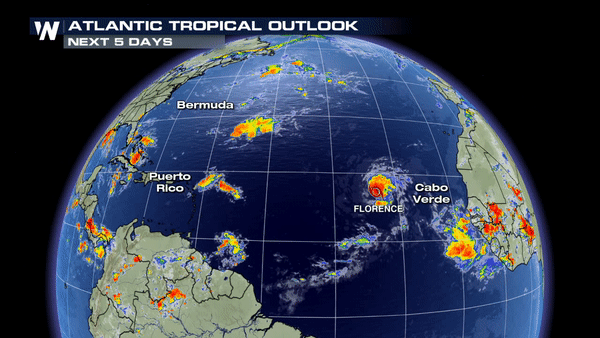
It has been a quiet season, so far, for the Atlantic, but we are starting to see some more activity!
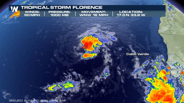 Tropical Storm Florence is just west of Cabo Verde and continues to move WNW at 18 mph. Currently, sustained winds are around 50 mph.
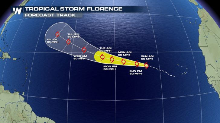 As Florence moves WNW, it is not looking to affect the Caribbean, but could come close to the east coast of the United States. We will definitely keep a close eye on the storm as we near the end of the week.
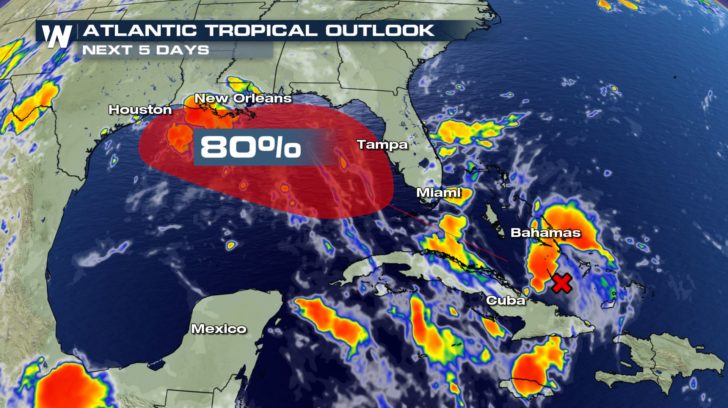 Another area of interest is just off the coast of Cuba. We're watching an area of low pressure that will be moving northwest into the Gulf of Mexico. It has about an 80 percent chance of forming into our next named Atlantic storm. Even if it does not strengthen into a named storm, it is still looking to bring heavy rain to the South and Southeast.
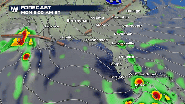 Rain started up early this morning for southern Florida and for the coast of Louisiana and Texas. These same areas will need to be watched over the next few days as the low pressure system moves closer. Rain is looking to be constant, and thunderstorms that form, due to the low pressure system, could produce heavy rainfall.
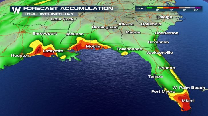 In the next three days, south Florida, the coast of Mississippi, Louisiana, and Texas could experience an abundant amount of rain. These areas could receive anywhere from 1 to 5 inches of rain. Make sure to stay safe! If you see any flooding or ponding on the roads, remember to turn around, don't drown.
For WeatherNation -Meteorologist Shelly Lindblade
In the next three days, south Florida, the coast of Mississippi, Louisiana, and Texas could experience an abundant amount of rain. These areas could receive anywhere from 1 to 5 inches of rain. Make sure to stay safe! If you see any flooding or ponding on the roads, remember to turn around, don't drown.
For WeatherNation -Meteorologist Shelly Lindblade
Tropical Storm Florence is just west of Cabo Verde and continues to move WNW at 18 mph. Currently, sustained winds are around 50 mph.
As Florence moves WNW, it is not looking to affect the Caribbean, but could come close to the east coast of the United States. We will definitely keep a close eye on the storm as we near the end of the week.
Another area of interest is just off the coast of Cuba. We're watching an area of low pressure that will be moving northwest into the Gulf of Mexico. It has about an 80 percent chance of forming into our next named Atlantic storm. Even if it does not strengthen into a named storm, it is still looking to bring heavy rain to the South and Southeast.
Rain started up early this morning for southern Florida and for the coast of Louisiana and Texas. These same areas will need to be watched over the next few days as the low pressure system moves closer. Rain is looking to be constant, and thunderstorms that form, due to the low pressure system, could produce heavy rainfall.
In the next three days, south Florida, the coast of Mississippi, Louisiana, and Texas could experience an abundant amount of rain. These areas could receive anywhere from 1 to 5 inches of rain. Make sure to stay safe! If you see any flooding or ponding on the roads, remember to turn around, don't drown.
For WeatherNation -Meteorologist Shelly LindbladeAll Weather News
More
Wildfire Outbreak in the Pacific Northwest
SPOKANE, WA - On Saturday, August 1st, the Ol
3 Aug 2026 1:55 AM

More Storms for the East Through Monday
A low-pressure system that moved through the
3 Aug 2026 1:50 AM


After Reaching Category 5, Genevieve Weakens in the Pacific
PacificGenevieve formed last Friday south of
3 Aug 2026 12:30 AM

Flooding, Severe Storms Target the Midwest Again
After an active week of storms across the nor
1 Aug 2026 1:40 AM

Flooding Risk Increases as Heavy Rain Targets the Tri-State Area
Tuesday, heavy rainfall moved across the Nort
30 Jul 2026 12:25 AM

Severe Weather: Energy From the Midwest Now in the Southeast
UPPER MIDWEST - Through Monday, dangerous tor
29 Jul 2026 10:30 PM