An Ode to the Moon: How Weather Satellites Capture Earth’s Satellite
Special Stories
7 Oct 2020 2:00 PM
[Written by NOAA] This month offers a rare celestial treat—a full Harvest Moon back on October 1st to begin the month and a second full “Blue Moon” on Halloween night. While Blue Moons occur about every two or three years, the last time there was a Blue Moon on October 31st in all U.S. time zones was back in 1944.
NOAA’s satellites have a unique relationship with Earth’s natural satellite. They use the Moon’s reflected sunlight, gravitational pull, and orbital position to their advantage--and although not specifically designed to do so, NOAA satellites occasionally catch breathtaking glimpses of the Moon from their perspective in space.
 [Image from NOAA’s GOES-17 satellite, March 6, 2020]
This orbit is roughly one-tenth the average distance between the Earth and the Moon, and from this vantage point, the ABI instrument on both GOES-16 and GOES-17 regularly captures images of the Moon when it is near Earth’s limb, according to Joel McCorkel, GOES-R Project Scientist for NASA Goddard.
“Besides providing this captivating view, the signal from the Moon provides an independent reference of ABI’s radiometric stability for the reflected solar bands,” McCorkel said. “This signal is not directly used for operational image creation; however, it helps assess the quality and variability of the satellites’ operational calibration.”
[Image from NOAA’s GOES-17 satellite, March 6, 2020]
This orbit is roughly one-tenth the average distance between the Earth and the Moon, and from this vantage point, the ABI instrument on both GOES-16 and GOES-17 regularly captures images of the Moon when it is near Earth’s limb, according to Joel McCorkel, GOES-R Project Scientist for NASA Goddard.
“Besides providing this captivating view, the signal from the Moon provides an independent reference of ABI’s radiometric stability for the reflected solar bands,” McCorkel said. “This signal is not directly used for operational image creation; however, it helps assess the quality and variability of the satellites’ operational calibration.”
 [Image from NOAA’s GOES-16 satellite, January 15, 2017]
 [Images of the Moon from the JPSS satellites’ roll maneuvers, from November 2019-June 2020]
VIIRS, the Visible Infrared Imaging Radiometer Suite, is one of the key instruments onboard the JPSS satellites. It has a Day-Night Band (DNB) that is extremely sensitive to light sources. From hundreds of miles up, VIIRS can detect city lights, lightning, fires, and moonlight reflecting off clouds at night. With the Moon as its only light source, the DNB can also detect snow cover, the motion of smoke and dust, and the movement of ice in polar regions.
What’s more, a phenomenon called moon glint, where the satellite captures the reflected moonlight off water bodies, can help pinpoint areas of light winds over water at night. The image below from the DNB shows how the calm water off the Texas coast acts like a mirror and reflects the bright moonlight back at the sensor.
[Images of the Moon from the JPSS satellites’ roll maneuvers, from November 2019-June 2020]
VIIRS, the Visible Infrared Imaging Radiometer Suite, is one of the key instruments onboard the JPSS satellites. It has a Day-Night Band (DNB) that is extremely sensitive to light sources. From hundreds of miles up, VIIRS can detect city lights, lightning, fires, and moonlight reflecting off clouds at night. With the Moon as its only light source, the DNB can also detect snow cover, the motion of smoke and dust, and the movement of ice in polar regions.
What’s more, a phenomenon called moon glint, where the satellite captures the reflected moonlight off water bodies, can help pinpoint areas of light winds over water at night. The image below from the DNB shows how the calm water off the Texas coast acts like a mirror and reflects the bright moonlight back at the sensor.
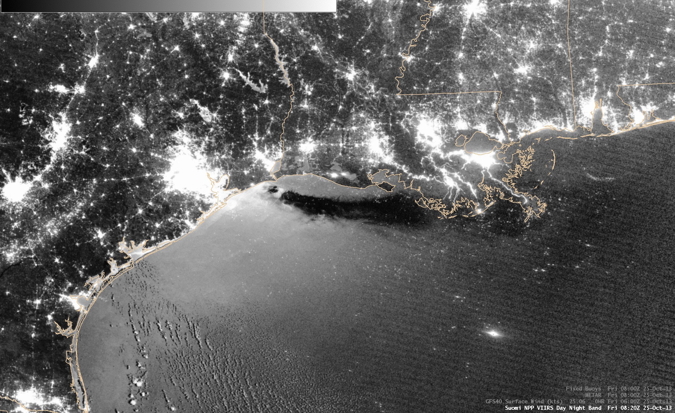 [Image from the NOAA/NASA Suomi-NPP satellite’s VIIRS sensor, October 25, 2013]
The light visible from the Moon can also help reveal a tropical cyclone’s intensity after the Sun has set. Moonlight helps scientists determine high, cirrus clouds from low-level liquid clouds, enabling them to analyze a storm’s circulation. In this image, moonlight reflected off the clouds of Super Typhoon Wutip revealed mesovortices within the eye of the typhoon, indicating a very strong and well-organized storm.
[Image from the NOAA/NASA Suomi-NPP satellite’s VIIRS sensor, October 25, 2013]
The light visible from the Moon can also help reveal a tropical cyclone’s intensity after the Sun has set. Moonlight helps scientists determine high, cirrus clouds from low-level liquid clouds, enabling them to analyze a storm’s circulation. In this image, moonlight reflected off the clouds of Super Typhoon Wutip revealed mesovortices within the eye of the typhoon, indicating a very strong and well-organized storm.
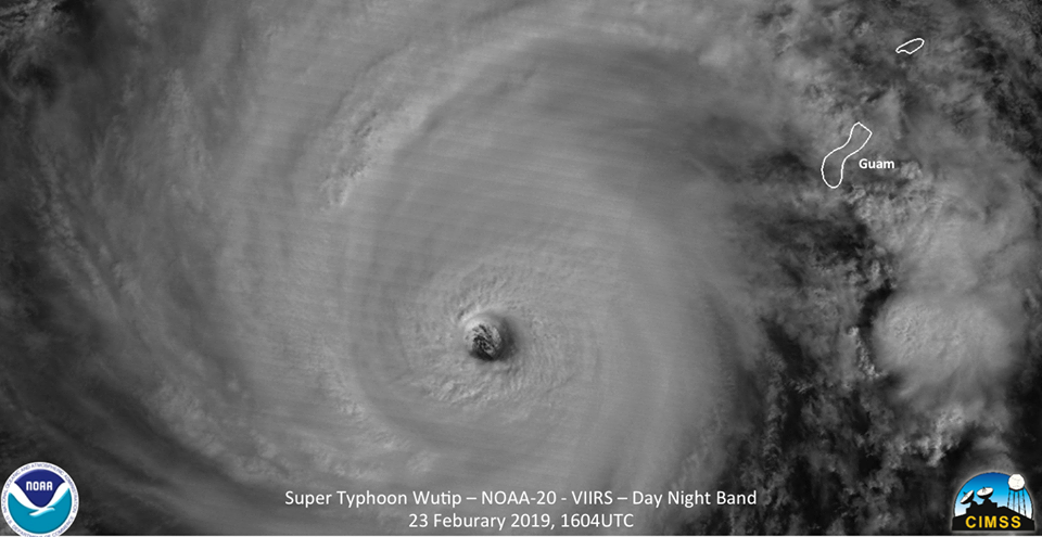 [Image from the NOAA-20 satellite’s VIIRS sensor, February 23, 2019]
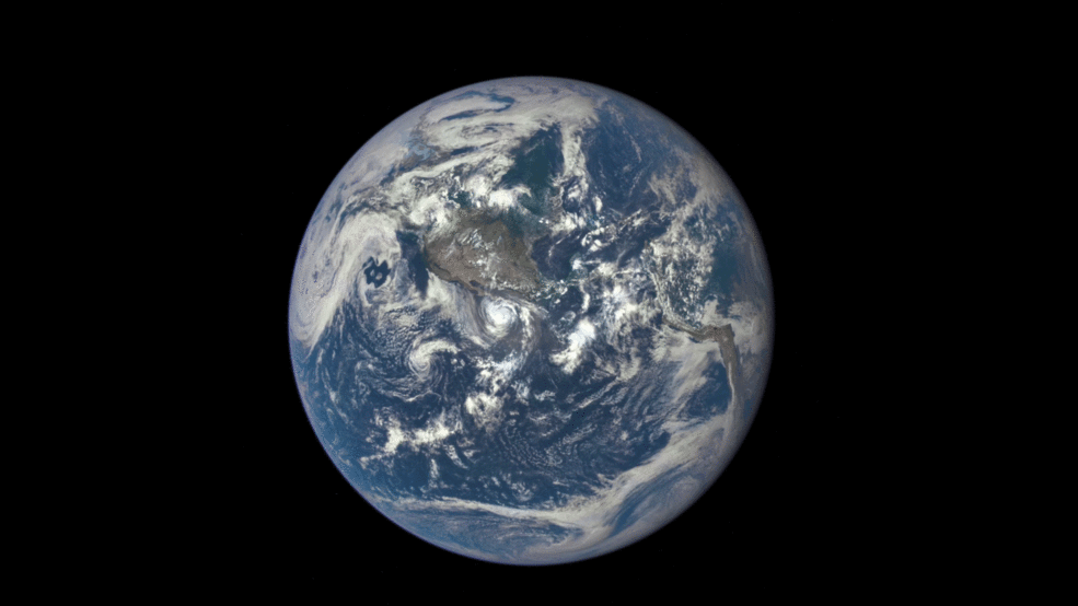 [Time lapse of the Moon’s transit across the Earth’s disk from DSCOVR’s EPIC, July 16, 2015, courtesy NASA]
From its position in space, EPIC provides a view of the farside of the Moon--which faces the Sun--that is never directly visible to us here on Earth. It also has captured the Moon’s shadow as it travels across the globe during solar eclipses, like the total solar eclipse that crossed the U.S. in 2017.
[Time lapse of the Moon’s transit across the Earth’s disk from DSCOVR’s EPIC, July 16, 2015, courtesy NASA]
From its position in space, EPIC provides a view of the farside of the Moon--which faces the Sun--that is never directly visible to us here on Earth. It also has captured the Moon’s shadow as it travels across the globe during solar eclipses, like the total solar eclipse that crossed the U.S. in 2017.
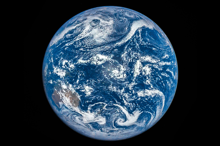 [Time lapse of the Moon’s shadow passing across the Earth during a total solar eclipse from DSCOVR’s EPIC, March 9, 2016, courtesy NASA]
From three very different perspectives, NOAA’s satellites don’t just provide us with critical environmental data and life-saving weather information. They also occasionally let us marvel at our own natural satellite that has fascinated and inspired humans for millennia.
Edited for WeatherNation by Mace Michaels
[Time lapse of the Moon’s shadow passing across the Earth during a total solar eclipse from DSCOVR’s EPIC, March 9, 2016, courtesy NASA]
From three very different perspectives, NOAA’s satellites don’t just provide us with critical environmental data and life-saving weather information. They also occasionally let us marvel at our own natural satellite that has fascinated and inspired humans for millennia.
Edited for WeatherNation by Mace Michaels
Geostationary Glances
NOAA’s latest generation of Geostationary Operational Environmental Satellites, GOES-R, orbit at 22,300 miles above Earth. In this position, they orbit the Earth’s equator at the same speed the Earth rotates. This keeps both satellites in a fixed position in the sky, and from here, they use their Advanced Baseline Imager (ABI) to track the evolution and movement of clouds, weather systems, tropical cyclones, and other environmental phenomena.
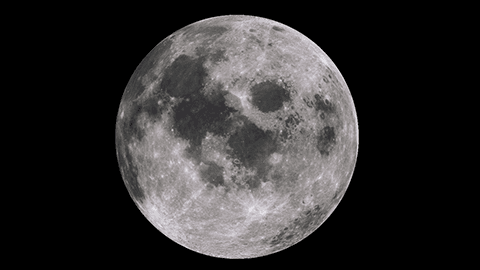
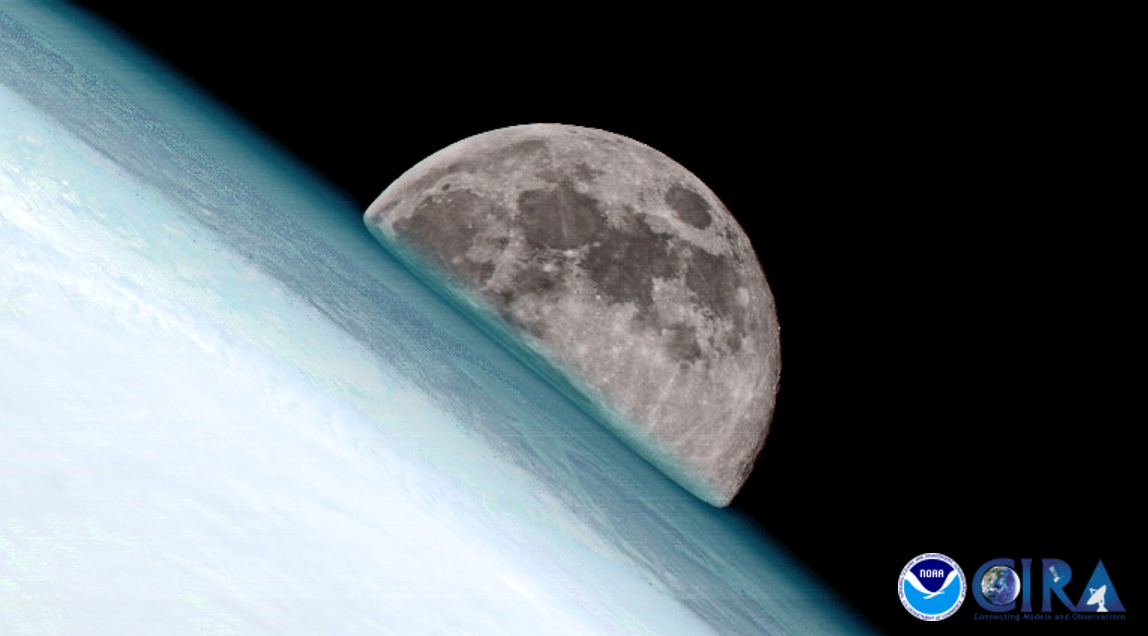
[Image from NOAA’s GOES-17 satellite, March 6, 2020]
This orbit is roughly one-tenth the average distance between the Earth and the Moon, and from this vantage point, the ABI instrument on both GOES-16 and GOES-17 regularly captures images of the Moon when it is near Earth’s limb, according to Joel McCorkel, GOES-R Project Scientist for NASA Goddard.
“Besides providing this captivating view, the signal from the Moon provides an independent reference of ABI’s radiometric stability for the reflected solar bands,” McCorkel said. “This signal is not directly used for operational image creation; however, it helps assess the quality and variability of the satellites’ operational calibration.”
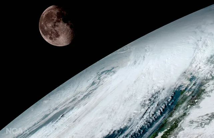
[Image from NOAA’s GOES-16 satellite, January 15, 2017]
Polar Peeks
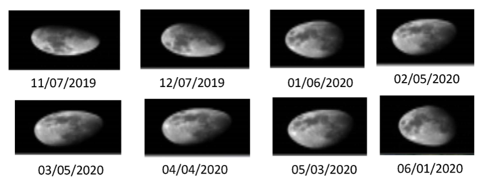
Orbiting much closer to Earth—roughly 500 miles above the surface—the NOAA Joint Polar Satellite System (JPSS) satellites depend on the Moon to function properly as well. And like GOES, both NOAA-20 and the NOAA-NASA Suomi NPP satellites have instruments that can see the Moon from their perch, according to Changyong Cao, chief of the Satellite Calibration and Data Assimilation Branch at NOAA’s Center for Satellite Applications and Research. “The JPSS satellite instruments see the Moon from their polar orbit from either their ‘space view’, or through dedicated monthly spacecraft roll maneuvers to observe the Moon for accurate calibration,” he said. “Specifically, the VIIRS instrument on JPSS satellites heavily relies on monthly lunar calibration.”
[Images of the Moon from the JPSS satellites’ roll maneuvers, from November 2019-June 2020]
VIIRS, the Visible Infrared Imaging Radiometer Suite, is one of the key instruments onboard the JPSS satellites. It has a Day-Night Band (DNB) that is extremely sensitive to light sources. From hundreds of miles up, VIIRS can detect city lights, lightning, fires, and moonlight reflecting off clouds at night. With the Moon as its only light source, the DNB can also detect snow cover, the motion of smoke and dust, and the movement of ice in polar regions.
What’s more, a phenomenon called moon glint, where the satellite captures the reflected moonlight off water bodies, can help pinpoint areas of light winds over water at night. The image below from the DNB shows how the calm water off the Texas coast acts like a mirror and reflects the bright moonlight back at the sensor.
[Image from the NOAA/NASA Suomi-NPP satellite’s VIIRS sensor, October 25, 2013]
The light visible from the Moon can also help reveal a tropical cyclone’s intensity after the Sun has set. Moonlight helps scientists determine high, cirrus clouds from low-level liquid clouds, enabling them to analyze a storm’s circulation. In this image, moonlight reflected off the clouds of Super Typhoon Wutip revealed mesovortices within the eye of the typhoon, indicating a very strong and well-organized storm.
[Image from the NOAA-20 satellite’s VIIRS sensor, February 23, 2019]
L1 Looks
About one million miles away from Earth is NOAA’s Deep Space Climate Observatory (DSCOVR) satellite. In this position--called L1, for Lagrangian point 1—the satellite provides real-time solar wind observations that are critical for maintaining the accuracy and lead-time of NOAA’s space weather alerts and forecasts. Onboard DSCOVR, there is also a NASA-operated camera called the Earth Polychromatic Imaging Camera (EPIC), which points toward our planet and occasionally shows us the celestial dance between the Earth and Moon . About twice a year the camera captures the Moon and Earth together as the orbit of DSCOVR crosses the orbital plane of the Moon.
[Time lapse of the Moon’s shadow passing across the Earth during a total solar eclipse from DSCOVR’s EPIC, March 9, 2016, courtesy NASA]
From three very different perspectives, NOAA’s satellites don’t just provide us with critical environmental data and life-saving weather information. They also occasionally let us marvel at our own natural satellite that has fascinated and inspired humans for millennia.
Edited for WeatherNation by Mace MichaelsAll Weather News
More
Fronts Continue To Spark Severe Weather Across the Plains
A cold front that brought record lows to the
18 Jul 2025 10:40 PM

Extreme Heat Impacts for the East Coast & South
Extreme heat continues to impact several area
18 Jul 2025 10:05 PM

Flooding Threat Remains Elevated in the East
A cold front pushing through the Eastern Seab
18 Jul 2025 9:10 PM

EF-2 Firenado from the Deer Creek Fire in Utah
A fire tornado was spotted near La Sal, Utah
18 Jul 2025 7:30 AM

Tropical System Brings Flood Risk to the Central Gulf
Time has run out for notable tropical develop
18 Jul 2025 3:05 AM

Heavy Rain, Flooding Threat Returns to Florida
Keep the rain boots handy in Florida - heavy
13 Jul 2025 12:50 PM

Severe Storm Risk Pushes into the Great Lakes, Ohio Valley
Friday was another busy day with severe weath
12 Jul 2025 8:00 PM