Another Record Day, in Terms of Temperatures
Special Stories
23 Feb 2018 7:45 PM
The East and the West coasts were feeling much different on Friday. Both were feeling record temperatures, just that it was cold across the West and hot across the East.
https://twitter.com/WeatherNation/status/967176670862983169
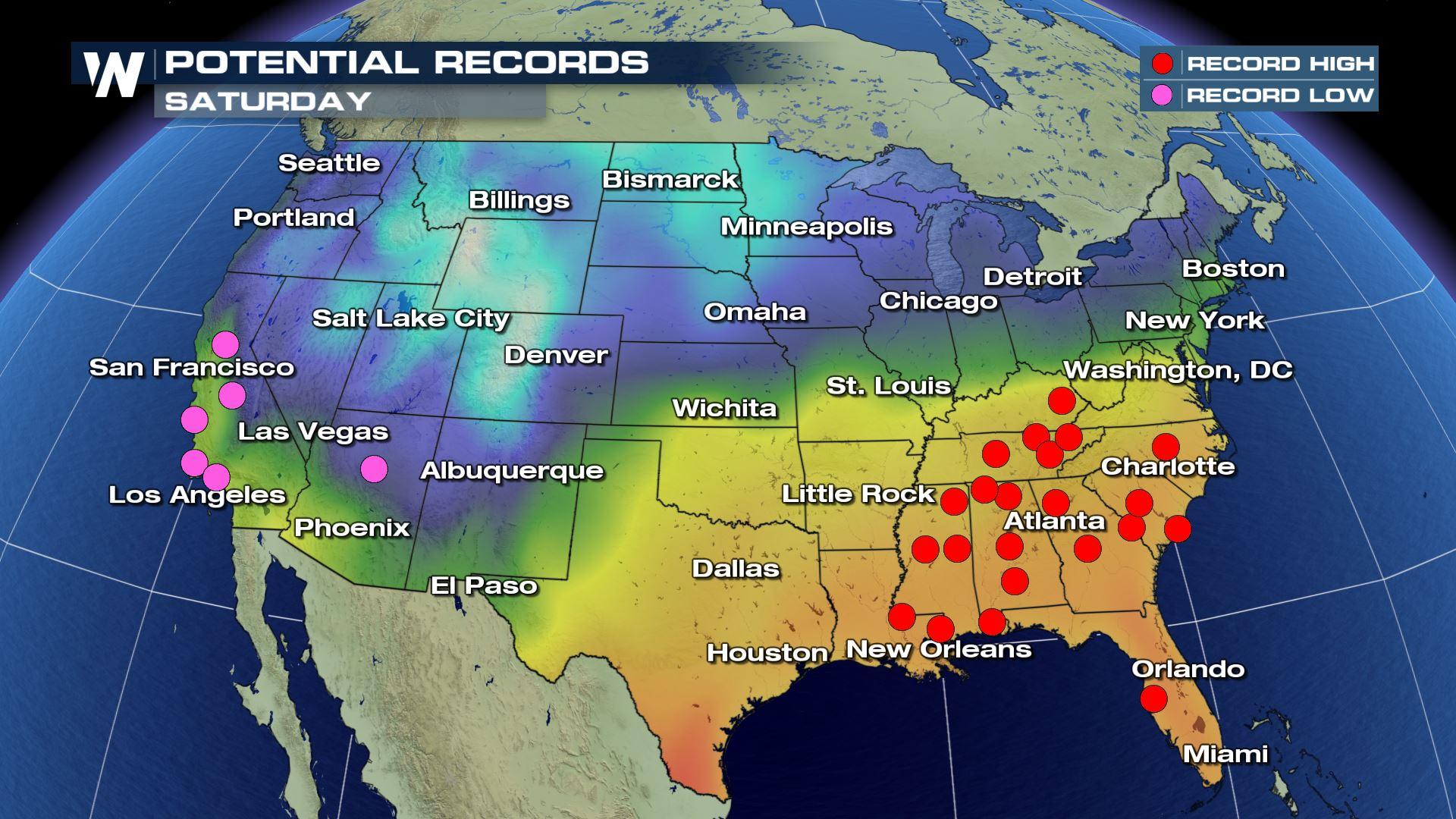
Dozens of record high temperatures were set from West Virginia to North Carolina, and across Texas, Louisiana and Florida. This comes on the heels of record high temperatures earlier in the week where some cities in the Northeast hit 80 degrees, some of the warmest numbers every recorded in the month of February for those locales.
But things tend to balance out and the "scale" was tipped in the other direction to record cold across the West.
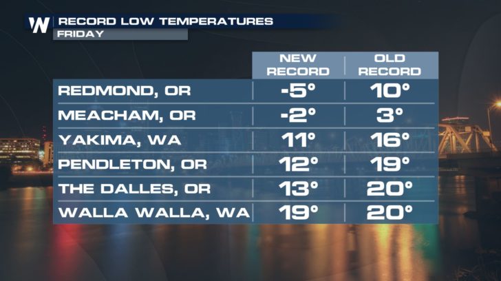 Bitterly cold temperatures sunk into Oregon and Washington, the continued story of the week here. This cold weather comes on the heels of record snowfall in Oregon.
https://twitter.com/WeatherNation/status/966871185051889667
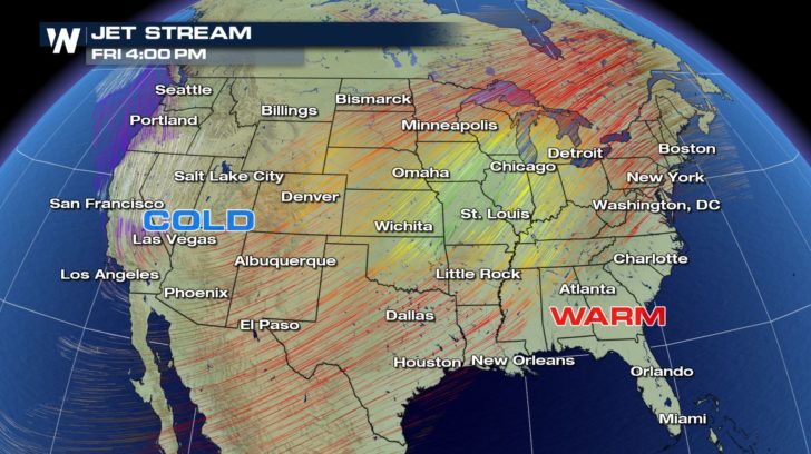
We have seen the development of a high amplitude weather pattern this week. That means the jet stream is taking big dips and rises across the Lower 48. Where it dips south, it allows colder air to rush in and vice versa the large rise in the jet stream allows warmth to be pumped in.
Bitterly cold temperatures sunk into Oregon and Washington, the continued story of the week here. This cold weather comes on the heels of record snowfall in Oregon.
https://twitter.com/WeatherNation/status/966871185051889667
We have seen the development of a high amplitude weather pattern this week. That means the jet stream is taking big dips and rises across the Lower 48. Where it dips south, it allows colder air to rush in and vice versa the large rise in the jet stream allows warmth to be pumped in.
 As we look at the weekend ahead, it appears it'll be kicked off by more of the same. Saturday morning may feature record low temperatures in parts of Arizona and California, while record high temperatures will be possible in much of the Southeast.
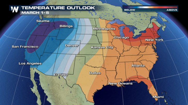
 On the long term, February is expected to end in a similar fashion of colder to the west and warmer to the east. Into the early part of March this may be the case as well.
 For WeatherNation, Meteorologist Steve Glazier
Bitterly cold temperatures sunk into Oregon and Washington, the continued story of the week here. This cold weather comes on the heels of record snowfall in Oregon.
https://twitter.com/WeatherNation/status/966871185051889667
We have seen the development of a high amplitude weather pattern this week. That means the jet stream is taking big dips and rises across the Lower 48. Where it dips south, it allows colder air to rush in and vice versa the large rise in the jet stream allows warmth to be pumped in.
As we look at the weekend ahead, it appears it'll be kicked off by more of the same. Saturday morning may feature record low temperatures in parts of Arizona and California, while record high temperatures will be possible in much of the Southeast.
On the long term, February is expected to end in a similar fashion of colder to the west and warmer to the east. Into the early part of March this may be the case as well.
For WeatherNation, Meteorologist Steve GlazierAll Weather News
More
Fronts Continue To Spark Severe Weather Across the Plains
A cold front that brought record lows to the
18 Jul 2025 10:40 PM

Extreme Heat Impacts for the East Coast & South
Extreme heat continues to impact several area
18 Jul 2025 10:05 PM

Flooding Threat Remains Elevated in the East
A cold front pushing through the Eastern Seab
18 Jul 2025 9:10 PM

EF-2 Firenado from the Deer Creek Fire in Utah
A fire tornado was spotted near La Sal, Utah
18 Jul 2025 7:30 AM

Tropical System Brings Flood Risk to the Central Gulf
Time has run out for notable tropical develop
18 Jul 2025 3:05 AM

Heavy Rain, Flooding Threat Returns to Florida
Keep the rain boots handy in Florida - heavy
13 Jul 2025 12:50 PM

Severe Storm Risk Pushes into the Great Lakes, Ohio Valley
Friday was another busy day with severe weath
12 Jul 2025 8:00 PM