April to June Outlook from NOAA's Climate Prediction Center

Special Stories
25 Mar 2019 2:00 PM
NOAA's Climate Prediction Center recently issued their new 90 day outlook, covering April, May, and June. Below-average temperatures are most likely in the Central and Southern Plains, where the saturated ground will slow down the seasonal warm up. Odds for a much warmer than average spring are likely in areas east of the Mississippi, and in the West and Pacific Northwest.
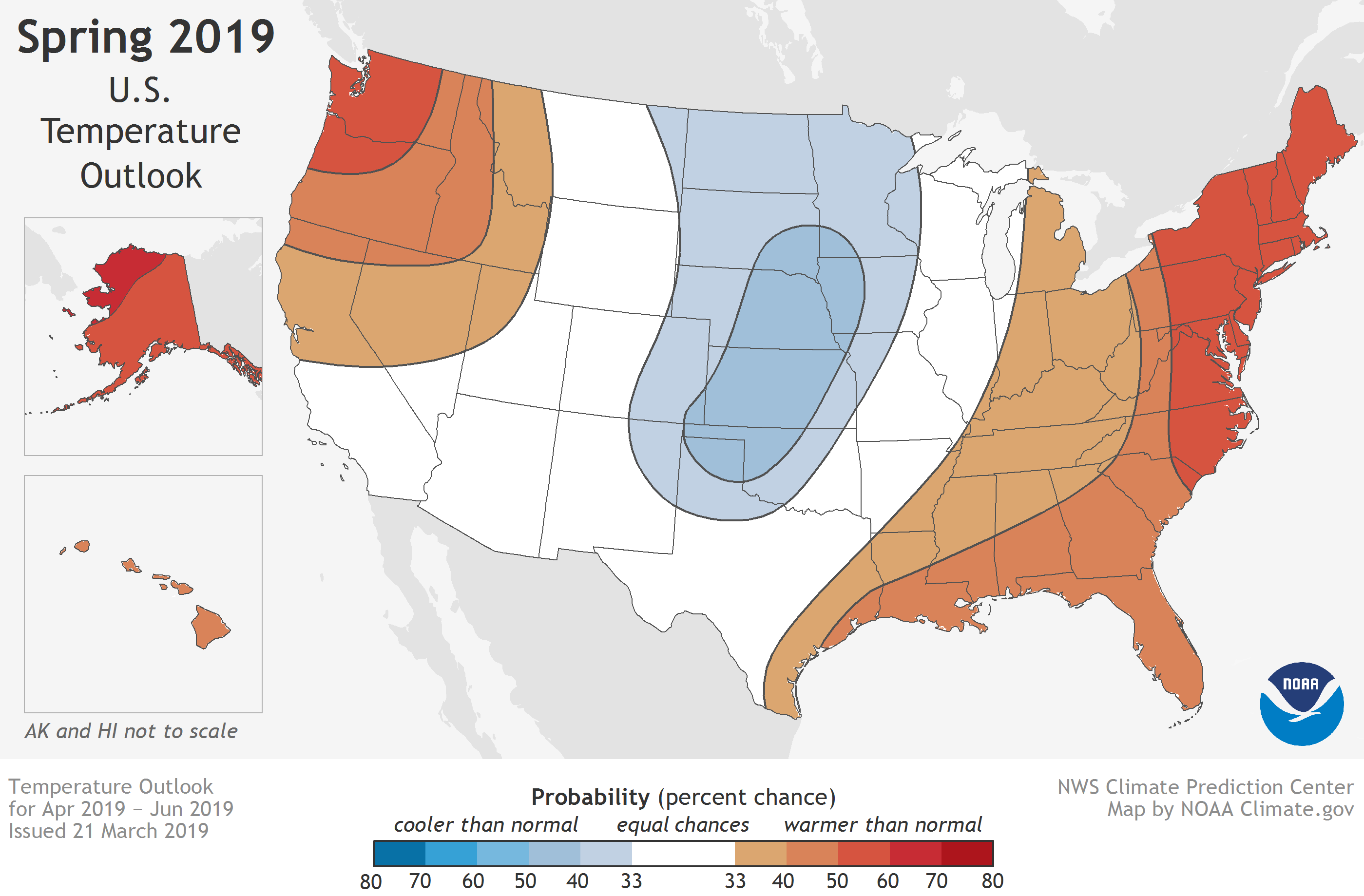 [Shades of blue and red show the chances of an unusually wet or dry spring (April-May) in 2019. "Unusually wet or dry" means seasonal average temperature in the top or bottom third of the climatological record (1981-2010). Darker colors mean higher chances (greater confidence in the forecast), not how warm or cool the conditions will be. NOAA Climate map, based on data from the Climate Prediction Center.]
The Spring flood outlook issued last week highlighted nearly two-thirds of the Lower 48 states facing an elevated risk for flooding through May, with the potential for major or moderate flooding in 25 states. The wet winter isn't the only contributor to the expansive flood risk. Across much of the country, the risk of well above average precipitation is elevated. (In any given year, the baseline probability for unusually wet, unusually dry, or near-average seasonal conditions is 33 percent each). For example, a swath of states along the southeastern seaboard and the Gulf Coast have a 40-50 percent chance of seasonal precipitation in the upper third of the climatological record. (That's compared to a 33 percent chance of near-average precipitation and a 17-27 percent chance of precipitation in the lower third of the climatological record.)
[Shades of blue and red show the chances of an unusually wet or dry spring (April-May) in 2019. "Unusually wet or dry" means seasonal average temperature in the top or bottom third of the climatological record (1981-2010). Darker colors mean higher chances (greater confidence in the forecast), not how warm or cool the conditions will be. NOAA Climate map, based on data from the Climate Prediction Center.]
The Spring flood outlook issued last week highlighted nearly two-thirds of the Lower 48 states facing an elevated risk for flooding through May, with the potential for major or moderate flooding in 25 states. The wet winter isn't the only contributor to the expansive flood risk. Across much of the country, the risk of well above average precipitation is elevated. (In any given year, the baseline probability for unusually wet, unusually dry, or near-average seasonal conditions is 33 percent each). For example, a swath of states along the southeastern seaboard and the Gulf Coast have a 40-50 percent chance of seasonal precipitation in the upper third of the climatological record. (That's compared to a 33 percent chance of near-average precipitation and a 17-27 percent chance of precipitation in the lower third of the climatological record.)
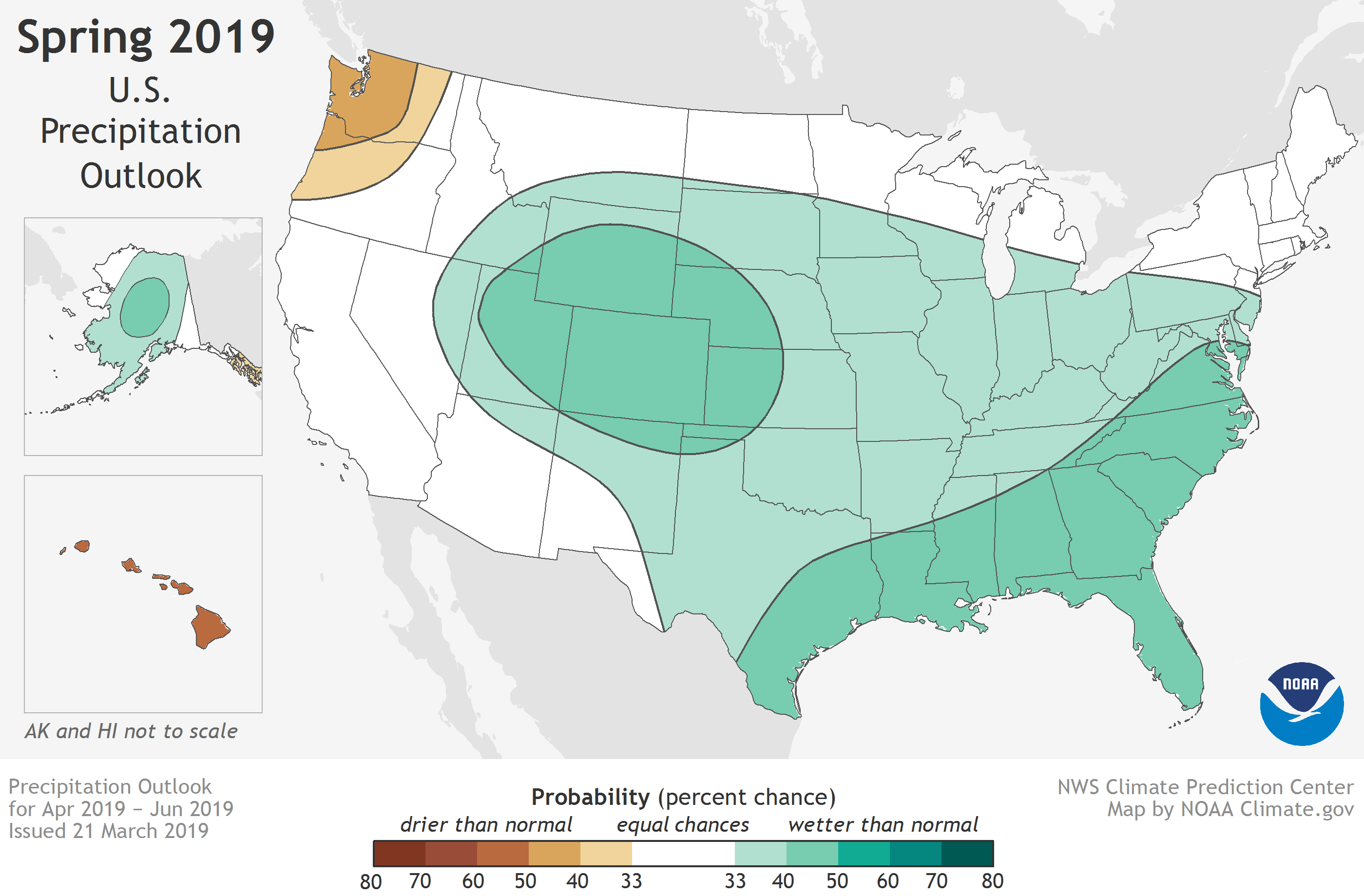 [Shades of green and brown show the chances of an unusually wet or dry spring (April-May) in 2019. "Unusually wet or dry" means seasonal average precipitation in the top or bottom third of the climatological record (1981-2010). Darker colors mean higher chances (greater confidence in the forecast),not how wet or dry the conditions will be. NOAA Climate map, based on data from the Climate Prediction Center.]
Information used also from NOAA. For WeatherNation: Meteorologist Mace Michaels
[Shades of green and brown show the chances of an unusually wet or dry spring (April-May) in 2019. "Unusually wet or dry" means seasonal average precipitation in the top or bottom third of the climatological record (1981-2010). Darker colors mean higher chances (greater confidence in the forecast),not how wet or dry the conditions will be. NOAA Climate map, based on data from the Climate Prediction Center.]
Information used also from NOAA. For WeatherNation: Meteorologist Mace Michaels
[Shades of blue and red show the chances of an unusually wet or dry spring (April-May) in 2019. "Unusually wet or dry" means seasonal average temperature in the top or bottom third of the climatological record (1981-2010). Darker colors mean higher chances (greater confidence in the forecast), not how warm or cool the conditions will be. NOAA Climate map, based on data from the Climate Prediction Center.]
The Spring flood outlook issued last week highlighted nearly two-thirds of the Lower 48 states facing an elevated risk for flooding through May, with the potential for major or moderate flooding in 25 states. The wet winter isn't the only contributor to the expansive flood risk. Across much of the country, the risk of well above average precipitation is elevated. (In any given year, the baseline probability for unusually wet, unusually dry, or near-average seasonal conditions is 33 percent each). For example, a swath of states along the southeastern seaboard and the Gulf Coast have a 40-50 percent chance of seasonal precipitation in the upper third of the climatological record. (That's compared to a 33 percent chance of near-average precipitation and a 17-27 percent chance of precipitation in the lower third of the climatological record.)
[Shades of green and brown show the chances of an unusually wet or dry spring (April-May) in 2019. "Unusually wet or dry" means seasonal average precipitation in the top or bottom third of the climatological record (1981-2010). Darker colors mean higher chances (greater confidence in the forecast),not how wet or dry the conditions will be. NOAA Climate map, based on data from the Climate Prediction Center.]
Information used also from NOAA. For WeatherNation: Meteorologist Mace MichaelsAll Weather News
More


More Storms for the East Sunday and Monday
A low-pressure system crashing through the Mi
2 Aug 2026 2:20 AM

After Reaching Category 5, Genevieve Weakens in the Pacific
PacificGenevieve formed on last Friday south
2 Aug 2026 1:30 AM

Flooding, Severe Storms Target the Midwest Again
After an active week of storms across the nor
1 Aug 2026 1:40 AM

Flooding Risk Increases as Heavy Rain Targets the Tri-State Area
Tuesday, heavy rainfall moved across the Nort
30 Jul 2026 12:25 AM

Severe Weather: Energy From the Midwest Now in the Southeast
UPPER MIDWEST - Through Monday, dangerous tor
29 Jul 2026 10:30 PM