Army Corp to Open Spillway near New Orleans to Lower Mississippi River Levels
Special Stories
3 Apr 2020 10:00 AM
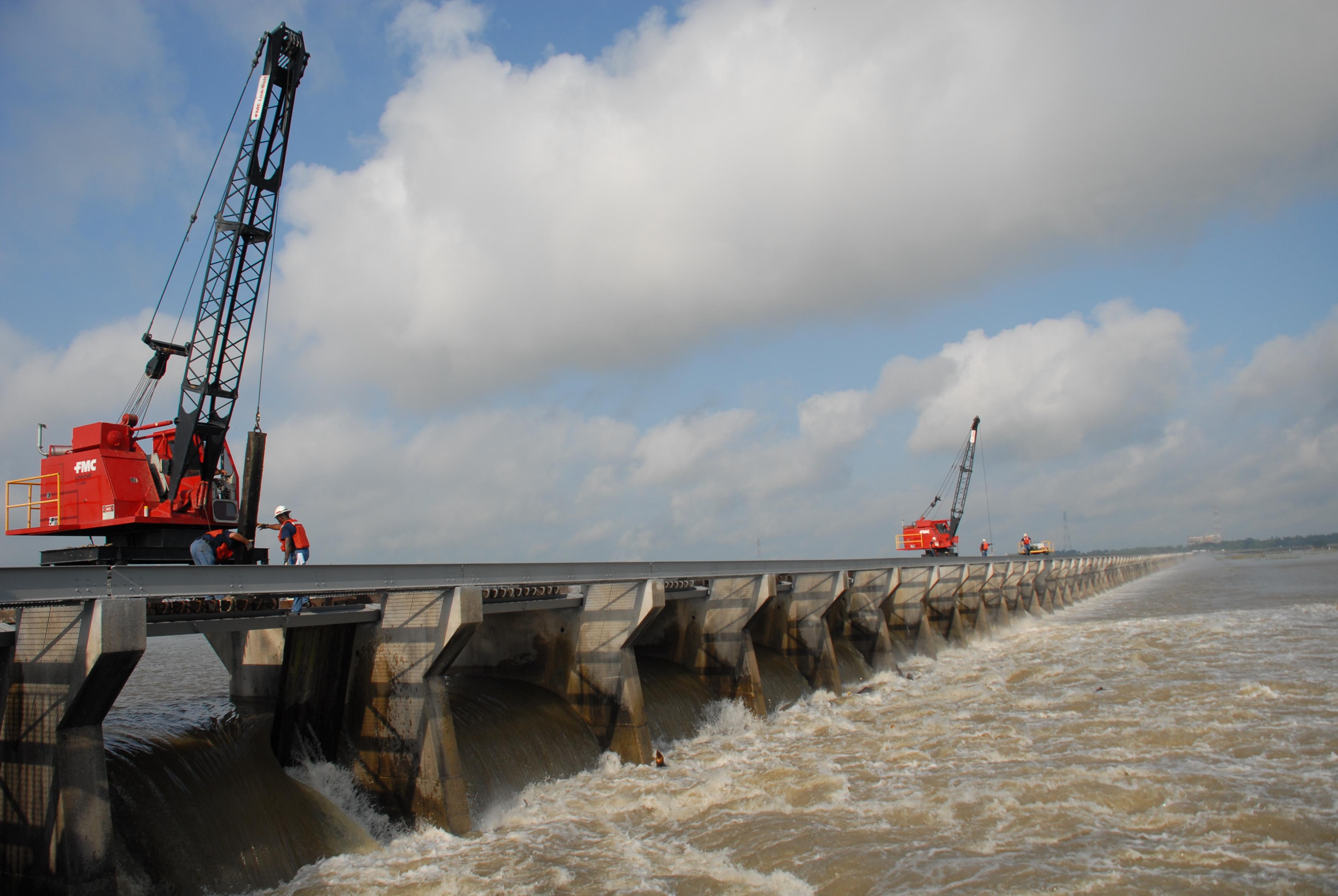
[The Bonnet Carre Spillway diverting excess Mississippi River water in May of 2011. Photo courtesy of the U.S. Army Corps of Engineers via Wikimedia Commons]
Heavy rain in the Mississippi Valley and rising Mississippi River water stages and flow are prompting the U.S. Army Corps of Engineers to open the Bonnet Carré Spillway Friday. This will lower water levels downstream and should keep the Mississippi under flood stage in New Orleans. Major General Mark Toy, Commanding General of the Mississippi Valley Division, made the decision Thursday to open Bonnet Carré.
“In the Mississippi Valley Division, our priority is taking care of people,” said Toy. “When we operate the spillway, we do everything we can to help mitigate the impacts. And, the decision to do so is not taken lightly. By operating the Bonnet Carré Spillway, we can safely pass these high waters and ultimately keep people safe.”
https://twitter.com/TeamNewOrleans/status/1246092326885306368
Environmental, hydrologic, structural, and navigational considerations all bear on the decision to open Bonnet Carré. Other factors that affect the decision are the overall condition of the levees and the ability of the river to pass flows, and the effects high water and river currents may have on vessels navigating the river. The Corps has a detailed environmental monitoring plan in place that will assess water quality, dissolved oxygen, sedimentation, recreation, and natural resources such as the pallid sturgeon, both within the spillway as well as Lake Pontchartrain.
According to the Associated Press, this is the third straight year he spillway has been opened and sixth time in the last decade. The last time that happened was in the 1970s. Before 2011, the spillway had averaged only one opening every decade, says the New Orleans Times-Picayune.
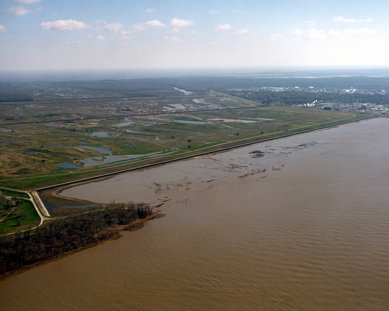 [The opening of the Bonnet Carré Spillway on the Mississippi River in 1999. The spillway is designed to move water from the river into Lake Pontchartrain during flooding of the river. Lake Pontchartrain can be seen in the far distance. Photo courtesy of the U.S. Army Corps of Engineers via Wikimedia Commons.]
The Bonnet Carré Spillway, located 28 miles above New Orleans, is a vital element of the multi-state Mississippi River and Tributaries (MR&T) system, which uses a variety of features to provide flood risk reduction to the alluvial Mississippi Valley from Cape Girardeau, MO to Head of Passes, LA. Located on the east bank in St. Charles Parish, it can divert a portion of the river's floodwaters via Lake Pontchartrain into the Gulf of Mexico, thus allowing high water to bypass New Orleans and other nearby river communities. The structure has a design capacity of 250,000 cfs, the equivalent of roughly 1,870,000 gallons per second. Rates higher than 1.25 million cfs will stress the levies in New Orleans, producing flooding.
The Bonnet Carré structure consists of a control structure and a floodway. The control structure is a concrete weir that parallels the river for a mile and a half. It consists of 350 gated bays, each holding 20 timber "needles," for a total of 7,000 needles. When needles are removed, river water flows into the floodway and is conveyed nearly six miles between guide levees to the lake. Operation of the structure is relatively simple. Two cranes, moving on tracks atop the structure, lift timbers from their vertical position in the weir and set them horizontally across the top of the structure to allow river water into the spillway.
https://www.facebook.com/usacenola/videos/1153407661662643/
[Army Corps press conference from Thursday, April 2, announcing the opening. Audio starts around 2:25]
Information above from the U.S. Army Corp of Engineers press release
[The opening of the Bonnet Carré Spillway on the Mississippi River in 1999. The spillway is designed to move water from the river into Lake Pontchartrain during flooding of the river. Lake Pontchartrain can be seen in the far distance. Photo courtesy of the U.S. Army Corps of Engineers via Wikimedia Commons.]
The Bonnet Carré Spillway, located 28 miles above New Orleans, is a vital element of the multi-state Mississippi River and Tributaries (MR&T) system, which uses a variety of features to provide flood risk reduction to the alluvial Mississippi Valley from Cape Girardeau, MO to Head of Passes, LA. Located on the east bank in St. Charles Parish, it can divert a portion of the river's floodwaters via Lake Pontchartrain into the Gulf of Mexico, thus allowing high water to bypass New Orleans and other nearby river communities. The structure has a design capacity of 250,000 cfs, the equivalent of roughly 1,870,000 gallons per second. Rates higher than 1.25 million cfs will stress the levies in New Orleans, producing flooding.
The Bonnet Carré structure consists of a control structure and a floodway. The control structure is a concrete weir that parallels the river for a mile and a half. It consists of 350 gated bays, each holding 20 timber "needles," for a total of 7,000 needles. When needles are removed, river water flows into the floodway and is conveyed nearly six miles between guide levees to the lake. Operation of the structure is relatively simple. Two cranes, moving on tracks atop the structure, lift timbers from their vertical position in the weir and set them horizontally across the top of the structure to allow river water into the spillway.
https://www.facebook.com/usacenola/videos/1153407661662643/
[Army Corps press conference from Thursday, April 2, announcing the opening. Audio starts around 2:25]
Information above from the U.S. Army Corp of Engineers press releaseAll Weather News
More
Severe Threat Marches East This Afternoon
UPPER MIDWEST - Through Monday, dangerous tor
28 Jul 2026 4:25 PM

Tropics: Fausto Heads towards Hawaii; Genevieve Cat 4 Hurricane
PacificTropical Storm Fausto continues to tra
28 Jul 2026 4:20 PM


Southeast Flood Risk Lingers Near Stalled Front
A stalled boundary over the Southeast will ke
25 Jul 2026 10:55 AM

Another Round of Storms Targets the Northeast
Tuesday brought severe weather again across p
23 Jul 2026 1:15 AM

Another Round of Severe Weather for the Upper Midwest and Great Lakes
The upper-level low train continues to keep t
21 Jul 2026 1:45 AM