As Major Hurricane Florence Churns, What Should We Do?

Special Stories
5 Sep 2018 6:14 PM
Short answer, WATCH.
 The one thing we can all do with Florence is watch how the next few days unfold. As of the writing of this article, time is on our side. The five-day forecast (through Monday, September 10) keeps Hurricane Florence out over the open Atlantic Ocean waters. It's what happens after that which remains a huge question mark.
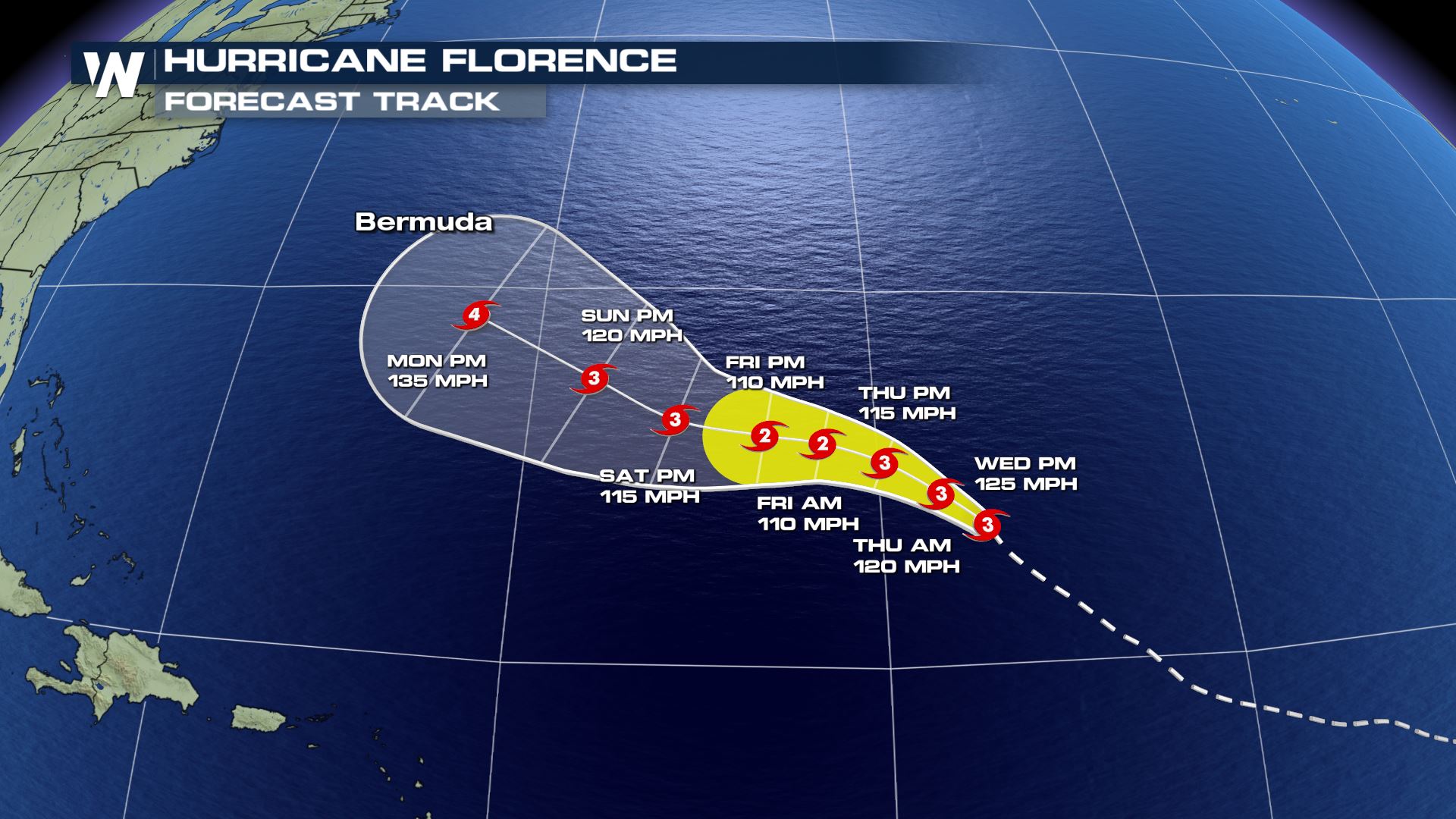
 Forecast models for the center of Hurricane Florence push the storm near Bermuda Monday-Tuesday and closer to the East coast by the 11th of September.
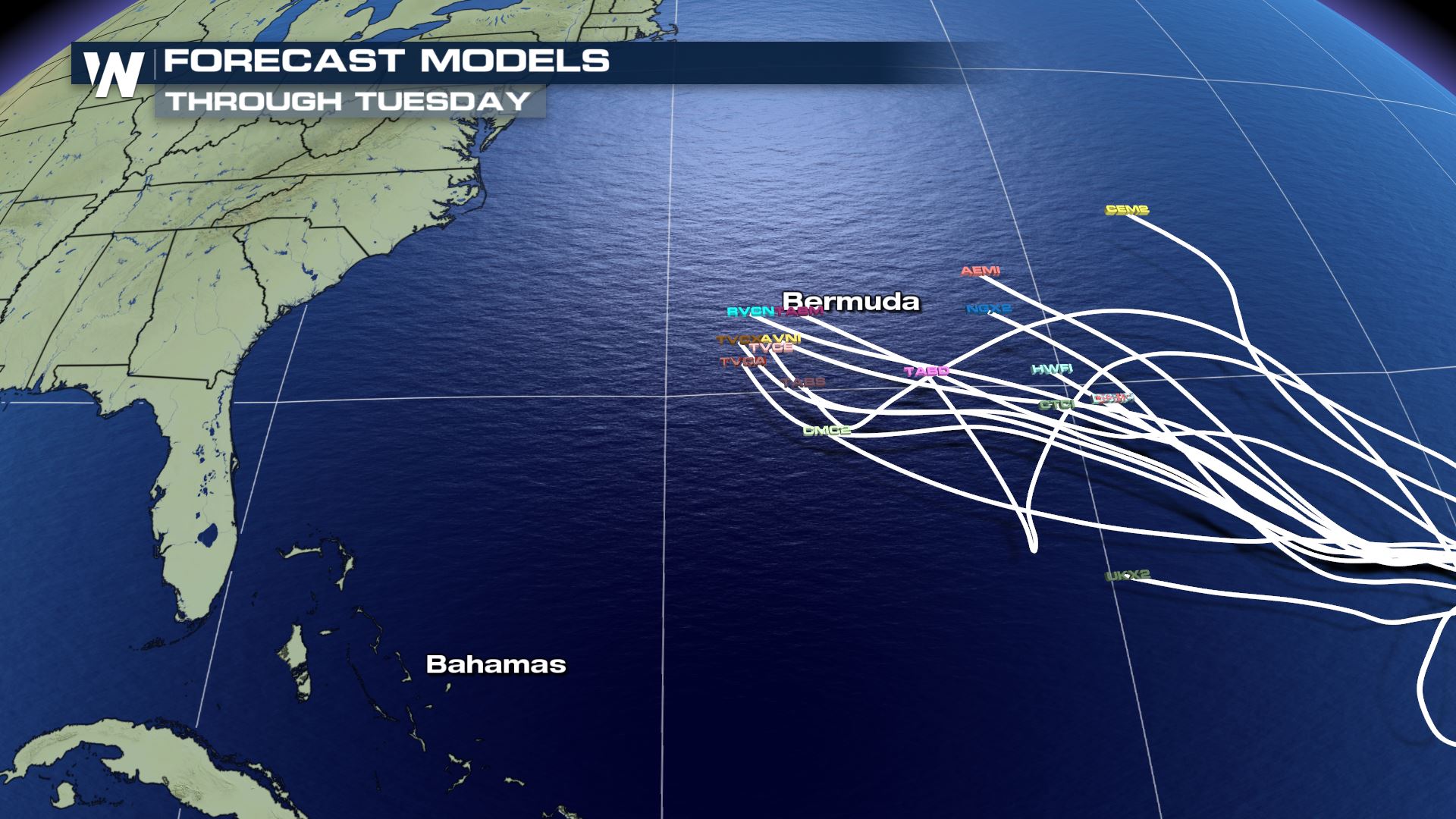
Most weather models keep pushing the center of Florence toward Bermuda through Tuesday, September 11 (also the peak of hurricane season). After that (Tuesday, 11th and beyond) models have taken the storm out to sea, while other models bring it narrowly close to the mid-Atlantic (Wednesday-Thursday, 12th-13th).
Forecast models for the center of Hurricane Florence push the storm near Bermuda Monday-Tuesday and closer to the East coast by the 11th of September.
Most weather models keep pushing the center of Florence toward Bermuda through Tuesday, September 11 (also the peak of hurricane season). After that (Tuesday, 11th and beyond) models have taken the storm out to sea, while other models bring it narrowly close to the mid-Atlantic (Wednesday-Thursday, 12th-13th).
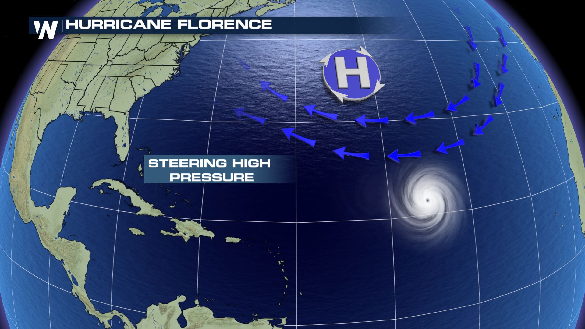 An unknown in this equation is the strength and location of the high pressure to the north of Florence. If the high weakens, Florence could find that weak spot and move north. On the contrary, the high could remain strong and steer Florence uncomfortably close to the U.S.
What should you do at this time?
An unknown in this equation is the strength and location of the high pressure to the north of Florence. If the high weakens, Florence could find that weak spot and move north. On the contrary, the high could remain strong and steer Florence uncomfortably close to the U.S.
What should you do at this time?
The one thing we can all do with Florence is watch how the next few days unfold. As of the writing of this article, time is on our side. The five-day forecast (through Monday, September 10) keeps Hurricane Florence out over the open Atlantic Ocean waters. It's what happens after that which remains a huge question mark.
Forecast models for the center of Hurricane Florence push the storm near Bermuda Monday-Tuesday and closer to the East coast by the 11th of September.
Most weather models keep pushing the center of Florence toward Bermuda through Tuesday, September 11 (also the peak of hurricane season). After that (Tuesday, 11th and beyond) models have taken the storm out to sea, while other models bring it narrowly close to the mid-Atlantic (Wednesday-Thursday, 12th-13th).
An unknown in this equation is the strength and location of the high pressure to the north of Florence. If the high weakens, Florence could find that weak spot and move north. On the contrary, the high could remain strong and steer Florence uncomfortably close to the U.S.
What should you do at this time?
- Monitor the daily forecast
- Think about the timing (Florence *could* be near the East coast Wednesday-Thursday (12th-13th) What do you have planned? What would you do in case of a tropical system?
- Double check your hurricane kit
- Ask us questions! We're here to answer you and provide the latest weather hazards/forecast
All Weather News
More
Texas and Oklahoma Severe Chances Friday
Another round of severe storms will be possib
22 May 2026 1:30 PM

Severe Storms, Heavy Rain Target the Southeast
Heavy rain has already hit numerous areas in
22 May 2026 12:02 PM

NOAA Predicts Below Normal 2026 Hurricane Season
NOAA has released their predictions for the 2
22 May 2026 12:00 PM

Repeated Rain Raises the Flood Threat
A slow-moving frontal boundary that brought n
22 May 2026 10:25 AM

NOAA Releases Summer Outlook, Above Average Temperatures Expected
The National Oceanic and Atmospheric Administ
22 May 2026 9:05 AM

CALIFORNIA: Wildfires Prompt Evacuations
SIMI VALLEY, CA - On Monday, May 18th in Vent
22 May 2026 2:00 AM

Rockies Brace for Snow, Severe Storms as Cold Front Moves In
ROCKIES - Through the rest of the week, an up
21 May 2026 5:30 PM