As March Begins, Temps Won't Change Much Across U.S.
Top Stories
26 Feb 2019 5:48 PM
March is almost here. It arrives on Friday, and as the calendar flips to a new month, we usually begin to transition into a new season. While spring officially arrives on the vernal equinox, (this year March 20th), meteorologists consider March 1st as the first day of spring. That's because the month of March usually offers widely varying temps and storms across the United States. Weather patterns may bring record warm temperatures one day, and bitter cold snow storms the next.
One of the biggest reasons for temperature fluctuations in March, over large areas, is the jet stream. The jet is a fast moving river of air, high in the atmosphere. The strongest jet streams, called Polar Jets, are high in the atmosphere, between 30,000 and 40,000 feet. They separate the colder air in the northern regions, from the warmer air in the southern regions.
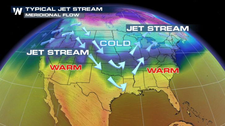
Typically, the jet stream undulates north and south, as it flows from the west to the east. When the jet flows to the north, it's called a ridge. This allows warm air to flow northward. When the jet flows to the south, it's called a trough. This allows cold air to flow southward.
In the diagram below, a typical jet stream pattern is illustrated. The jet is undulating north and south, allowing warm air and cold air to flow into different parts of the country. This pattern is called Meridional Flow. Warm air can been seen in the southwest and southeast. And colder air can be seen sinking southward into the central U.S.
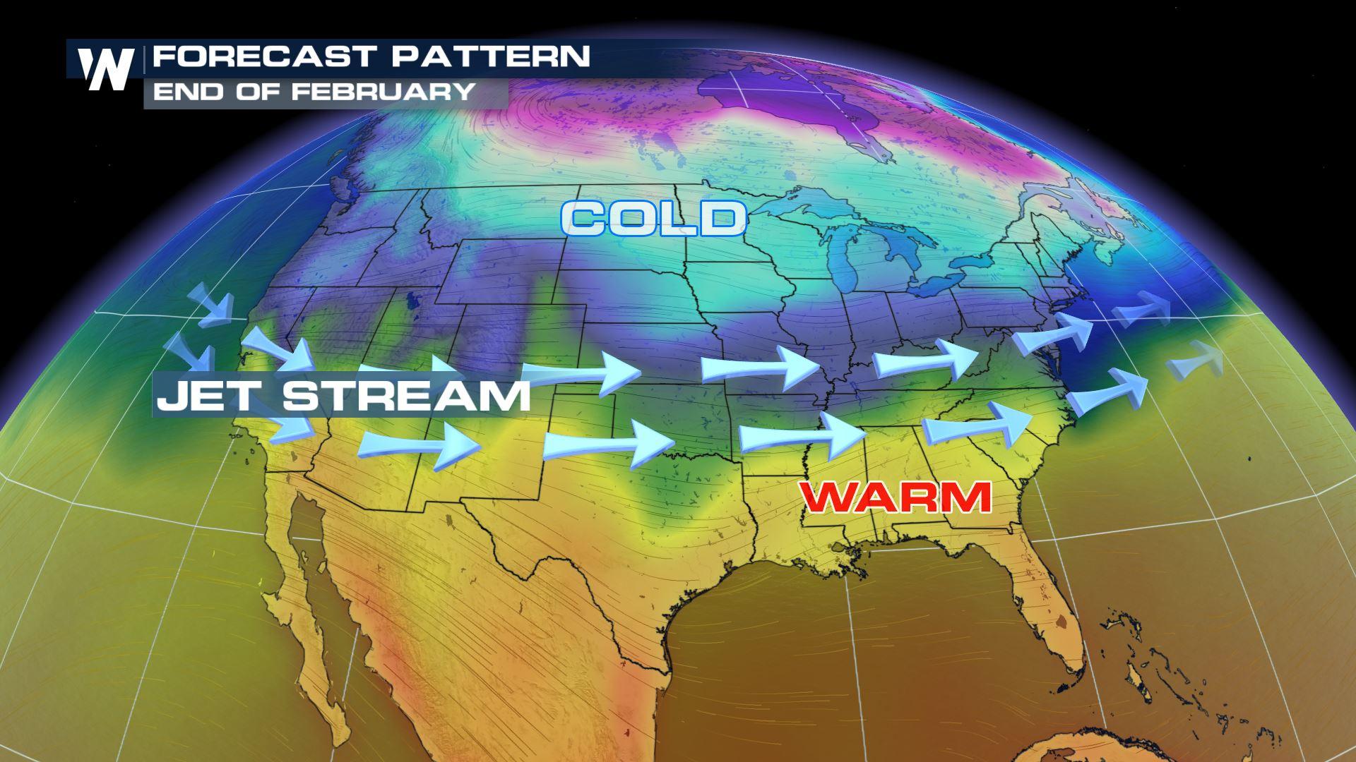
 However, the current jet stream pattern is not doing this. The jet is flowing almost directly west to east across the country. This pattern is called Zonal Flow. To the north of the jet we find cold air. To the south of the jet we find warm air. There is almost no north-south movement to the jet, and therefore, very little temperature transport to the north or south. This allows temps to remain relatively constant across the country. Cold areas stay cold. And warm areas stay warm. This will continue to be the case until the jet begins to meander north and south once again.
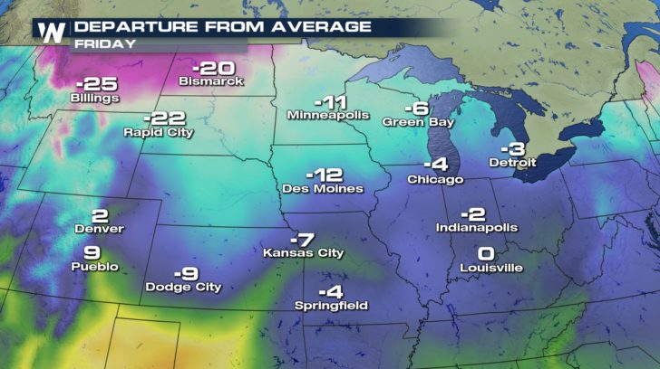
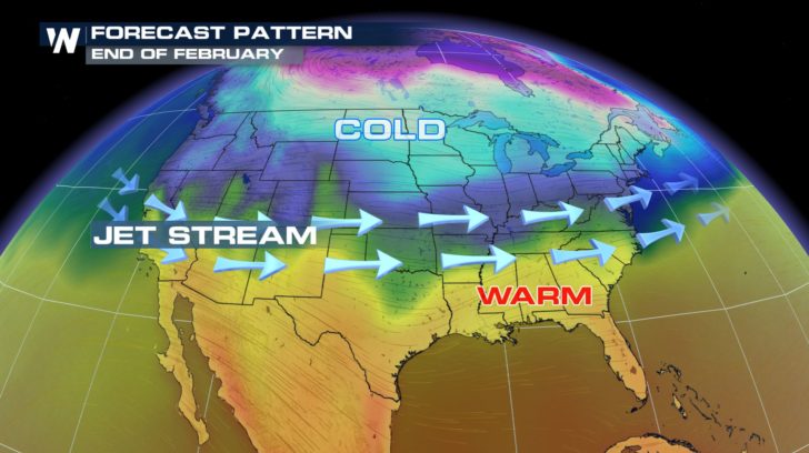 The current forecast keeps the jet in a zonal flow. So that means come Friday, March 1st, it will stay very cold in the north central U.S. Bismark will only see a high of 12 degrees. This is 20 degrees below average for this time of year. Billings will be 25 degrees colder then they usually are on March 1st.
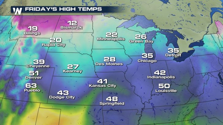
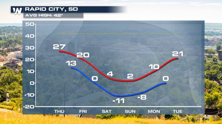
 Cities such as Rapid City, will stay well below their average high of 42 degrees right through next week. Weekend highs will only be 4 degrees on Saturday, and 2 degrees on Sunday. That's cold! And Sunday morning lows will drop to 10 degrees below zero. Frostbite is possible in just 10 minutes at that temperature.
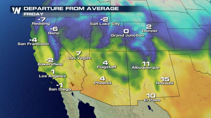
 On the flip side of the temperature scale, temps to the south of the jet stream will be quite pleasant. March 1st temps in Los Angeles will reach 64 degrees. Denver will be comfortable at 51 degrees. And folks in Phoenix will enjoy perfect golfing temps in the mid 70's. All of those numbers are very close to average for this time of year.
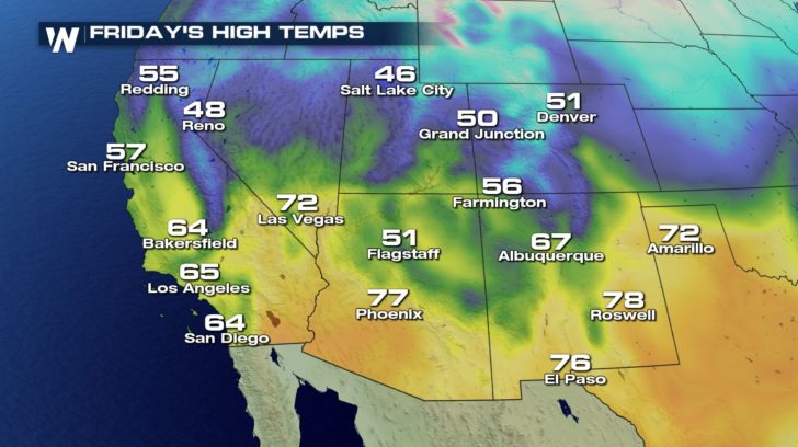
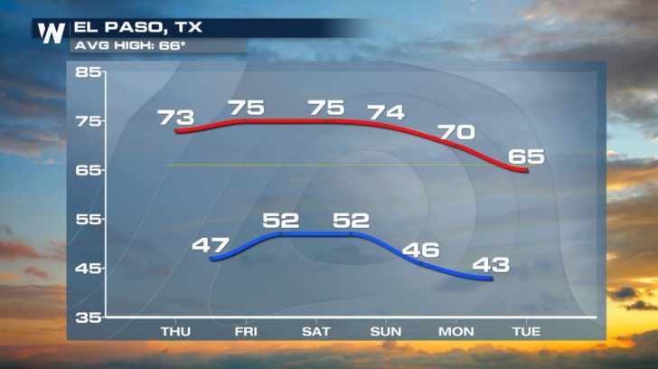
 El Paso will enjoy above average temps right through next Monday. The residents have the jet stream to thank for the warm temps.
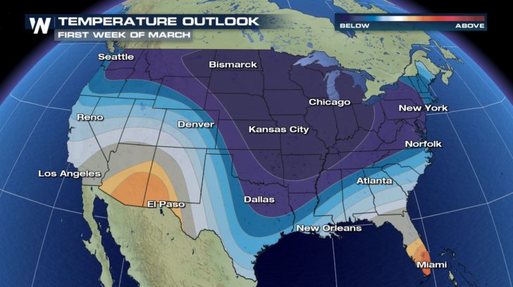
 Looking ahead for the first full week of March, it appears that cold air will be sinking southward into cities like Dallas, Little Rock, and Memphis. This would indicate that a trough will form in the jet stream.
 For the very latest forecast, you can watch WeatherNation TV on the Dish Network, Roku, Fire TV, Pluto, and Apple TV.
For WeatherNation: Meteorologist Matt Monroe
For the very latest forecast, you can watch WeatherNation TV on the Dish Network, Roku, Fire TV, Pluto, and Apple TV.
For WeatherNation: Meteorologist Matt Monroe
However, the current jet stream pattern is not doing this. The jet is flowing almost directly west to east across the country. This pattern is called Zonal Flow. To the north of the jet we find cold air. To the south of the jet we find warm air. There is almost no north-south movement to the jet, and therefore, very little temperature transport to the north or south. This allows temps to remain relatively constant across the country. Cold areas stay cold. And warm areas stay warm. This will continue to be the case until the jet begins to meander north and south once again.
The current forecast keeps the jet in a zonal flow. So that means come Friday, March 1st, it will stay very cold in the north central U.S. Bismark will only see a high of 12 degrees. This is 20 degrees below average for this time of year. Billings will be 25 degrees colder then they usually are on March 1st.
Cities such as Rapid City, will stay well below their average high of 42 degrees right through next week. Weekend highs will only be 4 degrees on Saturday, and 2 degrees on Sunday. That's cold! And Sunday morning lows will drop to 10 degrees below zero. Frostbite is possible in just 10 minutes at that temperature.
On the flip side of the temperature scale, temps to the south of the jet stream will be quite pleasant. March 1st temps in Los Angeles will reach 64 degrees. Denver will be comfortable at 51 degrees. And folks in Phoenix will enjoy perfect golfing temps in the mid 70's. All of those numbers are very close to average for this time of year.
El Paso will enjoy above average temps right through next Monday. The residents have the jet stream to thank for the warm temps.
Looking ahead for the first full week of March, it appears that cold air will be sinking southward into cities like Dallas, Little Rock, and Memphis. This would indicate that a trough will form in the jet stream.
For the very latest forecast, you can watch WeatherNation TV on the Dish Network, Roku, Fire TV, Pluto, and Apple TV.
For WeatherNation: Meteorologist Matt MonroeAll Weather News
More
Flooding Risk Increases as Heavy Rain Targets the Tri-State Area
Tuesday, heavy rainfall moved across the Nort
30 Jul 2026 12:25 AM


Genevieve Down to a Category 2 Hurricane
PacificFausto is now a post-tropical cyclone.
30 Jul 2026 12:00 AM

Severe Weather: Energy From the Midwest Now in the Southeast
UPPER MIDWEST - Through Monday, dangerous tor
29 Jul 2026 10:30 PM


Southeast Flood Risk Lingers Near Stalled Front
A stalled boundary over the Southeast will ke
25 Jul 2026 10:55 AM

Another Round of Storms Targets the Northeast
Tuesday brought severe weather again across p
23 Jul 2026 1:15 AM