Atlantic Tropical Activity Heating Up
Special Stories
4 Jul 2018 12:10 PM
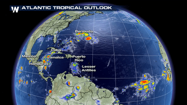
The Atlantic tropical activity is finally showing signs of life after a very quiet June. There are currently 2 areas of interest in the Atlantic.
https://twitter.com/WeatherNation/status/1014659588585451520
An area of disorganized showers and thunderstorms well off the east coast and west of Bermuda could further organize into a tropical depression by the end of the week. It is expected to stay between Bermuda and the coast, eventually catching up to the cold front sliding off the eastern U.S., which would allow the system to weaken and lose it's tropical characteristics.
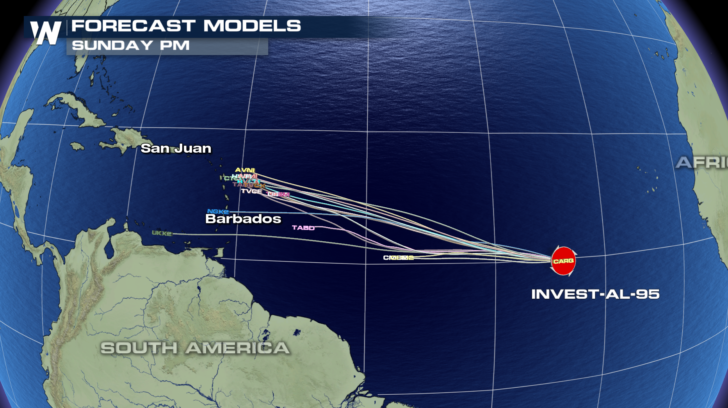
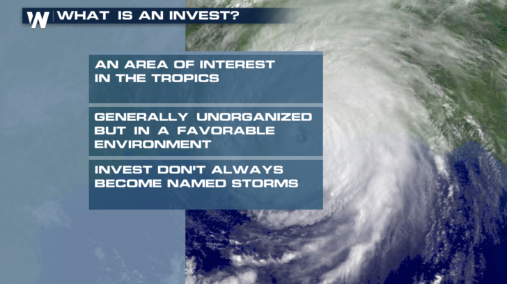
The 2nd area, known as Invest 95-L, is one that should be watched closely over the next week or so. An "invest", or "investigation area" is one that the National Hurricane Center monitors more closely for possible tropical development. Computer models are already being run on Invest 95-L, showing a general westward motion toward the Windward Islands.
 This June was the first since 2014 to have no named storms in the Atlantic basin... a trend many welcome after last years devastating season.
It’s not usually until August when tropical activity really gets going. Typically, the climatological "peak" of season begins in August, lasting through the first week of October. It’s certainly not the time to let your guard down, and perhaps a good time to review your hurricane preparedness plan and make sure you’re ready for the peak months of the tropical season.
This June was the first since 2014 to have no named storms in the Atlantic basin... a trend many welcome after last years devastating season.
It’s not usually until August when tropical activity really gets going. Typically, the climatological "peak" of season begins in August, lasting through the first week of October. It’s certainly not the time to let your guard down, and perhaps a good time to review your hurricane preparedness plan and make sure you’re ready for the peak months of the tropical season.
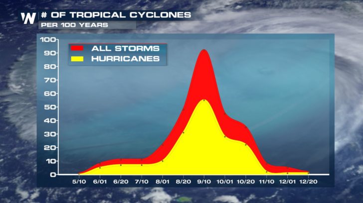 The activity chart for tropical cyclones across the Atlantic during the calendar year between May and December. The peak of the season is during the second week of September.
This June was the first since 2014 to have no named storms in the Atlantic basin... a trend many welcome after last years devastating season.
It’s not usually until August when tropical activity really gets going. Typically, the climatological "peak" of season begins in August, lasting through the first week of October. It’s certainly not the time to let your guard down, and perhaps a good time to review your hurricane preparedness plan and make sure you’re ready for the peak months of the tropical season.
The activity chart for tropical cyclones across the Atlantic during the calendar year between May and December. The peak of the season is during the second week of September.
All Weather News
More
Severe Threat Marches East This Afternoon
UPPER MIDWEST - Through Monday, dangerous tor
28 Jul 2026 4:25 PM

Tropics: Fausto Heads towards Hawaii; Genevieve Cat 4 Hurricane
PacificTropical Storm Fausto continues to tra
28 Jul 2026 4:20 PM


Southeast Flood Risk Lingers Near Stalled Front
A stalled boundary over the Southeast will ke
25 Jul 2026 10:55 AM

Another Round of Storms Targets the Northeast
Tuesday brought severe weather again across p
23 Jul 2026 1:15 AM

Another Round of Severe Weather for the Upper Midwest and Great Lakes
The upper-level low train continues to keep t
21 Jul 2026 1:45 AM