Atlantic Tropics Outlook: Dust Fending Off Storms For Now

Special Stories
19 Jul 2018 7:04 AM
The visible satellite imagery Thursday morning said it all.
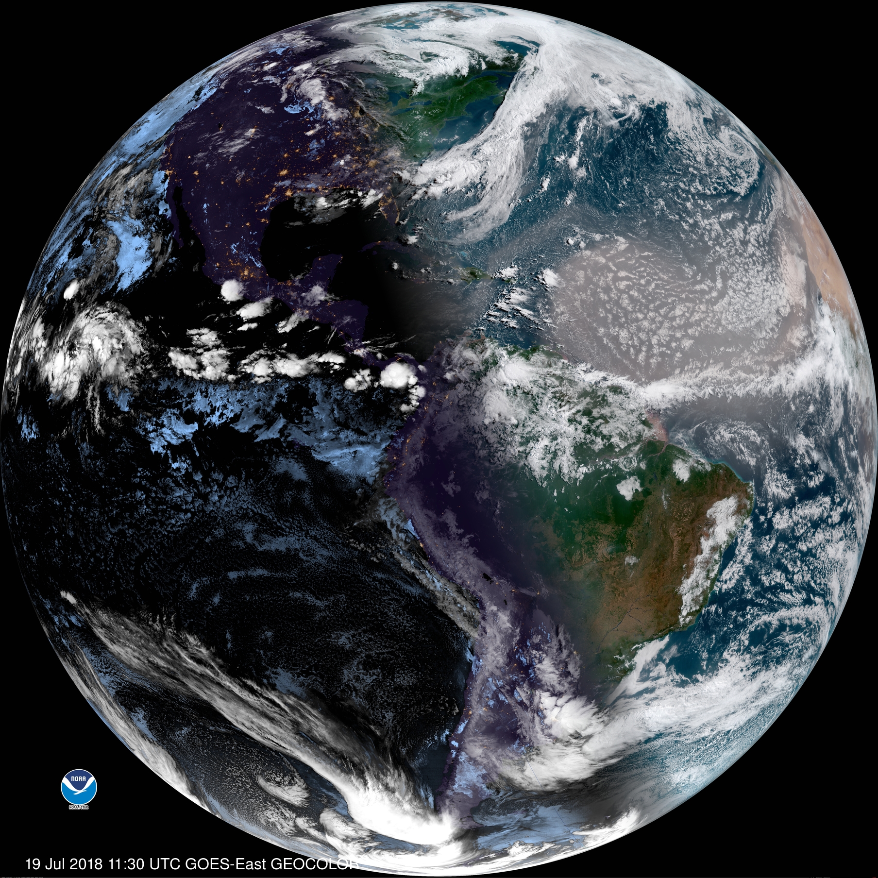 Visible satellite Thursday morning, July 19 courtesy NOAA https://www.star.nesdis.noaa.gov/GOES/index.php
Look closely at the right-hand-side of the picture, toward the middle/top part. If you can see a light brown color, then you see the Saharan Air Layer (SAL for short) crossing much of the central Atlantic Ocean.
Visible satellite Thursday morning, July 19 courtesy NOAA https://www.star.nesdis.noaa.gov/GOES/index.php
Look closely at the right-hand-side of the picture, toward the middle/top part. If you can see a light brown color, then you see the Saharan Air Layer (SAL for short) crossing much of the central Atlantic Ocean.
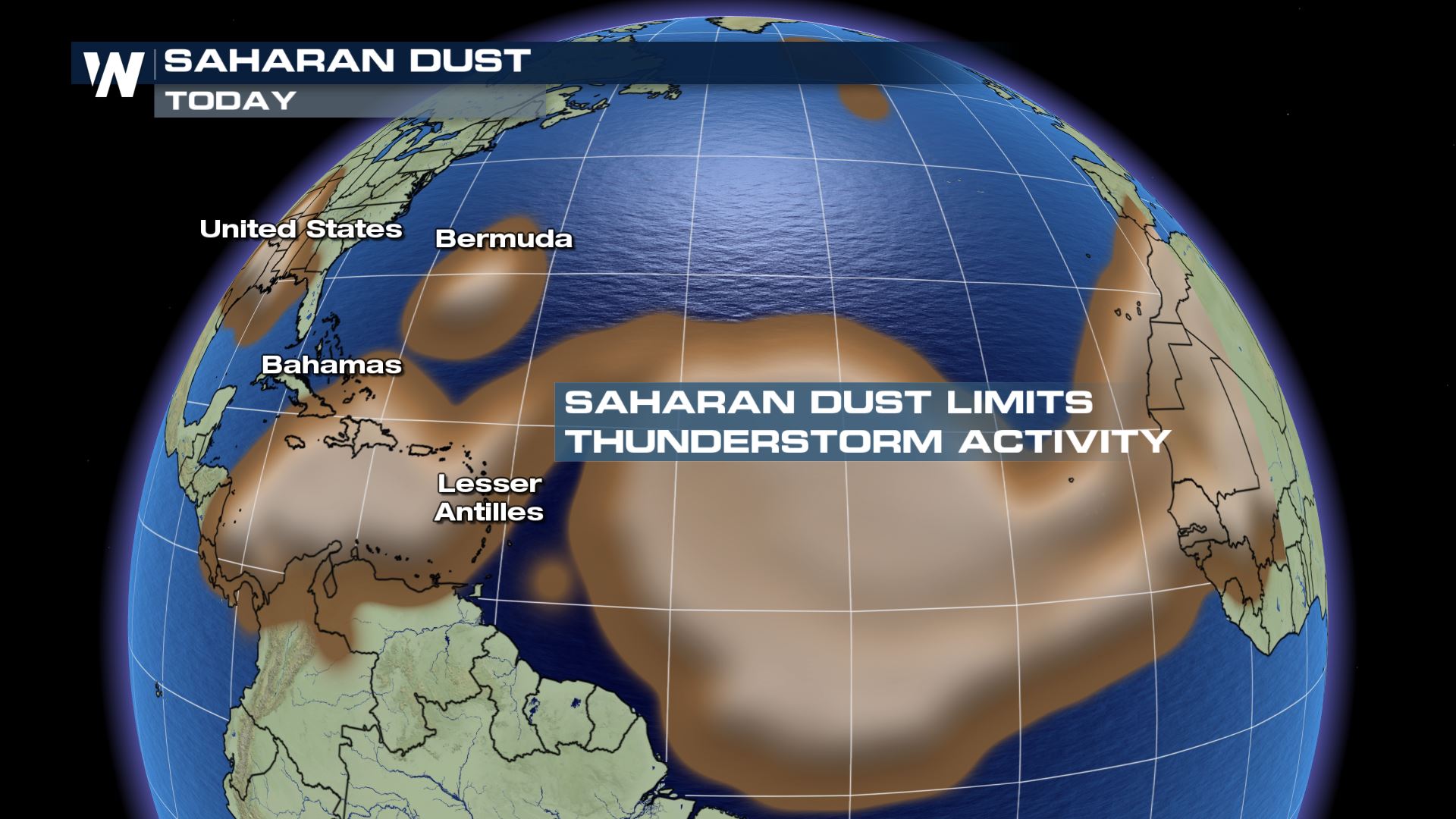 The Saharan Air Layer analysis for Thursday, July 19 where dust aerosols show up in brown.
A rather large plume of the SAL has broken off and moved over the central Atlantic Ocean, thus limiting the thunderstorm activity. When thunderstorm activity is limited, so is the immediate threat of tropical cyclones.
The Saharan Air Layer analysis for Thursday, July 19 where dust aerosols show up in brown.
A rather large plume of the SAL has broken off and moved over the central Atlantic Ocean, thus limiting the thunderstorm activity. When thunderstorm activity is limited, so is the immediate threat of tropical cyclones.
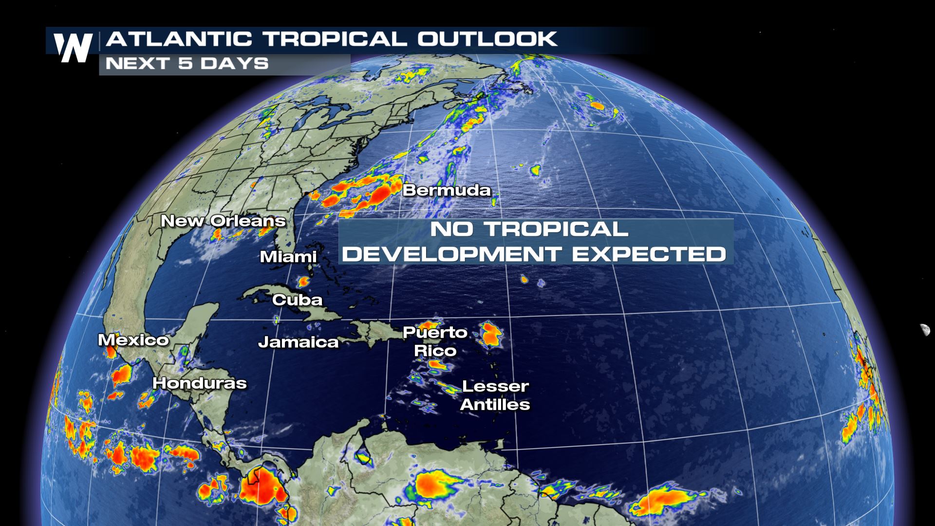 The Atlantic Tropical Outlook from Thursday, July 19 to Monday, July 23
The dust moving across the Atlantic is helping to prevent tropical development in the next five days. In addition, there is also a lot of wind shear in the Caribbean Sea right now to help disrupt tropical systems to develop. Both of these things (dust and wind shear) are day-to-day or weekly factors. That said, a week or two from now could be a different story regarding the weather pattern and potential.
The Atlantic Tropical Outlook from Thursday, July 19 to Monday, July 23
The dust moving across the Atlantic is helping to prevent tropical development in the next five days. In addition, there is also a lot of wind shear in the Caribbean Sea right now to help disrupt tropical systems to develop. Both of these things (dust and wind shear) are day-to-day or weekly factors. That said, a week or two from now could be a different story regarding the weather pattern and potential.
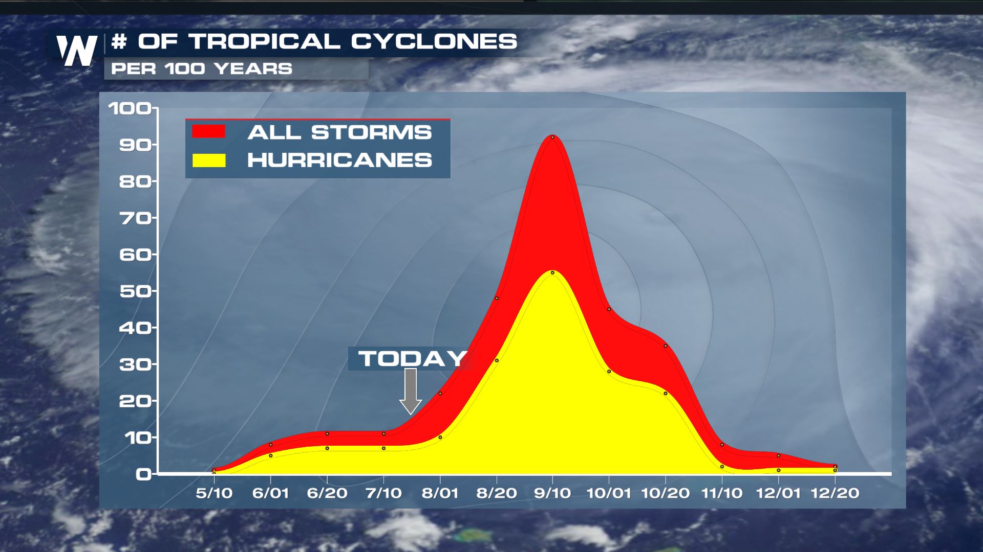 The historical average of the hurricane season where the peak of activity occurs in the second week of September in the Atlantic Basin.
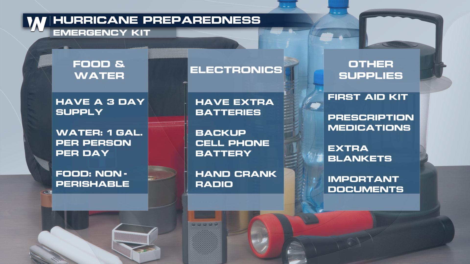
Since it is quiet now, and history tells us July usually stays on the quieter side, it's important to make sure you're prepared for any tropical systems if they were to hit.
The historical average of the hurricane season where the peak of activity occurs in the second week of September in the Atlantic Basin.
Since it is quiet now, and history tells us July usually stays on the quieter side, it's important to make sure you're prepared for any tropical systems if they were to hit.
 Right now, we are closing in on the time last year when things became very active. We are only about three weeks away from when it became busy last year. Take this timetable for a reason why you should make sure you're prepared now!
Visible satellite Thursday morning, July 19 courtesy NOAA https://www.star.nesdis.noaa.gov/GOES/index.php
Look closely at the right-hand-side of the picture, toward the middle/top part. If you can see a light brown color, then you see the Saharan Air Layer (SAL for short) crossing much of the central Atlantic Ocean.
The Saharan Air Layer analysis for Thursday, July 19 where dust aerosols show up in brown.
A rather large plume of the SAL has broken off and moved over the central Atlantic Ocean, thus limiting the thunderstorm activity. When thunderstorm activity is limited, so is the immediate threat of tropical cyclones.
The Atlantic Tropical Outlook from Thursday, July 19 to Monday, July 23
The dust moving across the Atlantic is helping to prevent tropical development in the next five days. In addition, there is also a lot of wind shear in the Caribbean Sea right now to help disrupt tropical systems to develop. Both of these things (dust and wind shear) are day-to-day or weekly factors. That said, a week or two from now could be a different story regarding the weather pattern and potential.
The historical average of the hurricane season where the peak of activity occurs in the second week of September in the Atlantic Basin.
Since it is quiet now, and history tells us July usually stays on the quieter side, it's important to make sure you're prepared for any tropical systems if they were to hit.
Right now, we are closing in on the time last year when things became very active. We are only about three weeks away from when it became busy last year. Take this timetable for a reason why you should make sure you're prepared now!
- August 13, 2017: Tropical Storm Gert formed in the western Atlantic
- Hurricane Harvey occurred
- Hurricane Irma occurred
- Hurricane Jose occurred
- Hurricane Katia occurred
- Hurricane Lee occurred
- Hurricane Maria occured
- September 30, 2017: Hurricanes Lee and Maria dissipated
All Weather News
More
Fronts Continue To Spark Severe Weather Across the Plains
A cold front that brought record lows to the
18 Jul 2025 10:40 PM

Extreme Heat Impacts for the East Coast & South
Extreme heat continues to impact several area
18 Jul 2025 10:05 PM

Flooding Threat Remains Elevated in the East
A cold front pushing through the Eastern Seab
18 Jul 2025 9:10 PM

EF-2 Firenado from the Deer Creek Fire in Utah
A fire tornado was spotted near La Sal, Utah
18 Jul 2025 7:30 AM

Tropical System Brings Flood Risk to the Central Gulf
Time has run out for notable tropical develop
18 Jul 2025 3:05 AM

Heavy Rain, Flooding Threat Returns to Florida
Keep the rain boots handy in Florida - heavy
13 Jul 2025 12:50 PM

Severe Storm Risk Pushes into the Great Lakes, Ohio Valley
Friday was another busy day with severe weath
12 Jul 2025 8:00 PM