Atmospheric Rivers Eradicate All of California's Extreme Drought Conditions
Top Stories
30 Jan 2023 10:00 AM
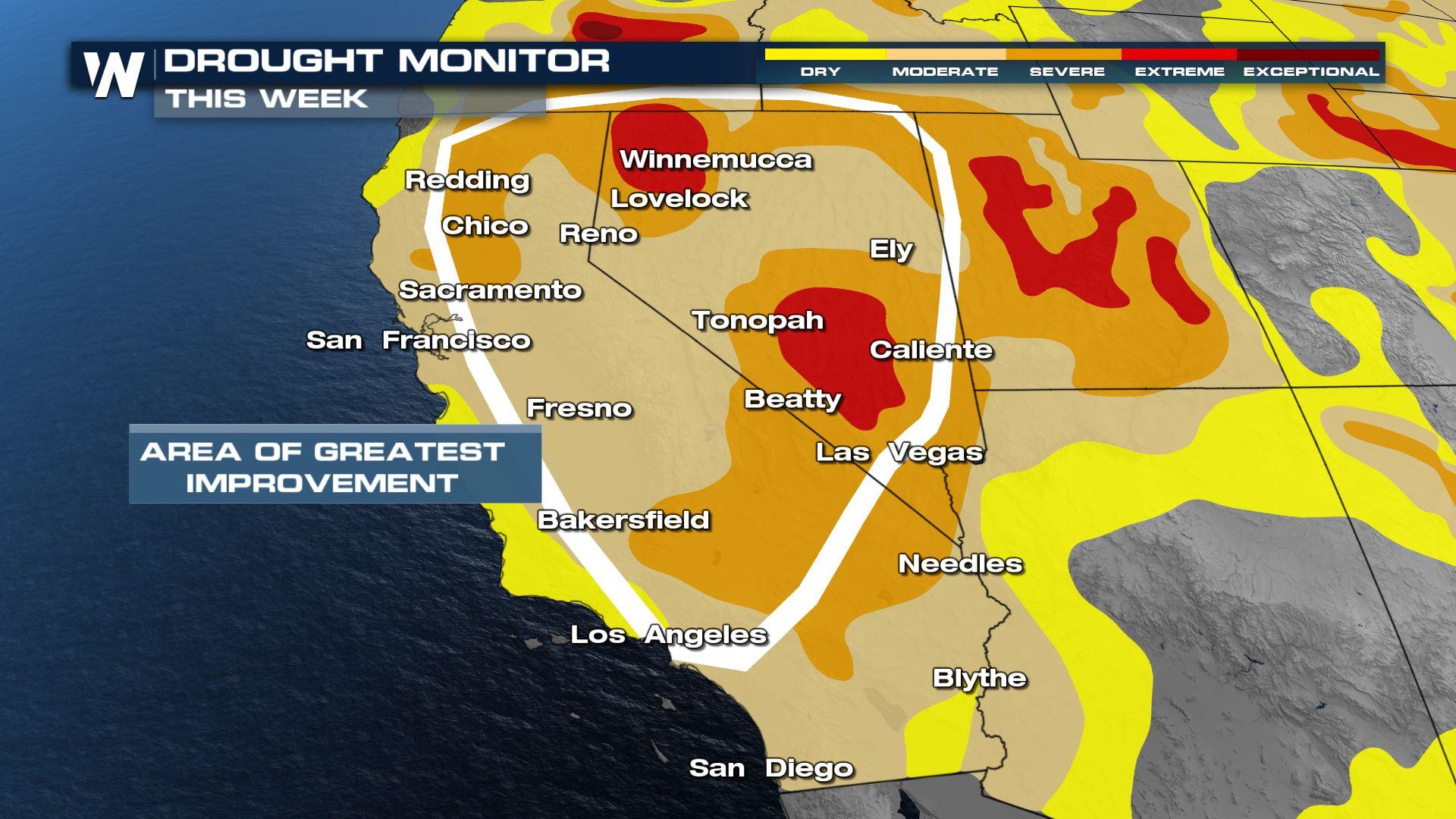
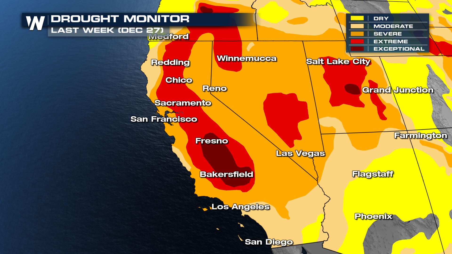
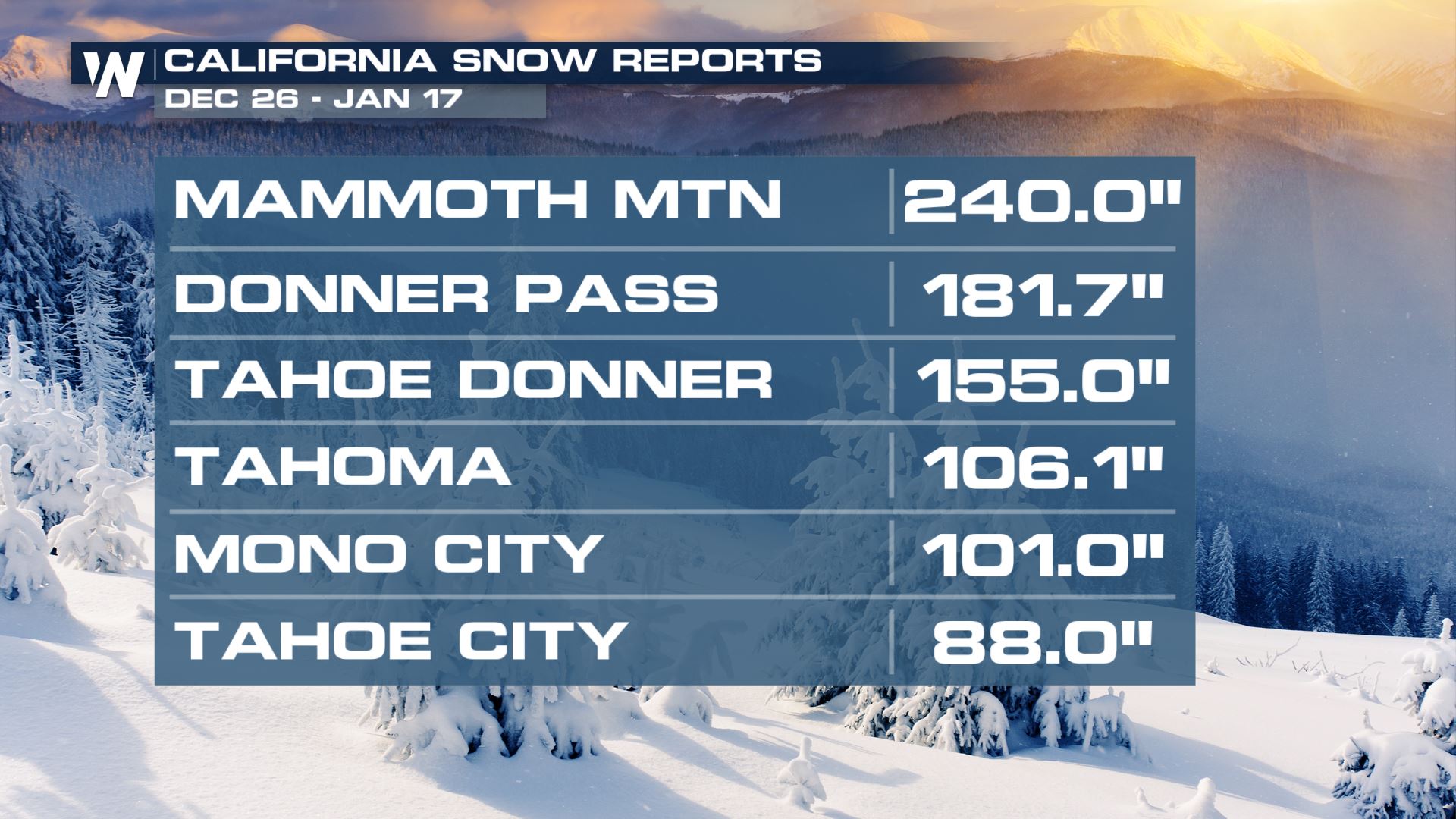
From December 26, 2022 to January 17, 2023 9 individual atmospheric rivers (ARs) impacted California and the western U.S. with tremendous amounts of rain and snow. These ARs have worked to increase California's snowpack and water resources of 80% of a full seasonal snowpack. According to NIDIS, "Statewide, precipitation over these 3 weeks was 11.2 inches, which is 46% of a full water year". As a result of the heavy rain and snowfall, drought has been significantly improved through California specifically. A three week difference in the drought monitor shows no extreme or exceptional drought in California, a vast improvement. However, the drought we are dealing with is a "long term drought" meaning reservoirs, soils and groundwater are very low, and it will take months if not years of consistent moisture to eradicate all of the West's drought. There are still areas of extreme and exceptional drought (the two highest categories) through Utah, Nevada and Oregon. Exceptional drought is the highest level of drought (5 on a scale of 1 to 5) and is characterized by "Exceptional and widespread crop and pasture losses, exceptional fire risk, shortages of water in reservoirs, streams and wells causing water emergencies." according to the National Weather Service. It is important to note that 100% of the state of California is still feeling some sort of drought conditions.
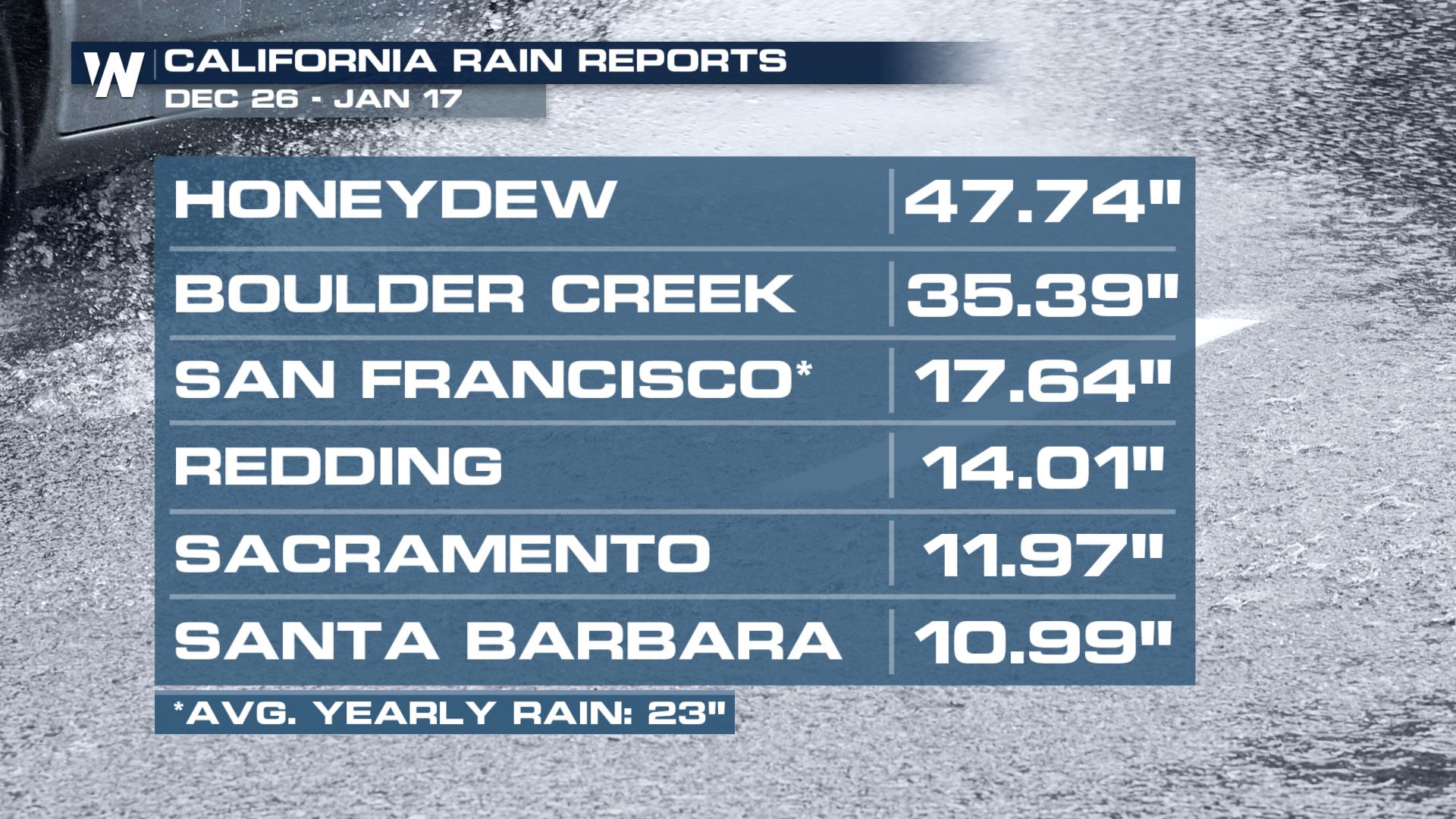
 This is all thanks to tremendous amounts of rain and snow, since December 26th, when the first potent atmospheric river began. Some spots saw nearly 4 feet of rain in just over 3 weeks. San Francisco saw 75% of their yearly rainfall within the first two weeks of January. And while the rain has been wonderful at combating the ongoing severe drought in the state, which is still facing water restrictions, all the moisture at once caused flood problems. Urban and flash flooding lead to evacuations of communities near recent burn scars and along the coastline where mudslides and debris flows are possible. Reservoirs are still below where they should be for this time of year - so consistent moisture through the Spring is key to building up the deficits.
 Speaking of the difference in reservoirs, check out the drone footage from our field correspondent Brandon Clement of the 18 months of difference in water levels. Most of the water rise is a result of the heavy rain and snow in the past month!
https://twitter.com/WeatherNation/status/1616193797024632832
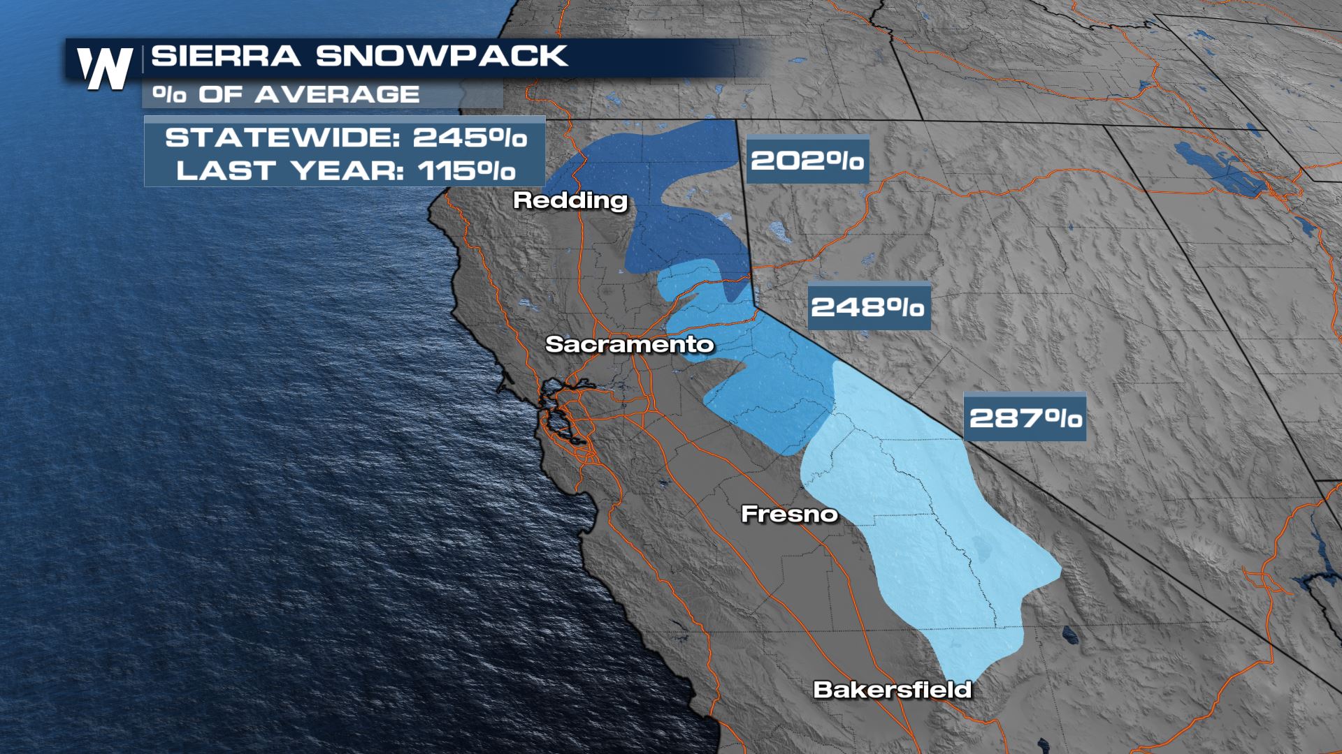
The Southern Sierra has 2.5x the amount of average snowfall for this time of year. Statewide we are at 215% of normal for this time of year and already over the percent of snowpack we need by April 1st to fill reservoirs. The heavy snowfall can stress the pack, leading to the avalanche danger in the High Country. We are still relatively early in the water season, and if we end up with a drier February - April our water year could be moderate as opposed to "high" if the season continues in the wet pattern according to NIDIS. Long term NOAA CPC Seasonal Outlooks indicate the potential of drought removal or improvement in the west but specifics on how much rain/snow and when is still uncertain.
Speaking of the difference in reservoirs, check out the drone footage from our field correspondent Brandon Clement of the 18 months of difference in water levels. Most of the water rise is a result of the heavy rain and snow in the past month!
https://twitter.com/WeatherNation/status/1616193797024632832
The Southern Sierra has 2.5x the amount of average snowfall for this time of year. Statewide we are at 215% of normal for this time of year and already over the percent of snowpack we need by April 1st to fill reservoirs. The heavy snowfall can stress the pack, leading to the avalanche danger in the High Country. We are still relatively early in the water season, and if we end up with a drier February - April our water year could be moderate as opposed to "high" if the season continues in the wet pattern according to NIDIS. Long term NOAA CPC Seasonal Outlooks indicate the potential of drought removal or improvement in the west but specifics on how much rain/snow and when is still uncertain.
 For more on the wet weather in the west and damage as a result of multiple storm systems, join WeatherNation for your top weather headlines and Western Regional Forecast at :50 past the hour.
This is all thanks to tremendous amounts of rain and snow, since December 26th, when the first potent atmospheric river began. Some spots saw nearly 4 feet of rain in just over 3 weeks. San Francisco saw 75% of their yearly rainfall within the first two weeks of January. And while the rain has been wonderful at combating the ongoing severe drought in the state, which is still facing water restrictions, all the moisture at once caused flood problems. Urban and flash flooding lead to evacuations of communities near recent burn scars and along the coastline where mudslides and debris flows are possible. Reservoirs are still below where they should be for this time of year - so consistent moisture through the Spring is key to building up the deficits.
Speaking of the difference in reservoirs, check out the drone footage from our field correspondent Brandon Clement of the 18 months of difference in water levels. Most of the water rise is a result of the heavy rain and snow in the past month!
https://twitter.com/WeatherNation/status/1616193797024632832
The Southern Sierra has 2.5x the amount of average snowfall for this time of year. Statewide we are at 215% of normal for this time of year and already over the percent of snowpack we need by April 1st to fill reservoirs. The heavy snowfall can stress the pack, leading to the avalanche danger in the High Country. We are still relatively early in the water season, and if we end up with a drier February - April our water year could be moderate as opposed to "high" if the season continues in the wet pattern according to NIDIS. Long term NOAA CPC Seasonal Outlooks indicate the potential of drought removal or improvement in the west but specifics on how much rain/snow and when is still uncertain.
For more on the wet weather in the west and damage as a result of multiple storm systems, join WeatherNation for your top weather headlines and Western Regional Forecast at :50 past the hour.All Weather News
More


More Storms for the East Through Monday
A low-pressure system that moved through the
3 Aug 2026 1:50 AM

After Reaching Category 5, Genevieve Weakens in the Pacific
PacificGenevieve formed last Friday south of
3 Aug 2026 12:30 AM

Flooding, Severe Storms Target the Midwest Again
After an active week of storms across the nor
1 Aug 2026 1:40 AM

Flooding Risk Increases as Heavy Rain Targets the Tri-State Area
Tuesday, heavy rainfall moved across the Nort
30 Jul 2026 12:25 AM

Severe Weather: Energy From the Midwest Now in the Southeast
UPPER MIDWEST - Through Monday, dangerous tor
29 Jul 2026 10:30 PM