Autumn Recap - Third Warmest on Record

Special Stories
20 Dec 2021 1:00 AM
[Flooding in Bellingham, WA during the middle of November. From the City of Bellingham via Storyful]
[From NOAA and NOAA NCEI] The numbers have been crunched for the past few months and the year so far. Here's the latest climate information from this past fall and the year-to-date.
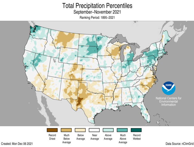
 The total autumn precipitation was 6.81 inches (0.07 of an inch below average), which ranked in the middle third of the seasonal record. Precipitation was above average across parts of the West, northern Plains, Ohio Valley, Northeast and Southeast. Washington state ranked sixth wettest for this three-month period. Precipitation was below average across portions of the Southwest, northern Rockies, central to southern Rockies, southern Plains, Lower Mississippi River Valley, western Great Lakes and the Carolinas and Virginia.
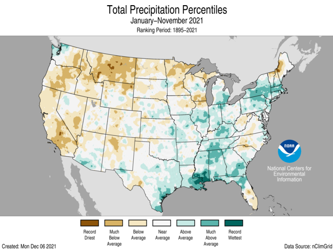
 Despite the drier-than-normal autumn, the U.S. continued a wet YTD, with a precipitation total of 28.06 inches (0.47 of an inch above average), ranking in the middle-third of the climate record. January-November precipitation was above average from the Gulf Coast to the Great Lakes and into portions of the Northeast. Mississippi ranked eighth wettest on record. Precipitation was below average across much of the West, northern Plains and portions of New England and the Carolinas. Montana ranked fourth driest on record for this January-November period.

Meteorological Autumn (September, October, November)
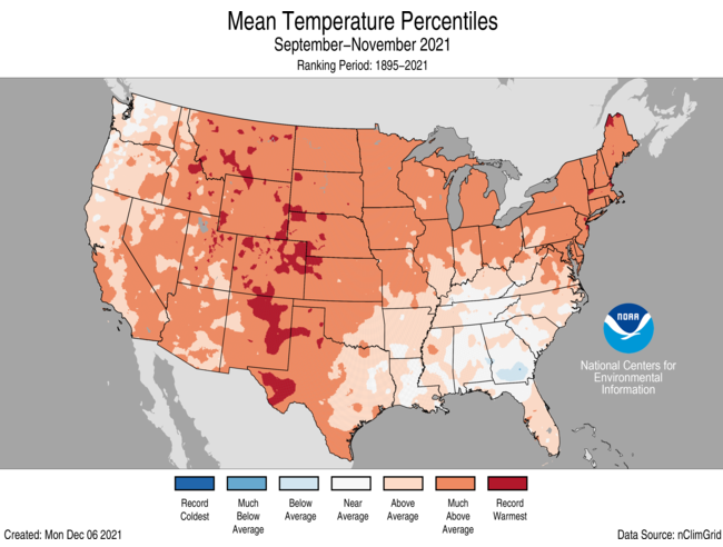
It was a warm meteorological autumn (September through November) across the contiguous U.S. The average autumn temperature was 56.7 degrees F (3.1 degrees above average), making it the third-warmest meteorological autumn in the historical record. Colorado, Montana, and Wyoming ranked second warmest, with 14 additional states ranking among their five warmest autumns.
The total autumn precipitation was 6.81 inches (0.07 of an inch below average), which ranked in the middle third of the seasonal record. Precipitation was above average across parts of the West, northern Plains, Ohio Valley, Northeast and Southeast. Washington state ranked sixth wettest for this three-month period. Precipitation was below average across portions of the Southwest, northern Rockies, central to southern Rockies, southern Plains, Lower Mississippi River Valley, western Great Lakes and the Carolinas and Virginia.
Year-to-date (January-November)
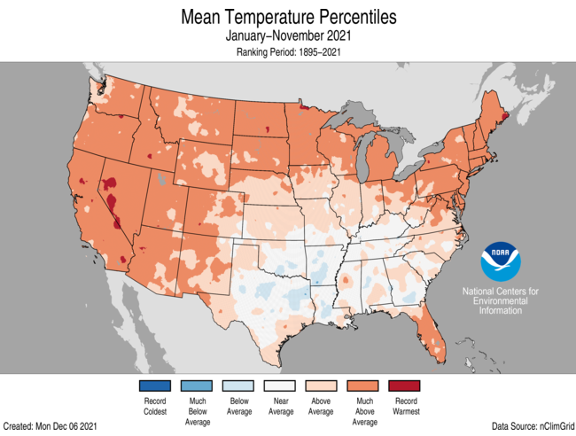
With just one month left in 2021, the year to date (YTD, January through November) is the seventh-warmest on record — with an average temperature of 55.9 degrees F (2.1 degrees above average). Year-to-date temperatures were above average across the western U.S., central and northern Plains, Great Lakes and East Coast with Maine ranking second warmest and 11 additional states across the Northeast, Great Lakes, northern Plains and West ranking among their five warmest such periods. Temperatures were near average across portions of the southern Plains, central Gulf Coast and Tennessee Valley with pockets of below-average temperatures embedded across the South.
Despite the drier-than-normal autumn, the U.S. continued a wet YTD, with a precipitation total of 28.06 inches (0.47 of an inch above average), ranking in the middle-third of the climate record. January-November precipitation was above average from the Gulf Coast to the Great Lakes and into portions of the Northeast. Mississippi ranked eighth wettest on record. Precipitation was below average across much of the West, northern Plains and portions of New England and the Carolinas. Montana ranked fourth driest on record for this January-November period.
All Weather News
More
Fronts Continue To Spark Severe Weather Across the Plains
A cold front that brought record lows to the
18 Jul 2025 10:40 PM

Extreme Heat Impacts for the East Coast & South
Extreme heat continues to impact several area
18 Jul 2025 10:05 PM

Flooding Threat Remains Elevated in the East
A cold front pushing through the Eastern Seab
18 Jul 2025 9:10 PM

EF-2 Firenado from the Deer Creek Fire in Utah
A fire tornado was spotted near La Sal, Utah
18 Jul 2025 7:30 AM

Tropical System Brings Flood Risk to the Central Gulf
Time has run out for notable tropical develop
18 Jul 2025 3:05 AM

Heavy Rain, Flooding Threat Returns to Florida
Keep the rain boots handy in Florida - heavy
13 Jul 2025 12:50 PM

Severe Storm Risk Pushes into the Great Lakes, Ohio Valley
Friday was another busy day with severe weath
12 Jul 2025 8:00 PM