Bone-Chilling Cold in the Northeast

Special Stories
14 Feb 2020 10:00 AM
Many Northeast cities will likely feel their coldest air of the winter season (so far) on Saturday morning! Air temperatures will fall well below zero in northern New England, while larger cities in the Mid-Atlantic area will dip into the teens and single digits.
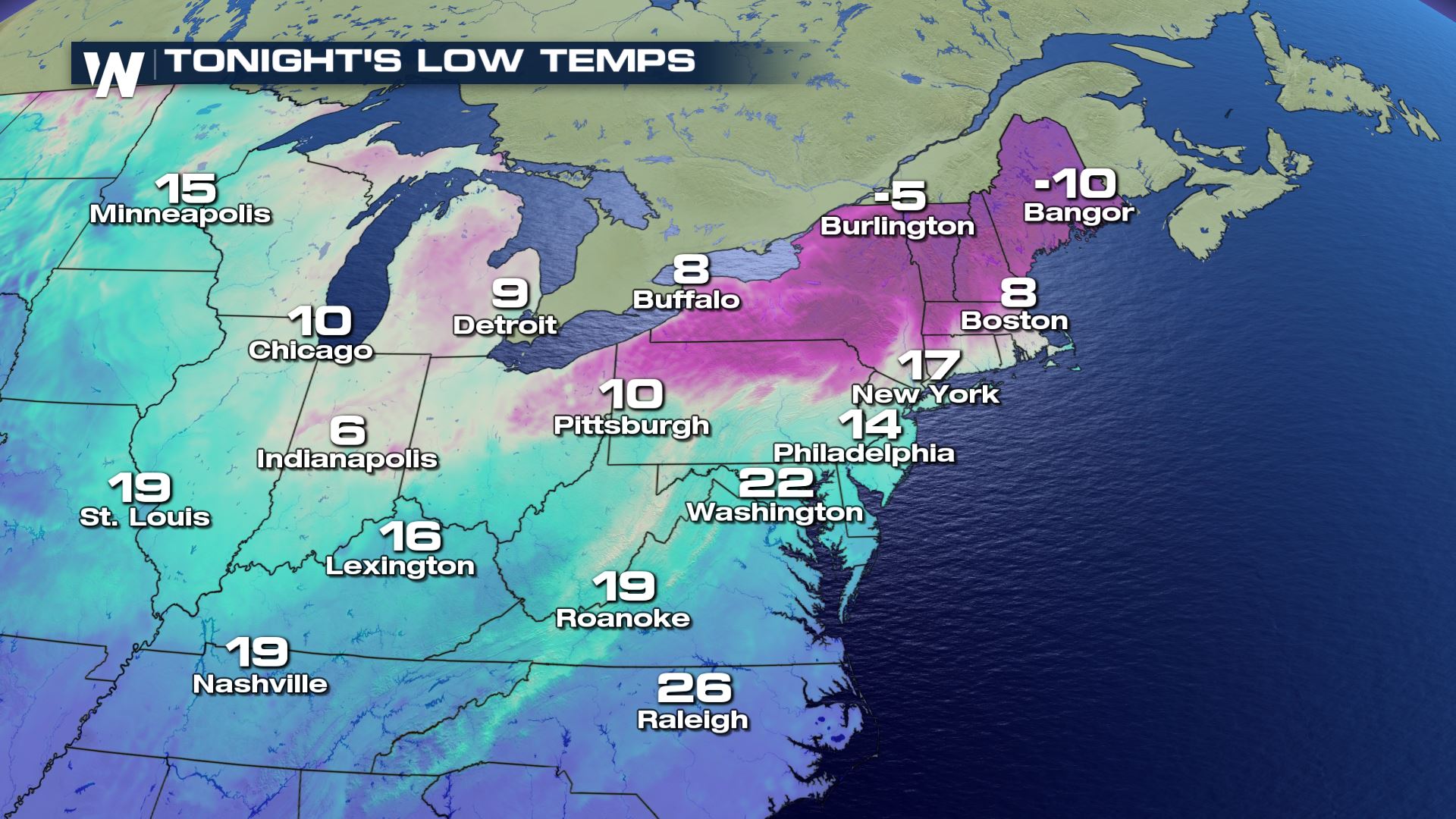 Low temperature forecast Saturday morning, February 15
If the forecast pans out as expected, these morning low temperatures will likely be the coldest of the season to this point! Many cities near the Interstate 95 corridor have had a very mild winter with little to no snowfall, but Saturday morning will feel much more wintry.
Low temperature forecast Saturday morning, February 15
If the forecast pans out as expected, these morning low temperatures will likely be the coldest of the season to this point! Many cities near the Interstate 95 corridor have had a very mild winter with little to no snowfall, but Saturday morning will feel much more wintry.
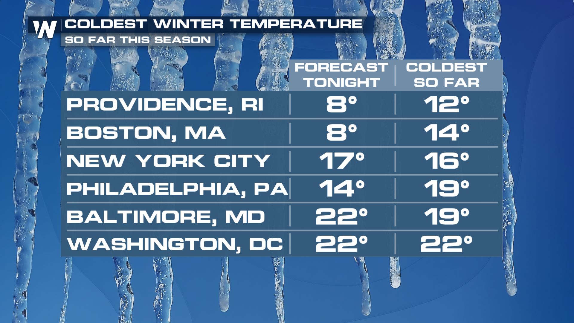 Forecast low temperature Saturday morning in the left column, compared to the coldest temperature of the winter season so far (right column)
A strong cold front pushed through the Northeast Friday, bringing these colder temperatures. High pressure will build in Saturday and provide a clear sky, but will also bring breezy winds with it. When the wind is factored in, the wind chill will be in the teens to twenties *below* zero!
Forecast low temperature Saturday morning in the left column, compared to the coldest temperature of the winter season so far (right column)
A strong cold front pushed through the Northeast Friday, bringing these colder temperatures. High pressure will build in Saturday and provide a clear sky, but will also bring breezy winds with it. When the wind is factored in, the wind chill will be in the teens to twenties *below* zero!
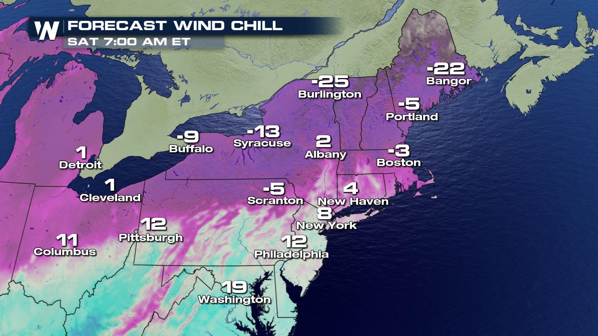 Forecast wind chill values on Saturday morning, February 15 (in Fahrenheit)
The cold weather will be short-lived as temperatures are expected to rebound quite quickly by Sunday.
Forecast wind chill values on Saturday morning, February 15 (in Fahrenheit)
The cold weather will be short-lived as temperatures are expected to rebound quite quickly by Sunday.
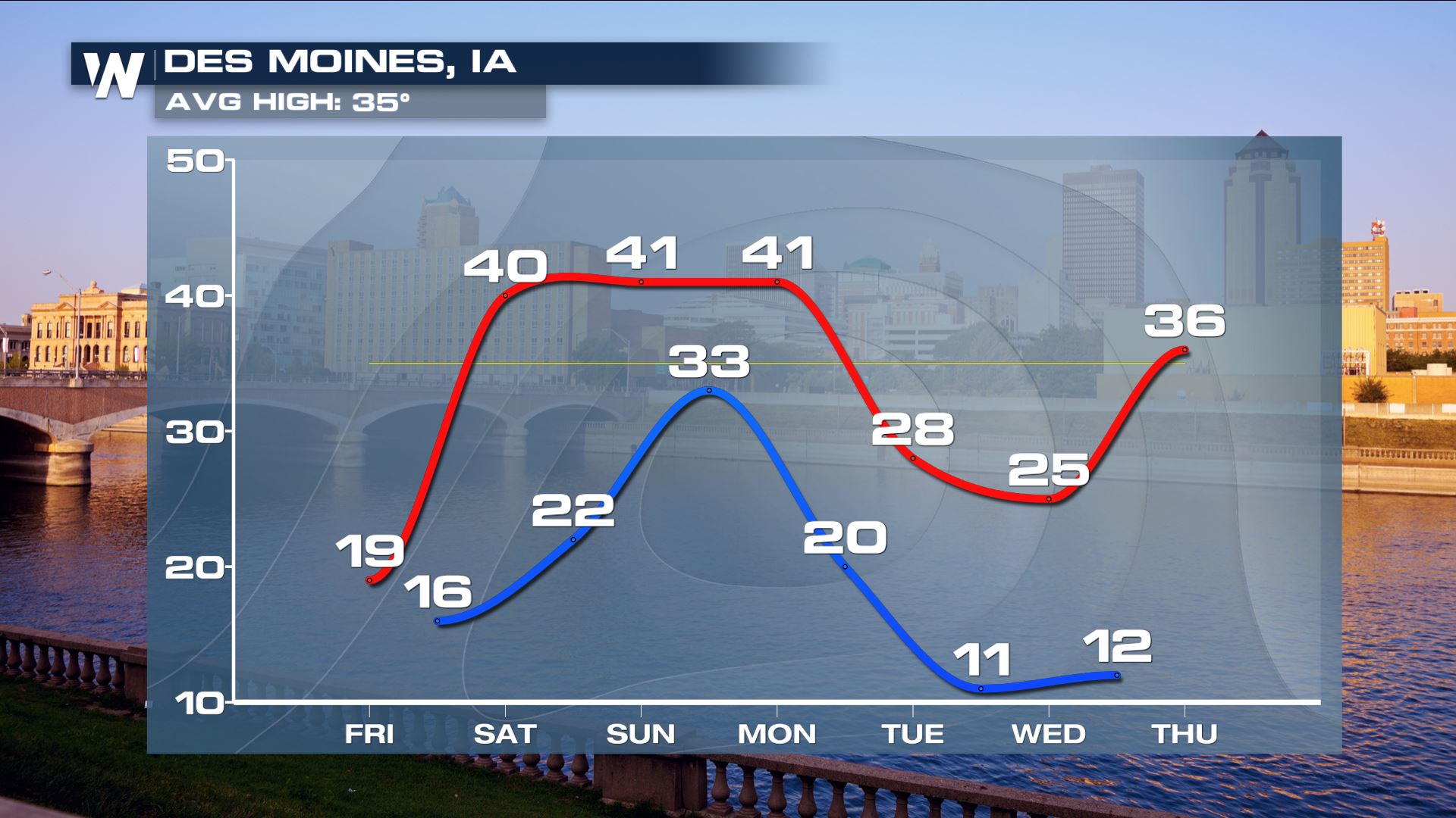
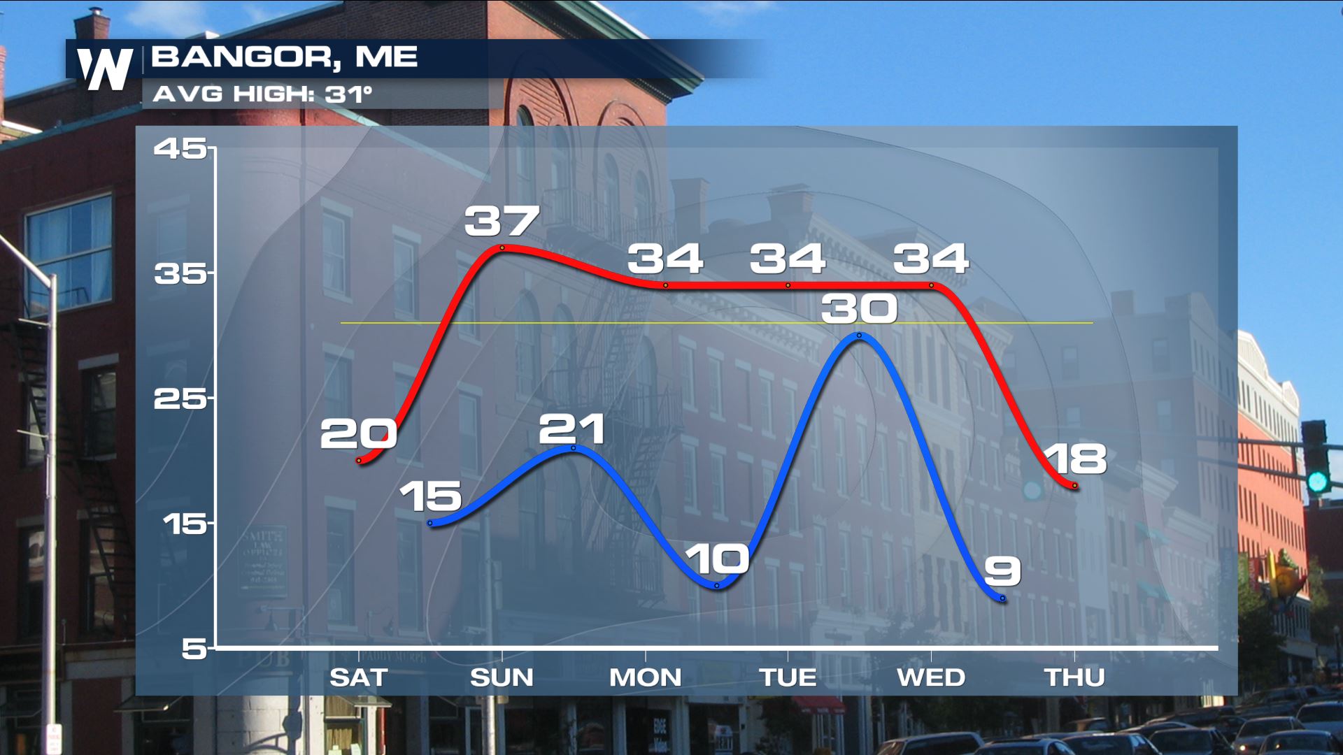 High (red) and low temperature forecast (blue) from Saturday to Thursday, February 15-20
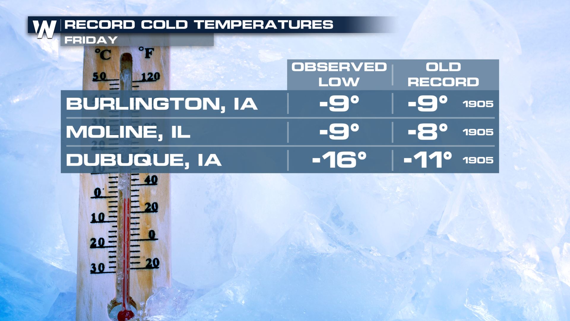
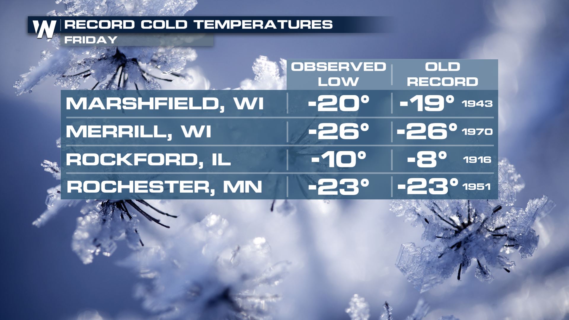
This cold air mass came from the Midwest and High Plains where it brought record cold temperatures on Friday morning.
High (red) and low temperature forecast (blue) from Saturday to Thursday, February 15-20
This cold air mass came from the Midwest and High Plains where it brought record cold temperatures on Friday morning.
 These locations are also warming up right now and will likely have much higher temperatures Saturday and Sunday afternoon.
 High (red) and low temperature forecast (blue) from Saturday to Thursday, February 15-20
Join us live on-air for coverage of the frigid temperatures and snow.
High (red) and low temperature forecast (blue) from Saturday to Thursday, February 15-20
Join us live on-air for coverage of the frigid temperatures and snow.
Low temperature forecast Saturday morning, February 15
If the forecast pans out as expected, these morning low temperatures will likely be the coldest of the season to this point! Many cities near the Interstate 95 corridor have had a very mild winter with little to no snowfall, but Saturday morning will feel much more wintry.
Forecast low temperature Saturday morning in the left column, compared to the coldest temperature of the winter season so far (right column)
A strong cold front pushed through the Northeast Friday, bringing these colder temperatures. High pressure will build in Saturday and provide a clear sky, but will also bring breezy winds with it. When the wind is factored in, the wind chill will be in the teens to twenties *below* zero!
Forecast wind chill values on Saturday morning, February 15 (in Fahrenheit)
The cold weather will be short-lived as temperatures are expected to rebound quite quickly by Sunday.
High (red) and low temperature forecast (blue) from Saturday to Thursday, February 15-20
This cold air mass came from the Midwest and High Plains where it brought record cold temperatures on Friday morning.
These locations are also warming up right now and will likely have much higher temperatures Saturday and Sunday afternoon.
High (red) and low temperature forecast (blue) from Saturday to Thursday, February 15-20
Join us live on-air for coverage of the frigid temperatures and snow.All Weather News
More
Tropics: Fausto Heads towards Hawaii; Genevieve Cat 4 Hurricane
PacificHurricane Fausto continues to track we
27 Jul 2026 11:00 PM

Severe Storms Target the Midwest to the Northeast
UPPER MIDWEST - Dangerous tornadoes have alre
27 Jul 2026 10:20 PM


Southeast Flood Risk Lingers Near Stalled Front
A stalled boundary over the Southeast will ke
25 Jul 2026 10:55 AM

Another Round of Storms Targets the Northeast
Tuesday brought severe weather again across p
23 Jul 2026 1:15 AM

Another Round of Severe Weather for the Upper Midwest and Great Lakes
The upper-level low train continues to keep t
21 Jul 2026 1:45 AM