Boston Blizzard: Schools Closed, Snow Emergency
Top Stories
12 Mar 2018 2:34 PM
Another week, another March nor'easter set to deliver huge impacts to one city in particular.
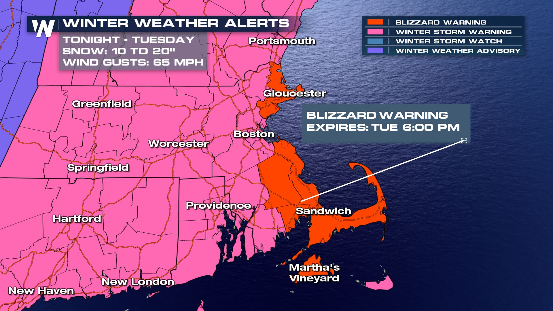
Boston, Massachusetts is under a Winter Storm Warning, with high winds and major snow is expected on Tuesday and lasting into early Wednesday.
First, the forecast: Snow accumulations are expected to total 10 to 18 inches in metro Boston, with some locally higher amounts possible. This will be combined with winds up to 65 miles-per-hour (MPH) in the area, leading to high drifting and blowing of snow. The snow will taper down to light snow showers on Tuesday night, with leftover snow showers through much of Wednesday, although the main accumulations are expected on Tuesday.
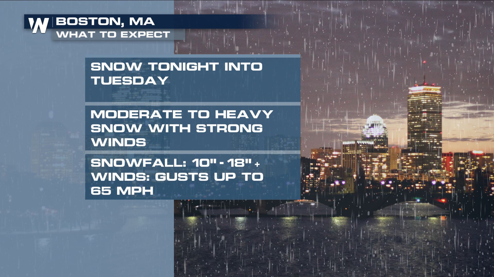 Winds and coastal flooding will both also be major hazards, as blizzard warnings are in place for Cape Ann and Cape Cod, just outside of Boston. Boston Public Schools are closed on Tuesday as well.
 A parking ban is in effect for the city starting Monday night at 7pm ET. Free and discounted parking at city garages will be available, according to the Mayor of Boston, Marty Walsh. Boston's Logan Airport is bracing for widespread cancellations on Tuesday and Wednesday, and airlines are lifting change fees for anyone trying to get out before the storm begins.
Boston's largest snow event this winter was a 13.4" snow on January 4th, and this storm could easily top that. With 42.3" of snow so far this winter, this storm will almost certainly push Boston's seasonal total above the seasonable average of 43.8".
Stay with WeatherNation for the latest.
For WeatherNation: Meteorologist Chris Bianchi
A parking ban is in effect for the city starting Monday night at 7pm ET. Free and discounted parking at city garages will be available, according to the Mayor of Boston, Marty Walsh. Boston's Logan Airport is bracing for widespread cancellations on Tuesday and Wednesday, and airlines are lifting change fees for anyone trying to get out before the storm begins.
Boston's largest snow event this winter was a 13.4" snow on January 4th, and this storm could easily top that. With 42.3" of snow so far this winter, this storm will almost certainly push Boston's seasonal total above the seasonable average of 43.8".
Stay with WeatherNation for the latest.
For WeatherNation: Meteorologist Chris Bianchi
Winds and coastal flooding will both also be major hazards, as blizzard warnings are in place for Cape Ann and Cape Cod, just outside of Boston. Boston Public Schools are closed on Tuesday as well.
A parking ban is in effect for the city starting Monday night at 7pm ET. Free and discounted parking at city garages will be available, according to the Mayor of Boston, Marty Walsh. Boston's Logan Airport is bracing for widespread cancellations on Tuesday and Wednesday, and airlines are lifting change fees for anyone trying to get out before the storm begins.
Boston's largest snow event this winter was a 13.4" snow on January 4th, and this storm could easily top that. With 42.3" of snow so far this winter, this storm will almost certainly push Boston's seasonal total above the seasonable average of 43.8".
Stay with WeatherNation for the latest.
For WeatherNation: Meteorologist Chris BianchiAll Weather News
More


More Storms for the East Sunday and Monday
A low-pressure system crashing through the Mi
2 Aug 2026 2:20 AM

After Reaching Category 5, Genevieve Weakens in the Pacific
PacificGenevieve formed on last Friday south
2 Aug 2026 1:30 AM

Flooding, Severe Storms Target the Midwest Again
After an active week of storms across the nor
1 Aug 2026 1:40 AM

Flooding Risk Increases as Heavy Rain Targets the Tri-State Area
Tuesday, heavy rainfall moved across the Nort
30 Jul 2026 12:25 AM

Severe Weather: Energy From the Midwest Now in the Southeast
UPPER MIDWEST - Through Monday, dangerous tor
29 Jul 2026 10:30 PM