BREAKING: Barry Makes Landfall in Louisiana
Special Stories
13 Jul 2019 11:56 AM
Tropical Storm Barry has made landfall in Louisiana near Intracoastal City, Louisiana - south of Lafayette- according to the latest information from the National Hurricane Center.
Barry's landfall wasa *very* slow process, due to the slow movement of the storm. It officially was noted as having made landfall as of the 1pm CT update from the National Hurricane Center. Barry was a low end category 1 hurricane with winds near 75 mph.
It quickly was downgraded just inland to a tropical storm with maximum winds down to 70 mph and a central pressure of 996 mb.
Before landfall, Barry made a big impact on the shores of the Gulf Coast, with high winds, storm surge, and burst of rain, but the worst may be yet to come with Barry.
https://www.facebook.com/WeatherNation/videos/366037323955990/
As Barry slowly moves inland this weekend, it will bring torrential rainfall for parts of Louisiana, Mississippi, and neighboring states to the north. Rainfall totals will push upwards of 10-20" in some locations of Louisiana, enough to cause major flooding. There is great concern for many major rivers to swell to exacerbate flooding for several days or even weeks.
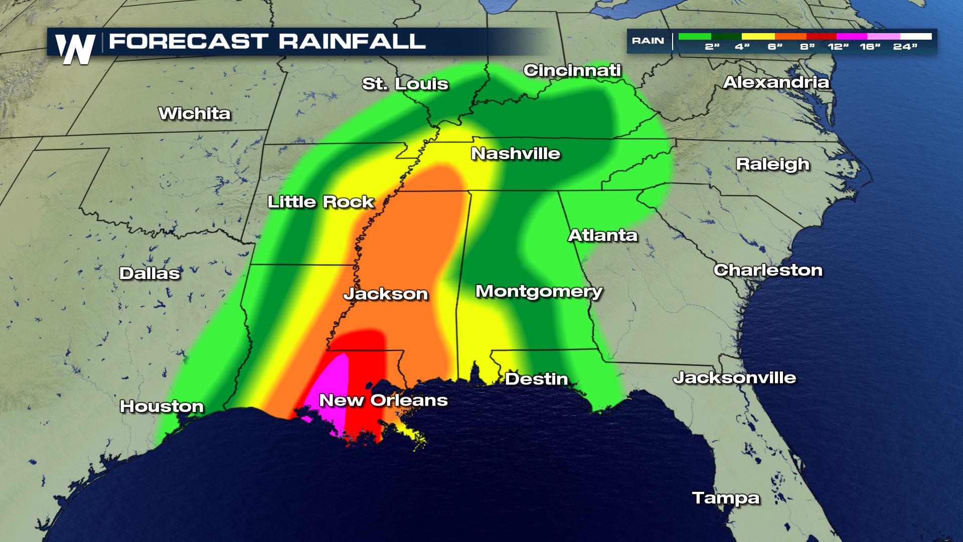 A state of emergency remains for Louisiana and Mississippi in anticipation of the expected impacts from Barry.
The inland threats can sometimes be as impactful, or more so as tropical systems hit. The threat of tornadoes, and severe flooding are the greatest threats. WATCH:
https://www.youtube.com/watch?v=FBKLFsUUMyk
Stay with WeatherNation as we continue to follow this developing story. Follow us on Twitter or Facebook for updates
A state of emergency remains for Louisiana and Mississippi in anticipation of the expected impacts from Barry.
The inland threats can sometimes be as impactful, or more so as tropical systems hit. The threat of tornadoes, and severe flooding are the greatest threats. WATCH:
https://www.youtube.com/watch?v=FBKLFsUUMyk
Stay with WeatherNation as we continue to follow this developing story. Follow us on Twitter or Facebook for updates
All Weather News
More

Flooding, Severe Storms Target the Midwest Again
After an active week of storms across the nor
1 Aug 2026 1:40 AM


After Reaching Category 5, Genevieve Weakens in the Pacific
PacificFausto is now a post-tropical cyclone.
31 Jul 2026 1:30 AM

Flooding Risk Increases as Heavy Rain Targets the Tri-State Area
Tuesday, heavy rainfall moved across the Nort
30 Jul 2026 12:25 AM

Severe Weather: Energy From the Midwest Now in the Southeast
UPPER MIDWEST - Through Monday, dangerous tor
29 Jul 2026 10:30 PM