In early 2017, California was coming out of a historic drought that lasted for five years. Heavy rainfall during the wet season filled California's reservoirs. But a big factor in drought recovery, was the snowfall during the winter of 2016-2017. Last winter, an abundance of snow fell across the Sierra Nevada. But this year, it's a very different story. Snowpack is well below average.
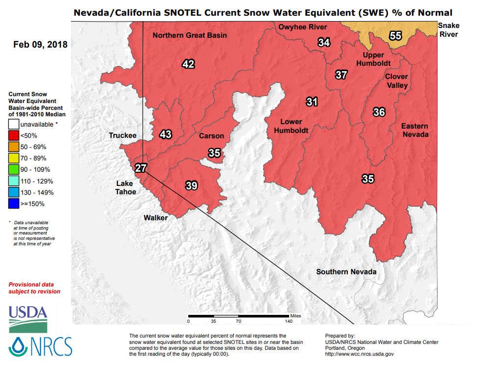
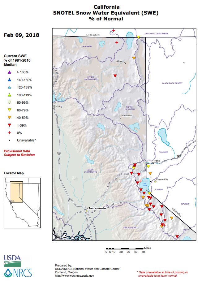
Checking out the numbers in the two images below, most of the Sierra Nevada snow levels are running below 40% of normal. Snow water equivalent values in Lake Tahoe are only 27% of normal.
California Snow Totals Are Way Down This Year, After Drought Breaking Snowfall in 2017.
Special Stories
9 Feb 2018 5:42 PM
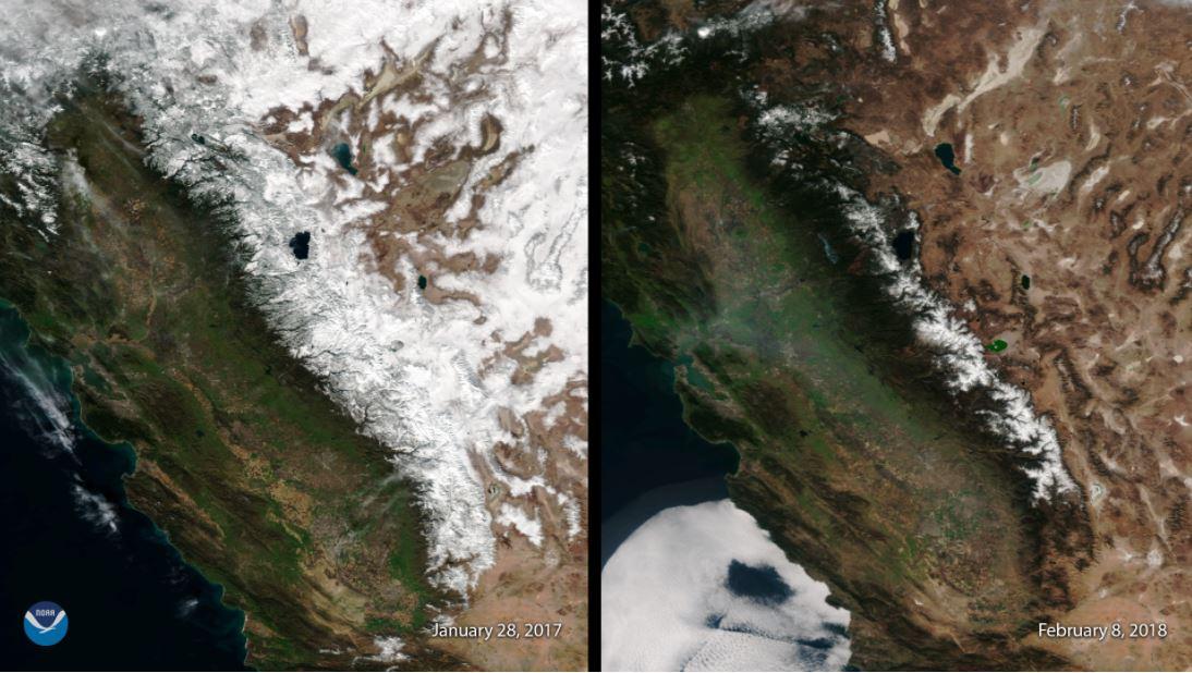
 But a picture of the snowpack last year, versus this year, really tells the story. The image on the left shows heavy snowpack on the Sierra Nevada on January 28th, 2017. The image on the right shows the lack of snowpack on the same area as of February 8th, 2018. The average snow depth across the Sierra Nevada is currently just 3.4 inches. Last year, at the same time, the average snow depth was 46.0 inches.
 So far this winter, most of the storm tracks have been starting in the northwest, and tracking to the southeast. These tracks have kept the eastern U.S. colder and wetter than average. However, much of the southwest has missed out on moisture from these storms, staying warmer and drier than usual. A persistent ridge of high pressure off the California coast, has been blocking the storms from the Pacific.
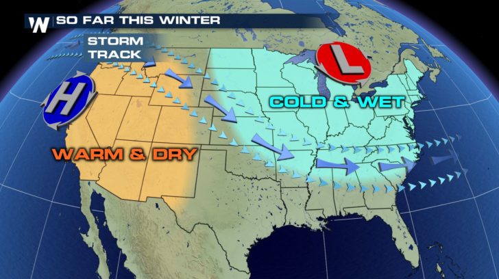 However, it looks like early next week, high pressure will be replaced by low pressure. This will funnel in Pacific moisture, and bring some rain and snow chances for the southwest.
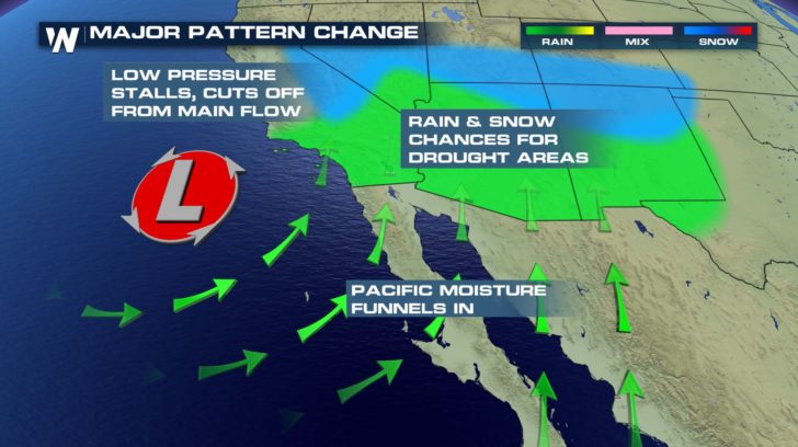 Water levels in California's reservoirs are still fairly high, so there are no immediate concerns. However, a dry winter means less spring and summer snow-melt, which helps keep reservoir levels high during the dry summer months. Hopefully low pressure systems will become more common for the remainder of winter, and the overall pattern will change from dry to wet. California and much of the southwest would benefit greatly from more rain and more mountain snow.
For WeatherNation: Meteorologist Matt Monroe
Water levels in California's reservoirs are still fairly high, so there are no immediate concerns. However, a dry winter means less spring and summer snow-melt, which helps keep reservoir levels high during the dry summer months. Hopefully low pressure systems will become more common for the remainder of winter, and the overall pattern will change from dry to wet. California and much of the southwest would benefit greatly from more rain and more mountain snow.
For WeatherNation: Meteorologist Matt MonroeAll Weather News
More
After Reaching Category 5, Genevieve Weakens in the Pacific
PacificGenevieve formed on last Friday south
2 Aug 2026 1:25 PM

More Storms for the East Sunday and Monday
A low-pressure system crashing through the Mi
2 Aug 2026 1:25 PM


Wildfire Outbreak in the Pacific Northwest
Conditions have been incredibly dry out west.
2 Aug 2026 12:20 PM

Flooding, Severe Storms Target the Midwest Again
After an active week of storms across the nor
1 Aug 2026 1:40 AM

Flooding Risk Increases as Heavy Rain Targets the Tri-State Area
Tuesday, heavy rainfall moved across the Nort
30 Jul 2026 12:25 AM

Severe Weather: Energy From the Midwest Now in the Southeast
UPPER MIDWEST - Through Monday, dangerous tor
29 Jul 2026 10:30 PM