Clipper System Brings More Snow To Northeast U.S.
Special Stories
17 Nov 2018 8:33 PM
Another round of snow is already underway across the central U.S. It's a textbook Alberta Clipper, essentially a cold front coming down from Canada. Snow and colder temperatures will accompany the front. Winter Weather Advisories are in effect for Sunday morning. If you look at the winter weather alerts below, you can easily see the trouble spots will be.
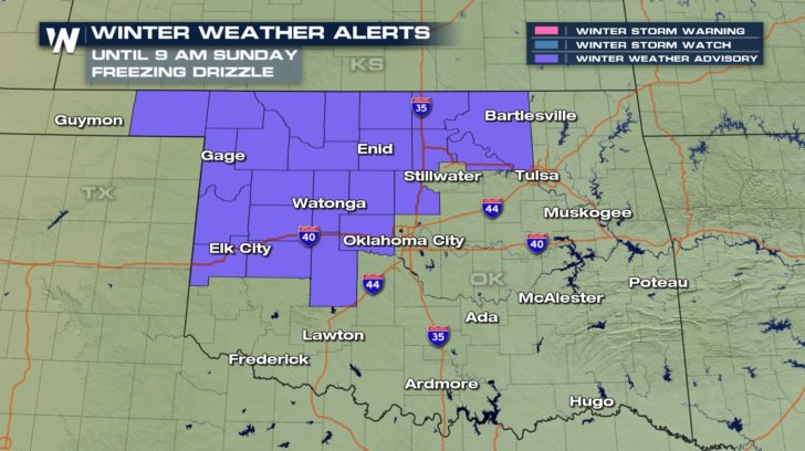 Light freezing fog and freezing drizzle will make things very slick on northwest Oklahoma roadways. Drive safely!
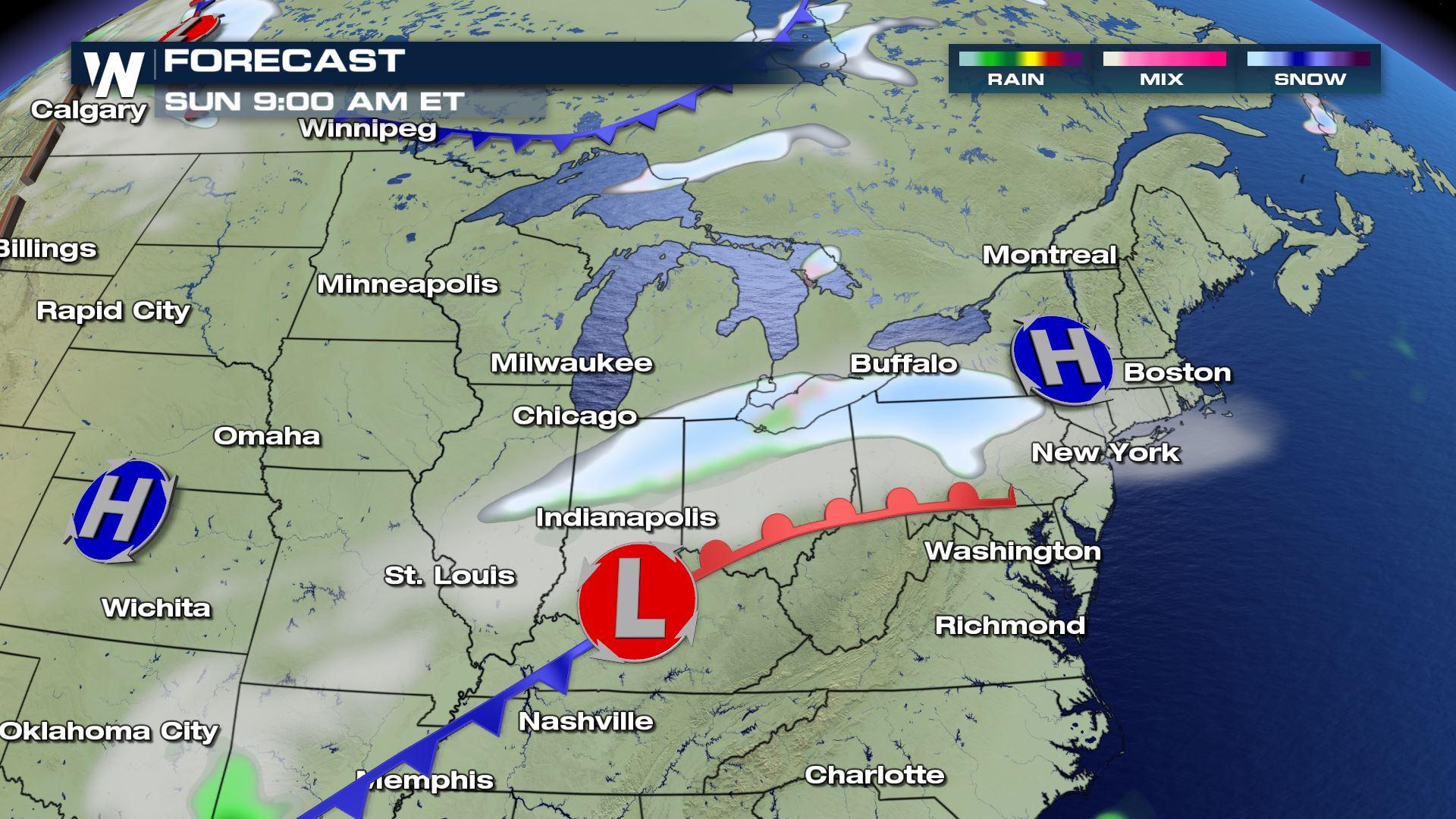
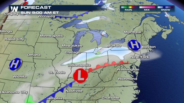
By Sunday morning a separate area of snowfall will be moving across the southern Great Lakes and parts of the Northeast.
Light freezing fog and freezing drizzle will make things very slick on northwest Oklahoma roadways. Drive safely!
By Sunday morning a separate area of snowfall will be moving across the southern Great Lakes and parts of the Northeast.
 This will be light to moderate snow as it moves northeast, just enough to coat the bridges, overpasses, and grassy surfaces.
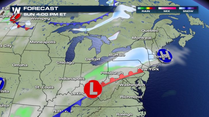 By late Sunday the low pressure system will bring the snow into New England with light, but icy accumulations.
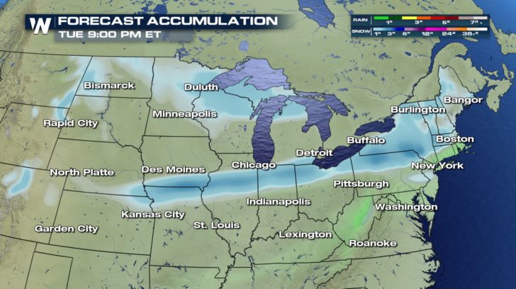 Here are the snowfall projections. The Sunday snow will bring 1-3" in the light blue/teal colors through the Northeast. But wait, there's more! Another low pressure system will scoot through the Great Lakes and Northeast on Tuesday morning bringing another accumulation.
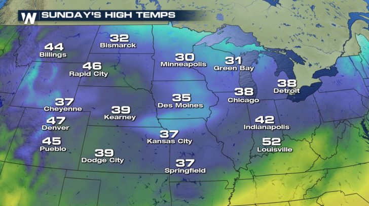
High temperatures will plummet behind the cold front. Look at cities like Bismarck and Minneapolis.
Here are the snowfall projections. The Sunday snow will bring 1-3" in the light blue/teal colors through the Northeast. But wait, there's more! Another low pressure system will scoot through the Great Lakes and Northeast on Tuesday morning bringing another accumulation.
High temperatures will plummet behind the cold front. Look at cities like Bismarck and Minneapolis.
 So get ready for another blast of winter weather in the middle of November. And remember, winter is still officially over a month away!
For WeatherNation: Meteorologist Matt Monroe
So get ready for another blast of winter weather in the middle of November. And remember, winter is still officially over a month away!
For WeatherNation: Meteorologist Matt Monroe
Light freezing fog and freezing drizzle will make things very slick on northwest Oklahoma roadways. Drive safely!
By Sunday morning a separate area of snowfall will be moving across the southern Great Lakes and parts of the Northeast.
This will be light to moderate snow as it moves northeast, just enough to coat the bridges, overpasses, and grassy surfaces.
By late Sunday the low pressure system will bring the snow into New England with light, but icy accumulations.
Here are the snowfall projections. The Sunday snow will bring 1-3" in the light blue/teal colors through the Northeast. But wait, there's more! Another low pressure system will scoot through the Great Lakes and Northeast on Tuesday morning bringing another accumulation.
High temperatures will plummet behind the cold front. Look at cities like Bismarck and Minneapolis.
So get ready for another blast of winter weather in the middle of November. And remember, winter is still officially over a month away!
For WeatherNation: Meteorologist Matt MonroeAll Weather News
More

More Storms for the East Through Monday
A low-pressure system that moved through the
3 Aug 2026 12:20 PM


After Reaching Category 5, Genevieve Weakens in the Pacific
PacificGenevieve formed last Friday south of
3 Aug 2026 12:30 AM

Flooding, Severe Storms Target the Midwest Again
After an active week of storms across the nor
1 Aug 2026 1:40 AM

Flooding Risk Increases as Heavy Rain Targets the Tri-State Area
Tuesday, heavy rainfall moved across the Nort
30 Jul 2026 12:25 AM