Clouds or Snow on Satellite? Here Are a Few Ways to Tell the Difference
Special Stories
11 Dec 2018 12:51 PM
[NOAA] At first glance, satellite imagery of the Earth can make it look like a giant blue and green marble with swirls of white. For many of us, that makes it hard to imagine how researchers and forecasters are able to determine whether those swirls of white are clouds or snow. However, being able to pinpoint snow cover is important because it can be used for search and rescue missions, water supply resource monitoring and management, as well as short-term forecasting.
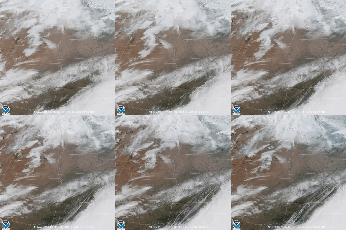 The above GOES East imagery from Nov. 13, 2018, is an example of clouds moving very quickly, but snow changing ever so slightly as it melts in Kansas, Oklahoma, Missouri, Illinois and a few other surrounding states.
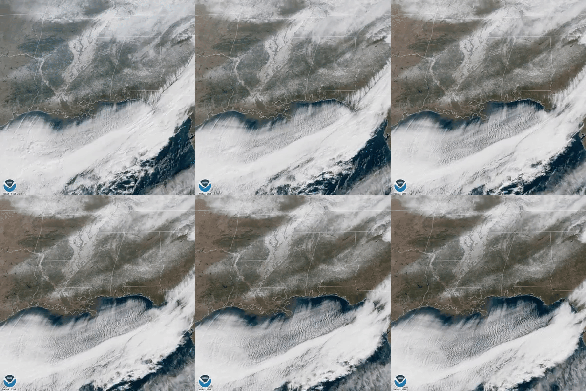 A swath of snow stretches across Louisiana, Mississippi, Alabama and Georgia in this GOES East imagery from Jan. 17, 2018. The snow coverage doesn’t change until the end of the loop, and even then, the melt happens very slowly.
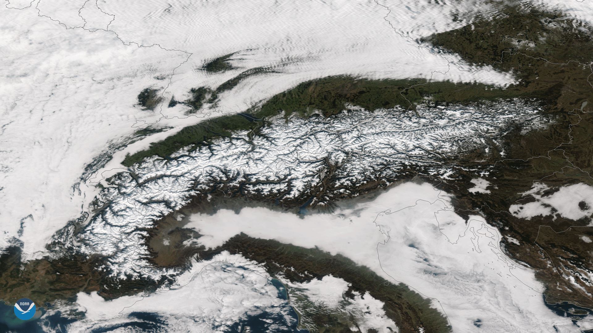 [This image captured by the Suomi NPP satellite on Jan. 29, 2018 shows snow cover over the European Alps. The Alps themselves are cloud-free, but surrounded by clouds on the top and the bottom of the image.]
Snow cover is easily detected in still images like this because clouds have a very different texture.
“Clouds are kind of puffy and they look kind of puffy in the imagery,” Meier said. “You see kind of a texture to it that you don’t see in the snow cover.”
[This image captured by the Suomi NPP satellite on Jan. 29, 2018 shows snow cover over the European Alps. The Alps themselves are cloud-free, but surrounded by clouds on the top and the bottom of the image.]
Snow cover is easily detected in still images like this because clouds have a very different texture.
“Clouds are kind of puffy and they look kind of puffy in the imagery,” Meier said. “You see kind of a texture to it that you don’t see in the snow cover.”
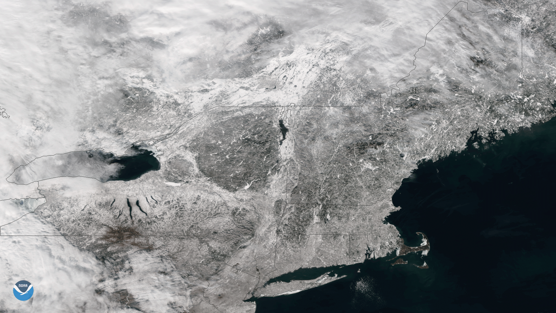 [In this Suomi NPP imagery from January 10, 2018 the clouds are wispy over Lake Ontario and the snow on the ground in New England appears more flat.]
Meier added that rivers, if they’re not frozen, will be warm relative to the land or the clouds so they’ll show up more easily. Even bodies of water that are frozen or snow covered can still be helpful because oftentimes there’s still a gradation in the snow.
“You’ll still pick out the edge of the river because typically there’s some topography as you slope down to the river bank,” Meier said. “Then the river winds so you’ll be able to see that and that can help discriminate whether that’s clear or cloudy.”
[In this Suomi NPP imagery from January 10, 2018 the clouds are wispy over Lake Ontario and the snow on the ground in New England appears more flat.]
Meier added that rivers, if they’re not frozen, will be warm relative to the land or the clouds so they’ll show up more easily. Even bodies of water that are frozen or snow covered can still be helpful because oftentimes there’s still a gradation in the snow.
“You’ll still pick out the edge of the river because typically there’s some topography as you slope down to the river bank,” Meier said. “Then the river winds so you’ll be able to see that and that can help discriminate whether that’s clear or cloudy.”
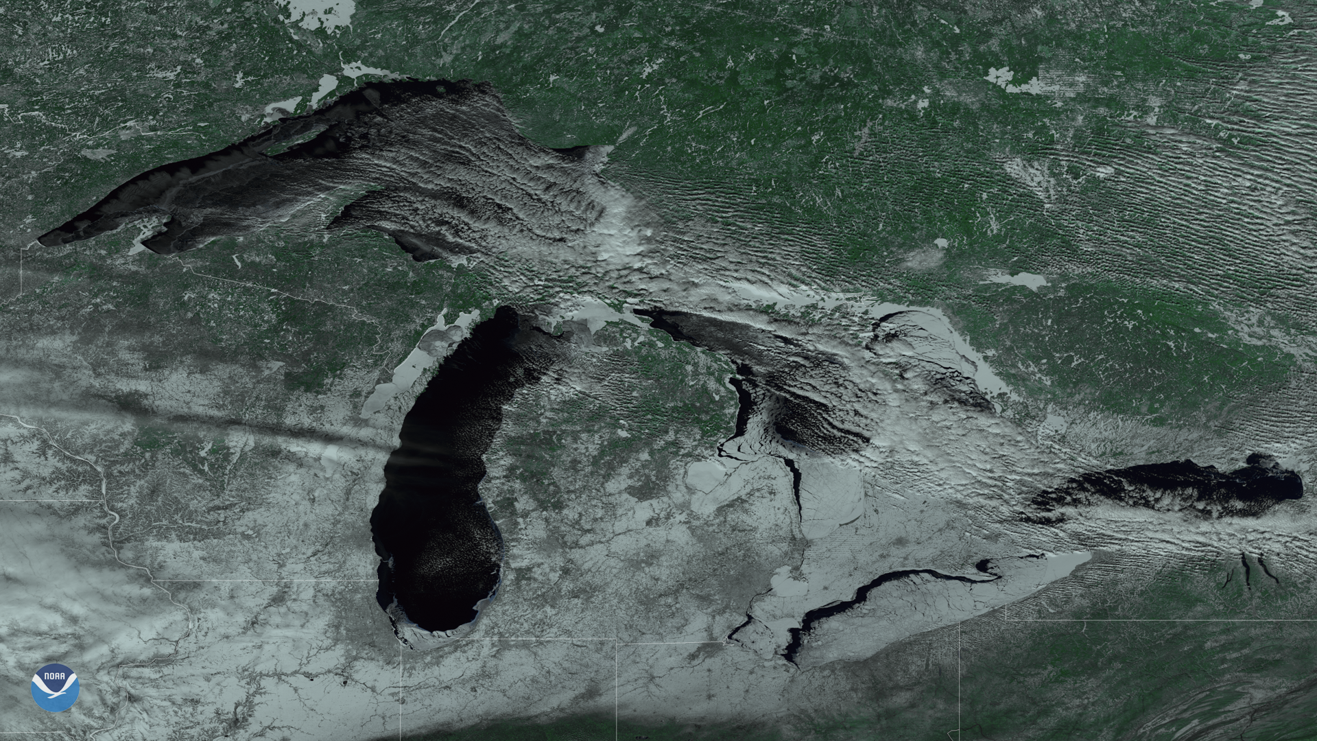 [This Feb. 12, 2018 color-enhanced imagery from the Suomi NPP satellite’s VIIRS instrument is another example of how dark bodies of water, like the Great Lakes, can help make the presence of snow and ice more recognizable in satellite imagery.]
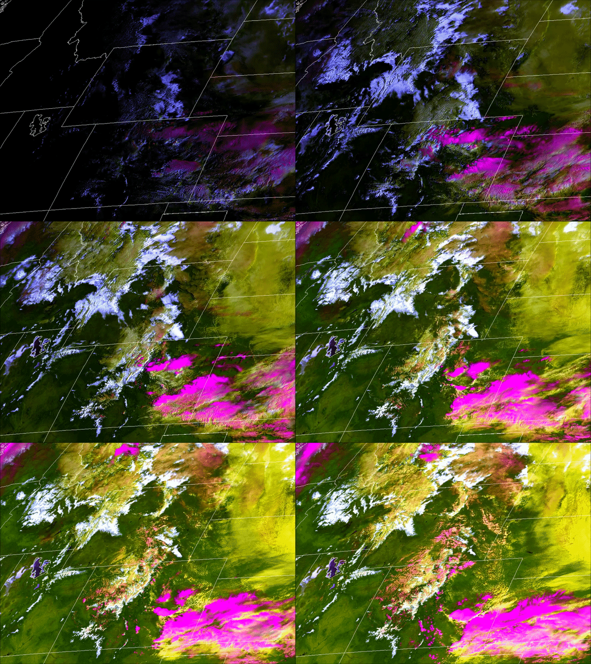 Another tool that is commonly used to differentiate between clouds and snow is the Cloud Layers & Snow Cover Discriminator. This tool was developed by the Cooperative Institute for Research in the Atmosphere (CIRA) and uses both visible and shortwave infrared bands on the MODerate-resolution Imaging Spectroradiometer (MODIS) sensor.
The Cloud Layers & Snow Cover Discriminator takes into account many of the same things the NDSI tool does, but it uses additional channels from the MODIS to help address the cloud/snow ambiguity problem caused by certain types of cirrus clouds. This tool utilizes Bands 5, 4, 2 and 14 to visually depict land, snow and clouds using certain colors.
Another tool that is commonly used to differentiate between clouds and snow is the Cloud Layers & Snow Cover Discriminator. This tool was developed by the Cooperative Institute for Research in the Atmosphere (CIRA) and uses both visible and shortwave infrared bands on the MODerate-resolution Imaging Spectroradiometer (MODIS) sensor.
The Cloud Layers & Snow Cover Discriminator takes into account many of the same things the NDSI tool does, but it uses additional channels from the MODIS to help address the cloud/snow ambiguity problem caused by certain types of cirrus clouds. This tool utilizes Bands 5, 4, 2 and 14 to visually depict land, snow and clouds using certain colors.
Looped Imagery
One of the easiest ways to differentiate between snow and clouds is by looking at a series of images or looped imagery. “As the clouds move, the snow may change, but it changes much more slowly generally,” explained Walt Meier, a senior research scientist at the National Snow & Ice Data Center.
The above GOES East imagery from Nov. 13, 2018, is an example of clouds moving very quickly, but snow changing ever so slightly as it melts in Kansas, Oklahoma, Missouri, Illinois and a few other surrounding states.
A swath of snow stretches across Louisiana, Mississippi, Alabama and Georgia in this GOES East imagery from Jan. 17, 2018. The snow coverage doesn’t change until the end of the loop, and even then, the melt happens very slowly.
Different Textures
The texture differences between clouds and snow are also a good indicator, according to Meier.
[This image captured by the Suomi NPP satellite on Jan. 29, 2018 shows snow cover over the European Alps. The Alps themselves are cloud-free, but surrounded by clouds on the top and the bottom of the image.]
Snow cover is easily detected in still images like this because clouds have a very different texture.
“Clouds are kind of puffy and they look kind of puffy in the imagery,” Meier said. “You see kind of a texture to it that you don’t see in the snow cover.”
Terrain Features
Topography is another way forecasters can differentiate between snow and clouds. Bodies of water show up very dark, or even black so the edges are typically visible from satellite imagery even if snow surrounds it.
[In this Suomi NPP imagery from January 10, 2018 the clouds are wispy over Lake Ontario and the snow on the ground in New England appears more flat.]
Meier added that rivers, if they’re not frozen, will be warm relative to the land or the clouds so they’ll show up more easily. Even bodies of water that are frozen or snow covered can still be helpful because oftentimes there’s still a gradation in the snow.
“You’ll still pick out the edge of the river because typically there’s some topography as you slope down to the river bank,” Meier said. “Then the river winds so you’ll be able to see that and that can help discriminate whether that’s clear or cloudy.”
[This Feb. 12, 2018 color-enhanced imagery from the Suomi NPP satellite’s VIIRS instrument is another example of how dark bodies of water, like the Great Lakes, can help make the presence of snow and ice more recognizable in satellite imagery.]
Different Snow Products
So what do forecasters do when a visible inspection just isn’t enough? Well, there are several tools that can help. William Straka, a researcher for the Cooperative Institute for Meteorological Satellite Studies at the University of Wisconsin-Madison, explained that scientists often use the Normalized Difference Snow Index (NDSI) to quickly detect and monitor likely snow cover. Using just the visible band (Band 2) on the the GOES East (and West) Advanced Baseline Imager (ABI) to detect to the presence of snow during the day is extremely difficult. This is because snow and clouds are both very reflective (i.e. bright) at this wavelength. However, the near infrared channel, Band 5, snow absorbs sunlight, which means it appears much darker than most of the clouds. NDSI combines the two channels, making it easier to differentiate between snow cover and clouds fairly quickly. Meier added that this isn’t a foolproof tool because even using these two bands, a cloud could be the same temperature as the snow. In other words, it doesn’t completely rid researchers and forecasters of cloud/snow ambiguity.
Another tool that is commonly used to differentiate between clouds and snow is the Cloud Layers & Snow Cover Discriminator. This tool was developed by the Cooperative Institute for Research in the Atmosphere (CIRA) and uses both visible and shortwave infrared bands on the MODerate-resolution Imaging Spectroradiometer (MODIS) sensor.
The Cloud Layers & Snow Cover Discriminator takes into account many of the same things the NDSI tool does, but it uses additional channels from the MODIS to help address the cloud/snow ambiguity problem caused by certain types of cirrus clouds. This tool utilizes Bands 5, 4, 2 and 14 to visually depict land, snow and clouds using certain colors.
Test Yourself!
Want to test your new knowledge? Take a look at some of our other imagery that wasn’t in this article. See if you can tell which technique was used just by looking at the imagery. If you can’t figure it out, all the answers will be below the imagery. Good luck! Edited for WeatherNation by Meteorologist Mace MichaelsAll Weather News
More
SW Low Moves East, Brings Flood Threat to the Plains
A powerful low pressure system has been movin
23 Oct 2026 2:00 PM

Hurricane Vance Strengthens In The Pacific
Hurricane Vance continues to strengthen in th
23 Oct 2026 1:00 PM

Warmer Than Average: Above-Normal Temperatures Across the Central U.S. This Week
WHAT TO EXPECTA ridge of high pressure linger
23 Oct 2026 1:00 PM


Several Fires Break Out in SoCal Last Week Amid Santa Ana Wind Event
Santa Ana winds helped several fires grow qui
19 Oct 2026 1:25 PM

Another Cold Morning Before Things Warm Back Up
Across portions of the Ohio Valley through th
19 Oct 2026 10:15 AM

Severe Risk Diminishing Saturday Morning for the Northeast
Severe Storm PotentialSevere risk is decreasi
16 Oct 2026 10:20 AM