Cold Front Brings Severe Weather to the Southeast
Special Stories
22 Jul 2018 10:37 AM
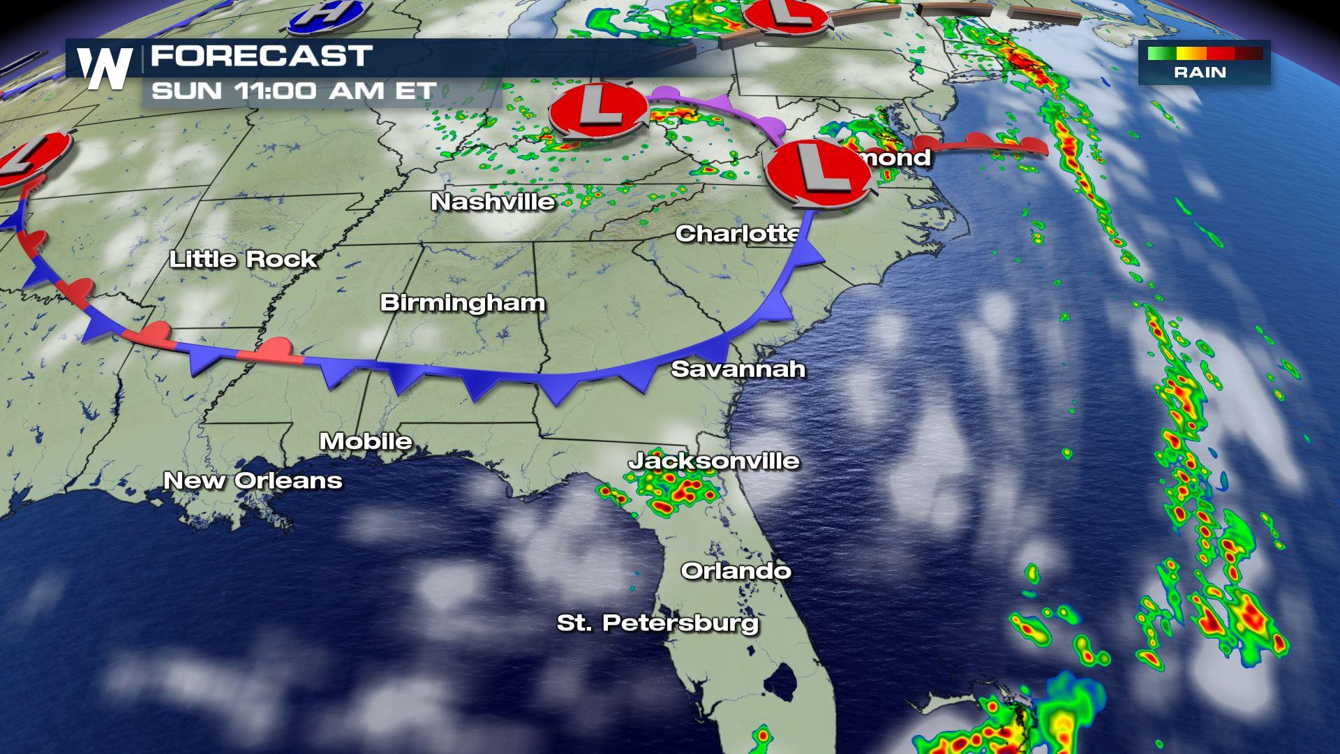
A cold front moving through the southeast will bring severe weather for today and tomorrow.
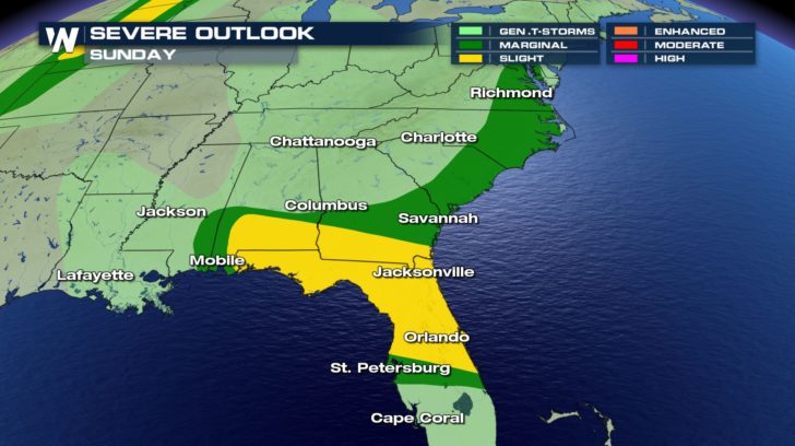 There is a slight risk of severe weather for parts of Florida, southern Georgia, and southern Alabama. A marginal risk of severe weather extends all the way up to Washington D.C.
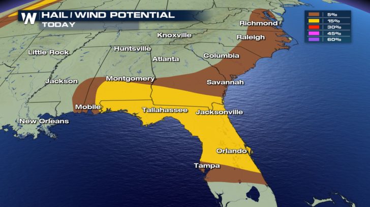 Winds around 60 mph or greater could occur within some of these storms. We could even see hail that is 1-2 inches in diameter.
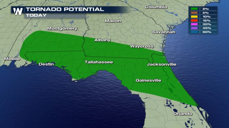 A possible tornado could be spotted throughout Florida, Georgia, and Alabama.
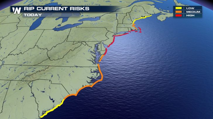 With the possible severe thunderstorms and strong winds we could see today, we have the potential for rip currents, as well. There have already been 3 reported deaths off the coast of North Carolina. Remember to ALWAYS observe the flags on the beach. Stay safe today, everyone.
For WeatherNation -Meteorologist Shelly Lindblade
With the possible severe thunderstorms and strong winds we could see today, we have the potential for rip currents, as well. There have already been 3 reported deaths off the coast of North Carolina. Remember to ALWAYS observe the flags on the beach. Stay safe today, everyone.
For WeatherNation -Meteorologist Shelly Lindblade
There is a slight risk of severe weather for parts of Florida, southern Georgia, and southern Alabama. A marginal risk of severe weather extends all the way up to Washington D.C.
Winds around 60 mph or greater could occur within some of these storms. We could even see hail that is 1-2 inches in diameter.
A possible tornado could be spotted throughout Florida, Georgia, and Alabama.
With the possible severe thunderstorms and strong winds we could see today, we have the potential for rip currents, as well. There have already been 3 reported deaths off the coast of North Carolina. Remember to ALWAYS observe the flags on the beach. Stay safe today, everyone.
For WeatherNation -Meteorologist Shelly LindbladeAll Weather News
More


More Storms for the East Sunday and Monday
A low-pressure system crashing through the Mi
2 Aug 2026 2:20 AM

After Reaching Category 5, Genevieve Weakens in the Pacific
PacificGenevieve formed on last Friday south
2 Aug 2026 1:30 AM

Flooding, Severe Storms Target the Midwest Again
After an active week of storms across the nor
1 Aug 2026 1:40 AM

Flooding Risk Increases as Heavy Rain Targets the Tri-State Area
Tuesday, heavy rainfall moved across the Nort
30 Jul 2026 12:25 AM

Severe Weather: Energy From the Midwest Now in the Southeast
UPPER MIDWEST - Through Monday, dangerous tor
29 Jul 2026 10:30 PM