Communicating Tropical Storm Risks Through A Sense Of Place
Special Stories
15 Aug 2019 1:50 AM
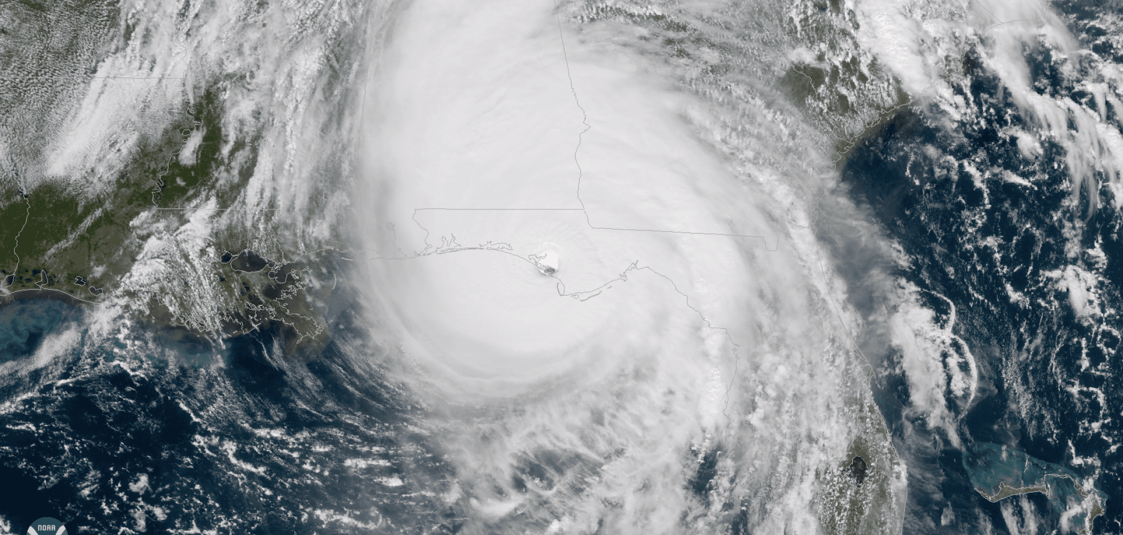
[Hurricane Michael making landfall at Mexico Beach, FL on October 10th, 2018]
[NCAR] As hurricane forecasts become more accurate, scientists are increasingly turning their attention to communicating those forecasts to vulnerable communities in a meaningful way. The goal is to enable residents and local officials to see how the incoming storm could affect specific areas so they can make critical decisions about protecting their lives, homes, and businesses.
The National Center for Atmospheric Research (NCAR) is leading a new, two-year project to study the use of maps and other visualizations to characterize and communicate risks related to coastal surge and flooding. The project, funded by the National Science Foundation (NSF), brings together scientists at NCAR and leading universities across a range of disciplines to better understand how certain types of geovisualizations will resonate with particular populations.
The researchers will focus on a concept known as "sense of place" — essentially how residents identify with the area where they live, including the emotional connection they form with their local community and environment. For inhabitants of a barrier island, that might be an environmental feature such as a river or inlet. For those living in urban areas or smaller towns, it might be schools, parks, or historic landmarks.
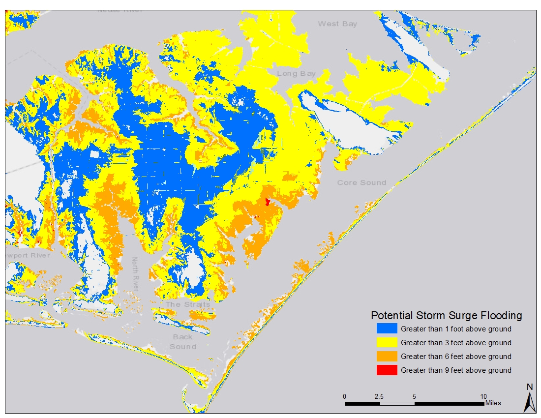 [Coastal North Carolina storm surge map]
"By focusing on local features that coastal communities identify with, visualizations can help the residents locate themselves in relation to the potential threats from storm surge," said Olga Wilhelmi, an NCAR geographer who is leading the project. "This communicates the risks in a way that's most meaningful to residents so they can make informed decisions, such as whether to evacuate or shelter in place."
Focus groups and surveys
The research team will conduct focus groups to better understand localized sense of place. They will then create specialized maps, 3-D animations, and other visualizations that incorporate sense of place representations to assess how they differently convey information to people about risk of storm surge.
For example, a map could highlight local schools and highways that would be flooded from an incoming hurricane. An animation could show rising waters approaching the types of houses that local residents live in. The scientists will then survey coastal residents to test the effectiveness of the various visual approaches.
[Coastal North Carolina storm surge map]
"By focusing on local features that coastal communities identify with, visualizations can help the residents locate themselves in relation to the potential threats from storm surge," said Olga Wilhelmi, an NCAR geographer who is leading the project. "This communicates the risks in a way that's most meaningful to residents so they can make informed decisions, such as whether to evacuate or shelter in place."
Focus groups and surveys
The research team will conduct focus groups to better understand localized sense of place. They will then create specialized maps, 3-D animations, and other visualizations that incorporate sense of place representations to assess how they differently convey information to people about risk of storm surge.
For example, a map could highlight local schools and highways that would be flooded from an incoming hurricane. An animation could show rising waters approaching the types of houses that local residents live in. The scientists will then survey coastal residents to test the effectiveness of the various visual approaches.
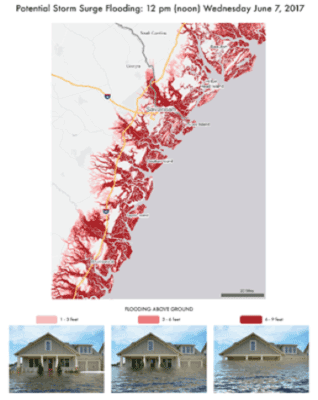 [An example of a visualization of a hypothetical storm surge forecast. Image: NCAR geographer Olga Wilhelmi and collaborators.]
The research will concentrate on coastal Georgia and South Carolina, which have been repeatedly affected by hurricanes and associated storm surge in recent years. But the results will be broadly applicable to other populated areas that are at risk from storm surge or other disasters.
The project brings together scientists from a range of disciplines, including experts in Geographic Information Systems (GIS), cartography, storm surge, social vulnerability, and risk communication. It builds on prior work at NCAR that has analyzed how visualizations can communicate risks to vulnerable residents, although without an emphasis on a sense of place. That work was also funded by NSF, which is NCAR's sponsor.
"We want to bridge the gap between the ways that geophysical scientists convey information about storm surge and how the public interprets and uses the information," Wilhelmi said. "The end goal is to reduce the devastating effects that storm surges can have on the safety and well-being of vulnerable communities."
Edited for WeatherNation by Meteorologist Mace Michaels
[An example of a visualization of a hypothetical storm surge forecast. Image: NCAR geographer Olga Wilhelmi and collaborators.]
The research will concentrate on coastal Georgia and South Carolina, which have been repeatedly affected by hurricanes and associated storm surge in recent years. But the results will be broadly applicable to other populated areas that are at risk from storm surge or other disasters.
The project brings together scientists from a range of disciplines, including experts in Geographic Information Systems (GIS), cartography, storm surge, social vulnerability, and risk communication. It builds on prior work at NCAR that has analyzed how visualizations can communicate risks to vulnerable residents, although without an emphasis on a sense of place. That work was also funded by NSF, which is NCAR's sponsor.
"We want to bridge the gap between the ways that geophysical scientists convey information about storm surge and how the public interprets and uses the information," Wilhelmi said. "The end goal is to reduce the devastating effects that storm surges can have on the safety and well-being of vulnerable communities."
Edited for WeatherNation by Meteorologist Mace Michaels
[Coastal North Carolina storm surge map]
"By focusing on local features that coastal communities identify with, visualizations can help the residents locate themselves in relation to the potential threats from storm surge," said Olga Wilhelmi, an NCAR geographer who is leading the project. "This communicates the risks in a way that's most meaningful to residents so they can make informed decisions, such as whether to evacuate or shelter in place."
Focus groups and surveys
The research team will conduct focus groups to better understand localized sense of place. They will then create specialized maps, 3-D animations, and other visualizations that incorporate sense of place representations to assess how they differently convey information to people about risk of storm surge.
For example, a map could highlight local schools and highways that would be flooded from an incoming hurricane. An animation could show rising waters approaching the types of houses that local residents live in. The scientists will then survey coastal residents to test the effectiveness of the various visual approaches.
[An example of a visualization of a hypothetical storm surge forecast. Image: NCAR geographer Olga Wilhelmi and collaborators.]
The research will concentrate on coastal Georgia and South Carolina, which have been repeatedly affected by hurricanes and associated storm surge in recent years. But the results will be broadly applicable to other populated areas that are at risk from storm surge or other disasters.
The project brings together scientists from a range of disciplines, including experts in Geographic Information Systems (GIS), cartography, storm surge, social vulnerability, and risk communication. It builds on prior work at NCAR that has analyzed how visualizations can communicate risks to vulnerable residents, although without an emphasis on a sense of place. That work was also funded by NSF, which is NCAR's sponsor.
"We want to bridge the gap between the ways that geophysical scientists convey information about storm surge and how the public interprets and uses the information," Wilhelmi said. "The end goal is to reduce the devastating effects that storm surges can have on the safety and well-being of vulnerable communities."
Edited for WeatherNation by Meteorologist Mace MichaelsAll Weather News
More
Flooding, Severe Storms Target the Midwest Again
After an active week of storms across the nor
31 Jul 2026 8:05 PM


After Reaching Category 5, Genevieve Weakens in the Pacific
PacificFausto is now a post-tropical cyclone.
31 Jul 2026 1:30 AM

Flooding Risk Increases as Heavy Rain Targets the Tri-State Area
Tuesday, heavy rainfall moved across the Nort
30 Jul 2026 12:25 AM

Severe Weather: Energy From the Midwest Now in the Southeast
UPPER MIDWEST - Through Monday, dangerous tor
29 Jul 2026 10:30 PM